02 C14-2025-0110 - 12224 ½ N IH-35; District 7 - Staff Report — original pdf
Backup
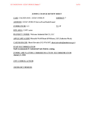
ZONING CHANGE REVIEW SHEET CASE: C14-2025-0110 - 12224 ½ N IH-35 DISTRICT: 7 ADDRESS: 12224 ½ N IH-35 Service Road South Bound ZONING FROM: LO TO: IP SITE AREA: 3.5471 acres PROPERTY OWNER: Welcome Industrial Sub 21, LLC APPLICANT/AGENT: Metcalfe Wolff Stuart &Williams, LLP, Katherine Nicely CASE MANAGER: Sherri Sirwaitis (512-974-3057, sherri.sirwaitis@austintexas.gov) STAFF RECOMMEDATION: Staff recommends IP, Industrial Park District, zoning. ZONING AND PLATTING COMMISSION ACTION / RECOMMENDATION: January 6, 2026 CITY COUNCIL ACTION: ORDINANCE NUMBER: 02 C14-2025-0110 - 12224 ½ N IH-35; District 71 of 11 ISSUES: N/A CASE MANAGER COMMENTS: The property in question is 3.5471 acre portion of a larger tract of land that fronts onto the North Interstate-Highway-35 South Bound Service Road. The site is developed with a two- story office/warehouse structure that contains limited warehouse and distribution uses, with surface parking (Advanced Manufacturing R&D). There is a warehouse structure (Culligan) to the north along W. Yager Lane that is zoned LI. The lots to the south are developed with 3-story office buildings (TCEQ) that are zoned GO and IP fronting Park Thirty Five Circle and a construction sales and services use (Hercules Wire Rope & Sling Co.) zoned GR that fronts the IH-35 Service Road. To the west, there is floodplain zoned RR, a warehouse structure with outdoor storage zoned LO and a detention pond zoned IP. In this case, the applicant is requesting IP zoning so that it will be consistent with the existing zoning on the larger portion of this lot to the west (please see Applicant's Request Letter - Exhibit C). The staff recommends IP, Industrial Park District, zoning. The property meets the intent of the IP district as it is located on a major corridor near office, commercial and industrial uses and zoning. It is part of an industrial area and it is located within 0.30 miles from Lamar Boulevard Activity Corridor, as designated by the Imagine Austin Comprehensive Plan. The applicant agrees with the staff’s recommendation. BASIS OF RECOMMENDATION: 1. The proposed zoning should be consistent with the purpose statement of the district sought. Industrial Park district is intended as an area for limited commercial services, research and development, administrative facilities, and manufacturing uses that can meet high development and performance standards, and typically are located on large sites or in planned industrial centers. 2. The proposed zoning should promote consistency and orderly planning. The site under consideration is located adjacent to IP, LI, GR, GO and LO zoning in an area with office, commercial and industrial uses. This property is within 0.30 miles from a designated activity corridor. The proposed zoning will permit consistent zoning over the entire lot that is currently being used for a limited warehousing and distribution use. EXISTING ZONING AND LAND USES: ZONING LAND USES Site LO North LI Limited Warehousing and Distribution, with surface parking (Advanced Manufacturing R&D) Construction Sales and Services (Culligan) 02 C14-2025-0110 - 12224 ½ N IH-35; District 72 of 11 South GO, IP, GR East West ROW IP, RR, LO Office (TCEQ), Construction Sales and Services (Hercules Wire Rope & Sling Co.) Interstate Highway-35 Limited Warehousing and Distribution (Advanced Manufacturing R&D), Floodplain, Warehouse with Outdoor Storage NEIGHBORHOOD PLANNING AREA: N/A WATERSHED: Walnut Creek CAPITOL VIEW CORRIDOR: N/A SCENIC ROADWAY: N/A NEIGHBORHOOD ORGANIZATIONS: Austin Neighborhoods Council, Friends of Austin Neighborhoods, Homeless Neighborhood Association, Pflugerville Independent School District, Walnut Creek Neighborhood Assn., Inc., Yager Community SCHOOLS: Pflugerville I.S.D. River Oaks Elementary School Westview Middle School Connally High School AREA CASE HISTORIES: NUMBER C14-2018-0063 - 12427 Tech Ridge Boulevard COMMISSION 07/17/2018: To grant with additional prohibited uses: Adult oriented businesses, Construction sales & services CITY COUNCIL 08/23/2018: To grant CS-CO as rec. by ZAP; Ord. No. 20180823-065 REQUEST GR to CS-CO, prohibiting Agricultural sales & services, Campground, Electronic prototype assembly, Equipment repair services, Food preparation, Laundry services, Plant nursery, Veterinary services, Indoor crop production, Building maintenance services, Commercial blood plasma center, Electronic Testing, Equipment sales, Kennels, Monument retail sales, Vehicle storage, Limited warehousing & distribution, Maintenance & service facilities, Transitional housing, Transportation terminal 02 C14-2025-0110 - 12224 ½ N IH-35; District 73 of 11 12/05/2017: To grant Staff rec. with CO: max 2,000 vpd 05/03/2016: Forward without recommendation 06/2014: To grant MF-2 08/09/2018: To grant MF-2-CO as rec. by ZAP; Ord. No. 20180809-076 WITHDRAWN 06/26/14: Approved 1st reading only 04/16/2015: To grant MF-2 on 2nd/3rd readings; Ord. 20150416-010 C14-2017-0096 - Walnut Park II LO to MF-2 C14-2016-0014 - 211 Canyon Ridge Drive Hotel C14-2014-0053 - Walnut Park Crossing LI to LI-PDA with 80’ height LO to MF-2 RELATED CASES: C14-85-149 – North Lamar Area Study OTHER STAFF COMMENTS: Comprehensive Planning Project Name and Proposed Use: 12234 N IH 35 SERVICE ROAD SB. C14-2025-0110. Project: 12224 1/2 N IH-35. 3.5471 acres from LO to IP. Existing: limited warehouse and distribution. Proposed: limited warehouse and distribution. Yes Y Imagine Austin Decision Guidelines Complete Community Measures * Imagine Austin Growth Concept Map: Located within or adjacent to an Imagine Austin Activity Center, Imagine Austin Activity Corridor, or Imagine Austin Job Center as identified the Growth Concept Map. Names of Activity Centers/Activity Corridors/Job Centers *: • 0.30 miles from Lamar Boulevard Activity Corridor Mobility and Public Transit *: Located within 0.25 miles of public transit stop and/or light rail station. Y Mobility and Bike/Ped Access *: Adjoins a public sidewalk, shared path, and/or bike lane. • Sidewalk present along I-35 Frontage RD Y Connectivity, Good and Services, Employment *: Provides or is located within 0.50 miles to goods and services, and/or employment center. • Within 0.5 miles of higher job levels as per Census OnTheMap Connectivity and Food Access *: Provides or is located within 0.50 miles of a grocery store/farmers market. Connectivity and Education *: Located within 0.50 miles from a public school or university. Connectivity and Healthy Living *: Provides or is located within 0.50 miles from a recreation area, park or walking trail. 02 C14-2025-0110 - 12224 ½ N IH-35; District 74 of 11 Connectivity and Health *: Provides or is located within 0.50 miles of health facility (ex: hospital, urgent care, doctor’s office, drugstore clinic, and/or specialized outpatient care.) Housing Choice *: Expands the number of units and housing choice that suits a variety of household sizes, incomes, and lifestyle needs of a diverse population (ex: apartments, triplex, granny flat, live/work units, cottage homes, and townhomes) in support of Imagine Austin and the Strategic Housing Blueprint. Housing Affordability *: Provides a minimum of 10% of units for workforce housing (80% MFI or less) and/or fee in lieu for affordable housing. Mixed use *: Provides a mix of residential and non-industrial uses. Culture and Creative Economy *: Provides or is located within 0.50 miles of a cultural resource (ex: library, theater, museum, cultural center). Culture and Historic Preservation: Preserves or enhances a historically and/or culturally significant site. Creative Economy: Expands Austin’s creative economy (ex: live music venue, art studio, film, digital, theater.) Workforce Development, the Economy and Education: Expands the economic base by creating permanent jobs, especially in industries that are currently not represented in a particular area or that promotes a new technology, and/or promotes educational opportunities and workforce development training. Industrial Land: Preserves or enhances industrial land. Y Y Not located over Edwards Aquifer Contributing Zone or Edwards Aquifer Recharge Zone 5 Number of “Yes’s” Drainage The developer is required to submit a pre- and post-development drainage analysis at the subdivision and site plan stage of the development process. The City’s Land Development Code and Drainage Criteria Manual require that the Applicant demonstrate through engineering analysis that the proposed development will have no identifiable adverse impact on surrounding properties. Environmental The site is not located over the Edwards Aquifer Recharge Zone. The site is in the Walnut Creek Watershed of the Colorado River Basin, which is classified as a Suburban Watershed by Chapter 25-8 of the City's Land Development Code. The site is in the Desired Development Zone. Under current watershed regulations, development or redevelopment on this site will be subject to the following impervious cover limits: 02 C14-2025-0110 - 12224 ½ N IH-35; District 75 of 11 Development Classification % of Gross Site Area % of Gross Site Area Single-Family (minimum lot size 5750 sq. ft.) Other Single-Family or Duplex Multifamily Commercial 50% 55% 60% 80% with Transfers 60% 60% 70% 90% According to floodplain maps there is a floodplain within or adjacent to the project location. Based upon the location of the floodplain, offsite drainage should be calculated to determine whether a Critical Water Quality Zone exists within the project location.> Standard landscaping and tree protection will be required in accordance with LDC 25-2 and 25-8 for all development and/or redevelopment. At this time, site specific information is unavailable regarding vegetation, areas of steep slope, or other environmental features such as bluffs, springs, canyon rimrock, caves, sinkholes, and wetlands. Under current watershed regulations, development or redevelopment requires water quality control with increased capture volume and control of the 2 year storm on site. At this time, no information has been provided as to whether this property has any preexisting approvals that preempt current water quality or Code requirements. Fire No comments. Parks and Recreation Parkland dedication fees may apply to any future site or subdivision applications resulting from this rezoning. As of January 1, 2024, new commercial, non-residential uses are not subject to parkland dedication requirements at the time of site plan and subdivision. Site Plan Site plans will be required for any new development except for residential only project with up to 4 units. Any new development is subject to Subchapter E. Design Standards and Mixed Use. Additional comments will be made when the site plan is submitted. 02 C14-2025-0110 - 12224 ½ N IH-35; District 76 of 11 Transportation The adjacent street characteristics table is provided below: Name ASMP Classification ASMP Required ROW Existing ROW Existing Pavement Sidewalks Bicycle Route Capital Metro (within ¼ mile) N IH-35 Level 4 TXDOT Roadway TXDOT Roadway TXDOT Roadway Yes No No Water Utility No comments on zoning change. FYI: The landowner intends to serve the site with existing City of Austin water utilities. Based on current public infrastructure configurations, it appears that service extension requests (SER) will be required to provide service to this lot. For more information pertaining to the Service Extension Request process and submittal requirements contact the Austin Water SER team at ser@austintexas.gov. INDEX OF EXHIBITS TO FOLLOW A: Zoning Map B. Aerial Map C. Applicant’s Request Letter 02 C14-2025-0110 - 12224 ½ N IH-35; District 77 of 11 EXHIBIT A 02 C14-2025-0110 - 12224 ½ N IH-35; District 78 of 11 EXHIBIT B !!!!!!!!!!!!!!!!!!!!!!!!!!!!!!!!!!!!!!!!!!!!!!!!!!!(!(C14-2025-0110C14-96-0154C14-92-0150(RCT)C14-2019-0010C14-2020-0110C14-2017-0096C14-00-2150C14-99-2142C14-96-0154C14-2020-0015C14-88-0077C14-03-0151C14-2020-0143C14-2014-0053C14-2020-0015C14-96-0054C14-2011-0075C14-2021-0024NIH35SBNIH35NBNIH35SVRDSBNIH35SVRDNBWYAGERLNVFWRDWALNUT PARK XINGTECH RIDGE BLVDCANYON RIDGE DRPARK THIRTY FIVE CIRVFWTOIH35NBRAMPN35SBTOPARKTHIRTYFIRAMPN35NBTOCANYONRIDGERAMPEYAGERLNIPLIIPGOMF-3-COMF-4LILIRRLOGRGR-MUGRLOGORRLILOMF-2-COGRGO-COCSMF-2LI-PDAMF-2-CORRCH-COMF-2GR-COGRRRGORRCS-COLOLOSF-6-COSF-2CS-112224 1/2 N IH-35±This product has been produced by Austin Planning for the sole purpose of geographic reference. No warranty is madeby the City of Austin regarding specific accuracy or completeness.ZONING CASE#:LOCATION:SUBJECT AREA:MANAGER:C14-2025-011012224 1/2 N IH 35 Svrd SB3.55 AcresSherri SirwaitisCreated: 12/16/2025SUBJECT TRACTZONING BOUNDARY!!!!!PENDING CASECREEK BUFFER1 inch equals 400 '02 C14-2025-0110 - 12224 ½ N IH-35; District 79 of 11 EXHIBIT C KATHERINE NICELY Senior Land Use & Development Planner knicely@mwswtexas.com 512-404-2248 Via Online Submittal November 3, 2025 Mrs. Lauren Middleton-Pratt, Director of Planning City of Austin Planning Department 6310 Wilhelmina Delco Drive Austin, Texas 78752 Re: Application for Rezoning; 3.5471 acres, located at 12224 1/2 N IH 35 SVRD SB (the “Property”) Dear Mrs. Pratt: As representatives of the owner of the above-stated Property, we respectfully submit the attached Application for Rezoning. The Property being rezoned is part of a lot that consists of an existing limited warehouse and distribution uses are currently zoned Limited Office (LO). The Application for Rezoning requests to rezone this 3.5471-acre Property to Industrial Park (IP) for it to match the rest of the lot that is zoned Industrial Park (IP). Only the LO portion of the Property will be rezoned, and the existing Industrial Park (IP) will remain. The Property is not within a neighborhood plan. Surrounding zoning includes Industrial Park (IP), Limited Office (LO) and General Office (GO) and across from I-35 to the west Multi- Family Residence-Moderate-High Density (MF-4) and Multi-Family Residence-Medium Density- Conditional Overlay (MF-3-CO). See Zoning Exhibit below. A Traffic Impact Analysis (TIA) is not required pursuant to the TIA Determination Form included with the Application. If you have any questions about this Application for Rezoning or need additional information, please do not hesitate to contact me at your convenience. Thank you for your time and attention to this project. Very truly yours, Katherine Nicely 221 W. 6th Street, Suite 1300, Austin, TX 78701 • 512.404.2200 • fax 512.404.2245 • www.mwswtexas.com 02 C14-2025-0110 - 12224 ½ N IH-35; District 710 of 11 ZONING EXHIBIT 02 C14-2025-0110 - 12224 ½ N IH-35; District 711 of 11