05 C14-99-2052.04 - Interport 2; District 2 - Staff Report — original pdf
Backup
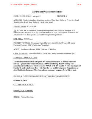
ZONING CHANGE REVIEW SHEET CASE: C14-99-2052.04 –Interport 2 DISTRICT: 2 ADDRESS: Northwest and northeast intersection of East State Highway 71 Service Road Westbound at South State Highway 130 Service Road ZONING FROM: LI-PDA-NP TO: LI-PDA-NP, to amend the Planned Development Area, known as Interport PDA (Ordinance No. 000928-24 & 25), to modify Exhibit F - Site Development Standards and Attachment Two - Site Specific Use and Development Regulations. SITE AREA: 363.19 acres PROPERTY OWNER: Stoneridge Capital Partners, Ltd. (Mitchel Wong); EP Austin Purchase Company LLC (Christopher Westphal) AGENT: Armbrust & Brown, PLLC (Michael J. Whellan) CASE MANAGER: Nancy Estrada (512-974-7617, nancy.estrada@austintexas.gov) STAFF RECOMMENDATION: The Staff recommendation is to grant the fourth amendment to limited industrial services – planned development area (LI-PDA) combining district zoning. The amendment would amend Ordinance No. 000928-24 & 25, Exhibit F - Site Development Standards and Attachment Two - Site Specific Use and Development Regulations, as described in the Proposed PDA Amendment summary on pages 3-4 of this report. ZONING & PLATTING COMMISSION ACTION / RECOMMENDATION: October 21, 2025: CITY COUNCIL ACTION: ORDINANCE NUMBER: ISSUES: None at this time. 05 C14-99-2052.04 - Interport 2; District 2 1 of 36 C14-99-2052.04 Page 2 CASE MANAGER COMMENTS: The Planned Development Area (PDA), known as Interport PDA, is located in East Austin, at the northwest and northeast corners of the intersection of East State Highway (SH) 71 Service Road Westbound and South State Highway (SH) 130 Service Road. The Interport PDA is approximately 363 acres with State Highway 130 bisecting the property. The planned development area consists of a mixed-use development that will provide multifamily residences and commercial uses primarily along East State Highway 71, and industrial uses along State Highway 130. There are also parks and open space integrated within the PDA area. The majority of the land is undeveloped, with the exception of Colorado Creek Apartments located along the western boundary on Dionda Lane. The Prado Apartments are currently being constructed across Dionda Lane. Single family residences and manufactured homes are to the west (I-SF-2; RR); the Velocity Crossing LI-PDA area is across SH 71 to the south (LI-PDA); the Onion Creek Wildlife Sanctuary Park is to the east (P); and undeveloped land along the Colorado River is to the north (DR). Please refer to Exhibits A (Zoning Map) and B (Aerial). The Applicant’s request is to change the conditions of the PDA overlay by amending Ordinance No. 000928-24 & 25 to modify Exhibit F - Site Development Standards and Attachment Two - Site Specific Use and Development Regulations for the Interport PDA. Please see Attachment A (Applicant’s Summary Letter and Proposed Redline for Ordinance No. 000928-24 & 25). The requested amendment would eliminate the required setbacks originally established in anticipation of the construction of SH 71 and SH 130. Since adoption of the original PDA ordinance, the State of Texas (TxDOT) has acquired over 14 acres within the property. As a result, the setback requirements are no longer needed. Additionally, the proposed amendment seeks to update the site development regulations to allow residential use to comply with multifamily residence highest density (MF-6) district standards and commercial uses to comply with general commercial services (CS) district standards. The Staff recommendation is to grant the applicant’s request to change the conditions of the Planned Development Area overlay by amending Ordinance No. 000928-24 & 25. The property’s location along SH 71 and SH 130, two major arterials, makes it well suited for a mix of residential and commercial development that will support the area’s continued growth and provide additional housing opportunities. It is also in alignment with the zoning in the surrounding area since there is LI-PDA zoning to the south across SH 71 with comparable site development regulations. 05 C14-99-2052.04 - Interport 2; District 2 2 of 36 C14-99-2052.04 Page 3 PROPOSED PDA AMENDMENT Amend Ordinance No. 000928-24 & 25 as follows: 1) Exhibit F – Site Development Standards Section B. Uses: B.2. will be revised to clarify Attachment 3 as the (Land Use Plan). B.3. language will be revised to replace ‘retail’ with ‘commercial’ uses. Section C. Site Development Regulations: C.1.b. (General Regulations) will modify the maximum building height from 60 feet to 90 feet. C.1.c. (General Regulations) will be revised to include retail, commercial, or mixed use development to comply with site development regulations applicable to the general commercial services (CS) district for minimum lot width, minimum setbacks, building coverage, impervious cover, and floor to area ratio. C.1.d. (General Regulations) will be revised for multifamily residential use to comply with the site development regulations for the multifamily residence highest density (MF-6) district as follows: 50 ft. Minimum lot width: 90 ft. Maximum height: 15 ft. Front yard setback: 15 ft. Street side yard: setback: 5 ft. Interior side yard setback: Rear yard setback: 10 ft. Maximum building coverage: 70% Maximum impervious cover: 80% Floor-to-area ratio: No maximum C.2.a. (Setback Requirements) will be removed since these setbacks were originally established in anticipation of SH 71 and SH 130 being completed and are no longer needed. C.2.a.1. (Setback Requirements) will be removed. C.2.a.2. (Setback Requirements) will be removed. C.2.b. (Setback Requirements) will remain and be renumbered accordingly. C.3.a. (Landscape buffers) will be removed. C.3.b. (Landscape buffers) will be removed. 05 C14-99-2052.04 - Interport 2; District 2 3 of 36 C14-99-2052.04 Page 4 All other sections of Exhibit F will be renumbered accordingly. 2) Attachment 1 – Use Table Permitted and prohibited uses to remain unchanged. 3) Attachment 2 – Site-Specific Use and Development Regulations 3. Block and Lot descriptions will be updated accordingly. 5. Language will be revised to MF-6. Block and Lot descriptions will be updated accordingly BASIS OF RECOMMENDATION: 1. The proposed zoning should be consistent with the purpose statement of the district sought. The limited industrial services (LI) district designation is for a commercial service use or limited manufacturing use generally located on a medium or large sized site. The planned development area (PDA) combining district designation provides for industrial and commercial uses in certain commercial and industrial base districts. 2. The proposed zoning should allow for a reasonable use of the property. The proposed amendment is appropriate for this area since it is located along two major arterial roadways, State Highway 71 and State Highway 130. These corridors have been significantly improved and will support future residential and commercial development in this area. 3. The proposed zoning should promote consistency and orderly planning. The Interport PDA zoning is compatible with surrounding land uses, as there is LI-PDA zoning directly south of the property across SH 71. The adjacent PDA currently allows development consistent with multifamily residence highest density (MF-6) district standards and general commercial services (CS) district standards. EXISTING ZONING AND LAND USES: ZONING LAND USES Site LI-PDA North N/A; DR South LI-PDA; N/A East P West I-SF-2; RR Undeveloped Colorado River; Undeveloped East SH 71; Velocity Crossing PDA; Austin ETJ Onion Creek Wildlife Sanctuary; Austin Energy/Sand Hill Energy Center Single family residences; Undeveloped 05 C14-99-2052.04 - Interport 2; District 2 4 of 36 C14-99-2052.04 Page 5 NEIGHBORHOOD PLANNING AREA: N/A WATERSHED: Onion Creek and Colorado River – Suburban CAPITOL VIEW CORRIDOR: No SCENIC ROADWAY: Yes – East SH 71 and South SH 130 SCHOOLS: Del Valle Independent School District Hornsby-Dunlap Elementary School Dailey Middle School Del Valle High School COMMUNITY REGISTRY LIST: Austin Neighborhoods Council Del Valle Community Coalition Non-Profit Dog’s Head Neighborhood Association Far Southeast Improvement Association Homeless Neighborhood Association Imperial Neighborhood Association Del Valle ISD Elroy Neighborhood Association Friends of Austin Neighborhoods Onion Creek HOA Overton Family Committee AREA CASE HISTORIES: NUMBER C14-2015-0117 – Velocity Crossing REQUEST DR; CS-CO; I-RR to LI-PDA COMMISSION To Grant LI-PDA, with conditions of the TIA. (3/1/2016) CITY COUNCIL Apvd LI-PDA as Commission recommended (4/14/2016) C14-2022-0175 – Airport 973 Addition C14-2019-0059 – SH 71 and FM 973 I-SF-2 to GR-CO To Grant GR-CO w/ CO for prohibited & conditional uses; established uses subject to LDC 25-2-587. (5/2/2023) To Grant GR-CO w/ RC for conditions of the NTA. (6/1/2021) I-SF-2; GR-CO to GR-CO Apvd GR-CO as Commission recommended (6/8/2023) Apvd GR-CO w/ RC for conditions of the NTA as Commission recommended (9/2/2021) 05 C14-99-2052.04 - Interport 2; District 2 5 of 36 C14-99-2052.04 RELATED CASES: Page 6 C14-00-2052 and C14-00-2053 – Council approved the Interport PDA which includes approximately 652 acres of land on September 28, 2000 (Ordinance No. 000928-24 & 25). The subject request is the fourth amendment, titled Interport 2, comprised of 363.19 acres. There were three previous applications to amend the Interport PDA: 1) Amendment #1: C14-99-2052(PDA) – Administratively approved amendment dated July 9, 2007 to modify the Land Use Plan to reflect the final South SH 130 alignment. 2) Amendment #2: C14-2021-0140 – Administratively approved amendment in October 2021 to revise the Land Use Plan. 3) Amendment #3: C14-2022-0108 – Administratively approved amendment dated December 14, 2023 to revise the Land Use Plan. ADDITIONAL STAFF COMMENTS: Comprehensive Planning Project Name and Proposed Use: 3301 E SH 71 SERVICE ROAD WB. C14-99-2052.04. Project: Interport 2. The applicant is requesting an amendment to a PDA. Existing: undeveloped. Proposed: multifamily. Note that this zoning amendment seeks to modify residential and commercial entitlements and site development setbacks in pursuit of increased densities through modification of the PDA ordinance. Yes Y Imagine Austin Decision Guidelines Complete Community Measures * Imagine Austin Growth Concept Map: Located within or adjacent to an Imagine Austin Activity Center, Imagine Austin Activity Corridor, or Imagine Austin Job Center as identified the Growth Concept Map. Names of Activity Centers/Activity Corridors/Job Centers *: • 0.50 miles from Rio di Vida Town Center Mobility and Public Transit *: Located within 0.25 miles of public transit stop and/or light rail station. Y Mobility and Bike/Ped Access *: Adjoins a public sidewalk, shared path, and/or bike lane. • Sidewalk present along Fallwell LN, but limited elsewhere Connectivity, Good and Services, Employment *: Provides or is located within 0.50 miles to goods and services, and/or employment center. Connectivity and Food Access *: Provides or is located within 0.50 miles of a grocery store/farmers market. Connectivity and Education *: Located within 0.50 miles from a public school or university. Connectivity and Healthy Living *: Provides or is located within 0.50 miles from a recreation area, park or walking trail. Connectivity and Health *: Provides or is located within 0.50 miles of health facility (ex: hospital, urgent care, doctor’s office, drugstore clinic, and/or specialized outpatient care.) Y Housing Choice *: Expands the number of units and housing choice that suits a variety of household sizes, incomes, and lifestyle needs of a diverse population (ex: apartments, triplex, granny flat, live/work units, cottage homes, and townhomes) in support of Imagine Austin and the Strategic Housing Blueprint. Housing Affordability *: Provides a minimum of 10% of units for workforce housing (80% MFI or less) and/or fee in lieu for affordable housing. Y Mixed use *: Provides a mix of residential and non-industrial uses. Culture and Creative Economy *: Provides or is located within 0.50 miles of a cultural resource (ex: library, 05 C14-99-2052.04 - Interport 2; District 2 6 of 36 C14-99-2052.04 Page 7 theater, museum, cultural center). Culture and Historic Preservation: Preserves or enhances a historically and/or culturally significant site. Creative Economy: Expands Austin’s creative economy (ex: live music venue, art studio, film, digital, theater.) Workforce Development, the Economy and Education: Expands the economic base by creating permanent jobs, especially in industries that are currently not represented in a particular area or that promotes a new technology, and/or promotes educational opportunities and workforce development training. Industrial Land: Preserves or enhances industrial land Y Not located over Edwards Aquifer Contributing Zone or Edwards Aquifer Recharge Zone 5 Number of “Yes’s” Airport Overlay The site is located within Austin-Bergstrom Overlay {Controlled Compatible Land Use Area}. No use will be allowed that creates electrical interference with navigational signals or radio communications between airport and aircraft, makes it difficult for pilots to distinguish between the airport lights and others, results in glare in the eyes of pilots using the airport, impairs visibility in the vicinity of the airport, creates bird strike hazards or otherwise in any way endanger or interfere with the landing, taking off, or maneuvering of aircrafts intending to use the Austin-Bergstrom Airport. Height limitations and incompatible uses with each Airport Overlay zone are established in the Airport Overlay Ordinance. Environmental No comments. Approved. PARD – Planning & Design Review Parkland dedication will be required for the new applicable uses proposed by this development, multifamily and commercial with PDA zoning, at the time of subdivision or site plan, per City Code § 25-1-601. Whether the requirement shall be met with fees in-lieu or dedicated land will be determined using the criteria in City Code Title 25, Article 14, as amended. Should any fees in-lieu be required, those fees shall be used toward park investments in the form of land acquisition and/or park amenities within the surrounding area, per the Parkland Dedication Operating Procedures § 14.3.11 and City Code § 25-1-609. Unless otherwise requested and approved via the City’s Project Review Form, projects associated with this PDA will be reviewed under the current parkland ordinance. If the applicant wishes to discuss parkland dedication requirements in advance of site plan or subdivision applications, please contact this reviewer: ann.desanctis@austintexas.gov. At the applicant’s request, PARD can provide an early determination of whether fees in-lieu of land will be allowed. 05 C14-99-2052.04 - Interport 2; District 2 7 of 36 C14-99-2052.04 Site Plan Page 8 No site plan comments at this time. Site plan comments will be provided at time of formal site plan submittals. Austin Fire Department No comments. Approved. Transportation – Engineering Review This site must demonstrate compliance with the TIA and traffic phasing agreement approved with the Interport PDA Zoning Case, approved by City Council on September 28, 2000. A Traffic Phasing Agreement Compliance Memo was submitted and approved on August 1, 2025. Austin Water Utility No comments on zoning change. The landowner intends to serve the site with City of Austin water, reclaimed, and wastewater utilities. The landowner, at own expense, will be responsible for providing any water, reclaimed, and wastewater utility improvements, offsite main extensions, utility relocations and or abandonments required by the land use. The water, reclaimed, and wastewater utility plan must be reviewed and approved by Austin Water for compliance with City criteria and suitability for operation and maintenance. Service Extension Requests have been approved for this site. Depending on the development plans submitted, further water, reclaimed, and or wastewater Service Extension Requests may be required. For more information pertaining to the Service Extension Request process and submittal requirements contact the Austin Water SER team at ser@austintexas.gov. All new development within the proposed project will be subject to City Code Chapter 25-9 and any future amendments relating to reclaimed water connections, water benchmarking, and mandatory onsite water reuse. All water, reclaimed, and wastewater construction must be inspected by the City of Austin. The landowner must pay the City inspection fee with the utility construction. The landowner must pay the tap and impact fee once the landowner makes an application for a City of Austin water, reclaimed, and wastewater utility tap permit. 05 C14-99-2052.04 - Interport 2; District 2 8 of 36 C14-99-2052.04 Page 9 INDEX OF EXHIBITS AND ATTACHMENTS TO FOLLOW: Exhibit A: Zoning Map Exhibit B: Aerial Map Attachment A: Applicant’s Summary Letter with proposed red-lined Site Development Standards for Ordinance No. 000928-24 & 25 Attachment B: Ordinance No. 000928-24 & 25 05 C14-99-2052.04 - Interport 2; District 2 9 of 36 R A D R A L E R E D L A K SP-05-1735D C12M-2018-0005 SP-04-0163D COUNTY C12M-2018-0005 B N 0 3 1 H S S B S 0 3 1 H S S ! ! ! ! L L N ! ! L W E ! ! L ! L F A ! ! ! ! E S H 7 1 T O S I-RR ! ! ! ! ! ! ! ! ! ! ! ! ! ! ! ! ! LI-PDA ! ! ! ! ! ! ! ! ! ! ! ! ! ! ! ! ! ! ! ! ! ! ! ! ! P C14-2017-0012 P P C14-2013-0024 C7A-07-012 ! ! ! ! ! ! ! ! ! ! ! C7A-05-015 20051201-021 ! ! ! ! SP-2007-0411D ! ! LI-PDA ! C14-2022-0108 ! ! ! ! ! ! ! ! ! ! ! ! ! ! ! ! ! ! ! SP-2007-0408D ! ! ! ! ! ! ! ! ! ! ! ! ! ! ! ! ! ! ! SP-04-1031D DR AUTO SALVAGE D R 3 7 9 M F S COLORADO RIVER DR I-RR BAR 00-2002 MH MIC H O A C A N D R ( ( MH MH MH MH MH MH I-SF-2 MH MH MH I-SF-2 MH P U MH MH MH MH MH MH MH E B L M H A D R MH ( ( ( MH I-SF-2 ( ( MH ( MH ( ( ( ( I-SF-2 ( ( ( ( E L L ( ( ( ( N O ( ( R D ( ( ( ( ( I-SF-2 ( ( ( ( I-SF-2 ( ( ( ( ( ( ( C14-2019-0094 ( ( ( LO-CO ( ( C14-2008-0232 R O Y STE R AV E ( ( ( ( C14-2018-0036 ( ( E V A S ( T ( ( I-SF-2 ( ( ( ( I-SF-2 ( ( ! ! ! I-RR ! P ! C14-06-0222 ! ! ! ! GR ( ( ( ( M LR-CO C14-2008-0235 ( I-SF-2 ( ( ( ( ( A S V E T RR I-SF-2 ( ( ( S ( T Y A ( R ( I-SF-2 ( ( ( ( C14-2022-0175 C14-01-0075 ( ( C14-2019-0059 ( I-SF-2 ( ( ( ( ( GR-CO ( ( ( ( LR I-SF-2 C14-2014-0197 ! E S I-RR H 71 S GR-CO V R D E B ! C H U R C H P-CO C14-05-0070 SP-06-0151C P C14-2009-0061 C14-2017-0057 CS-CO C14-06-0208 06-0208 UNDEV C14-2011-0048 Y M WA TU N E M O M 00-2002 ! ! I-SF-2 ! ! ! ! ! ! ! ! ! ! ! ! ! ! ! ! ! ! ! ! ! ! ! ! ! ! ! ! ! ! LI-PDA ! ! ! ! ! ! ! ! ! ! ! ! ! ! ! ! ! ! ! ! ! ! ! ! ! ! ! ! ! C14-00-2053 ! ! ! ! ! ! ! ! ! ! ! ! ! ! ! ! ! ! ! ! ! ! LI-PDA ! ! ! ! ! ! ! C14-2022-0108 ! 99-2053 ! ! ! ! 99-2052 ! ! ! ! ! ! ! ! ! ! ! ! ! ! ! ! ! ! ! ! ! ! ! ! ! ! ! ! ! C7L-00-003 ! ! ! ! ! ! ! ! ! ! ! ! ! ! ! ! S H 1 3 0 N B R A M P P M A R 1 7 H S E O T B S 0 3 1 H S S ! ! MELAS DR ! ! ! ! ! ! ! ! ! MH ! ! ! DIONDA LN ! ! ! ! ! ! ! ! ! ! UNDEV ! ! E S ! ! H 71 W B ! ! ! ! ! ! ! ! ! D LV RIS B A LIV O ! ! E B 7 1 T O E ! ! ! C14-99-2053 ! ! ! ! ! ! ! E SH 71 SVR ! ! ! ! D W B B 7 1 S V R D A ! ! ! ! ! LI-PDA ! ! ! ! ! ! ! ! ! ! ! ! ! ! ! ! ! ! C14-2021-0140 ! C14-99-2052 ! ! ! ! ! ! ! ! ! ! ! ! ! ! ! ! ! ! ! ! T F A E S L L W H 7 E 1 E L L R B T O S S A M P H 1 3 0 N B R A M P ! ! ! !! ! ! ! ! ! ! ! ! ! C A N V A S L N S PIRIT D R G Y XIN CIT O L E V ! ! ! ! ! ! ! ! ! ! ! ! ! ! ! ! ! ! ! ! ! ! ! ! ! ! ! ! ! ! ! ! ! ! ! ! ! ! ! UNDEV LI-PDA C14-2015-0117 E S H 7 1 E B LI-CO C14-02-0013 3 3 B D N R V 0 S P M H 1 A 1 R S S H 7 O E S B T 0 N H 1 S S P M A B R B D S 0 S R V H 1 0 S O S S H 1 S S 1 T H 7 E S 3 3 ± SUBJECT TRACT ! ! ! ! ! ! PENDING CASE ZONING BOUNDARY ZONING ZONING CASE#: C14-99-2052.04 EXHIBIT A This product is for informational purposes and may not have been prepared for or be suitable for legal, engineering, or surveying purposes. It does not represent an on-the-ground survey and represents only the approximate relative location of property boundaries. 1 " = 1,200 ' This product has been produced by the Planning Department for the sole purpose of geographic reference. No warranty is made by the City of Austin regarding specific accuracy or completeness. Created: 4/8/2025 05 C14-99-2052.04 - Interport 2; District 2 10 of 36 EXHIBIT B !!!!!!!!!!!!!!!!!!!!!!!!!!!!!!!!!!!!!!!!!!!!!!!!!!!!!!!!!!!!!!!!!!!!!!!!!!!!!!!!!!!!!!!!!!!!!!!!!!!!!!!!!!!!!!!!!!!!!!!!!!!!!!!!!!!!!!!!!!!!!!!!!!!!!!!!!!!!!!!!!!!!!!!!!!!!!!!!!!!!!!!!!!!!!!!!!!!!!!!!!!!!!!!!!!!!!!!!!!!!!!!!!!!!!!!!!!!!!!!!!!!!!!!!!!!!!!!!!!!!!!!!!!!!!!!!!!!!!!!!!!!!!!!!!!!!!!!!!!!!!!!!!!!!!!!!!!!!!!!!!!!!!!!!!!!!!!!!!!!!!!!!!!!!!!!!!!!!!!!!!!!!!!!!!!!!!!!!!!!!!!!!!!!!!!!!!!!!!!!!!!!!!!!!!!!!!!!!!!!!!!!!!!!!!!!!!!!!!!!!!!!!!!!!!!!!!!!!!!!!!!!!!!!!!!!!!!!!!!!!!!!!!!!!!!!!!!!!!!!!!!!!!!!!!!!!!!!!!!!!!!!!!!!!!!!!!!!!!!!!!!!!!!!!!!!!!!!!!!!!!!!!!!!!!!!!!!!!!!!!!!!!!!!!!!!!!!!!!!!!!!!!!!!!!!!!!!!!!!!!!!!!!!!!!!!!!!!!!!!!!!!!!!!!!!!!!!!!!!!!!!!!!!!!!!!!!!!!!!!!!!!!!!!!!!!!!!!!!!!!!!!!!!!!!!!!!!!!!!!!!!!!!!!!!!!!!!!!!!!!!!!!!!!!!!!!!!!!!!!!!!!!!!!!!!!!!!!!!!!!!!!!!!!!!!!!!!!!!!!!!!!!!!!!!!!!!!!!!!!!!!!!!!!!!!!!!!!!!!!!!!!!!!!!!!!!!!!!!!!!!!!!!!!!!!!!!!!!!!!!!!!!!!!!!!!!!!!!!!!!!!!!!!!!!!!!!!!!!!!!!!!!!!!!!!!!!!!!!!!!!!!!!!!!!!!!!!!!!!!!!!!!!!!!!!!!!!!!!!!!!!!!!!!!!!!!!!!!!!!!!!!!!!!!!!!!!!!!!!!!!!!!!!!!!!!!!!!!!!!!!!!!!!!!!!!!!!!!!!!!!!!!!!!!!!!!!!!!!!!!!!!!!!!!!!!!!!!!!!!!!!!!!!!!!!!!!!!!!!!!!!!!!!!!!!!!!!!!!!!!!!!!!!!!!!!!!!!!!!!!!!!!!!!!!!!!!!!!!!!!!!!!!!!!!!!!!!!!!!!!!!!!!!!!!!!!(!(!(!(!(!(!(!(!(!(!(!(!(!(!(!(!(!(!(C14-99-2052.04C14-99-2052.04C14-99-2052.04C14-99-2052.04C14-99-2052.04C14-99-2052.04C14-99-2052.04C14-99-2052.04C14-99-2052C14-99-2053C14-2015-0117C14-2021-0140C14-2013-0024C12M-2018-0005C14-2022-0108C14-2022-0108C14-2017-0012C14-00-2053C14-2013-0024C12M-2018-0005C14-2011-0048C14-06-0208C14-2014-0197ESH71EBS SH 130 SBS SH 130 NBESH71WBFALLWELLLNS SH 130 SVRD NBS SH 130 SVRDSBESH71SVRDEBESH71SVRDWBDIONDALNOLIVARISBLVDSPIRITDRCANVASLNMELAS DRE SH 71 EB TO S SH 130 NB RAMPPUEBLADRGUERRERO DRE SH 71 TO S SH 130 NB RAMPE SH 71 TO SSH 130 SB RAMPEB71TOEB71SVRDATFALLWELLRAMPMARYSTS SH 130 NB TOE SH 71 RAMPS SH 130 SB TO E SH 71 RAMPMOMENTUMWAYSSH130SVRDSBTOSH71RAMPBESSIEAVEWB71SVRDTOWB71ATFALLWELLRAMPMICHOACANDRS SH 130 NB AT FALLWELL LN TRNEVASTMORELOSCVPLI-PDALI-PDALI-PDAPDRPLI-PDALI-PDAI-SF-2RRRRI-SF-2I-SF-2I-SF-2LI-PDAI-SF-2I-RRI-RRI-SF-2LRInterport 2±This product has been produced by Planning Department for the sole purpose of geographic reference. No warranty ismade by the City of Austin regarding specific accuracy or completeness.ZONING CASE#:LOCATION:SUBJECT AREA:MANAGER:C14-99-2052.04NW & NE corners ofSH 71 & SH 130363.19 AcresNancy EstradaCreated: 7/8/2025SUBJECT TRACTZONING BOUNDARY!!!!!PENDING CASECREEK BUFFER1 inch equals 900 '05 C14-99-2052.04 - Interport 2; District 2 11 of 36 ATTACHMENT A ARMBRUST & BROWN, PLLC A T T O R N E Y S A N D C O U N S E L O R S 100 CONGRESS AVENUE, SUITE 1300 AUSTIN, TEXAS 78701-2744 512-435-2300 FACSIMILE 512-435-2360 March 1, 2025 Joi Harden, Zoning Officer City of Austin Housing and Planning Department 1000 E. 11th St. Austin, Texas 78702 Re: Planned Development Area (“PDA”) amendment rezoning for the property described in Ordinance No. 000928-24 & 25, also known as Interport PDA (the “Property”) Dear Ms. Harden, On behalf of Stoneridge Capital Partners, Ltd. (“Stoneridge”) and EP Austin Purchase Company, LLC (“EP Austin”) (collectively, the “Applicants”), please accept the attached application requesting that the city amend 363.19 acres of Interport PDA (Zoning Case Nos. C14-99-2052 and C14-99-2053, Ordinance Nos. 000928-24 & 25). The requested amendments would eliminate the required setbacks established in 1999, which were set in anticipation of the build-out of State Highways 71 and 130. Since the passage of the Ordinance Nos. 000928-24 & 25 (the “Original PDA Ordinance”), the State of Texas has come to own over 14 acres on the Property under the authority granted to it under the Texas Transportation Code. As a result, the setbacks established in the Original PDA Ordinance are no longer needed and the Property wishes to develop under the same regulations as any other property adjacent to public right-of-way. A public restrictive covenant (“PRC”) was filed with the Original PDA Ordinance further codifying the right- of-way reservation under Inst. No. 2000172280. The PRC reserved 175 ft. of right-of-way from the centerline of State Highway 71 East for future expansion. That expansion has since occurred, with the actual right-of-way generally appearing to have exceeded the 175 ft. buffer from the centerline. The PRC allows city staff to administratively terminate the restriction upon request from the property owner. Please accept this letter as the Applicants’ request to administratively terminate the restrictive covenant. Additionally, the requested amendment seeks to update the 25-year-old development regulations to increase the Property’s residential and commercial entitlements. Attached, you will find a traffic phasing compliance memo demonstrating that the project remains consistent with the analysis and recommendations from the previously approved traffic impact analysis (“TIA”). The Land Use Plan for the Property has been administratively amended under cases C14-2021-0140 and C14-2022-0108. For your reference, I am attaching the staff memo administratively approving the amended land use plan complete with the approved land use plan exhibit and the approved redline of Attachment 2 of Exhibit F of the Original PDA Ordinance. Using the administratively approved documents as the base document, I am attaching a redline of Exhibit F with our proposed amendments. I am also attaching an amending ordinance reflecting the changes to Exhibit F of the Original PDA Ordinance. Finally, for reference purposes, I am including a table showing the affected tracts and acreage as established by the administratively approved land use plan. The second page of that document contains more information for each tract included in our rezoning application, such as the corresponding deeds, subdivisions, and designated land use under the land use plan. Thank you for your time and consideration. Please contact me if you have questions about this application or if you need additional information. Respectfully, Michael J. Whellan 05 C14-99-2052.04 - Interport 2; District 2 12 of 36 Exhibit F SITE DEVELOPMENT STANDARDS A. Applicability of Title 25 of the City Code. Except as otherwise provided in these Site Development Standards, development of the Property shall comply with Title 25 of the City Code. B. Uses 1. 2. Permitted and prohibited uses are established in Attachment 1 (Use Table) and Attachment 2 (Site Specific Use and Development Regulations) of these Site Development Standards. The location of uses is shown in Attachment 3 (Conceptual Plan). An applicant may submit a request to the Director of the Development Review and Inspection Department to shift the uses identified in the Conceptual Plan within the plan area. The director may approve the request if the change would not constitute a substantial amendment under Section 25-2-403 of the City Code (Land Use Plan Expiration and Amendment). A request to shift the uses must be submitted in accordance with Section 25-2-403(C)(1) of the City Code. A decision on the request may be appealed in accordance with Section 25-2-403(C)(2) of the City Code. 3. When fully developed, the Property shall contain a minimum of 1,500 dwelling units and a minimum of 500,000 square feet of commercialretail uses. C. Site Development Regulations. Except as provided in Attachment 2 (Site Specific Use and Development Regulations), the following regulations apply to development of the Property: 1. General Regulations. a. b. Except as otherwise provided in Section C.1., development of the Property shall comply with the site development regulations applicable to the limited industrial service (LI) district. Except as otherwise provided in Section C.1.c., the maximum building height on the Property is 60 feet 90 feet. c. Development of a rRetail, commercial, or mixed use development shall comply with the site development regulations applicable to the community commercial (GR) general commercial services (CS) district for minimum lot width, maximum height, minimum setbacks, building coverage, impervious cover, and floor to area ratio. 05 C14-99-2052.04 - Interport 2; District 2 13 of 36 d. Development of a multifamily residential use shall comply with the site development regulations for the multifamily residence highestmedium density (MF-6) (MF-3) district in accordance with Section 25-2-492 of the City Code and as follows: Minimum lot width: 50 ft. Maximum height: 90 ft. Front yard setback: 15 ft. Street side yard: setback: 15 ft. Interior side yard setback: 5 ft. 10 ft. Rear yard setback: Maximum building coverage: 70% Maximum impervious cover: 80% Floor-to-area ratio: No maximum e. The property described in Zoning Case File Nos. C14-99-2052 and C14-99-2053 are a single site for all purposes under Chapter 25-2 of the City Code. f. Multiple site plans may be submitted for development on the Property. Development within the Property may be phased. 2. Setback Requirements a. The minimum setback from the property line adjacent to State Highway 71 is 125 feet. If land adjacent to State Highway 71 is acquired for expansion of State Highway 71 before October 9, 2010, the minimum setback from the property line adjacent to State Highway 71, as expanded, is 50 feet. If land is not acquired for right-of-way on or before October 9, 2010, and the Director of the Development Review and Inspection Department modifies or terminates the right-of-way reservation requirement under the terms of a restrictive covenant concerning right-of-way reservation on the Property, the minimum setback is: 1. 50 feet from the land reserved for right-of-way as modified by the restrictive covenant; or 2. 50 feet from the property line, if the restrictive covenant is terminated. b.a. If an industrial use is established on a lot that is adjacent to or across the street from property used for a residential use, the minimum setback from the lot line adjacent to or across from the residential use is 100 feet. 3. Landscape Buffers 05 C14-99-2052.04 - Interport 2; District 2 14 of 36 a. A landscape buffer shall be maintained in the area located more than 75 feet and less than 110 feet from the existing property line adjacent to State Highway 71. If land adjacent to State Highway 71 is acquired for expansion of State Highway 71 a minimum 35-foot landscape buffer shall be maintained along the property line adjacent to State Highway 71, as expanded. b. A minimum 50-foot landscape buffer shall be maintained along the property line adjacent to Falwell Lane if the land located along Falwell Lane across from the Property is zoned or used for a residential use. 4.3. Open Space. Development of the Property shall comply with the open space requirements of Section 25-2-411(K) (Planned Unit Development District Regulations) of the City Code. 5.4. Driveway Servicing an Industrial or Commercial Use a. A driveway that services an industrial or commercial use may not be located directly across the street from or less than 100 feet from a residential use unless: 1. 2. 3. the residential use is located in a building that includes non-residential uses on the ground floor; the driveway provides access to Block G; or the driveway is approved by the Director of the Development Review and Inspection Department. b. When reviewing a request to approve the location of a driveway under Section C.53.a.3., the Director of the Development Review and Inspection Department shall consider traffic patterns and noise and visual impacts. 6.5. Traffic Issues. Development of the Property shall be consistent with the projected uses and intensities assumed in the traffic impact analysis (TIA) prepared by Alliance-Texas Engineering Company, dated September 15, 1999, and is subject to the recommendations contained in the memorandum from the transportation review section of the Development Review and Inspection Department, dated May 31, 2000. The director of the Development Review and Inspection Department may approve an update or amendment of the TIA. 7.6. Water Quality Issues. 05 C14-99-2052.04 - Interport 2; District 2 15 of 36 a. Except for Section C.75.d., if an impervious cover regulation in these Site Development Regulations conflicts with a regulation in Chapter 25-8 of the City Code, the more restrictive regulation governs. b. Cut and Fill 1. Fill on the Property may not exceed eight feet of depth, except: (i) under a foundation with sides perpendicular to the ground, or with pier and beam construction if the fill is placed in a manner consistent with City regulations; or (ii) for backfill for utility construction 2. Cuts on the Property may not exceed eight feet of depth, except: (i) in a roadway right-of-way; (ii) for construction of a building foundation; or (iii) for utility construction or a wastewater drain field, if the area is restored to natural grade. Section C.63.b.2. does not apply to cuts for private or public roads or driveways where structural side-slope stabilization (containment) is proposed. Cut and fill for a roadway must be contained within allowable roadway clearing widths established by the City Code. 3. 4. 5. A cut or fill area must be restored and stabilized. c. Stream Bank Protection. 1. 2. Plans for stream bank erosion, including cut and fill, may be approved administratively. The stream bank of the Colorado River is defined by the metes and bounds description in Attachment 4. d. Water Quality Transition and Critical Zones. 1. Impervious cover in the water quality transition zone located within an individual development on the Property may exceed 30 percent of net site area as long as impervious cover in the entire water quality transition zone on the Property does not exceed 30 percent of net site area. Each application for 05 C14-99-2052.04 - Interport 2; District 2 16 of 36 a site plan covering development of the Property must include a table showing the existing impervious cover in the entire water quality transition zone on the Property and the impervious cover added by the proposed development included in the site plan. 2. The critical water quality zone along the Colorado River is the area that is 100 feet or less from the stream bank defined in Attachment 4. 8.7. Stormwater Detention. Stormwater detention for flood control purposes is not required because of Property’s proximity to the Colorado River. Stormwater from the Property shall be released through velocity control structures when protection of the natural and traditional character of land and waterways is required because of increased velocities for the 2-year storm. The velocity control structures shall be designed as part of the site development construction plan. 9.8. Floodplain Modifications. Floodplain and stream bank modifications along the Colorado River and Onion Creek may be approved administratively by the Director of Watershed Protection if the Director finds that the modifications provide equal or greater benefit to the surrounding waterways through the use of best management practices approved by the Director. The application shall submit a full environmental assessment and engineering study with a request for a floodplain or stream bank modification. The impervious cover limit for land removed from the floodplain as a result of an approved modification is the same as the impervious cover limit applicable to adjacent land. D. Conceptual Plan The blocks and tracts identified on the Conceptual Plan (Attachment 3) are conceptual and may require minor adjustment. The areas shall be verified and may be adjusted administratively at the time of final plat. Land that is not included in a block or tract because of the movement of SH 130 shall assume the use category of adjacent land. 05 C14-99-2052.04 - Interport 2; District 2 17 of 36 ATTACHMENT 1 USE TABLE A. PERMITTED USES Except as modified by Attachment 2, the following uses are permitted uses on the Property: Uses Permitted in LI District Condominium Residential Group Residential Multifamily Residential Retirement Housing (small site) Retirement Housing (large site) Two-Family Residential Carriage Stable Cocktail Lounge Consumer Repair Services Marina Pet Services Recreational Equipment Sales Research Assembly Services Research Testing Services Research Warehousing Services Stables Administrative Services Research Services and Maintenance Storage B. PROHIBITED USES Adult-Oriented Business Cemetery Military Installations Aviation Service Camp Convalescent Services Convention Center Guidance Services Hospital Services (general) Hospital Services (limited) Major Utility Facilities Major Public Facilities Postal Facilities Park and Recreation Services (specific) Park and Recreation Services (general) Private Primary Educational Facilities Private Secondary Educational Facilities Public Primary Educational Facilities Public Secondary Educational Facilities Animal Production Crop Production Horticulture Support Housing Scrap and Salvage Services Stockyards 05 C14-99-2052.04 - Interport 2; District 2 18 of 36 ATTACHMENT 2 SITE-SPECIFIC USE AND DEVELOPMENT REGULATIONS 1. 2. 3. 4. 5. 6. The following uses are prohibited on Lots 1 and 2 of Block G and that portion of Lot 2 of Block F located 300 feet or less from the Colorado River: research assembly services, research testing services, research warehousing services, major utility facilities, aviation facilities, automobile rentals, automotive repair services, automotive sales, automotive washing (of any type), dry cleaning, and any use that stores, produces or utilizes hazardous materials. The following uses are prohibited on property located 500 feet or less from Onion Creek: automotive rentals, automotive repair services, automotive sales, automotive washing (of any type), and dry cleaning. A use that stores, produces or utilizes hazardous materials is prohibited within the water quality transition zone of Onion Creek. The maximum height of development on Block C and Lot 1 of Block I is 75 feet. The following regulations apply to development of an industrial use on Block A, Block C, Lot 6 of Block H, and a portion of Lot 1 of Block I: a. each building used for an industrial use must include an office use; b. an office use included in a building with an industrial use must have a minimum floor area of 20 percent of the total building floor area or 1,000 square feet, whichever is less; c. a truck loading dock may not be located on the side of the building that faces State Highway 71; and d. an office use included in a building with an industrial use must face State Highway 71. Site development standards and permitted uses for the multifamily residence medium highest density (MF-36) district apply to Block B, and Tract 1 of Block F and a portion of Lot 1 and Lot 2 of Block G. The following site development standards apply to development on a portion of Lot 1 and Lot 2 of Block G and the portion of Lot 2 of Block F that is 300 feet or less from the Colorado River: a. the maximum impervious cover is 50 percent; and b. the maximum floor-to-area ratio is 0.6:1. 7. Except as otherwise provided in this Section 7, a permanent structure may not he constructed in the floodplain that exists after City-approved floodplain modifications have 05 C14-99-2052.04 - Interport 2; District 2 19 of 36 been constructed. The following permanent structures may be constructed in the floodplain in accordance with City floodplain regulations: utilities, uses permitted in the rural residence (RR) district, community recreational uses (public and private), and driveways. This provision is not a variance of floodplain regulations. 05 C14-99-2052.04 - Interport 2; District 2 20 of 36 ATTACHMENT B ORDINANCE NO. 000928-24 & 25 AN ORDINANCE ESTABLISHING INITIAL PERMANENT ZONING, REZONING, AND CHANGING THE ZONING MAP ACCOMPANYING CHAPTER 25-2 OF THE CITY CODE AS FOLLOWS: 652 ACRES OF LAND, MORE OR LESS, OUT OF THE SANTIAGO DEL VALLE SURVEY NO. 24, FROM DEVELOPMENT RESERVE (DR) DISTRICT, INTERIM SINGLE FAMILY RESIDENCE STANDARD LOT (LSF-2) DISTRICT AND INTERIM RURAL RESIDENCE (I-RR) DISTRICT TO LIMITED INDUSTRIAL SERVICES-PLANNED DEVELOPMENT AREA (LLPDA) COMBINING DISTRICT, GENERALLY KNOWN AS THE INTERPORT PDA, LOCALLY KNOWN AS THE PROPERTY LOCATED AT FALWELL LANE AT STATE HIGHWAY 71 EAST, IN THE CITY OF AUSTIN, TRAVIS COUNTY, TEXAS. BE IT ORDAINED BY THE CITY COUNCIL OF THE CITY OF AUSTIN: PART 1. The zoning map established by Section 25-2-191 of the City Code is amended to interim single family change the base district from development reserve (DR) district, residence standard lot (I-SF-2) district, and interim rural residence (I-RR) district to limited industrial service-planned development area (LI-PDA) combining district on the property described in Files Cl 4-00-2052 and Cl 4-00-2053, as follows: Tract 1 : A 27.434 acre tract of land out of the Santiago Del Valle 10 League Grant in Travis County, the tract of land being more particularly described by metes and bounds in Exhibit “A" incorporated into this ordinance, and Tract 2: A 5.913 acre tract of land out of the Santiago Del Valle 10 League Grant in Travis County, the tract of land being more particularly described by metes and bounds in Exhibit “B” incorporated into this ordinance, and Tract 3: A 17.657 acre tract of land out of the Santiago Del Valle 10 League Grant in Travis County, the tract of land being more particularly described by metes and bounds in Exhibit “C” incorporated into this ordinance, and Tract 4: A 600.587 acre tract of land out of the Santiago Del Valle 10 League Grant in Travis County, the tract of land being more particularly described by metes and bounds in Exhibit “D” incorporated into this ordinance, (the “Property”) Page 1 of 2 05 C14-99-2052.04 - Interport 2; District 2 21 of 36 generally known as the Interport PDA, locally known as the property located at Fallwell Lane at State Highway 71 East, in the City of Austin, Travis County, Texas, and as more particularly identified in the map attached as Exhibit “E”. PART 2. The Property within the boundaries of the Planned Development Area combining district established by this ordinance shall conform to the site development standards as set forth in the “Site Development Standards” attached as Exhibit “F” to this ordinance. Except as specifically modified under this ordinance, the Property may be developed and used in accordance with the regulations established for the Limited Industrial Services (LI) base district and other applicable requirements of the City Code. PART 3. The Council waives the requirements of Section 2-2-3, 2-2-5, and 2-2-7 of the City Code for this ordinance. PART 4. This ordinance takes effect on October 9, 2000. PASSED AND APPROVED September 28 2000 § 7 I J 1 Kirk Watson Mayor Page 2 of 2 05 C14-99-2052.04 - Interport 2; District 2 22 of 36 05 C14-99-2052.04 - Interport 2; District 2 23 of 36 Exhibit F site: development standards A. Applicability of Title 25 of the City Code. Except as otherw ise provided in these Site Development Standards, development of the Property shall comply with Title 25 of the City Code. B. Uses. 1. 2. Permitted and prohibited uses are established in Attachment 1 (Use Table) and Attachment 2 (Site Specific Use and Development Regulations) of these Site Development Standards. The location of uses is shown in Attachment 3 (Conceptual Plan). An applicant may submit a request to the Director of the Development Review and Inspection Department to shift the uses identified in the Conceptual Plan within the plan area. The director may approve the request if the change w ould not constitute a substantial amendment under Section 25-2-403 of the City Code (Land Use Plan Expiration and Amendment). A request to shift the uses must be submitted in accordance with Section 25-2-403( C )( 1 ) of the City Code. A decision on the request may be appealed in accordance with Section 25-2-403(0(2) of the City Code. 3 When fully developed, the Property shall contain a minimum of 1.500 dwelling units and a minimum of 500.000 square feet of retail uses. C. Site Development Regulations. Except as otherwise provided in Attachment 2 (Site Specific Use and Development Regulations), the following regulations apply to development of the Property. 1. General Regulations. a. b. c. Except as otherw ise provided in Section C. 1. development of the Property shall comply with the site development regulations applicable to the limited industrial service (El) district. FAcept as otherwise provided in Section C.1 .c.. the maximum building height on the Property is 60 feet. Development of a retail use shall comply with the site development regulations applicable to the community commercial (GR) district for minimum lot width, maximum height, minimum setbacks, building coverage, impervious cover, and floor to area ratio. Interport SDS - '"U: ..U 05 C14-99-2052.04 - Interport 2; District 2 24 of 36 d. e. f. Development of a multifamily residential use shall comply with the site development regulations for the multifamily residence medium density (MF-3) district. Ihe property described in Zoning Case File Nos. Cl 4-99-2052 and Cl 4-99-2053 are a single site for all purposes under Chapter 25-2 of the City Code. Multiple site plans may be submitted for development on the Property. Development w ithin the Property may be phased. 2. Setback Requirements. a. I'he minimum setback from the property line adjacent to State Highway 71 is 125 If land adjacent to State Highway 71 is acquired for expansion of State feet. Highway 71 before October 9, 2010, the minimum setback from the property line adjacent to State Highway 71. as expanded, is 50 feet. If land is not acquired for right-of-way on or before October 9. 2010. and the Director of the Development Review and Inspection Department modifies or terminates the right-of-way reservation requirement under the terms of a restrictive covenant concerning right-of-way reservation on the Property, the minimum setback is: 1 . 2. 50 feet from the land reserved for right-of-way as modified by the restrictive covenant; or 50 feet from the property line, if the restrictive covenant is terminated. b. If an industrial use is established on a lot that is adjacent to or across the street from property used for a residential use. the minimum setback from the lot line adjacent to or across from the residential use is 100 feet. 3. Landscape Buffers. a. b. A landscape buffer shall be maintained in the area located more than 75 feet and If less than 1 10 feet from the existing property line adjacent to State Highway 71. land adjacent to State Highway 71 is acquired for expansion of State Highway 71 a minimum 35-foot landscape buffer shall be maintained along the property line adjacent to State Highway 71. as expanded. A minimum 50-foot landscape buffer shall be maintained along the property line adjacent to Falwell Lane if the land located along Falwell Lane across from the Property is zoned or used for a residential use. Interport SDS n ca A 05 C14-99-2052.04 - Interport 2; District 2 25 of 36 4. Open Space. Development of the Property shall comply with the open space requirements of Section 25-2-411(K ) (Planned Unit Development District Regulations) of the City Code. 5. Driveway Servicing an Industrial or Commercial Use. a. A driveway that services an industrial or commercial use may not be located directly across the street from or less than 100 feet from a residential use unless: 1 . 2. 3. the residential use in located in a building that includes non-residential uses on the ground floor; the driveway provides access to Block G; or the driveway is approved by the Director of the Development Review and Inspection Department. b. When reviewing a request to approve the location of a driveway under Section C.5.a.3., the Director of the Development Review and Inspection Department shall consider traffic patterns and noise and visual impacts. 6. Traffic Issues. Development of the Property shall be consistent with the projected uses and intensities assumed in the traffic impact analysis (TIA) prepared by Alliance-Texas Engineering Company, dated September 15, 1999, and is subject to the recommendations contained in the memorandum from the transportation review section of the Development Review' and Inspection Department, dated May 31. 2000. The director of the Development Review and Inspection Department may approve an update or amendment of the TIA. 7. Water Quality Issues. a. Except for Section C.7.d., if an impervious cover regulation in these Site Development Regulations conflicts with a regulation in Chapter 25-8 of the City Code, the more restrictive regulation governs. b. Cut and fill 1 . fill on the Property may not exceed eight feet of depth, except: (i) under a foundation with sides perpendicular to the ground, or with pier and beam construction if the fill is placed in a manner consistent with City regulations; or (ii) for backfill for utility construction. Interport SDS ’ 05 C14-99-2052.04 - Interport 2; District 2 26 of 36 2. C uts on the Property may not exceed eight feet of depth, except: (i) in a roadway right-of-way; (ii) for construction of a building foundation; or (iii) for utility construction or a wastewater drain field, if the area is restored to natural grade. Section C.6.b.2 does not apply to cuts for private or public roads or driveways where structural side-slope stabilization (containment) is proposed. Cut and fill for a roadway must be contained w ithin allowable roadway clearing w idths established by the City Code. A cut or a fill area must be restored and stabilized. 3. 4. 5. c. Stream Bank Protection. 1 . 2. Plans for stream bank erosion, including cut and fill, may be approved administratively. The stream bank of the Colorado River is defined by the metes and bounds description in Attachment 4. d. Water Quality Transition and Critical Zones. 1 . Impervious cover in the water quality transition zone located within an individual development on the Property may exceed 30 percent of net site area as long as impervious cover in the entire water quality transition zone on the Property does not exceed 30 percent of net site area. application for a site plan covering development of the Property must include a table show ing the existing impervious cover in the entire water quality transition zone on the Property and the impervious cover added by the proposed development included in the site plan. I:ach 2. The critical water quality zone along the Colorado River is the area that is 100 feet or less from the stream bank defined in Attachment 4. 8. Stormwater Detention. Stormwater detention for flood control purposes is not required because of Property's proximity to the Colorado River. Stormwater from the Property shall be released through velocity control structures w hen protection of the natural and traditional character of land Interport SDS U ). " 4 05 C14-99-2052.04 - Interport 2; District 2 27 of 36 and waterways is required because of increased velocities for the 2-year storm. The velocity control structures shall he designed as part of the site development construction plan. 9. f loodplain Modifications. floodplain and stream bank modifications along the Colorado River and Onion Creek may be approved administratively by the Director of Watershed Protection if the Director finds that the modifications provide equal or greater benefit to the surrounding waterways through the use of best management practices approved by the Director. The applicant shall submit a full environmental assessment and engineering study with a request for a floodplain or stream bank modification. The impervious cover limit for land removed from the floodplain as a result of an approved modification is the same as the impervious cover limit applicable to adjacent land. D. Conceptual Plan. The blocks and tracts identified on the Conceptual Plan (Attachment 3) are conceptual and may require minor adjustments. The areas shall be verified and may be adjusted administratively at the time of final plat. I .and that is not included in a block or tract because of the movement of SH 130 shall assume the use category of adjacent land. Interport SDS 05 C14-99-2052.04 - Interport 2; District 2 28 of 36 ATTACHMENT 1 USE TABLE A. PERMUTED USES Except as modified by Attachment 2, the following uses are permitted uses on the Property: Uses Permitted in LI District Condominium Residential Group Residential Multifamily Residential Retirement Housing (small site) Retirement Housing (large site) Two-Family Residential Carriage Stable Cocktail Lounge Consumer Repair Services Marina Pet Services Recreational Equipment Sales Research Assembly Services Research Testing Services Research Warehousing Sen ices Stables Administrative Services Research Services and Maintenance and Storage Aviation Service Camp Convalescent Services Convention Center Guidance Services Hospital Services (general) Hospital Services (limited) Major Utility facilities Major Public facilities Postal facilities Park and Recreation Sen ices (specific) Park and Recreation Sen ices (general) Private Primary Educational Facilities Private Secondary Educational Facilities Public Primary Educational Facilities Public Secondary Educational Facilities Animal Production Crop Production Horticulture Support I lousing B. PROHIBITED USES Except as modified by Attachment 2. the following uses are prohibited on the Property: Adult Oriented Business Cemetery Militarv Installations Scrap and Salvage Sen ices Stockyards Interport SDS 6 05 C14-99-2052.04 - Interport 2; District 2 29 of 36 ATTACHMENT I WO site: specific use and development regulations 1. 2. 3. 4. 5. 6. I he following uses are prohibited on Tracts 1 through 5 of Block G and that portion of Tract 6 of Block G located 300 feet or less from the Colorado River: research assembly services, research testing services, research warehousing services, major utility facilities, aviation facilities, automobile rentals, automotive repair services, automotive sales, automotive washing (of any type), dry cleaning, and any use that stores, produces or utilizes hazardous materials. I he following uses are prohibited on property located 500 feet or less from Onion Creek: automotive rentals, automotive repair services, automotive sales, automotive washing (of any type), and dry cleaning. A use that stores, produces or utilizes hazardous materials is prohibited within the water quality transition zone of Onion Creek. I he maximum height of development on Block C and Tracts 3 through 8 of Block I is 75 feet. I he following regulations apply to development of an industrial use on Block A. Block C. Tracts 1 and 2 of Block H. and Tracts 3 through 8 of Block I: a. each building used for an industrial use must include an office use: h. an office use included in a building with an industrial use must have a minimum floor area of 20 percent of the total building floor area or 1.000 square feet, whichever is less; c. a truck loading dock may not be located on the side of the building that faces State Highway 71 ; and d. an office use included in a building with an industrial use must face State 1 lighway 71 . Site development standards and permitted uses for the multifamily residence medium density (MF-3) district apply to Block B. Tract 1 of Block F and Tract 5 of Block G. I he following site development standards apply to development on Tracts 1 though 4 of Block (i and the portion of Tract 6 of Block G that is 300 feet or less from the Colorado River: a. the maximum impervious cover is 50 percent; and b. the maximum floor-to-area ratio is 0.6:1 . Interport SDS 05 C14-99-2052.04 - Interport 2; District 2 30 of 36 7. Except as otherwise provided in this Section 7, a permanent structure may not be constructed in the floodplain that exists after City-approved floodplain modifications have been constructed. The following permanent structures may be constructed in the floodplain in accordance with City floodplain regulations: utilities, uses permitted in the rural residence (RR) district, community recreational uses (public and private), and driveways. This provision is not a variance of floodplain regulations. Interport SDS 8 05 C14-99-2052.04 - Interport 2; District 2 31 of 36 05 C14-99-2052.04 - Interport 2; District 2 32 of 36 11 /x c i | N\ c M i p uj- FIELD NOTE UDG # 98-002 SOUTH BANK OF COLORADO RIVER PAGE I OF 2 DESCRIPTION DESCRIBING THE SOUTH BANK OF THE COLORADO RIVER ALONG THE RIVER FRONTAGE OF A 651.591 ACRE TRACT OF LAND AS DESCRIBED IN A DEED RECORDED IN VOL. 13260, PAGE 413 OF THE DEED RECORDS OF TRAVIS COUNTY, TEXAS, SAID SOUTH BANK BEING MORE PARTICULARLY DESCRIBED AS FOLLOWS. BEGINNING for reference at an iron rod found at a northwest comer of said 651.591 acres, same point being on the east boundary line of a 1.41 acre tract as described in a deed to A. Jane Prudy as recorded in Vol. 7162, Page 412 of the Deed Records of Travis County, Texas; THENCE, N85°5O'5O"W, a distance of 431.23 feet to the POIN T OF BEGINNING of the herein described South bank of the Colorado River; THENCE, along the South bank of the Colorado River the following twenty (20) courses: 1) 2) 3) 4) 5) 6) 7) 8) 9) 10) 11) 12) 1 3) 14) 15) 16) 17) 18) 1 9) 20) S84°1O'O5"E, a distance of 150.00 feet to a point; N82<’32'00"E, a distance of 165.00 feet to a point; N75°39'51"E, a distance of 325.00 feet to a point; N71o05'10"E, a distance of 500.00 feet to a point; N64°I6'03"E, a distance of 150.00 feet to a point; N74°10,40”E, a distance of 200.00 feet to a point; N81°59'20"E, a distance of 200.00 feet to a point; N73°46'47"E, a distance of 100.00 feet to a point; N68o59'09"E, a distance of 175.00 feet to a point; N80°27'l 5"E, a distance of 360.00 feet to a point; N62°18'37nE, a distance of 200.00 feet to a point; N66°40'l 3"E, a distance of 250.00 feet to a point; N72°06'22"E, a distance of 250.00 feet to a point; N74°4r58"E, a distance of 475.00 feet to a point; N82°05'00"E, a distance of 475.00 feet to a point; N87°13'30"E, a distance of 300.00 feet to a point; N79°18'09"E, a distance of 200.00 feet to a point; N70°58'36"E, a distance of 175.00 feet to a point; N62°08'48"E, a distance of 300.00 feet to a point; N62°21'01"E, a distance of 200.00 feet to the POINT OF TERMINATION, 05 C14-99-2052.04 - Interport 2; District 2 33 of 36 FIELD NOTE UDG JOB # 98-002 SOUTH BANK OF COLORADO RIVER PAGE 2 OF 2 said POINTOF TERMINATION bearing N44°36'46"E, 12.33 feet from the most northerly comer of said 651.591 acres Field Notes Prepared by URBAN DESIGN GROUP 3660 Stoncridge Road, Suite E101 Austin, Texas 78746 (512) 347-0040 WBoniuoruncy'tVota'Annstrong Tricl JniaPorl - 98-0027^14 note - soulh tank ofcolorado rivet wpd 05 C14-99-2052.04 - Interport 2; District 2 34 of 36 05 C14-99-2052.04 - Interport 2; District 2 35 of 36 05 C14-99-2052.04 - Interport 2; District 2 36 of 36