08 SPC-2024-0083C - PFISD Support Services Parking Improvements - Staff Report — original pdf
Backup
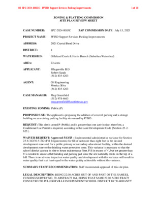
ZONING & PLATTING COMMISSION SITE PLAN REVIEW SHEET CASE NUMBER: SPC-2024-0083C ZAP COMMISSION DATE: July 15, 2025 PROJECT NAME: PFISD Support Services Parking Improvements ADDRESS: 2021 Crystal Bend Drive DISTRICT: 1 WATERSHED: Gilleland Creek & Harris Branch (Suburban Watershed) AREA: 22 acres APPLICANT: AGENT: Pflugerville ISD Robert Sands (512) 835-4203 Gil Engineering Monica Silva (512) 835-4203 CASE MANAGER: Meg Greenfield (512) 978-4663 meg.greenfield@austintexas.gov EXISTING ZONING: Public (P) PROPOSED USE: The applicant is proposing the addition of covered parking and a storage building on an existing parking facility site owned by PfISD. REQUEST: This site is zoned P (Public) and is greater than one acre in size; therefore, a Conditional Use Permit is required, according to the Land Development Code {Section 25-2- 625}. WAIVER REQUEST: Approved 5/13/25 - Environmental administrative variance for Section 25-8-342/30-5-342 (Fill Requirements) for fill of not more than eight feet in the desired development zone and, for a public primary or secondary educational facility, within the desired development zone or the drinking water protection zone. This variance is necessary so that the school district can use its site to house maintenance fleet. Fill in excess of 4', but not greater than 8' is needed to create a flat building and parking pad since the site naturally exists on the top of a hill. There is no adverse impact on water quality and development with this variance will result in water quality that is at least equal to the water quality achievable without the variance. SUMMARY STAFF RECOMMENDATION: Staff recommends approval of this site plan. LEGAL DESCRIPTION: BEING 22.00 ACRES OUT OF AND PART OF THE SAMUEL CUSHING SURVEY NO. 70 ABSTRACT 164, BEING THAT SAME 22.00 ACRE TRACT CONVEYED TO PFLUGERVILLE INDEPENDENT SCHOOL DISTRICT BY WARRANTY 08 SPC-2024-0083C - PFISD Support Services Parking Improvements1 of 18 DEED RECORDED IN VOLUME 9988, PAGE 688 OF THE REAL PROPERTY RECORDS OF TRAVIS COUNTY, TEXAS AND 14.924 ACRES SHOWN AS LOT 1, BLOCK "A" OF THE WHEELER ADDITION IN THE PLAT DOCUMENT NO. 200300028. ALLOWED IMPERVIOUS COVER: 80% EXISTING IMPERVIOUS COVER: 46% PROPOSED IMPERVIOUS COVER: 57% SUMMARY COMMENTS ON SITE PLAN: All comments are cleared except for Transportation Public Works – awaiting Travis County approval of sidewalks and driveway. ZONING OVERLAYS: Wildland Urban Interface: Proximity Class - Within 1.5 miles of a Wildland Area SURROUNDING CONDITIONS: North: Single Family (ETJ) East: Business Park (LI) West: Single Family (ETJ) South: Pflugerville ISD Transportation Services (P) NEIGHBORHOOD ORGANIZATION: Friends of Austin Neighborhoods Homeless Neighborhood Association North Gate Neighborhood Association Pflugerville Independent School District 08 SPC-2024-0083C - PFISD Support Services Parking Improvements2 of 18 Property Profile Legend Property Jurisdiction FULL PURPOSE EXTRATERRITORIAL JURISDICTION 2 MILE ETJ AGRICULTURAL AGREEMENT Jurisdictions Fill Jurisdiction FULL PURPOSE EXTRATERRITORIAL JURISDICTION 2 MILE ETJ AGRICULTURAL AGREEMENT Zoning 1 Zoning CS GR LI MF P RR SF Zoning Text Notes 0 500 1000 ft 7/9/2025 This product is for informational purposes and may not have been prepared for or be suitable for legal, engineering, or surveying purposes. It does not represent an on-the-ground survey. This product has been produced by the City of Austin for the sole purpose of geographic reference. No warranty is made by the City of Austin regarding specific accuracy or completeness. 08 SPC-2024-0083C - PFISD Support Services Parking Improvements3 of 18 January 11, 2024 ENGINEER’S SUMMARY LETTER For: Pflugerville Independent School District RE: Pflugerville ISD Transportation Services Pflugerville, TX 78660 To Whom It May Concern: Legal Description BEING 22.00 ACRES OUT OF THE SAMUEL CUSHING SURVEY NO. 70, ABSTRACT 164 AND 14.924 ACRES SHOWN AS LOT 1, BLOCK “A” OF THE WHEELER ADDTION PLAT DOCUMENT NO. 200300028. Introduction The project site consists of a total 36.924 acre tract. The only new development as a part of this site development permit will occur on the north portion of the tract that is already developed as the PfISD Support Services building. A new storage building and additional parking is to be placed on an area that is currently pervious. Re-paving and re-striping as well as some parking lot remodeling will occur in the already developed areas, but are included in the limits of construction. The area of the limits of construction is approximately 3.52 acres. The 36.924 acre tract currently resides within the limits of the City of Austin and is zoned P. The site is NOT within the limits of a 100 year flood plain. There are no natural streams on this site. There are NO areas irrigated with wastewater. The 36.924 acre tract site area does not have slopes greater than 15% with the exception of drainage structures. This site is currently in the Walnut Creek Watershed which is classified as Suburban. The site is zoned P (Public). The 36.924 acre tract is bounded to the north by Crystal Bend Dr. and the west by Lazyridge Dr. The areas past these drives are located in the City of Austin ETJ. The areas to the east and south of the 36.94 acre tract are zoned LI (Light Industrial) with one adjoining tract to the south zoned CS-CO. The planned improvements, which are the subject of this Report, consist of the construction of a new 7,425 sq. ft. storage building on a portion of the site that has no existing impervious cover on it. 9,396 sq. ft. of existing asphalt and 2,058 sq. ft. of existing concrete will be removed. 87,174 sq. ft. of new asphalt parking and 08 SPC-2024-0083C - PFISD Support Services Parking Improvements4 of 18 drives will be constructed as well as 18,263 sq. ft. of concrete will be constructed which includes sidewalks, but most of this square footage will be constructed in the form of heavy duty concrete paving. The tract currently is detained by an existing detention pond along with an existing water quality pond as shown in the plans. The flows from this project for existing impervious cover will flow into existing drainage patterns. An additional new detention and water quality pond will detain flows from the new impervious cover. The detention and filtration ponds offset the increase in runoff from this project. The project is to begin as soon as possible (upon project approval) and is to be completed within 12 months (after site plan approval). There is no proposed phasing of the project. This project will take construction access from the existing drive off Lazyridge Drive as shown on the ESC plan. Soils The Austin sheet of the Geologic Atlas of Texas shows that the majority of the site is Austin Chalk Formation. These sandy lean clay soils extend down 1-5 feet and are moderately draining. Zoning Currently this site is in the City of Austin Full Purpose Jurisdiction. Currently the zoning is P for the site. Flood Hazard The 36.924 acre site is currently classified as zone X un-shaded an area outside the 0.2% annual chance flood hazard based on map number 4845Cc0270J effective date August 18, 2014. A portion of the FEMA map has been included in this report along with a Google image with the flood hazard boundaries overlaid onto the image. The site is in the Walnut Creek Watershed of the Colorado River Basin. Discussion of the Existing and Proposed Drainage Patterns Sheet CG103 of the attached Site Development Drawings show the existing drainage conditions for the site. The site proposed to be developed in this site plan currently drains to the south west. Captured areas in the already developed portion of the site are piped to the existing water quality pond. The patterns will remain unchanged. 08 SPC-2024-0083C - PFISD Support Services Parking Improvements5 of 18 Discussion of Proposed Method of Treating Both Quantity and Quality of Stormwater Run-Off The quantity and quality of stormwater run-off will be handled by the existing and detention ponds and existing water quality ponds. The water quality BMPs are designed to City of Austin standards. The existing impervious cover will continue to be captured by the existing water quality ponds and existing detention ponds. The portion of the site that was uncaptured with new impervious cover will now be handled by the new water quality and new detention pond. There is NO floodplain modification proposed by this Site Plan. There is no floodplain on the site therefore there is no proposed modification by this site plan. Discussion of Proposed Variances There are NO variances proposed by this project. Transfer of Development Information There is no transfer of Development elements from other projects. Critical Environmental Features within the Project and Know Features within 150 feet of the Project The surrounding area is partially developed. A cursory review by the undersigned of the entire site area did NOT reveal any critical environmental features within the site boundary. An ERI is submitted with this project as the project is in the Tree Preservation Plan There are no existing trees to be moved as a part of this project. There are no trees located in the limits of construction. Known Underground Storage Tanks There are NO known underground storage tanks located within the project area and/or the entire 36.924 acre site area. Proposed Cut and Fill greater than 4’ 08 SPC-2024-0083C - PFISD Support Services Parking Improvements6 of 18 There are cuts and fills greater than 8’ proposed by the planned improvements only in the building pad. The cuts are limited to the north side of the tract. The slope of the tract along with the footprint of the building causes the building footprint to span over 12’ in elevation. There is also an area where the bus drive will need a retaining wall that is approximately 8’. There are no site cuts or fills greater than 8’ SUBURBAN WATERSHED PROJECT REPORT PREPARED BY: Victor M. Gil, P.E., R.P.L.S. TBPE Firm Registration Number F-1186 08 SPC-2024-0083C - PFISD Support Services Parking Improvements7 of 18 08 SPC-2024-0083C - PFISD Support Services Parking Improvements8 of 18 This Master Comment Report includes all staff comments received to date about your most recent site plan submittal. The comments may include requirements, recommendations, or information. The requirements in this report must be addressed by an updated site plan submittal. Case Number: SPC-2024-0083C Revision #: 00 Case Manager: Meg Greenfield Phone #: Update: U5 Email: meg.greenfield@austintexas.gov Project Name: PFISD Support Services Parking Improvements Location: 2021 CRYSTAL BEND DR Submittal Date: June 23, 2025 Report Due Date: July 8, 2025 Final Report Date: July 9, 2025 1 DAY HAS BEEN ADDED TO THE UPDATE DEADLINE Update Deadline (Expiration Date): June 3, 2025 Final Update Deadline [LDC § 25-5-113]: • Failure to submit a final update by the deadline will result in the automatic denial of the application, unless: (1) The site plan application has been approved; or (2) A request for an extension has been granted. [LDC § 25-1-82(F)] • If the deadline falls on a weekend or City of Austin holiday, the next City of Austin workday will be the deadline. • The applicant or their agent is responsible for updating this site plan application and clearing all comments. Update Submittals: • A formal update submittal is required. Updates can be submitted through the Site Plan Update and Formal Web Form. Updates submitted after 3:00 p.m. may be processed on the following business day. • A written response to every comment is required in addition to the updated plan set. • More comments may be generated as a result of information or design changes provided in your update. Site Plan Approval: • The site plan will be approved when all requirements from each review discipline have been addressed. 08 SPC-2024-0083C - PFISD Support Services Parking Improvements9 of 18 REVIEWERS: Planner 1 : Shakayla Stevenson TPW-TDS : Abigail Wake-Mayo Fire For Site Plan : Richard Schaffner Industrial Waste : Christopher Bost Site Plan : Meg Greenfield AW Utility Development Services : Bradley Barron AW Pipeline Engineering : Daniel Lofton TPW-TDS Review – Abigail Wake-Mayo (512) 978-0756 - abigail.wake-mayo@austintexas.gov TPW 1. All parking must be provided in accordance with design and construction standards of the TCM. Reference TCM Table 9-1, Table 9-2, and Table 9-3. Show dimensions for: stall width, depth of stall 90 degrees to aisle, width of stall parallel to aisle, aisle width, module width, and angle of parking stalls. U1: Comment pending. Provide the correct stall width and depth dimensions. U2: Comment cleared. TPW 2. Proper signs and markings are required to reinforce one-way traffic circulation and flow. TCM, 9.3.2.E. Note the direction of flow and show the location of "One-Way" and "Do Not Enter" signs for one-way drives and aisles. U1: Comment cleared. TPW 3. Identify the location of bicycle parking on the site plan, note the number of short-term and long- term spaces to be provided, show the direct unobstructed path connecting bicycle parking to the development entrance, and show a detail of the bicycle rack(s) (City of Austin standard detail #710S-1 or S-2, and 710S-6C, approved 2012). The minimum requirement is 5% of the motor vehicle spaces prior to reductions, or 5 spaces whichever is greater, LDC 25-6-477, Appendix A. TCM, 9.8.1. U1: Comment pending. Please disperse the bike racks to be located within 50 ft. of the principal building entrances. (TCM, 9.8.2.A). Include the number of long-term vs short-term bicycle spaces provided in the parking table. U2: Comment cleared. TPW 4. Long-term bicycle parking is required for an office use. 70%—90% of required bicycle parking for Business and professional offices must be long-term (weatherproof and secured). TCM, 9.8.0, 9.8.3. U1: Comment pending. The fence around the property does not meet the security requirements for long-term bike parking. It must be either a bicycle cage or a storage room. (TCM, 9.8.3.F). U2: Comment pending, include a callout on the drawing “Long-term covered bike parking enclosed in 6’ high fence”. U3: Comment cleared. TPW 5. A pedestrian parking path shall be provided for 50% of on and off-street parking and loading facilities. TCM 9.3.3.2.A. U1: Comment pending. Pedestrian parking paths shall be provided that do not require a person using the route to travel in a traffic lane or behind a parked vehicle (except the vehicle the person operates or in which the person is a passenger). These can be accomplished through the use of optional landscape medians as well as providing perimeter sidewalks around the edge of a 08 SPC-2024-0083C - PFISD Support Services Parking Improvements10 of 18 surface parking lot. U2: Comment cleared. TPW 6. Show the minimum number of loading spaces required based on the use from Appendix A. Show the required loading spaces on the site plan. Each off-street loading zone must consist of a rectangular area not less than 12 feet wide and 25 feet long, with a vertical clearance of not less than 15 feet. Identify the loading space and show dimensions on the site plan. LDC Section 25-6- 531, 532. TCM, 9.4.1.A. U1: Comment pending. Include the number of loading spaces provided in the parking table. Verify and show the ratio per Appendix A. U2: Comment cleared. TPW 7. Sidewalks are required for site plans. Please provide written confirmation from Travis County (email will suffice) indicating whether they approve this site without sidewalks along Lazyridge Dr and Crystal Bend Dr, or include the sidewalks in accordance with the TCM requirements. LDC 25-6-352; TCM, Table 2-2, 2-3; Figure 2-15, 2-16. U1: Comment pending. Show the required sidewalks OR provide the correspondence from Travis County. U2/U3/U4: Comment pending correspondence from Travis County. U5: Sidewalks are required along Lazyridge DR and Crystal Bend DR in accordance with the TCM comprising a 6’ wide clear zone (sidewalk), which should be offset 2’ from the existing property boundary. These sidewalks are required unless Travis County explicitly prohibits sidewalks within their right-of-way for this site. TPW 8. Driveways on Travis County-maintained roadways must be approved by Travis County. Written sign-off (email will suffice) is required prior to the release of the site plan. U1/U2/U3/U4: Comment pending. A sign-off from Travis County is required, regardless of whether the driveways are existing. This ensures that Travis County does not require any modifications to the existing driveways. U5: Comment cleared. TPW 9. Show all driveway dimensions, including width (measured at the property line), curb return radii, spacing between driveways, and throat storage length. U1: Comment pending. Please ensure that a minimum of 60 feet of throat storage length is provided between the property line and the first interruption point (e.g., the first intersecting aisle, internal driveway, or parking stall) at each driveway. Kindly verify the throat length dimensions. The red line indicates where the interruption point appears to be: 08 SPC-2024-0083C - PFISD Support Services Parking Improvements11 of 18 U2: Existing non-conforming driveways may be required to conform with City standards, including driveway closing and curb construction where appropriate (LDC 25-6-295, 25-6-321, 25-6-322). Please show the gate on the site plan and measure the distance from the property boundary to the gate (throat storage length). Entry driveways equipped with controlled access gates must provide a minimum of 40 ft. of storage space measured from the gate to the property line. (TCM, 9.3.4.2.E ) If a waiver is being sought please send this directly to this reviewer, the memo should outline the code requirement, why this cannot be met and any supporting information (e.g. frequency of use, size of design vehicle). U3: Comment cleared. TPW 10. Indicate the total number of parking spaces provided for the entire development. Based on this number and the number of driveways, demonstrate compliance with TCM, Table 9-5 (minimum throat storage length). Throat storage length is measured from the property line to an interruption point (the first intersecting aisle, internal driveway, or parking stall). U1: Comment pending. See TPW 9. U2: Driveway is gated, comment withdrawn (refer TPW 9). Fire For Site Plan Review – Richard Schaffner (512) 974-0159 - richard.schaffner@austintexas.gov FR1 – Current Status: Informal Update, project is approved informally, review status is Informal Update to keep fire review in the distribution list for any future updates to verify resolution to another discipline’s comments did not negatively impact any fire requirements. Industrial Waste Review – Christopher Bost (512) 972-1220 - christopher.bost@austintexas.gov IW 18. – Current Status: Pending final signoff. • Update 5: The status of this project is changed to “Informal Update” in AMANDA. This change in status does not imply final approval. Please contact your case manager for instructions on how to obtain final approval signatures and stamps. • Update 4: The status of this project is changed to “Informal Update” in AMANDA. This change in status does not imply final approval. Please contact your case manager for instructions on how to obtain final approval signatures and stamps. IW 19. – Current Status: Pending final signoff. • Update 5: The site plan as shown meets Industrial Waste requirements. Henceforth, any changes made with respect to: water service and meters, backflow preventers, auxiliary water (e.g. reclaim, rain water, well water, etc.), wastewater lines / service connections, or the location of wastewater sampling / inspection ports (2-way cleanouts, large diameter cleanouts, and wastewater manholes) must be resubmitted to Industrial Waste for review. 08 SPC-2024-0083C - PFISD Support Services Parking Improvements12 of 18 • Update 4: The site plan as shown meets Industrial Waste requirements. Henceforth, any changes made with respect to: water service and meters, backflow preventers, auxiliary water (e.g. reclaim, rain water, well water, etc.), wastewater lines / service connections, or the location of wastewater sampling / inspection ports (2-way cleanouts, large diameter cleanouts, and wastewater manholes) must be resubmitted to Industrial Waste for review. Site Plan Review – Meg Greenfield meg.greenfield@austintexas.gov SP1. – SP8 cleared. SP9. This project is not covered by the PfISD ILA because the support services are not covered under the ILA defibition of ‘educational facilities’. This site is zoned P (Public) and is greater than one acre in size; therefore, a Conditional Use Permit is required, according to the Land Development Code {Section 25-2-625}. Please contact this reviewer to place this item on the Zoning and Platting Commission agenda when all design-related comment are cleared. U1-3: comment pending. Once all design-related comments are cleared I will schedule the project for commission. U4: please let me know which of the following dates works for your team: U5: project svheduled for ZAP on 7/15. Notice has been sent and I’ll submit my staff report on 7/9. It’s likely the item will be on the consent agenda but regardless please have someone from the applciant’s team available to attend. SP10. When all comments are cleared, collect signatures/authorizations from reviewers external to the City of Austin, if required. Then coordinate with the Case Manager to circulate the final plan set for City of Austin required signatures. Please allow up to 5 business days for signatures to be completed. NOTE: Any changes to the plan set following the final submittal will require the Case Manager to restart the process of collecting signatures. U1-5: comment pending. SP11. Add location map to coversheet. U2: comment cleared. SP12. This note doesn’t make a lot of sense since it is referencing this site plan—is it supposed to be referencing an older site plan? U2: notes are still there. SP-2023-0083C isn’t a case that exists..is this note trying to say water quality was constructed under SPC-2019-0413C? this site plan appears to have included a new water quality pond. please add to related cases. U3: comment not cleared, please delete the above note. Also this note is on the coversheet 3 times: U4: comment not cleared. U5: comment cleared. 08 SPC-2024-0083C - PFISD Support Services Parking Improvements13 of 18 SP13 what is the difference between building coverage and overall building coverage? U3: comment cleared. AW Utility Development Services – Bradley Barron (512) 972-0078 - bradley.barron@austintexas.gov AW1. – Current Status: Pending U5: The review comments will be satisfied once Pipeline Engineering has approved the water and wastewater utility plan. For plan review status, contact Dan Lofton with Pipeline Engineering at (512)972-0234 or Daniel.Lofton@austintexas.gov. Reference: Per Utility Criteria Manual Section 2, §15-9, §25-4, §25-5, §25-9, and the Uniform Plumbing Code AW Pipeline Engineering – Daniel Lofton (512) 972-0234 - daniel.lofton@austintexas.gov 7/2/25 6th review RED LINE COMMENTS CAN BE FOUND AND DOWNLOADED FROM THE “ ATTACH LINK BELOW”: https://studio.bluebeam.com/share/rvcqhosasqf9tm END OF MASTER COMMENT REPORT Comment Resolution Process: You can submit a Comment Resolution Request if: 1. You have identified two or more comments in your Master Comment Report that conflict with each other; and 2. You do not believe that the comments can be satisfied. 08 SPC-2024-0083C - PFISD Support Services Parking Improvements14 of 18 Comment Resolution Requests can only be submitted and resolved between review cycles. They cannot be submitted while the site plan is in review. Use the Comment Resolution Request Web Form to submit your request. Questions or Concerns? Contact Us: If you have any questions or concerns or if you require more information about this report, please do not hesitate to contact your Case Manager at the email address listed at the top of this report or by writing to the City of Austin, Development Services Department, P.O. Box 1088, Austin, Texas 78767. 08 SPC-2024-0083C - PFISD Support Services Parking Improvements15 of 18 DRAINAGE NOTES: The Water Quality for this site plan was constructed with the Pflugerville ISD Support Services project construction plans SP-01-0075D. The Water quality ponds shown in this site plan are private and are privately maintained by the Pflugerville Independent School District. If any violations exist on an existing pond, the pond may not be approved for use until the red tag is cleared. Prior to construction, EV inspections will confirm if the existing pond is in good standing. The ponds will be maintained according to the requirements of the Environmental Criteria Manual Section 1.6.3 prior to release of the Certificate of Occupancy for this site. TCEQ EDWARDS AQUIFER MAP THIS SITE IS NOT LOCATED ON THE EDWARDS AQUIFER RECHARGE OR TRANSITION ZONES ACCORDING TO TCEQ MAP AND IS NOT LOCATED OVER THE EDWARDS AQUIFER ACCORDING TO CITY OF AUSTIN MAPS. FEMA FLOOD MAP FIRE FLOW DEMAND @ 20 PSI (gpm) OCCUPANCY CLASSIFICATION CONSTRUCTION CLASSIFICATION BUILDING FIRE AREA (S.F.) AUTOMATIC FIRE SPRINKLER SYSTEM TYPE (IF APPLICABLE) REDUCED FIRE FLOW DEMAND 20 PSI FOR HAVING A SPRINKLER SYSTEM (GPM)(IF APPLICABLE) 1750 GPM S-2 II-B 7425 SF N/A N/A N/A AFD FIRE HYDRANT FLOW TEST DATE 10/11/2024 AFD FIRE HYDRANT FLOW TEST LOCATION CITY OF AUSTIN PIPELINE ORDINANCE APPLIES TO PROJECT HIGH-RISE INTERNATIONAL WILDLAND-URBAN INTERFACE CODE ALTERNATIVE METHOD OF COMPLIANCE AMOC (IF APPLICABLE) 13600 LAZYRIDGE DR NO NO N/A N/A Approval of these plans by the City of Austin indicates compliance with applicable City regulations only. Approval by other governmental entities may be required prior to the start of construction. The applicant is responsible for determining what additional approvals may be necessary. Compliance with the Commercial and Multi-Family Recycling Ordinance is mandatory for multi-family complexes and businesses and office buildings. EXISTING SIDEWALKS TO REMAIN HAVE BEEN VERIFIED TO COMPLY WITH THE APPLICABLE VERSION OF THE TEXAS ACCESSIBILITY STANDARDS, FEDERAL ADA REQUIREMENTS, AND CITY OF AUSTIN STANDARDS. THIS PROJECT IS LOCATED IN THE HARRIS BRANCH WATERSHED, WHICH IS CLASSIFIED AS A SUBURBAN WATERSHED. PFLUGERVILLE INDEPENDENT SCHOOL DISTRICT SUPPORT SERVICES PARKING IMPROVEMENTS AUSTIN FIRE DEPARTMENT FIRE DESIGN CODES 2021 INTERNATIONAL FIRE CODE (IFC) WITH CITY OF AUSTIN LOCAL AMENDMENTS TO THE IFC LEGAL DESCRIPTION: BEING 22.00 ACRES OUT OF AND PART OF THE SAMUEL CUSHING SURVEY NO. 70 ABSTRACT 164, BEING THAT SAME 22.00 ACRE TRACT CONVEYED TO PFLUGERVILLE INDEPENDENT SCHOOL DISTRICT BY WARRANTY DEED RECORDED IN VOLUME 9988, PAGE 688 OF THE REAL PROPERTY RECORDS OF TRAVIS COUNTY, TEXAS AND 14.924 ACRES SHOWN AS LOT 1, BLOCK "A" OF THE WHEELER ADDITION IN THE PLAT DOCUMENT NO. 200300028. 2021 CRYSTAL BEND DR., PFLUGERVILLE, TX 78660 SUBMITTAL DATE 02/07/2024 RELATED CASES: SP-01-0075D SPC-2019-0413C ZONING CASE: C14-2024-0130 Sheet Number 1 2 3 4 5 6 7 8 9 10 11 12 13 14 15 16 17 18 19 20 21 22 23 24 25 26 27 28 29 29B 30 31 32 XX 4 5 6 7 8 9 10 11 12 13 14 15 16 17 Sheet List Table Sheet Title TITLE SHEET GENERAL NOTES ENVIRONMENTAL NOTES DEMO PLAN OVERALL EROSION CONTROL PLAN EROSION CONTROL PLAN EROSION DETAILS 1 OF 2 EROSION DETAILS 2 OF 2 OVERALL SITE PLAN WEST PARKING - BUILDING SITE PLANS EAST PARKING SITE PLAN SITE NOTES CIRCULATION PLAN OVERALL GRADING PLAN WEST PARKING & BUILDING GRADING PLAN EAST PARKING GRADING PLAN EXISTING DRAINAGE AREA MAP PROPOSED DRAINAGE AREA MAP OVERALL DRAINAGE PLAN STORM DRAIN PLAN STORM DETAILS EX POND PLAN OVERALL PAVING PLAN WEST PARKING PAVING PLAN EAST PARKING PAVING PLAN PAVING DETAILS 1 OF 2 PAVING DETAILS 2 OF 2 UTILITY PLAN UTILITY DETAILS UTILITY DETAILS 2 FIRE PROTECTION PLAN OVERALL LANDSCAPE PLAN PROPOSED LANDSCAPE PLAN SITE ELECTRICAL PLAN FOUNDATION PLAN FOUNDATION DETAILS FLOOR PLAN ELEVATIONS BUILDING SECTIONS 1 BUILDING SECTIONS 2 BUILDING SECTIONS 3 STRUCTURAL PLAN STRUCTURAL DETAILS ELECTRICAL PLAN ELECTRICAL DETAILS PLUMBING PLAN HVAC PLAN HVAC DETAILS Ordinance Requirements 1. All improvements shall be made in accordance with the released site plan. Any additional improvements will require a site plan amendment and approval from the Development Services Department. 2. (a)Approval of this Site Plan does not include Building and Fire Code approval nor building permit approval (b)All existing structures shown to be removed will require a demolition permit from the City of Austin Development Services Department. 3. All signs must comply with the requirements of the City of Austin Land Development Code. 4. The owner is responsible for all costs of relocation of, or damage to, utilities. 5. Additional electric easements may be required at a later date. 6. Water and wastewater service will be provided by the City of Austin — or identify the service provider if other than the City of Austin. 7. For construction within the right-of-way, a R.O.W. excavation permit is required. Compatibility 1. Highly reflective materials will not be used. Materials may not exceed 20% reflectivity. This requirement shall not apply to solar panels or to copper or painted metal roofs. 2. The noise level of mechanical equipment will not exceed 70 d.b.a. at the property line adjacent to residential uses. 3. All exterior lighting shall be hooded or shielded from the view of adjacent residential uses, or property zoned residential. 4. Exterior lighting above the second floor is prohibited when adjacent to residential property. 5. All dumpsters and any permanently placed refuse receptacles will be located at a minimum of twenty (20) feet from a property used or zoned as SF-5 or more restrictive. Fire Department 1. The Austin Fire Department requires asphalt or concrete pavement prior to construction as an "all-weather driving surface." 2. Hydrants must be installed with the center of the four-inch opening at least 18 inches above finished grade. The four-inch opening must face the driveway or street with three- to six-foot setbacks from the curbline(s). No obstruction is allowed within three feet of any hydrant and the four-inch opening must be totally unobstructed from the street. 3. TIMING OF INSTALLATION: When fire protection facilities are installed by the developer, such facilities shall include all surface access roads which shall be installed and made serviceable prior to and during the time of construction. Where alternative methods of protection, as approved by the Fire Chief, are provided, the above may be modified or waived. 4. All pervious/decorative paving shall be engineered and installed for 84,000 lb. live-vehicle loads. Any pervious/decorative paving within 100 feet of any building must be approved by the Fire Department. 5. Commercial dumpsters and containers with an individual capacity of 1.5 cubic yards or greater shall not be stored or placed within ten feet of openings, combustible walls, or combustible eave lines. 6. Fire lanes designated on site plan shall be registered with City of Austin Fire Marshal's office and inspected for final approval. 7. Vertical clearance required for fire apparatus is 14 feet for full width of access drive. P FLU G E R VILLE R D. PEC A N ST. D. UEL R N A M IM PROJECT LOCATION D. N R O R E M A C G R E G G M A N O R D. R U A S E S D N E A S T D E S S A U R D. 5 7 2 P O O L PAR M E. Y A G E E R L N . R L N. 5 3 - H I LOCATION MAP MAPSCO: P33 P34 WATERSHED: Harris Branch ZONING: P NOT TO SCALE OWNER: Pflugerville ISD PHONE: (512) 594-0017 ADDRESS: 1401 W. Pecan Street, Pflugerville, TX 78660 SPC-2024-0083C February 7, 2024 Site Development Permit Number Submittal Date APPROVED BY: Industrial Waste Date Austin Water Date THIS SITE IS NOT LOCATED WITHIN ANY DESIGNATED FLOOD HAZARD AREA AS SHOWN ON THE FEMA FIRM NO. 4845Cc0270J CITY OF AUSTIN, TRAVIS COUNTY, TEXAS EFFECTIVE DATE AUGUST 18, 2014. GENERAL CONSTRUCTION NOTES 1. ALL RESPONSIBILITY FOR THE ADEQUACY OF THESE PLANS REMAINS WITH THE ENGINEER WHO PREPARED THEM. IN REVIEWING THESE PLANS, THE CITY OF AUSTIN MUST RELY ON THE ADEQUACY OF THE WORK OF THE DESIGN ENGINEER. 2. Contractor shall call Texas 811 (811 or 1-800-344-8377) for utility locations prior to any work in City easements or street R.O.W. 3. Contractor shall notify the City of Austin – Site & Subdivision Division to submit required documentation, pay Construction Inspection Fees, and to schedule the required Site and Subdivision Pre-Construction Meeting. This meeting must be held prior to any construction activities within the R.O.W. or public easements. Please visit http://austintexas.gov/page/commercial-site-and-subdivision-inspections for a list of submittal requirements, information concerning fees, and contact information. 4. For slopes or trenches greater than five feet in depth, a note must be added stating: "All construction operations shall be accomplished in accordance with applicable regulations of the U.S. Occupational Safety and Health Administration." (OSHA standards may be purchased from the Government Printing Office; information and related reference materials may be purchased from OSHA, 611 East 6th Street, Austin Texas.) 5. All site work must also comply with Environmental requirements. 6. Upon completion of the proposed site improvements and prior to the following, the engineer shall certify in writing that the proposed drainage, filtration and detention facilities were constructed in conformance with the approved plans: release of the certificate of occupancy by the development services department (inside the city limits); or installation of an electric or water meter (in the five-mile ETJ) 7. Upon completion of the proposed site improvements and prior to the release of the certificate of occupancy or final inspection release by the city, the design engineer shall certify in writing that the proposed drainage and detention facilities were constructed in conformance with the approved plans. IF AT ANY TIME DURING CONSTRUCTION OF THIS PROJECT AN UNDERGROUND STORAGE TANK (UST) IF FOUND, CONSTRUCTION IN THAT AREA MUST STOP UNTIL A CITY OF AUSTIN UST CONSTRUCTION PERMIT IS APPLIED FOR AND APPLIED FOR AND APPROVED. ANY UST REMOVAL WORK MUST BE CONDUCTED BY A UST CONTRACTOR THAT IS REGISTERED WITH THE TEXAS COMMISSION ON ENVIRONMENTAL QUALITY (TCEQ). CONTACT ELIZABETH SIMMONS AT elizabeth.simmons@austintexas.gov IF YOU HAVE ANY QUESTIONS. NOTES: RELEASE OF THIS APPLICATION DOES NOT CONSTITUTE A VERIFICATION OF ALL DATA, INFORMATION AND CALCULATIONS SUPPLIED BY THE APPLICANT. THE ENGINEER OF RECORD IS SOLELY RESPONSIBLE FOR THE COMPLETENESS, ACCURACY AND ADEQUACY OF HIS/HER SUBMITTAL, WHETHER OR NOT THE APPLICATION IS REVIEWED FOR CODE COMPLIANCE BY CITY ENGINEERS. TEMPORARY BENCH MARKS Point # Elevation Northing Easting Description 1 2 692.90 10121434.72 3147784.05 1/2" REBAR SET W/RED CAP 724.92 10121603.49 3149161.82 BURY MAG NAIL ON SIDEWALK REVISION BLOCK No. Description Revise (R) Add (A) Void (V) Sheet No.'s Total # Sheets in Plan Set Net Change Imp. Cover (sq. ft.) City of Austin Approval / Date Date Imaged Austin Fire Department Date REVISIONS: .. Development Services Department Date ENGINEER: GIL ENGINEERING 504 E. BRAKER LN. Austin, TX 78753 Phone: (512) 835-4203 Fax: (512) 835-4407 ARCHITECT: JOSE M. GIL 504 E. BRAKER LN. Austin, TX 78753 Phone: (512) 835-4203 Fax: (512) 835-4407 PERMIT NUMBER: SPC-2024-0083C 1 31 SHEET:___ OF ___ SITE PLAN APPROVAL FILE NUMBER SPC-2024-0083C APPLICATION DATE February 7, 2024 APPROVED BY COMMISSION ON __________ UNDER SECTION 112 OF CHAPTER 25-5 OF THE CITY OF AUSTIN CODE. EXPIRATION DATE(25-5-15, LDC) ______ CASE MANAGER MEG GREENFIELD ZONING: COUNTY ZONING PROJECT EXPIRATION DATE (ORD.#970905-A) ____ DWPZ____ DDZ____ _______________________________________________________________ Director, Planning and Development RELEASED FOR GENERAL COMPLIANCE ______ ZONING P . REV. 1 __________________ CORRECTION 1 _______________________ REV. 2 __________________ CORRECTION 2 _______________________ REV. 3 __________________ CORRECTION 3 _______________________ Final plan must be recorded by the Project Expiration Date, if applicable. Subsequent site Plans which do not comply with the Code current at the time of filing, and all required Building Permits and/or a notice of construction (if a building permit is not required), must also be approved prior to the Project Expiration Date. SHEET NUMBER 1 S R E N G S E D I - S R O Y E V R U S - S R E N N A L P - I S R E E N G N E G N T L U S N O C I 3 5 7 8 7 S A X E T N T S U A I , E N A L R E K A R B . E 4 0 5 7 0 4 4 - 5 3 8 ) 2 1 5 ( X A F 3 0 2 4 - 5 3 8 ) 2 1 5 ( E N O H P I T E E H S E L : E T L T T T T E E H S . I 0 0 6 2 2 0 0 1 m i r i F g n y e v r u S d e r e t s g e R s a x e T i 6 8 1 1 - F m i r i F g n i r e e n g n E d e r e t s g e R s a x e T i - 3 2 0 2 5 2 - : 8 E T A D : N W A R D I I G N K R A P E C V R E S T R O P P U S . S T N E M E V O R P M I D S . : . I E L L I V R E G U E L L F T P T T C E J O R P I 08 SPC-2024-0083C - PFISD Support Services Parking Improvements16 of 18 LINE TYPE LEGEND <>EX 6'<> PROPERTY LINE ETJ PROPOSED MAINTENANCE EQUIPMENT BUILDING INFORMATION I E V R D E G D R Y Z A L I D O O H R O B H G I E N - S E I R A V . . W O R . R O T C E L L O C I H T D W T N E M E V A P ' 0 4 AUSTIN ETJ RESIDENTIAL I E L C R C L L I H P O T D O O H R O B H G I E N - S E I R A V . . W O R . R O T C E L L O C I H T D W T N E M E V A P ' 0 4 I R C L L I H P O T 9 6 1 0 - 2 7 D O O H R O B H G I E N - S E I R A V I E V R D L L I M Y H . . W O R . AUSTIN ETJ RESIDENTIAL EXISTING FIRE HYDRANT EX GAS EXISTING FIRE HYDRANT R O T C E L L O C I H T D W T N E M E V A P ' 0 4 R D L L I M Y H 7 9 8 6 9 <> EX ST <> EX ST E S T A G 72-0169 <> 230609 80008 80041 9045 A 7 2 8 0 - 0 7 7 9 6 2 7 O H E O H E O H E O H E F EX WWMH S A G X E F S F Y R C R . O . W . T V 4 L B R I E A A V A 0 ' P T T E 5 0 7 7 T F E N D D R I V S - N E I G H B O R H O O D E M E N T W I D T H T O R C O L C E L / / EXISTING PORTABLE UNIT B F OHE T 70-0054 S A G T F C = 3 9 > < 23"E 18" FL RCP 37.80, R = 2 8 2.7 21' 72° C O 4 N L = = L B C LOC LOC <> EX ST 12" FL RCP 70-0054 9046 79897 EX WWMH Irod Found 11087 713.31 8" PVC 9046 79897 230594 78.62' Existing Water Meter 90072 720.68 4 7 4 8 2 3 0 5 9 5 2001-0770 . < > ' R26.50' ' <> E <> R 2 6.5 0' <> 8 1 7 7 . 7 ' T F T F <> 5 . 3 8 9046 230600 8" PVC F LOC FIR E L A N E C O L EX ST FIRE LANE LOC LOC EXISTING ADMINISTRATION BUILDING C O L EXISTING CUT AND CAPPED SAND-OIL INTERCEPTOR E N A L 10 E R 13 I F SIGN "C" EX WW MANHOLE L O C EX FH LOC 2 3 0 5 9 9 2 0 1 8 - 0 8 8 2 6 " P V C 2001-0770 6" DI C 8 7 3 . 8 0 d F Ir o d n u o 15' WATER LINE EASEMENT TO THE CITY OF AUSTIN DOCUMENT NO. 2001058849 EXISTING GATE LOC FIRE L A N E EX GAS 2 0 0 1 - 0 7 7 0 C O L 6 " D EX ST I C O L C O L C O L CONTRACTOR TO FIELD VERIFY SIZE, CONTRACTOR TO FIELD VERIFY SIZE, DEPTH AND LOCATION OF EXISTING DEPTH AND LOCATION OF EXISTING UTILITIES PRIOR TO ANY NEW WORK UTILITIES PRIOR TO ANY NEW WORK LOC s t e W a t e r M H s t e W a t e r M H C O L 2 3 0 6 1 5 2 0 0 1-0 7 7 0 g W a g W a 1 1 1 1 0 0 . 8 0 . 8 x i s ti n x i s ti n 2 4 2 7 2 1 7 4 1 E 3 1 E CRYSTAL BEND DR EX WWMH NEIG(cid:43)BOR(cid:43)OOD COLLECTOR R.O.(cid:58). VARIES 2001-0770 Existing Water Meter S62° 32' 23"E 12314 678.67' 723.82 EX FH 218060 450232 230610 <> 9045 < > F <> EX WATER METER 2021 CRYSTAL BEND 2 1 8 0 6 1 R 4 6.8 1' 9 4 6 0 - 0 0 0 2 <> 15' WATER LINE EASEMENT TO THE CITY OF AUSTIN DOCUMENT NO. 2001058849 C O L < > 15' WATER LINE EASEMENT DOC. NO. 1999037830 C O L 1 1 3 2 1 7 68.68' EX ST 4 5 . 0 4 ' EXISTING ADMINISTRATIVE BUILDING 2021 CRYSTAL BEND < > C O L 2 . 1 2' EXISTING GATE EX WATER METER 2101 CRYSTAL BEND FIRELANE AUSTIN ETJ RESIDENTIAL TBM 2 // EX GM // O H E O H E s t e W a t e r M H CRYSTAL BEND DRIVE g W a R.O.W. VARIES - NEIGHBORHOOD COLLECTOR 40' PAVEMENT WIDTH <> <> <> EX ST 2 E 5 6 . 4 x i s ti n <> R 2 E " 7 0 ' 8 ' 3 0 . 4 O H E T 5 8 S ° 3 7 <> > < P C L R " F 8 1 O H E E T D R L E U N A M M I OHE E H O E H O O H E W W O H E O H E O H E O HE O HE H E O O H E O HE <>EX 6'<> H E O H E O C V P 6 T 5 4 4 0 8 9 0 7 4 2 5 8 4 0 8 8 0 4 3 0 2 E H O E H O E H O E H O FIRE LANE E N A L E R I F EXISTING AUTOMOTIVE BUILDING Existing Waste Water MH 12145 725.28 Existing Waste Water MH 12144 724.92 2 1 8 0 8 4 FIRE LANE EXISTING SAND-OIL INTERCEPTOR E N A L E R I F PROPOSED FIRE LANE EX > < > < EXISTING FIRE HYDRANT Existing Water Meter 90070 723.82 E S U O H E R A W EXISTING AUTOMOTIVE BUILDING 2101 CRYSTAL BEND I L G N N O Z I > < > < > < > < PROPOSED WATER LINE LANE FIRE > < ' C O E E N N L I I L L R R E E T T A A W W C C V V P P " " 8 8 . . X X E E 0 7 0 8 1 2 E E N N I I L L R R E E T T A A W W C C C V V P P O " " 5 5 2 2 X X E E . . L 218073 2 0 0 0 - 0 6 4 9 8 " P V C C O L CAUTION: EXISTING CAUTION: EXISTING UNDERGROUND UTILITIES UNDERGROUND UTILITIES < > C O L 3 0 4 4 2 < > < > L O 8 2 6 0 - 9 9 D S C V P X E 2 1 D S X E C V P 2 1 D S X E E H O E H O S S 8 0 4 3 0 D S X E 5 0 7 4 2 3 0 8 0 8 O O H H E E E H O E H O 8 P V C I L A T N E D S E R I J T E N T S U A I EXISTING FIRE HYDRANT EXISTING FIRE HYDRANT 2 3 0 5 9 7 8 3 9 7 2 O 8 0 7 > < L 1 1 0 7 7 0 - 1 0 0 2 C V P " 8 2 3 0 6 0 7 C 8 2 3 0 6 0 4 O L 3 9 7 2 > < C 8 2 3 9 6 3 6 E H O 4 5 0 0 - 0 7 4 5 0 0 - 0 7 R D E G D R Y Z A L I D O O (cid:43) R O B (cid:43) G E N I I L A T N E D S E R I J T E N T S U A I I E V R D E G D R Y Z A L I D O O H R O B H G I E N - S E I R A V . . W O R . 8 4 . 9 2 ' 0 7 7 0 - 1 0 0 2 7 3 9 7 2 R O T C E L L O C I H T D W T N E M E V A P ' 0 4 C V P " 8 1 > < > < > < 0 7 7 0 - 1 0 0 2 2 9 0 8 1 2 3 9 0 8 1 2 2 3 2 5 2 2 4 1 3 5 3 6 9 0 8 1 2 > < 1 1 241352 2 4 6 0 7 7 0 - 1 0 0 2 < > < > < > < > E " 1 4 ' 3 5 ° 7 2 N < > ' 6 2 . 7 3 6 < > 4 5 0 0 - 0 7 7 1 7 3 1 . ' LONG MEADOW DRIVE L A J R.O.W. VARIES T NEIGHBORHOOD I T E COLLECTOR N 40' PAVEMENT WIDTH N E D T S S U E A R I I R 2 5.0 0' 48.53' R 2 5.0 0' > < > < ' 9 0 0 8 . 0 7 5 0 - 0 0 0 2 6 6 1 8 1 2 1 3 2 5 2 5 6 1 8 1 2 R D E G D R Y Z A L I 4 5 0 0 - 0 7 I L A T N E D S E R I J T E N T S U A I 2 0 0 1 - 0 7 7 0 6 " D I E N A L E R I F C O LOADING SPACE L 15'X25' C O L LOADING SPACE 15'X25' C O L 1 C O L 9 BIKE RACKS 10 PROVIDED C O L 1 O > < L 2001-0770 6" DI LOC <> ' > < . 6 3 1 7 6 EXISTING WQ POND 1SP EXISTING WQ POND 1SP < > 2 3 0 6 2 6 C O L > < 10 S E 3 9 I R 7 2 A V . R O T C E L E L (cid:58) O " O C 7 R 0 . . ' 1 5 ° 7 2 N > < R 2 9.5 2' < > <> <> C O L EX. 6" PVC EX. 6" PVC FIRE LANE <> <> > < LOC EX. 36" RCP SD LINE EX. 36" RCP SD LINE 51.34' LOC g S t o r m W a t e r M H C O L 9 BIKE RACKS 10 PROVIDED LOC LOC 1 1 0 4 7 13 0 SIGN "A" 8 4 . 6 x i s ti n 0 E FIRE LANE <> C O L 0 " R 0 " R X . 3 X . 3 E E 2 3 0 6 2 6 EX. FH EX. FH 2 3 0 6 1 7 < > 2000-0649 EX. 6" DI WATER LINE 2000-0649 EX. 6" DI WATER LINE > < R29.58' 15' WATER LINE EASEMENT TO THE CITY OF AUSTIN DOCUMENT NO. 2001058849 EXISTING DETENTION POND 2SP EXISTING DETENTION POND 2SP > < C O L <> <> <> < > > < 3 R 6 2 G E N E D D I S 9 L . P I D : U L F E P E O V 2 N T L E H O C T P 8 4 V I L S T R I C G . 8 , D . R . T . C . 2 . 0 A C 0 8 9 2 8 8 < > 2 0 0 0 - 0 6 4 9 6 PROPOSED FIRE LANE R W W A A T T E E R R M M A A N N 8 8 " " P P V V C C E S I I CAUTION: EXISTING UNDERGROUND UTILITIES < > 10 13 SIGN "B" < > L L W W " " 8 8 . . X X E E E E N N I I L L D D S S " " 4 4 2 2 PROPOSED FIRE LANE < > C O L C O L C O L C O L P D I N E E N N I I L L D D S S " " 7 7 2 2 X X E E E E D L I N D L I N P S P S C C V V A A N N N N N N O O O O P P P P A A A A R R R R K K K K N N N N G G G G I I I I PROPOSED FIRE LANE 2 1 . 9 0 9 x i s ti n C O L EX. 36" SD LINE EX. 36" SD LINE 7 3 6 3 0 E PROPOSED WASTEWATER LINE LOC g S t o r m W a t e r M H MECHANICAL M E N W O M E N 1 2 SEE PLUMBING PLAN FOR STUBOUT LOCATIONS 3 PROPOSED STORAGE BUILDING 4 5 CO CO 6 6 A C O L < > CLEAN OUTS REQUIRED AT EVERY CLEAN OUTS REQUIRED AT EVERY BEND AND WYE AND AT EVERY 75LF BEND AND WYE AND AT EVERY 75LF 15' WATER LINE EASEMENT TO THE CITY OF AUSTIN DOCUMENT NO. 1999037830 C O L < > PROPOSED WAREHOUSE BUILDING TRANS C O L EXISTING DETENTION POND 2TP EXISTING DETENTION POND 2TP TBM 2 EXISTING WQ POND 1TP EXISTING WQ POND 1TP LOC LOC LOC L L W W " " 8 8 . . X X E E LOC < > E E N N I I L L D D S S " " 4 4 2 2 < > 9 4 6 0 - 0 0 0 2 7 1 8 . 4 8 d F Ir o 2000-0649 d n u <> o <> <> <> <> <> <> <> <> <> 2000-0649 <> <> <> <> 9 2 1 8 1 2 24404 1020.36' N62° 09' 18"W < > < > <> <> <> <> <> > < > < A O B EXISTING, CAPPED WASTEWATER STUB OUT D I N EXISTING FIRE LANE <> E N A L 1 1 8.9 E N > A < L 5' E R I F > < EXISTING WQ POND 1TP EXISTING WQ POND 1TP P I D : D R O F P P E 6 1 6 U R E H T E E D D I S 0 2 5 O L 0 F U F E 3 N T G V < > < > <> S E E T S > < EXISTING FIRE LANE L O K A D I T I O N C D E L R H O > < C T 8 1 7 V I L S T R I C 0 O . P . R . T . C . N T 0 > < 6 6 8 O A L B E R 1 L E T E L O H < > W < > CAUTION: EXISTING CAUTION: EXISTING UNDERGROUND UTILITIES UNDERGROUND UTILITIES N A V EXISTING FIRE LANE E R I F EXISTING FIRE LANE E N A EXISTING DETENTION POND 2TP EXISTING DETENTION POND 2TP > F I R E < > L < L A N E 1 5 5.1 E FIR 8' <> W " 7 0 ' 1 5 ° 7 2 S u a s s e d D S X E 8 2 6 0 - 9 9 k - r 6 7 9 2 b u s e a p s s n 9 e s i n t i o c e g r . p . r . t . c . p s a 2 8 1 0 8 6 4 0 7 4 2 6 9 0 1 8 > < . 2 9 5 8 9 > < > < > < > < > < > < < > < > 2 1 0 E S U O H E R A W l o v I L G N N O Z I I R A P E R C / A I L G N N O Z I k r a p s s e 2 u b < > s i n t i o c EXISTING ADMINISTRATION BUILDING 0 1 0 o . p . r . t . c . 0 13600 IMMANUEL < > 4 4 s s s a d e e u 2 2 0 n E N A L W " 9 5 ' E R I F . 6 3 4 3 5 < > < > < > < > E N A L E R I F E N A L E R I F < > ' 2 5 ° 7 2 S 8 1 6 5 2 E S U O H E R A W I L G N N O Z I D A O R L E U N A M M I S E I R A V . W O R . 2 0 7 1 4 7 2 6 . 1 8 R O T C E L L C O V C P 8 Y T I C I H T D W T N E M E V A P ' 0 4 D R L E U N A M M I 3 0 7 4 2 3 7 1 8 1 2 8 2 6 0 - 9 9 C V P 8 C V P 8 D R L E U N A M M I 6 P V C C V P 8 (cid:61)ONING I-RR (cid:61)ONING P FIRELANE FIRE LANE FIRELANE FIRE LANE E N A L E R I F F I R E L A N E F I R E L A N E F I R < > E L A N E E N A L V A N E R I F F I R E L A N E F I R E L A N E N A V STOP F I R E L A 7 N E 0 1 1 6 FIRELANE <> <> FIRELANE FIRELANE FIRELANE FIRELANE STOP STOP STOP E N A L FIRE S62° 06' 53"E 198.01' FIRELANE FIRELANE 262.75' FIRELANE <> <> FIRELANE <> FIRELANE FIRELANE FIRELANE FIRELANE <> <> <> FIRELANE ' 9 4 2 3 . d n u o 7 9 0 . 0 9 d F Ir o 1 0 6 W 1 1 " 9 5 ' 2 5 ° 7 2 S INVESTMENT DR 3 d 4 1 . 3 n FIRELANE u 198.01' 9 d F Ir o N62° 06' 53"W o EXISTING FIRE LANE 1 1 4 6 2 5 4 5 . 8 7 d F Ir o <> d n u o <> <> <> <> <> <> EXISTING FIRE LANE 998.85' N62° 08' 09"W A T T ZONING CS-CO WAREHOUSE/GENERAL RETAIL ZONING LI WAREHOUSE MANUFACTURING C V P 8 1 2 P V C W " 7 0 ' 1 0 1 7 8 8 7 2 3 2 3 0 5 1 8 0 9 7 1 4 8 ° 2 7 1 1 2 6 S 8 3 1 0 2 4 2 . 0 0 7 d F 0 Ir o e 0 . 0 S , 8 P 7 4 0 1 1 ' . 0 0 0 S 7 T O P 0 2 g W a s t e W a t e r M H g S t o r m W a t e r M H g S t o r m W a t e r M H e 4 3 3 3 . 7 4 3 . 4 0 x i s ti n x i s ti n E d n T r e n u 2 a 1 . 6 x i s ti n 1 7 0 8 1 4 0 E o c 9 0 E 1 9 OVERALL SITE PLAN SCALE: 1"= 100' TEMPORARY BENCH MARKS 100 0 100 200 Point # Elevation Northing Easting Description SCALE: 1" = 100' N 1 2 692.90 10121434.72 3147784.05 1/2" REBAR SET W/RED CAP 724.92 10121603.49 3149161.82 BURY MAG NAIL ON SIDEWALK FH E INL AC E STMH WP C EC EMH FIRE LANE EX W OHU EX FO EX TELE EX WW EX GAS EX W EX COMM EX SD EX COMM LOC BICYCLE PARKING NOT TO SCALE 1 9 P ZONING DISTRICT EQUIPMENT STORAGE PROPOSED USE BUILDING COVERAGE 7,425 S.F. GROSS FLOOR AREA 7,425 S.F. NUMBER OF STORIES 1 ACTUAL HEIGHT 25' - 6" FINISH FLOOR ELEV. XX FOUNDATION SLAB ON GRADE CONSTRUCTION TYPE TYPE III-B STAFF / OCCUPANCY 0 EXISTING SUPPORT SERVICES BUILDING INFORMATION (2021 CRYSTAL BEND) ZONING DISTRICT EXISTING USE BUILDING COVERAGE GROSS FLOOR AREA 43,520 S.F. STORIES 1 P ADMINISTRATIVE SERVICES 43,520 S.F. ACTUAL HEIGHT FINISH FLOOR ELEV. 711.00 FOUNDATION 29' SLAB ON GRADE EXISTING MAINTENANCE BUILDING INFORMATION (2101 CRYSTAL BEND) ZONING DISTRICT EXISTING USE BUILDING COVERAGE GROSS FLOOR AREA STORIES P ADMINISTRATIVE SERVICES 10,970 S.F. 10,970 S.F. 1 ACTUAL HEIGHT FINISH FLOOR ELEV. 725.67 FOUNDATION 27' SLAB ON GRADE SITE INFORMATION TOTAL AREA OF SITE 22.00 AC. (958,320 S.F.) ZONING P BUILDING COVERAGE 61,915 S.F. 6.5% OF TOTAL SITE OVERALL GROSS FLOOR AREA 61,915 S.F. F.A.R. INFORMATION F.A.R. .05:1 5% OF SITE MAX. IMPERVIOUS COVER 80% TOTAL IMPERVIOUS COVER 548,856 S.F. 57% TOTAL OPEN SPACE 409,464 S.F. 43% I S R E N G S E D - S R O Y E V R U S - S R E N N A L P - S R E E N G N E G N T L U S N O C I I 3 5 7 8 7 S A X E T N T S U A I , E N A L R E K A R B . E 4 0 5 7 0 4 4 - 5 3 8 ) 2 1 5 ( X A F 3 0 2 4 - 5 3 8 ) 2 1 5 ( E N O H P 0 0 6 2 2 0 0 1 m r i F g n i y e v r u S d e r e t s i g e R s a x e T 6 8 1 1 - F m i r i F g n i r e e n g n E d e r e t s i g e R s a x e T 3 2 0 2 - 5 2 - 8 E T A D : : N W A R D I N A L P E T S L L A R E V O E . L T T T E E H S I : I I G N K R A P E C V R E S T R O P P U S . D S . . I E L L I V R E G U L F P E L T T T C E J O R P I : S T N E M E V O R P M I REVISIONS: .. SHEET NUMBER 9 CASE NUMBER: SPC-2024-0083C 08 SPC-2024-0083C - PFISD Support Services Parking Improvements17 of 18 I D O O H R O B H G I E N E V R D E G D R Y 7 9 6 2 7 Z A W L O R A I 7 2 8 0 - 0 7 - S E I R A V 5 0 7 7 . . . I E L C R C L L I H P O T 70-0054 O HE T 70 -0054 12" FL RCP D O O H R O B H G I E N - S E I R A V . . W O R . I R C L H T L D I I H W P T O N E T M E V A P R O T C 9 6 E 1 L 0 - L 2 7 O C < > 7 9 8 6 9 <> 9046 ' 0 4 79897 <> E X G A S D O O H R O B H G I E N - S E I R A V I E V R D L L I M Y H . 80008 W O R . . <> <> E S A T G <> <> 72-0169 230609 8" PVC 79897 9046 230594 2 3 0 5 9 5 2001-0770 F E <> T F T F < > <> <> <> <> < > F I R E L A N E <> E N A L E R I F FIR E L A N E CRYSTAL BEND DR NEIG(cid:43)BOR(cid:43)OOD COLLECTOR R.O.(cid:58). VARIES 9046 230600 8" PVC 2001-0770 <> <> <> <> <> FIRELANE FIRE LANE FIRE LANE FIRE LANE F I R E L A N E ADMINISTRATION BUILDING 2 0 0 1 - 0 7 7 0 6 " D I FIRELANE 2 3 0 6 1 5 2 0 0 1-0 7 7 0 FIR E LANE F I R E L A N E 2 0 0 1 - 0 7 7 0 6 " D I E N A L E R I F E N A L E R I F E N A L E R I F CONTRACTOR TO FIELD VERIFY SIZE, CONTRACTOR TO FIELD VERIFY SIZE, DEPTH AND LOCATION OF EXISTING DEPTH AND LOCATION OF EXISTING UTILITIES PRIOR TO ANY NEW WORK UTILITIES PRIOR TO ANY NEW WORK CAUTION: EXISTING CAUTION: EXISTING UNDERGROUND UTILITIES UNDERGROUND UTILITIES < > R O T C E L L O C I H T D W T N E M E V A P ' 0 4 T T T O H E O H E O H E O H E F F 2 3 0 5 9 7 > < 8 3 9 7 2 > < > < 2 3 0 6 0 7 0 7 7 0 - 1 0 0 2 C V P " 8 8 2 3 0 6 0 4 3 9 7 2 > < > < > < > < > < > < > < R D E G D R Y Z A L I D O O (cid:43) R O B (cid:43) G E N I R O T C E L L O C 8 2 3 9 6 3 6 S E 3 9 I R 7 2 A V . . . (cid:58) O R E " 7 0 ' 1 5 ° 7 2 N ' . 6 3 1 7 6 0 7 7 0 - 1 0 0 2 7 3 9 7 2 2 3 0 6 1 7 F E H O 4 5 0 0 - 0 7 4 5 0 0 - 0 7 S A G T F C = 3 9 5.3 7' < > <> 23"E L=437.80, R=2 8 2.7 8 CB=N72° 21' <> 18" FL RCP < > < > 2001-0770 6" DI 2 3 0 5 9 9 2 0 1 8 - 0 8 8 2 6 " P V C 2001-0770 6" DI <> <> 2 3 0 6 2 6 EXISTING WQ POND 1SP EXISTING WQ POND 1SP < > < > < > > < > < > < < > <> <> FIRE LANE > < EX. 6" PVC EX. 6" PVC FIRE LANE <> <> < > EX. 36" RCP SD LINE EX. 36" RCP SD LINE FIRE LANE FIRE LANE <> <> <> < > 2000-0649 EX. 6" DI WATER LINE 2000-0649 EX. 6" DI WATER LINE E E N N I I L L D D S S " " 7 7 2 2 X X E E E E D L I N D L I N P S P S C C 0 " R 0 " R X . 3 X . 3 E E 2 3 0 6 2 6 EX. FH EX. FH V V A A N N N N N N O O O O P P P P A A A A R R R R K K K K N N N N G G G G I I I I MECHANICAL M E N W O M E N 1 2 3 4 5 6 6 A < > < > > < > < > < > < > < > < > < > < R O T C E L L O C I H T D W T N E M E V A P ' 0 4 C V P " 8 1 0 7 7 0 - 1 0 0 2 EXISTING DETENTION POND 2SP EXISTING DETENTION POND 2SP > < > < <> <> <> <> <> EX. 36" SD LINE EX. 36" SD LINE E N A L E FI R EXISTING DETENTION POND 2TP EXISTING DETENTION POND 2TP EXISTING WQ POND 1TP EXISTING WQ POND 1TP I E V R D E G D R Y Z A L I D O O H R O B H G I E N - S E I R A V . . W O R . 450232 230610 S62° 32' 23"E F 9045 678.67' 218060 > < 2 1 8 0 6 1 9 4 6 0 - 0 0 0 2 <> < > < > < > < > E E N N I I L L R R E E T T A A W W C C V V P P " " 5 5 2 2 X X E E . . E E N N I I L L R R E E T T A A W W C C V V P P " " 8 8 . . X X E E 0 7 0 8 1 2 218073 2 0 0 0 - 0 6 4 9 8 " P V C 3 0 4 4 2 < > < > < > < > < > < > < > 2 0 0 0 - 0 6 4 9 8 8 " " P P V V C C W W A A T T E E R R M M A A N N I I CAUTION: EXISTING CAUTION: EXISTING UNDERGROUND UTILITIES UNDERGROUND UTILITIES < > L L W W " " 8 8 . . X X E E < > E E N N I I L L D D S S " " 4 4 2 2 < > < > < > < > < > L L W W " " 8 8 . . X X E E E E N N I I L L D D S S " " 4 4 2 2 < > < > < > 9 4 6 0 - 0 0 0 2 R O T C E L L O C I R H D T D L W L T I M N E M Y H E V A P ' 0 80041 4 9045 // O H E O H E CRYSTAL BEND DRIVE R.O.W. VARIES - NEIGHBORHOOD <> <> <> <> 40' PAVEMENT WIDTH <> F I R E L A N E FIRE LANE E N A L E R I F E N A L E R I F FIRELANE FIRELANE AUTOMOTIVE BUILDING FIRE LANE FIRE LANE FIRE LANE FIRE LANE E N A L E R I F E N A L E R I F 2 1 8 0 8 4 MINIMUM OF 3 INCHES OF ORGANIC MULCH TO BE USED FOR THE PLANTING OF NEW GREENERY. [ECM 2.4.5(A)] IF ESTABLISHING VEGETATION DURING ANY STAGE OF A DROUGHT, SECTION 6-4-30 MAY REQUIRE A VARIANCE. CONTACT AUSTIN WATER CONSERVATION STAFF AT WATERUSECOMPVAR@AUSTINTEXAS.GOV OR CALL (512) 974-2199. THE OWNER WILL CONTINUOUSLY MAINTAIN THE REQUIRED LANDSCAPING IN ACCORDANCE WITH LDC 25-2-984. FINISHED ELEVATION FOR PARKING-LOT ISLANDS, MEDIANS, PENINSILAS, AND SIMILAR LANDSCAPE AREAS MUST BE AT LEAST (6) INCHES BELOW THE FINISHED PARKING LOT ELEVATION TO ALLOW FOR PLACEMENT OF SIX (6) INCHES OF TOPSOIL. ALL LANDSCAPED AREAS ARE TO BE PROTECTED BY 6-INCH WHEEL CURBS, WHEELSTOPS OR OTHER APPROVED BARRIERS AS PER ECM2.4.7. LDC 25-2-1004(A), ECM 2.4.7 (A) PARKING LOT SCREENING: 140 L.F. 140 POINTS REQUIRED 27 POINTS - 3 LARGE TREES; 3.5" CALIPER 72 POINTS - 24 LARGE SHRUBS 42 POINTS - 22 SMALL SHRUBS 98,281 1,608,409 206,303 206,303 20 45 6 0 3 49 16 8 8 0 0 248 475 207,026 103,513 0 0 0 103,513 3,554 15,036 9,006 94,507 0 103,513 I I G N K R A P E C V R E S T R O P P U S . S T N E M E V O R P M I D S . . I E L L I V R E G U L F P E L T T T C E J O R P I : I S R E N G S E D - S R O Y E V R U S - S R E N N A L P - S R E E N G N E G N T L U S N O C I I 3 5 7 8 7 S A X E T N T S U A I , E N A L R E K A R B . E 4 0 5 7 0 4 4 - 5 3 8 ) 2 1 5 ( X A F 3 0 2 4 - 5 3 8 ) 2 1 5 ( E N O H P 0 0 6 2 2 0 0 1 m r i F g n i y e v r u S d e r e t s i g e R s a x e T 6 8 1 1 - F m i r i F g n i r e e n g n E d e r e t s i g e R s a x e T 3 2 0 2 - 5 2 - 8 E T A D : : N W A R D N A L P E P A C S D N A L L L A R E V O E . L T T T E E H S I : LANDSCAPING LEGEND STREET YARD BOUNDARY EXISTING TREES (cid:61)ONING I-RR 4" TOPSOIL AND BERMUDA GRASS HYDROMULCH PROVIDED IN HATCHED AREAS TEMPORARILY IRRIGATED UNTIL ESTABLISHED BUR OAK - Quercus macrocarpa Michx. 65 GALLON, 3.5" CALIPER 22 PROVIDED 6 9 0 8 1 2 > < 241352 <> 2000-0649 <> <> <> <> <> <> <> <> <> 2000-0649 <> <> <> <> <> <> 9 2 1 1 8 2 1020.36' 24404 N62° 09' 18"W 4 5 0 0 - 0 7 2 9 0 8 1 2 3 9 0 8 1 2 2 3 2 5 2 2 4 1 3 5 3 0 7 7 0 - 1 0 0 2 < > <> <> <> <> <> <> <> <> < > (cid:61)ONING P CENIZO/TEXAS SAGE (leucophyllum frutescens) - 1 GAL 24 PROVIDED TEXAS LANTANA (lantana horrida) - 1 GAL 22 PROVIDED > < 1 31 OVERALL LANDSCAPE PLAN SCALE: 1"= 60' 60 0 60 120 SCALE: 1" = 60' N REVISIONS: .. SHEET NUMBER 31 CASE NUMBER: SPC-2024-0083C 08 SPC-2024-0083C - PFISD Support Services Parking Improvements18 of 18