03 C14-2024-0170 - Duval PDA; District 6 - Staff Report Part 1 — original pdf
Backup
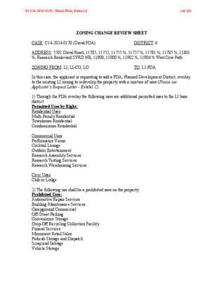
ZONING CHANGE REVIEW SHEET CASE: C14-2024-0170 (Duval PDA) DISTRICT: 6 ADDRESS: 5501 Duval Road; 11705, 11755, 11755 ½, 11757 ½, 11781 ½, 11785 ½, 11801 ½, Research Boulevard SVRD NB, 11900, 11900 ½, 11902 ½, 11904 ½ West Cow Path ZONING FROM: LI, LI-CO, LO TO: LI-PDA In this case, the applicant is requesting to add a PDA, Planned Development District, overlay to the existing LI zoning to redevelop the property with a mixture of uses (Please see Applicant’s Request Letter - Exhibit C). 1) Through the PDA overlay the following uses are additional permitted uses to the LI base district: Permitted Uses by Right: Residential Uses Multi-Family Residential Townhouse Residential Condominium Residential Commercial Uses Performance Venue Cocktail Lounge Outdoor Entertainment Research Assembly Services Research Testing Services Research Warehousing Services Civic Uses Club or Lodge 2) The following use shall be a prohibited uses on the property: Prohibited Uses: Automotive Repair Services Building Maintenance Services Campground Commercial Off-Street Parking Convenience Storage Drop-Off Recycling Collection Facility Funeral Services Monument Retail Sales Pedicab Storage and Dispatch Scrap and Salvage Vehicle Storage 03 C14-2024-0170 - Duval PDA; District 61 of 103 Recycling Center Resource Extraction Railroad Facilities 3) In addition, the applicant proposes the following modification to the LI base zoning district through the PDA: Site Development Regulations: Minimum Lot Size: 5,750 sq ft Minimum Lot Width: 50 ft Maximum Height: 60 ft Minimum Setbacks: A 50-ft minimum setback shall be required from property zoned SF-5 or more restrictive. Front Yard: 0 ft: Street Side Yard: 0 ft Interior Side Yard: 0 ft 0 ft Rear Yard: Maximum Floor Area Ratio (FAR): 2:1 Maximum Impervious Cover: Set forth by Watershed Maximum Building Coverage: Set forth by Watershed SITE AREA: 57.21 acres PROPERTY OWNER: Karlin Duval, LLC APPLICANT/AGENT: Armbrust & Brown PLLC (Richard T. Suttle, Jr.) CASE MANAGER: Sherri Sirwaitis (512-974-3057, sherri.sirwaitis@austintexas.gov) STAFF RECOMMEDATION: Staff recommends LI-PDA, Limited Industrial-Planned Development Area Combining District zoning, to change a condition of zoning. The PDA will be subject to the following additional conditions: 1) Cocktail Lounge use will be limited to 30,000 sq. ft. on the property. 2) Outdoor Entertainment use will be limited to 20,000 sq. ft. on the property. 3) Buffer Zone: A 75-foot wide setback shall be established and maintained between property developed with the Residential uses listed below: Multi-Family Residential Townhouse Residential Condominium Residential 03 C14-2024-0170 - Duval PDA; District 62 of 103 And the following Commercial and Industrial uses listed below: Research Assembly Services Research Testing Services Research Warehousing Services Construction Sales and Services Automotive Rentals Automotive Sales Custom Manufacturing General Warehousing and Distribution Light Manufacturing Limited Warehousing and Distribution 4) Prohibit the following additional uses on the property: Basic Industry 5) The development of the property will be subject to the updated recommendations in the US 183 and Duval Office Complex TIA Compliance Memorandum from the Transportation and Public Works Department (TPW) dated February 8, 2022 – Exhibit D. ZONING AND PLATTING COMMISSION ACTION / RECOMMENDATION: April 15, 2025: Approved staff’s request for a postponement to June 3, 2025 by consent (9-0, S. Boone and T. Major-absent); R. Puzycki-1st, A. Flores-2nd. June 3, 2025 CITY COUNCIL ACTION: ORDINANCE NUMBER: 03 C14-2024-0170 - Duval PDA; District 63 of 103 ISSUES: N/A CASE MANAGER COMMENTS: The property in question is the former 3M Company campus that is zoned LI, LI-CO and LO. It is currently a 57.21 acre vacant tract of land with access to Research Boulevard, Duval Road and West Cow Path. The parcel directly to the north is zoned LI and is undeveloped. Further to the north there is a tract zoned IP that contains an office development (Riata Corporate Park) that fronts Riata Trace Parkway. To the south, there is right-of-way zoned LO and a retail center (Angus Square) zoned GR. There are single-family residential lots zoned SF-2, SF-3, SF-1 and RR to the east and west. Near the northeast intersection of Duval Road and West Cow Path there are detention ponds and a primary school (Davis Elementary School) zoned SF-2 and a retirement home (Brookdale North Austin) zoned LO-CO. Along Research Boulevard to the west, there is a vacant office use, zoned GR with a pad site of CS zoning that contains a pawn shop services use (Cash America Pawn). In this rezoning request, the applicant is asking to add a PDA, Planned Development District, overlay to the existing LI zoning to redevelop the property with a mixture of uses including 1,200 multifamily residential units and 30,000 square feet of retail and restaurant uses (please see Applicant’s Summary Letter – Exhibit C). The staff recommends Limited Industrial-Planned Development Area District zoning as the property meets the intent of the LI-PDA combining district. The zoning would be compatible and consistent with the surrounding uses because there are office, commercial and industrial uses located to the north and south and residential and civic uses to the east and west. The staff recommendation includes proposed compatibility setbacks between the residential uses and more intensive commercial/industrial uses on the property. This has been done in other PDA cases throughout the city to provide a buffer between these types of uses. In addition, the staff recommends prohibiting Basic Industry as this use is incompatible with residential development: § 25-2-5 - INDUSTRIAL USES DESCRIBED. 1) BASIC INDUSTRY use is the use of a site for: (a) the basic processing and manufacturing of materials or products predominately from extracted or raw materials; (b) storage or manufacturing processes that involve flammable or explosive materials; or (c) storage or manufacturing processes that involve hazardous or commonly recognized offensive conditions, including poultry processing. The proposed LI-PDA zoning would allow this site to be redeveloped with a mixture of higher density residential, office, commercial and industrial uses. This location is appropriate for the proposed mixture of uses because the property in question is at the northeast intersection of a major arterial roadway, Research Boulevard/U.S. Highway 183, a collector roadway, Duval Road, and a local roadway, West Cow Path. In addition, the property is located 0.25 miles from Jollyville Road Activity Corridor and is 0.10 miles from a Capital Metro bus stop along Research Boulevard Service Road North Bound. There is a sidewalk 03 C14-2024-0170 - Duval PDA; District 64 of 103 C14-2024-0170 and bike lane present along Duval Road and a sidewalk along West Cow Path, with civic services such as a primary school and neighborhood park nearby. BASIS OF RECOMMENDATION: 1. The proposed zoning should be consistent with the purpose statement of the district sought. Limited Industrial Service district is intended as an area primarily for commercial services and limited manufacturing uses, generally on moderately sized sites. Planned Development Area combining district is intended for combination with selected commercial and industrial base districts, in order to modify base district provisions as necessary to allow for appropriate industrial and commercial uses or to reflect the terms of a Planned Development Area agreement following annexation of properties subject to such an agreement. 2. The proposed zoning should promote consistency and orderly planning. The LI-PDA zoning district would be compatible and consistent with the surrounding uses because there are commercial and industrial uses located to the north, south and west and residential uses to the east and west. The PDA request includes a 50-ft minimum setback from property zoned SF-5 or more restrictive and the staff’s recommendation adds a setback/buffer zone between the residential and more intensive commercial/industrial uses on the property. 3. Zoning changes should promote an orderly relationship among land uses. LI-PDA zoning would allow for this site to be developed with a mixture of residential, office, commercial and industrial uses. This location is appropriate for the proposed mixture of uses because the property in question is 0.25 miles from Jollyville Road Activity Corridor and in an area with civic amenities such as schools and parks. 4. The proposed zoning should allow for a reasonable use of the property. The LI-PDA zoning district would allow for a fair and reasonable use of the site. The proposed addition of the Planned Development Area Combining District will allow for higher density residential uses, which will provide desirable housing opportunities for the people that work within this development and in the surrounding commercial and industrial areas. There are public transportation options available nearby as the property is adjacent to bus stop along Research Boulevard Service Road North Bound and there is a bike lane present along Duval Road. 03 C14-2024-0170 - Duval PDA; District 65 of 103 EXISTING ZONING AND LAND USES: ZONING LAND USES LI, LI-CO and LO Site North LI, IP East SF-1, RR, SF-2, LO-CO South LO, GR West SF-2, SF-3, GR, CS Vacant – Former 3M Company Campus Undeveloped Area, Office (Riata Corporate Park) Single-Family Residences, Detention, Public Primary School (Davis Elementary School), Retirement Home (Brookdale North Austin) ROW, Restaurant (Short Stop) Retail Center (Angus Square) Single-Family Residences, Vacant Office Building, Pawn Shop (Cash America Pawn) NEIGHBORHOOD PLANNING AREA: N/A WATERSHED: Walnut Creek CAPITOL VIEW CORRIDOR: N/A SCENIC ROADWAY: NEIGHBORHOOD ORGANIZATIONS: Angus Valley Area Neighborhood Association, Austin Independent School District Bull Creek Foundation Friends of Angus Valley Friends of Austin Neighborhoods Homeless Neighborhood Association North Oaks Neighborhood Association Long Canyon Homeowners Association Mountain Neighborhood Association (MNA) Raintree Estates Save Our Springs Alliance Summit Oaks Neighborhood Association TNR BCP-Travis County Natural Resources SCHOOLS: Austin I.S.D, Round Rock I.S.D. AREA CASE HISTORIES: NUMBER C14-2020-0146 (11705 Research Blvd Zoning) REQUEST COMMISSION LI-CO to LI-CO 7/06/21: Motion to deny the rezoning request (5-2-1, Timothy Bray and Ellen Ray - No, Carrie Thompson-abstain); Betsy Greenberg-1st, David King- 2nd. Commissioners CITY COUNCIL 11/14/21: Approved LI-CO zoning, with conditions, on 1st reading by consent (11-0); P. Renteria-1st, P. Ellis-2nd. 03 C14-2024-0170 - Duval PDA; District 66 of 103 Cesar Acosta, Nadia Barrera- Ramirez and Hank Smith were absent. Motion failed. Forward to City Council without a recommendation. 9/05/17: Motion to approve staff’s recommendation of SF-3 zoning made by S. Lavani-1st, B. Evans-2nd. Substitute motion to approve SF-3 zoning, with a conditional overlay to prohibit Duplex Residential use and to provide on-site parking for accessory dwelling units made by A. Denkler, B. Evans-2nd. Vote: (5-6, D. King, A. Aguirre, J. Duncan, J. Kiolbassa, B. Greenberg, Y. Flores- No). The motion failed. Returned to the original motion to approve staff’s recommendation of SF-3 zoning (4-7, D. King, A. Denkler, A. Aguirre, J. Duncan, J. Kiolbassa, B. Greenberg, Y. Flores-No). The motion failed. Case sent forward to the City Council without a recommendation. 12/18/07: Approved staff recommendation of SF-3 zoning by consent (8-0); K. Jackson-1st, J. Shieh-2nd. 2/29/00: Approved staff recommendation of LO zoning, with prohibition on Medical Office uses and a 2,000 vehicle trip per day limit (7-0) 11/10/98: Approved staff rec. of LO- CO, with conditions for no vehicular access to Bell Avenue, access to Tweed Court is permitted only if TxDoT prohibits access to U.S. 183 and a 2,000 vehicle trip per day limit (7-0) 6/27/89: Approved LI-CO zoning with conditions: 1) 40 foot height limit, 2) prohibit Scrap and Salvage Services, Convenience Storage, Automotive Rentals, Automotive 10/12/17: Approved the staff’s recommendation for SF-3 zoning on 1st reading (10-1, L. Pool-No); J. Flanningan-1st, D. Garza-2nd. 11/09/17: Ordinance No. 20171109- 063 for SF-3 district zoning was approved on Council Member Alter’s motion, Council Member Houston’s second on a 10-1 vote. Council Member Pool voted nay. 1/17/08 : Approved SF-3 zoning by consent (7-0); all 3 readings 3/30/00: Approved LO-CO zoning, with conditions as recommended by Planning Commission on all 3 readings (6-0) 1/14/99: Approved PC rec. of LO- CO zoning, with conditions (7-0); 1st reading 3/25/99: Approved LO-CO zoning with conditions (6-0); 2nd/3rd readings 7/27/89: Approved LI zoning, with conditions, on 1st reading 1/18/90: Approved LI-CO zoning, with conditions, on 2nd/3rd readings SF-2 to SF-3 C14-2017-0085 (Charles Ford Rezoning: 12101 ½ Conrad Road) SF-2 to SF-3 SF-2 to LO LO, GR to LO-CO C14-2007-0228 11722 Bell Avenue) C14-00-2008 (Summit Oaks Office Park: Howlett Ct.) C14-98-0155 (Tweed Court: 12000 Block of Bell Avenue and Tweed Court) LO to LI C14-89-0009 (Wilson Tract: 11805-11841 Block of North 03 C14-2024-0170 - Duval PDA; District 67 of 103 U.S. Highway 183) Repair Services, Automotive Sales, Automotive Washing, Resource Extraction, Hotel-motel, Basic Industry and Vehicle Storage uses, 3) prohibit the following uses on the rear portion of the property for a depth of 150 feet: General Warehousing and Distribution, Equipment Sales, Equipment Repair Services and Kennels, and 4) the property is subject to TIA conditions. RELATED CASES: C14-85-244; C14-89-0009; C14-2020-0146 - Previous Zoning Cases CS-67-64, C8s-77-244; C8s-78-246; C8-2012-0017.0A – Subdivision Cases SP-2021-0108D; SP-2021-0109C; SP-97-0166CF – Site Plan Cases OTHER STAFF COMMENTS: Comprehensive Planning Project Name and Proposed Use: 5501 DUVAL ROAD. C14-2024-0170. Project: Duval PDA. 57.21 acres from LI, LI-CO.LO to LI-PDA. Existing: vacant. Proposed: 1,200 multifamily residential units and 30,000 square feet of retail and restaurant. Yes Y Imagine Austin Decision Guidelines Complete Community Measures * Imagine Austin Growth Concept Map: Located within or adjacent to an Imagine Austin Activity Center, Imagine Austin Activity Corridor, or Imagine Austin Job Center as identified the Growth Concept Map. Names of Activity Centers/Activity Corridors/Job Centers *: • 0.25 miles from Jollyville Road Activity Corridor Y Mobility and Public Transit *: Located within 0.25 miles of public transit stop and/or light rail station. • 0.10 miles from bus stop along Research Blvd Svrd NB Y Mobility and Bike/Ped Access *: Adjoins a public sidewalk, shared path, and/or bike lane. • Sidewalk and bike lane present along Duval Rd; sidewalk present along W Cow Path Y Connectivity, Good and Services, Employment *: Provides or is located within 0.50 miles to goods and services, and/or employment center. • Goods and Services available along Research Blvd and Duval Rd Connectivity and Food Access *: Provides or is located within 0.50 miles of a grocery store/farmers market. Y Connectivity and Education *: Located within 0.50 miles from a public school or university. • 0.3 miles to Davis Elementary School Y Connectivity and Healthy Living *: Provides or is located within 0.50 miles from a recreation area, park or walking trail. • 0.3 miles to Davis Elementary School park Y Connectivity and Health *: Provides or is located within 0.50 miles of health facility (ex: hospital, urgent care, doctor’s office, drugstore clinic, and/or specialized outpatient care.) 03 C14-2024-0170 - Duval PDA; District 68 of 103 • Multiple health facility options located at the intersection of Duval Rd and Jollyville Rd within 0.5 miles of the site Y Housing Choice *: Expands the number of units and housing choice that suits a variety of household sizes, incomes, and lifestyle needs of a diverse population (ex: apartments, triplex, granny flat, live/work units, cottage homes, and townhomes) in support of Imagine Austin and the Strategic Housing Blueprint. Housing Affordability *: Provides a minimum of 10% of units for workforce housing (80% MFI or less) and/or fee in lieu for affordable housing. Y Mixed use *: Provides a mix of residential and non-industrial uses. Culture and Creative Economy *: Provides or is located within 0.50 miles of a cultural resource (ex: library, theater, museum, cultural center). Culture and Historic Preservation: Preserves or enhances a historically and/or culturally significant site. Creative Economy: Expands Austin’s creative economy (ex: live music venue, art studio, film, digital, theater.) Workforce Development, the Economy and Education: Expands the economic base by creating permanent jobs, especially in industries that are currently not represented in a particular area or that promotes a new technology, and/or promotes educational opportunities and workforce development training. Industrial Land: Preserves or enhances industrial land. Not located over Edwards Aquifer Contributing Zone or Edwards Aquifer Recharge Zone 9 Number of “Yes’s” Drainage The developer is required to submit a pre- and post-development drainage analysis at the subdivision and site plan stage of the development process. The City’s Land Development Code and Drainage Criteria Manual require that the Applicant demonstrate through engineering analysis that the proposed development will have no identifiable adverse impact on surrounding properties. Environmental No comments. Fire No comments. Parks and Recreation Parkland dedication will be required at the time of subdivision or site plan application for new residential units, per City Code § 25-1-601, as amended. The proposed development meets the criteria for land dedication in City Code Title 25, Article 14. As such, a partial land dedication will be required, as well as any remaining fees in-lieu. 03 C14-2024-0170 - Duval PDA; District 69 of 103 The area is currently park deficient, defined as being outside walking distance to existing parks. The development as proposed will require parkland dedication for the new residential units that will serve the neighborhood being created through this PDA. Parks and Recreation Department (PARD) is open to working with the applicant to find suitable land that would work toward satisfying the requirement at time of permitting (whether subdivision or site plan). This land could be a neighborhood park for the 1000+ units proposed, improve neighborhood connectivity to and through the site for the existing neighbors, be a combination of these, or another idea to which PARD agrees. Should there be any remaining fees in-lieu, those fees shall be used toward park investments in the form of land acquisition and/or park amenities within the surrounding area, per the Parkland Dedication Operating Procedures § 14.3.11 and City Code § 25-1-609. Note that residential units that are certified affordable and income-restricted are exempt from the parkland dedication requirements per City Code § 25-1-601(D)(4). Please contact this reviewer: ann.desanctis@austintexas.gov in advance of site plan or subdivision applications. At the applicant’s request, PARD can provide an early determination letter of the requirements as stated in this review. Site Plan Zoning Cases 1. Site plans will be required for any new development other residential only project with up to 4 units. 2. Any new development is subject to Subchapter E. Design Standards and Mixed Use. Additional comments will be made when the site plan is submitted. Transportation ZONING REVIEW COMMENTS In lieu of a ZTA, please amend the existing TIA associated with SP-2021-0109C. LDC 25-6, TCM 10.5.0. (please see TIA Compliance Memo – Exhibit D). The Austin Strategic Mobility Plan (ASMP) calls for 116 feet of right-of-way for Duval. It is recommended that 58 feet of right-of-way from the existing centerline should be dedicated according to the ASMP with the first subdivision or site plan application. [LDC 25-6-51 and 25-6-55]. The Austin Strategic Mobility Plan (ASMP) calls for 58 feet of right-of-way for Duval. It is recommended that 29 feet of right-of-way from the existing centerline should be dedicated according to the ASMP with the first subdivision or site plan application. [LDC 25-6-51 and 25-6-55]. 03 C14-2024-0170 - Duval PDA; District 610 of 103 The adjacent street characteristics table is provided below: Name ASMP Classification ASMP Required ROW Existing ROW Existing Pavement Sidewalks Bicycle Route Capital Metro (within ¼ mile) Duval Rd Level 2/ Collector 116’ Varies 76’ Yes Yes Yes West Cow Path Level 1/ Local 58’ 78’ 45’ Research Blvd. Svrd. SB Level 4/ Major Arterial NA TXDOT 338’ (full 183 cross section) 40’ (service road) No Yes Portions of W Cow path have sidewalk No No Yes Water Utility No comments on zoning change. Please note additional information below: Due to a significant increase in total LUEs that will occur with the proposed development agreement, revisions to previously approved Service Extension Requests (SER) will be required to provide service to this lot. For more information pertaining to the Service Extension Request process and submittal requirements contact the Austin Water SER team at ser@austintexas.gov. Previously approved development plans constructing public infrastructure per previous SERs may be constructing infrastructure not adequately sized to serve the future development. It is recommended to contact the SER team ASAP to resolve prior to construction. FYI: The landowner intends to serve the site with City of Austin water and wastewater utilities. The landowner, at own expense, will be responsible for providing any water and wastewater utility improvements, offsite main extensions, utility relocations and or abandonments required by the land use. The water and wastewater utility plan must be reviewed and approved by Austin Water for compliance with City criteria and suitability for operation and maintenance. All new development within the proposed project will be subject to City Code Chapter 25-9 and any future amendments relating to reclaimed water connections, water benchmarking, and mandatory onsite water reuse. 03 C14-2024-0170 - Duval PDA; District 611 of 103 All water and wastewater construction must be inspected by the City of Austin. The landowner must pay the City inspection fee with the utility construction. The landowner must pay the tap and impact fee once the landowner makes an application for a City of Austin water and wastewater utility tap permit. INDEX OF EXHIBITS TO FOLLOW A: Zoning Map B. Aerial Map C. Applicant’s Request Letter D. TIA Compliance Memo E. Comments from Interested Parties 03 C14-2024-0170 - Duval PDA; District 612 of 103 ! ! ! ! ! ! ! ! ! ! ! ! ! ! ! ! ! ! ! ! ! ! ! ! ! ! ! ! ! ! ! ! ! ! ! ! ! ! ! ! ! ! ! ! ! ! ! ! ! ! ! ! ! ! ! ! ! ! ! ! ! ! ! ! ! ! ! ! ! ! ! ! ! ! ! ! ! ! ! ! ! ! ! ! ! ! ! ! ! ! ! ! ! ! ! ! ! ! ! ! ! ! ! ! ! ! ! ! ! ! ! ! ! ! ! ! ! ! ! ! ! ! ! ! ! ! ! ! ! ! ! ! ! ! ! ! ! ! ! ! ! ! ! ! ! ! ! ! ! ! ! ! ! ! ! ! ! ! ! ! ! ! ! ! ! ! ! ! ! ! ! ! ! ! ! ! ! ! ! ! ! ! ! ! ! ! ! ! ! ! ! ! ! ! ! ! ! ! ! ! ! ! ! ! ! ! ! ! ! ! ! ! ! ! ! ! ! ! ! ! ! ! ! ! ! ! ! ! ! ! ! ! ! ! ! ! ! ! ! ! ! ! ! ! ! ! ! ! ! ! ! ! ! ! ! ! ! ! ! ! ! ! ! ! ! ! ! ! ! ! ! ! ! ! ! ! ! ! ! ! ! ! ! ! ! ! ! ! ! ! ! ! ! ! ! ! ! ! ! ! ! ! ! ! ! ! ! ! ! ! ! ! ! ! ! ! ! ! ! ! ! ! ! ! ! ! ! ! ! ! ! ! ! ! ! ! ! ! ! ! ! ! ! ! ! ! ! ! ! ! ! ! ! ! ! ! ! ! ! ! ! ! ! ! ! ! ! ! ! ! ! ! ! ! ! ! ! ! ! ! ! ! ! ! ! ! ! ! ! ! ! ! ! ! ! ! ! ! ! ! ! ! ! ! ! ! ! ! ! ! ! ! ! ! ! ! ! ! ! ! ! ! ! ! ! ! ! ! ! ! ! ! ! ! ! ! ! ! ! ! ! ! ! SF-2 SF-2 ! ! ! ! ! ! !! ! ! ! ! ! ! ! ! ! ! ! ! ! ! ! ! ! ! ! ! ! ! ! ! ! ! ! ! ! ! ! ! ! ! ! ! ! ! ! ! ! ! 77-098(DE) SP-99-2220C 77 -0 9 5 LO 77-098(DE) 77-098(D E) S P-99-2220 C ( T W E E D C T ( ( B E L L A V E LO-CO SF-3 SF-2 ( D D R A R N O C ( ( ( ! ! ! ! 85-244 ! ! ! ! ! ! ! ! ! ! ! ( SF-2 ! ! ! ! ! ! ! SP97-0219C 75-128 85-244 SP9 7 -1 04 C EXHIBIT A ELECTRONICS MANUFACTURING PLANT IP OFFICE PARK SP97-0219C 85-244 OFFICE PARK SF-1 SP97-0219C SP97-104C 75-128 ( ( ( ( ( ( P O N Y C H A S E SF-1 ( ( ( ( ( SF-1 ( ( R A M B LIN G R A N G E ( ( ( ( ( ( ( H T A ( W P O T C S E W ( ( SF-1 ( B ULL R U N ( ( ( ! ! ! ! SP97-0166CF ! ! ! ! ! ! ! ! ! ! 85-244 LI SP97-0166CF ! ! ! ( ! ! ! ( ( D N S B U T C A C ( ( ! ! ! ! ! ! ! ! ( ! ! ( ( ! ! ! ( ! ! ! ! ! ! ! ! ! ! ( ( SF-1 ( B U LL R U N CIR ( ! ! ! ! ! ! ! ! ! ! ! ! SP97-0166CF ! ! ! ! ! C14-97-0036 97-0036 85-244 RR NORTHWEST ELEMENTARY 85-2449 SCHOOL 96-0013 C14-96-0013 FIR E P STATIO N S C H O OL SF-3 85-2449 SF-2 ( ( ( ( ( ( ( 85 -2 4 4 ( ( ( ( ( SF-1 ( ( ( ( ! ! ! ! ! ! ! ! ! ! ! C A R W A S H PAWN SHOP 2-19 8 C R C14-2017-0085 SF-2 SF-3 CS ! SF-3 ! ! RENTAL ! 77-67 ! ! REST. ! ! ! ! LO SF-3 ! -W 0 2 1 -1 0 8 ! ! ! 1 1 3 5- R-8 CS-CO T. S E R 78-217 ARABIAN TRL ! ! ! ! LO SF-3 RC79-44 RZ-85-006 GR ! ! ! ! ! 89-009 LI-CO C14-2020-0146 OFFICE ! ! ! ! ! ! ! ! ! ! SF-3 RC78-229 RC80-15 LO ( SF-2 4 - P L E X GR 79-044 ( E V L A L E B ( SF-2 ( S E C R E S T D R SF-2 ( SF-2 ( 8 77-4 SF-3 79-44 SP9 7 -0 11 4 C GR-CO SP-95-0292C 97-0118 97-0118 79-044 OFFICE.WAREHOUSE ! ! ! ! ! ! ! ! ! R E S E A R C H B L V D N B R E S E A R C H B L V D S B R E S E A R C H B L V D S V R D S B SP97-0319C BAR ! ! ! ! ! ! ! ! ! R E S E A R C H ! ! SP-95-0345C UNDEV B L V D ! S V R D N B UNDEV GR-CO GR-MU-CO 89-0022 GR 85-244 ! ! ! ! LO ! ! ! SP-93-0327C ! ! ! ! ! ! ! ! ! SP96-0326C RETIREMENT HOME C14-89-0071 SPC-93-0327C LO 93-0037 LO-CO D U V AL R D 79 -0 2 SP88-0283 GR CENTER RETAIL 79-40 VET. LR 8 7 88-0 GO-CO C14-2008-0064 RETIREMENT ZONING SUBJECT TRACT ! ! ! ! ! ! PENDING CASE ZONING BOUNDARY ZONING CASE#: C14-2024-0170 93-070 93-0070 LI-PDA UNDEV 78-137 LO LR-CO ± This product is for informational purposes and may not have been prepared for or be suitable for legal, engineering, or surveying purposes. It does not represent an on-the-ground survey and represents only the approximate relative location of property boundaries. 1 " = 400 ' This product has been produced by the Planning Department for the sole purpose of geographic reference. No warranty is made by the City of Austin regarding specific accuracy or completeness. Created: 11/19/2024 03 C14-2024-0170 - Duval PDA; District 613 of 103 EXHIBIT B 03 C14-2024-0170 - Duval PDA; District 614 of 103 EXHIBIT C 03 C14-2024-0170 - Duval PDA; District 615 of 103 03 C14-2024-0170 - Duval PDA; District 616 of 103 03 C14-2024-0170 - Duval PDA; District 617 of 103 03 C14-2024-0170 - Duval PDA; District 618 of 103 EXHIBIT D To: Ramin Komeili, P.E. From: Aditya Jatar (AJ), P.E. Austin Jones, P.E. Mustafa Wali City of Austin Permitting & Development Center 6310 Wilhelmina Delco Drive, Austin, TX 78752 BOE File: 100235 Date: April 7, 2025 Regarding: TIA Compliance – 183/Duval Site – SP-2021-0109C The following memorandum has been prepared in reference to the proposed development of US 183 and Duval site located at the northeast corner of US Highway 183 and Duval Road in Austin, Travis County, Texas. The TIA for the proposed site has already been completed and approved by City of Austin on February 8, 2022. The US 183 and Duval TIA approval memorandum has been included as Attachment 1. The location of the proposed development is shown in Figure 1. Figure 1 – Proposed US 183/Duval Site Location 03 C14-2024-0170 - Duval PDA; District 619 of 103 Since the TIA was approved and taking into consideration the current market conditions, the proposed site is to be rezoned for alternate land uses other than what were assumed as part of the approved TIA. Based on discussion with City of Austin, this TIA compliance memo includes comparison of the site trips between the original TIA land uses and recent updated proposed land uses, updated construction phasing of the identified improvements, and design and construction of the improvements identified in Table 6 shall be part of the site development application during the phase that they are associated with as deemed suitable for updated land uses. The updated TIA Determination worksheet corresponding to updated land uses has been included as Attachment 2. The previously approved US 183/Duval TIA was performed utilizing the ITE Trip Generation Manual, 10th Edition to establish the trip generation for the originally proposed land uses. Table 1 below summarizes the unadjusted trip generation documented within the US 183/Duval TIA. Table 2 below summarizes the unadjusted trip generation per phase documented within the US 183/Duval TIA. The total allowed TDM reductions per the approved TIA scope is 4.5 percent (4.5%), which is stated in Table 1 of the TIA Final Memo dated February 8, 2022, and is included as Attachment #1 with this compliance memo. Please note that the trips provided in all the Tables within this compliance memo are unadjusted trips which are typically tallied for TIA compliance based on prior TIA compliance memos submitted to the City of Austin. The Adjusted Trips are also provided in Table 1 of the TIA Final Memo. Build Ye a r ITE Code Pha se PR OPOS E D Table 1 –Approved TIA - Unadjusted Trip Generation La nd U se S ize 24-Hour Da ily Volume AM Pe a k Hour PM Pe a k Hour E nte r E xit Tota l E nte r E xit Tota l 710 820 General Office Retail 1,521,738 s.f. 14,880 1,253 10,000 sf 1,256 97 204 60 1,457 157 242 48 1,271 1,513 51 99 TOTAL PR OPOS E D 1,531,7 38 s.f. 16,136 1,350 264 1,614 290 1,322 1,612 Table 2 – Approved TIA – Unadjusted Trip Generation – Per Phase La nd U se S ize 24-Hour Da ily Volume AM Pe a k Hour E xit E nte r PM Pe a k Hour E xit Tota l Tota l E nte r Build Ye a r ITE Code Pha se PR OPOS E D 1 2 3 4 5 6 7 2022 2023 2024 2025 2026 2027 2028 710 710 710 710 710 710 General Office General Office General Office General Office General Office General Office 820 Retail 271,739 271,739 271,739 271,739 217,391 217,391 10,000 s.f. s.f. s.f. s.f. s.f. s.f. sf 2,798 2,798 2,798 2,798 2,254 2,254 1,256 241 241 241 241 198 198 6 39 39 39 39 32 32 4 282 282 282 282 231 231 9 47 47 47 47 38 38 47 247 247 247 247 200 200 51 294 294 294 294 238 238 99 TOTAL PR OPOS E D 1,531,7 38 s.f. 16,956 1,367 226 1,599 312 1,440 1,7 52 03 C14-2024-0170 - Duval PDA; District 620 of 103 The ITE Trip Generation Manual, 11th Edition is used to establish the trip generation for the current updated proposed land uses. Table 3 below summarizes the unadjusted trip generation for the current updated proposed land uses. Table 4 below summarizes the unadjusted trip generation per phase for the current updated proposed land uses. The breakdown of the trip generation summary for proposed land uses shown within Table 3 and Table 4 are included as Attachment #3 for reference. Pha se Build Ye a r ITE Code PR OPOS E D Table 3 – Unadjusted Trip Generation Updated Land Uses AM Pe a k Hour La nd U se S ize 24-Hour Da ily Volume E nte r E xit Tota l E nte r E xit Tota l PM Pe a k Hour 221 932 MF Mid Rise HT Restaurant 1,200 30,000 du sf 5,678 3,216 119 158 TOTAL PR OPOS E D 31,200 s.f. 8,894 27 7 397 129 526 516 287 803 286 166 452 182 106 288 468 272 7 40 Table 4 – Unadjusted Trip Generation Updated Land Uses – Per Phase Pha se Build Ye a r ITE Code La nd U se S ize PR OPOS E D 1 2 3 4 4 2026 2028 2030 2032 2032 221 221 221 221 MF Mid Rise MF Mid Rise MF Mid Rise MF Mid Rise 300 300 300 300 932 HT Restaurant 30,000 24-Hour Da ily Volume du du du du sf 1,419 1,419 1,419 1,419 3,216 TOTAL PR OPOS E D 31,200 s.f. 8,894 AM Pe a k Hour PM Pe a k Hour E nte r E xit Tota l E nte r E xit Tota l 30 30 30 30 158 27 7 99 99 99 99 129 526 129 129 129 129 287 803 71 71 71 71 166 452 45 45 45 45 106 288 117 117 117 117 272 7 40 When comparing the trips related to the originally approved TIA (Table 1) to what is currently proposed (Table 3), it can be seen and confirmed that the total site trips for the updated land uses are lower than the total site trips considered as part of the originally approved TIA and remain in compliance with the approved TIA. Table 5 below provides a summary of the remaining trips available for the US 183/Duval tract. Table 5 – Net Remaining Trips 24-Hour Daily Trip Generation Comparison Volume Enter Total Trips TIA 16,136 1,350 Total Trips for the Proposed Land Uses 8,894 277 AM Peak Hour Exit 264 526 PM Peak Hour Total Enter Exit Total 1,614 803 290 452 288 1,322 1,612 740 872 Net Remaining Trips 7,242 1,073 (262) 811 (162) 1,034 03 C14-2024-0170 - Duval PDA; District 621 of 103 The previously approved TIA considered US 183/Duval site to be developed primarily as an Office land use in multiple phases (Phase 1-Phase 6) as seen within Table 2. At this time, the US 183/Duval site is to be developed primarily as a Multi-Family land use in multiple phases (Phase 1- Phase 4) as seen within Table 4. The change in land uses results in opposite directional flow of trips to/from the site with switching of the AM and PM peak hour trips following the changes in major land use from Office to Multi-Family. The improvements identified as part of the original approved TIA memo (See Table 6) have been determined adequate to mitigate and support the total number of AM (1,614) and PM (264) site trips based on the major land use (Office) shown within Table 2. As the total number of AM (803) and PM (740) site trips based on the new proposed major land use (Multi-Family) shown within Table 4 are lower than trips shown with Table 2, the improvements identified shall continue to be adequate to mitigate and support the total AM (803) and PM (740) of the proposed new major land use (Multi-Family). Summary of Improvements Historically, a Fee-in-lieu contribution to the City of Austin would have been made for the improvements identified in Table 2a, before the site development permit was issued. With the passage of the Street Impact Fee (SIF) Ordinance, the Transportation Department will not collect this as a fee-in-lieu payment now but will collect it collect it in the form of SIF with each site plan as appropriate, as required by the SIF Ordinance. SIF is a process for funding the public roadway infrastructure to meet the needs of new development. SIF is the maximum allowable roadway impact fee that could be assessed by the COA. It is a technical calculation that quantifies the incremental cost of the impact of the proposed development on the street infrastructure. SIF is a charge assessed on new development to pay for the construction/expansion of roadway facilities that will benefit the proposed development area. Per the approved US 183/Duval TIA Approval Memo, several mitigation measures were identified. The mitigation measures identified for study area intersections were split into two components namely (i) design and construction improvements tied to phasing breakdown associated with land uses within the original approved TIA and (ii) SIF fees to be collected as discussed earlier. Table 6 below provides a summary of the recommended improvements and their breakdown into construction vs SIF as documented withing the US 183/Duval TIA Approval Memo. Design and construction of the improvements identified in Table 6 shall be part of the site development application during the phase that they are associated with. The City of Austin will confirm that these improvements have been constructed and completed in Phase 2 of the project during the Site Plan review of Phase 2 construction. If these improvements have not been constructed by the time the Phase 3 Site Plan application is submitted, the City of Austin reserves the right to deny any further applications for site development permit until the improvements listed have been completed. 03 C14-2024-0170 - Duval PDA; District 622 of 103 Table 6 – Recommended Improvements In tersecti on Recommen ded Improv emen ts US 183 NBFR & Duval Road Extend Westbound Right-turn Lane to 300 feet (250 feet storage/50 feet taper) Traffic Signal Timing Modifications Extend Eastbound Right-turn Lane to 800 feet (700 feet storage/100 feet taper) Mopac SBFR & Duval Road Install Southbound Left-turn Lane Install Southbound Right-turn Deceleration Lane Signal Infrastructure Modifications Traffic Signal Timing Modifications Install Westbound Right-turn Deceleration Lane Mopac NBFR & Duval Road Signal Infrastructure Modifications Traffic Signal Timing Modifications Duval Road & Angus Street Pedestrian Hybrid Beacon In tersecti on / Roadway Desi gn an d Con stru cti on Improv emen ts ( Requ i red) Requ i red Improv emen ts Impl emen ati on P h ase & Y ear ( A pprov ed TIA Memo 1) Requ i red Improv emen ts Impl emen ati on P h ase ( TIA Compl i an ce Memo 2) Duval Road (W Cow Path- US 183 NBFR) 400 feet of protected Bike Lane on Duval Road along property frontage per ASMP W Cow Path & Duval Road Signalize as Continuous Green T-intersection Phase 3 (2024) Phase 2 (2028) 1Reference approved TIA Final Memo (SP-2021-0109C) (Dated Feburary 8, 2022) within Appendix A.1 identifying Phase 3 (Year 2024) for implemenation timeline of the required improvements identified above. 2Based on the analysis presented within this TIA compliance memo, Phase 2 (Year 2028) is the comparable implemenation timeline of the required improvements identified above based on adjustement made to the proposed land uses. The US 183/Duval site shall be responsible for contributing towards the Street Impact Fee (SIF) program. The SIF will be collected at the time of buidling permit tied to each phase of site development. The eligible SIF Fees will be determined following guidelines available as part of City of Austin SIF Program. The US 183/Duval TIA Approval Memo considers Phase 3 (2024) for the implementation of the design and construction improvements identified under Table 6. The final approved plans for proposed signal at Duval Road & West Cow Path are included as Attachment 4. To determine the implementation year of the design and construction improvements identified under Table 6 as related to the updated land use, the percentage of site trips completed under Phase 3 (2024) is calculated as shown within Table 7 below. 03 C14-2024-0170 - Duval PDA; District 623 of 103 Table 7 – Percentage Trips for Phase 3 (2024) Original TIA 24-Hour Daily AM Peak Hour PM Peak Hour Trip Generation Comparison Volume Enter Phase 3 2024 Site Trips 8,394 724 Total Proposed Site Trips 16,956 1,367 Exit 118 226 Total Enter 846 1,599 141 312 Exit 742 Total 883 1,440 1,752 Average - Percentage of total proposed trips 50% 53% 52% 53% 45% 51% 50% Average 51% The percentage difference between the daily trips of the original TIA and proposed site trips based on updated land uses is 55%. Adjusting the percentage applicable to Phase 3 (2024) calculated within Table 7 results in 28%. Table 8 and Table 9 below show the calculations performed to determine the correct implementation year to design and of the design and construction improvements identified under Table 6 as related to trips from updated land uses. Table 8 – Percentage Factor Applicable to Phase 3 (2024) Original TIA Description ADT Percentage Percentage difference of Daily Trips between Original TIA and Updated Land Uses 16,956 8,894 Adjustment of percentage applicable to Phase 3 (2024) 51% * 55% 55% 28% Table 9 – Percentage Factor Applied to Trips for Proposed Site (Updated Land Uses) 24-Hour Daily AM Peak Hour PM Peak Hour Comparison Scenarios Volume Enter Total Proposed Site Trips Percentage of total proposed trips 8,894 2,490 28% 277 78 28% Exit 526 147 28% Total Enter 803 225 28% 452 127 28% Exit 288 81 28% Total 740 207 28% Table 10 below shows the summary of trips associated with updated land uses that meet the 28% percentage factor from Table 4. It can be seen that Applying 28% to Table 4 results in identifying Phase 2 (2028) to be comparable year for implementation of implementation of the design and construction improvements identified under Table 6 considering that Phase 2 (2028) exceeds the threshold calculated within Table 9. 03 C14-2024-0170 - Duval PDA; District 624 of 103 Table 10 – Implementation Year for Construction Improvements based on Updated Site Trips ITE 24-Hour Daily Phase Build Year Code Land Use Volume Enter Phase 2 2028 221 MF Mid Rise 2,839 60 AM Peak PM Peak Hour Exit 198 Total Enter 258 142 Hour Exit 90 Total 234 Please let us know if you have any questions or need any additional information. April 7, 2025 Sincerely, BOE CONSULTING SERVICES, LLC Texas Engineering Firm No. F-19220 Aditya Jatar (AJ), P. E Project Manager Phone: 737.301.2311 aj@bo-engineering.com 1: US 183/Duval TIA Approval Memo (2022-02-08) 2: COA Signed TDW (2024-11-05) 3: Trip Generation Calculations (Proposed Land Uses) 4: Duval/West Cow Path Approved Signal Plans (2024-03-06) 03 C14-2024-0170 - Duval PDA; District 625 of 103 01 US 183/DUVAL TIA APPROVAL MEMO 2022-02-08 03 C14-2024-0170 - Duval PDA; District 626 of 103 MEMORANDUM Date: To: CC: February 8, 2022 Bobak J Tehrany, P.E. (BOE) Curtis Beaty, P.E. Sangeeta Jain, AICP Reference: US 183 and Duval Office Complex – TIA Final Memo (SP-2021-0109C) Summary of the Transportation Impact Analysis (TIA): The Transportation Development Services Division (within the Austin Transportation Department, ATD) reviewed the December 2020 traffic impact analysis (TIA)report (received December 18, 2020) regarding the “US 183 and Duval Office Complex” development, prepared by BOE. The TIA was submitted with the Site Plan application, concurrent with a zoning application for a small subset of the site. The zoning case was contested by the neighborhood which caused there to be some uncertainty regarding its likelihood of being approved by Council. Due to this fact, transportation staff were not able to continue with the review of the Site Plan application until the zoning case was finalized, which caused the delay between receiving the TIA and this approval memo. The proposed development will consist of 1,521,738 SF of General Office and 10,000 SF of retail and is located at 11705 Research Blvd, as shown in Figure 1. The development is anticipated to complete construction in 2028. The following is a summary of the review findings and recommendations: 1. Historically, a Fee-in-lieu contribution to the City of Austin would have been made for the improvements identified in Table 2a, totaling $318,750, before the site development permit was issued. With the passage of the Street Impact Fee (SIF) Ordinance, the Transportation Department will not collect this as a fee-in-lieu payment now but will collect it at the time of building permit, as required by the SIF Ordinance. 2. Design and construction of the improvements identified in Table 2b shall be part of the site development application during the phase that they are associated with. ATD will confirm that these improvements have been constructed during the Site Plan review of Phase 3 construction. If these improvements have not been constructed by the time the Phase 4 application is submitted, ATD reserves the right to deny any further applications for site development permit until the improvements listed have been completed. 3. The applicant is required to achieve a vehicle trip reduction as described in Table 1. The applicant commits to implement the Transportation Demand Management measures to achieve the identified reduction. Page 1 of 7 03 C14-2024-0170 - Duval PDA; District 627 of 103 4. Development of this property should not vary from the approved uses or deviate from the approved intensities and estimated traffic generation assumptions within the finalized TIA document, including land uses, trip generation, trip distribution, traffic controls, driveway locations, and other identified conditions. Any change in the assumptions made to the approved TIA document that this memo references shall be reviewed by ATD and may require a new or updated TIA/addendum. 5. A final copy of the TIA should be delivered to ATD (digitally) to act as the copy of record. 6. City staff reserves the right to reassign any or all the above monies to one or more of the identified improvements as it deems appropriate. 7. The findings and recommendations of this TIA memorandum remain valid until five (5) years from the date of the traffic counts in the TIA or the date of this memo, whichever comes first, after which a revised TIA or addendum may be required. 8. Street Impact Fee Ordinances 20201220-061 and 20201210-062 have been adopted by City Council and are effective as of December 21, 2020. The City shall start collecting street impact fees with all building permits issued on or after June 21, 2022. For more information, please visit the Street Impact Fee website [www.austintexas.gov/streetimpactfee]. Page 2 of 7 03 C14-2024-0170 - Duval PDA; District 628 of 103 Figure 1 - Site Location Map LEGEND Project Site Site Location and Existing Conditions: The site is currently occupied by a 201,645 SF General Office complex. The proposed mixed- use development will utilize two (2) driveways for site access, as detailed below: • Driveway A (Private) - Full access along US 183 Northbound Frontage Rd • Driveway B (Private) - Full access along W Cow Path (northern driveway) • Driveway C (Private) – Full access along W Cow Path (southern driveway) Page 3 of 7 03 C14-2024-0170 - Duval PDA; District 629 of 103 Assumptions: 1. A 4.5% trip reduction was allowed due to the TDM measures proposed by the applicant. 2. Based on TxDOT AADT volume data, a one (1) percent annual growth rate was assumed to account for the increase in background traffic. 3. No background projects were identified in the vicinity of the site. 4. The project will be completed in seven (7) phases: • Phase 1 (2022) – 271,739 SF General Office • Phase 2 (2023) – 271,739 SF General Office • Phase 3 (2024) – 271,739 SF General Office • Phase 4 (2025) – 271,739 SF General Office • Phase 5 (2026) – 271,739 SF General Office • Phase 6 (2027) – 271,739 SF General Office • Phase 7 (2028) – 10,000 SF Retail Proposed Conditions: Trip Generation and Land Use Based on the Institute of Transportation Engineers (ITE) Trip Generation Manual (10th Edition), the development would generate approximately 16,136 unadjusted average daily trips (ADT) upon final build-out. Due to the number of vehicle trips and the anticipated traffic load on the roadway network, the applicant committed to a Transportation Demand Management (TDM) Plan to reduce their site vehicle trips by 4.5%. Table 1 shows the adjusted trip generation after applying TDM reductions and reductions for existing site trips. Transportation Demand Management (TDM) The applicant has committed to a 4.5% TDM reduction to meet vehicle trip reduction targets. In the TDM plan, the applicant identified several measures that could be implemented with the site to achieve the vehicle trip reduction. Table 1: Trip Generation Proposed Land Use Size / Unit 24-Hour Two Way Volume AM Peak Hour PM Peak Hour 710 General Office 820 Retail 1,521,738 SF 10,000 SF Total Unadjusted Trips TDM Reduction (4.5%) Existing Trips Total Adjusted Trips 14,880 1,256 16,136 (726) (2,095) 13,315 1,457 10 1,467 (66) (216) 1,185 1,513 99 1,612 (73) (222) 1,317 Page 4 of 7 03 C14-2024-0170 - Duval PDA; District 630 of 103 The applicant identified the following key TDM measures that may be used to achieve the 4.5% TDM reduction target: o Bicycle Parking o Showers & Lockers o Bicycle Repair Station o Telecommuting o TMA Membership No specific TDM measures are currently being proposed, however, individual site plans and phases of construction will provide proposals for specific TDM measures the developer will enact. Each phase will need to provide documentation and proof in any memos claiming compliance with this TIA memo to support the 4.5% TDM reduction being granted. If proper TDM measures can be proven, the 4.5% reduction will be upheld, otherwise, individual proposed phases of development included under this memo may be subject to the SIF without any TDM reduction. The determination will be made with each site plan submitted on this tract and may require additional mitigation or fee if an acceptable TDM plan cannot be provided. Page 5 of 7 03 C14-2024-0170 - Duval PDA; District 631 of 103 Summary of Recommended Improvements Table 2a: Recommended Improvements (Fee-in-Lieu) Intersection Improvement US 183 NBFR and Duval Rd Extend Westbound Right-Turn Lane to 300ft (250-foot storage/50-foot taper) Estimated Total Cost1 $187,500 Traffic Signal Timing Modifications $6,250 Extend Eastbound Right-Turn Lane to 800ft (700-foot storage/100-foot taper) $187,500 Install Southbound Left Turn Lane $312,500 Mopac SBFR & Duval Road Install Southbound Right-Turn Deceleration Lane $187,500 Signal Infrastructure Modifications $125,000 Traffic Signal Timing Modifications $6,250 Install Westbound Right-Turn Deceleration Lane $187,500 Signal Infrastructure Modifications $125,000 Traffic Signal Timing Modifications $6,250 Pedestrian Hybrid Beacon $150,000 Mopac NBFR & Duval Road Duval Road & Angus Street Table 2b: Required Improvements (Construction) Total: $1,481,2501 Duval Road (W Cow Path – US 183 NBFR) 400 ft of protected Bike Lane on Duval Rd along property frontage per ASMP W Cow Path & Duval Road Signalize as Continuous Green T-intersection 1 With the implementation of Street Impact Fees, ATD will collect this money as a SIF, not a separate payment as a Fee-In-Lieu. Page 6 of 7 03 C14-2024-0170 - Duval PDA; District 632 of 103 If you have any questions or require additional information, please contact me at (512) 974- 7136. Nathan Aubert, P.E. Austin Transportation Department Page 7 of 7 03 C14-2024-0170 - Duval PDA; District 633 of 103 02 SIGNED TIA DETERMINATION WORKSHEET 2024-11-05 03 C14-2024-0170 - Duval PDA; District 634 of 103 Traffic Impact Analysis (TIA) Determination Worksheet Applicant must complete this worksheet except where noted for TPW Staff. Please submit completed worksheet to the TIA Determination Worksheet portal (https://atd.knack.com/development- services#services/traffic-impact-analysis-determination/) for review and signature. Project Name: Location: Applicant: Telephone No: Application Type: *Indicates determination is optional Dev. Assessment (Zoning) Zoning Site Plan Dev. Assessment (Site Plan)* Concept Site Plan* By checking the box below, the applicant acknowledges that City Council has adopted a Street Impact Fee (SIF) program effective December 21, 2020, and that street impact fees will be assessed for any building permit pulled on or after June 21, 2022. For more information on the Street Impact Fee program, please visit www.austintexas.gov/department/street-impact-fee Applicant acknowledgment of Street Impact Fee program EXISTING: Tract Number Tract Acres Units** Zoning Land Use I.T.E. Code Trip Rate Trips Per Day FOR TPW STAFF USE ONLY Please note that existing trip generation in the above table is applicable only to this worksheet. Existing trip generation for use in transportation studies and SIF calculations shall be determined separately. PROPOSED: Tract Number Tract Acres Units** Zoning Land Use I.T.E. Code Trip Rate Trips Per Day FOR TPW STAFF USE ONLY **Applicable based on land use (e.g., dwelling units for residential, building square footage for commercial, etc.) ABUTTING ROADWAYS: Street Name Proposed Access (Y/N) Proposed Number of Driveways ASMP Street Level 1 of 2 Revised 03/19/2024 03 C14-2024-0170 - Duval PDA; District 635 of 103 FOR TPW STAFF USE ONLY A Transportation Demand Management (TDM) Plan is required. For more information on the contents required in a TDM Plan, please refer to Section 10 of the Transportation Criteria Manual (TCM) or contact a Lead Development Review Engineer. A traffic impact analysis is required. The consultant preparing the study must contact a Lead Development Review Engineer to discuss scoping requirements prior to beginning the study. Please see below for the type of study required; for more information on each study, please refer to Section 10 of the TCM. Full TIA Transportation Assessment (TA) Zoning Transportation Analysis (ZTA) TIA Compliance A traffic impact analysis is NOT required. Traffic generated by the proposal does not exceed the thresholds established in the City of Austin Land Development Code (LDC). Mitigation per LDC 25-6-101 may still apply. The traffic impact analysis has been waived for the following reason: A neighborhood traffic analysis (NTA) is required per LDC 25-6-114. The applicant may have to collect current traffic counts. Please contact a Transportation Planner for information. Reviewed By: Date: NOTE: A TIA determination must be made prior to submittal of any Zoning or Site Plan application; therefore, this completed and reviewed worksheet must accompany any subsequent application for the identical project. Changes to the proposed project may require a new TIA determination. This worksheet will remain valid for 90 calendar days from the approval date above, after which a new TIA Determination Worksheet will be required. 2 of 2 Revised 03/19/2024 03 C14-2024-0170 - Duval PDA; District 636 of 103 03 TRIP GENERATION CALCULATIONS PRPOSED LAND USED US 183 & DUVAL 03 C14-2024-0170 - Duval PDA; District 637 of 103 TRIP GENERATION SUMMARY EQ vs RATES (PROPOSED LAND USES) US 183 AND DUVAL ITE Trip Generation Manual 11th Edition - Rate/Equation Table ITE Code Land Use 221 MF Mid Rise 932 HT Restaurant 24-Hour Daily Volume Rate or Eq T = 4.77(X) - 46.46 107.2 AM Peak Hour PM Peak Hour % Ent % Ext Rate or Eq % Ent % Ext Rate or Eq 23% 55% 77% 45% T = 0.44(X) - 11.61 9.57 61% 61% 39% 39% T = 0.39(X) + 0.34 9.05 *This table was populated utilizing the criteria set by the ITE Trip Generation Handbook defining when a rate is to be utilized versus an equation. 1 of 1 2/27/2025 03 C14-2024-0170 - Duval PDA; District 638 of 103 SUMMARY OF TRIP GENERATION CALCULATIONS (PROPOSED LAND USES) US 183/DUVAL Phase Build Year ITE Code Land Use Size 24-Hour Daily Volume AM Peak Hour PM Peak Hour Enter Exit Total Enter Exit Total PROPOSED 221 MF Mid Rise 932 HT Restaurant 1,200 30,000 du sf 5,678 3,216 TOTAL PROPOSED 31,200 s.f. 8,894 119 158 277 397 129 526 516 287 803 286 166 452 182 106 288 468 272 740 Trip Generation is calculated using ITE Trip Generation Handbook 11th Edition Phase Build Year ITE Code Land Use Size 24-Hour Daily Volume AM Peak Hour PM Peak Hour Enter Exit Total Enter Exit Total 221 MF Mid Rise 221 MF Mid Rise 1,200 1 du du 5,678 119 397 516 286 182 468 4.73 0.10 0.33 0.43 0.24 0.15 0.39 Trip Rate per dwelling Unit for MF Mid Rise is calculated by dividing the ADT, AM Peak and PM Volumes by 1,200 Phase Build Year ITE Code Land Use Size 24-Hour Daily Volume AM Peak Hour PM Peak Hour Enter Exit Total Enter Exit Total EXISTING - - 160 Data Center TOTAL EXISTING 10,000 10,000 s.f. s.f. 10 10 PROPOSED 1 2 3 4 4 2026 2028 2030 2032 2032 221 221 MF Mid Rise MF Mid Rise 221 MF Mid Rise 221 MF Mid Rise 300 300 300 300 932 HT Restaurant 30,000 du du du du sf 1,419 1,419 1,419 1,419 3,216 TOTAL PROPOSED 31,200 s.f. 8,894 1 1 30 30 30 30 158 277 0 0 99 99 99 99 129 526 1 1 129 129 129 129 287 803 0 0 71 71 71 71 166 452 1 1 45 45 45 45 106 288 1 1 117 117 117 117 272 740 Trip Rate calculated per dwelling unit has multiplied by number of units for each phase to determine the ADT, AM and PM peak hour volumes for each Phase of MF Mid Rise 2/27/2025 03 C14-2024-0170 - Duval PDA; District 639 of 103 04 DUVAL/W COW PATH APPROVED SIGNAL PLANS 2024-03-06 03 C14-2024-0170 - Duval PDA; District 640 of 103 3/6/20242024-03-0803 C14-2024-0170 - Duval PDA; District 641 of 103 03 C14-2024-0170 - Duval PDA; District 642 of 103 03 C14-2024-0170 - Duval PDA; District 643 of 103 03 C14-2024-0170 - Duval PDA; District 644 of 103 3/6/202403 C14-2024-0170 - Duval PDA; District 645 of 103 3/6/202403 C14-2024-0170 - Duval PDA; District 646 of 103 3/6/202403 C14-2024-0170 - Duval PDA; District 647 of 103 3/6/202403 C14-2024-0170 - Duval PDA; District 648 of 103 3/6/202403 C14-2024-0170 - Duval PDA; District 649 of 103 3/6/202403 C14-2024-0170 - Duval PDA; District 650 of 103 3/6/202403 C14-2024-0170 - Duval PDA; District 651 of 103 4/9/202403 C14-2024-0170 - Duval PDA; District 652 of 103 4/9/202403 C14-2024-0170 - Duval PDA; District 653 of 103 3/6/202403 C14-2024-0170 - Duval PDA; District 654 of 103 3/6/202403 C14-2024-0170 - Duval PDA; District 655 of 103 3/6/202403 C14-2024-0170 - Duval PDA; District 656 of 103 3/6/202403 C14-2024-0170 - Duval PDA; District 657 of 103 3/6/202403 C14-2024-0170 - Duval PDA; District 658 of 103 3/6/202403 C14-2024-0170 - Duval PDA; District 659 of 103 3/6/202403 C14-2024-0170 - Duval PDA; District 660 of 103 3/6/202403 C14-2024-0170 - Duval PDA; District 661 of 103 3/6/202403 C14-2024-0170 - Duval PDA; District 662 of 103 3/6/202403 C14-2024-0170 - Duval PDA; District 663 of 103 3/6/202403 C14-2024-0170 - Duval PDA; District 664 of 103 3/6/202403 C14-2024-0170 - Duval PDA; District 665 of 103 3/6/202403 C14-2024-0170 - Duval PDA; District 666 of 103 3/6/202403 C14-2024-0170 - Duval PDA; District 667 of 103 3/6/202403 C14-2024-0170 - Duval PDA; District 668 of 103 3/6/202403 C14-2024-0170 - Duval PDA; District 669 of 103 3/6/202403 C14-2024-0170 - Duval PDA; District 670 of 103 3/6/202403 C14-2024-0170 - Duval PDA; District 671 of 103 3/6/202403 C14-2024-0170 - Duval PDA; District 672 of 103 3/6/202403 C14-2024-0170 - Duval PDA; District 673 of 103 3/6/202403 C14-2024-0170 - Duval PDA; District 674 of 103 3/6/202403 C14-2024-0170 - Duval PDA; District 675 of 103 3/6/202403 C14-2024-0170 - Duval PDA; District 676 of 103 3/6/202403 C14-2024-0170 - Duval PDA; District 677 of 103 3/6/202403 C14-2024-0170 - Duval PDA; District 678 of 103 3/6/202403 C14-2024-0170 - Duval PDA; District 679 of 103 3/6/202403 C14-2024-0170 - Duval PDA; District 680 of 103