05 C14-94-0167.01 - 6500 River Place PDA Amendment #1; District 10 - Staff Report — original pdf
Backup
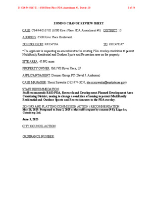
ZONING CHANGE REVIEW SHEET CASE: C14-94-0167.01 (6500 River Place PDA Amendment #1) DISTRICT: 10 ADDRESS: 6500 River Place Boulevard ZONING FROM: R&D-PDA TO: R&D-PDA* *The applicant is requesting an amendment to the existing PDA overlay conditions to permit Multifamily Residential and Outdoor Sports and Recreation uses on the property. SITE AREA: 47.992 acres PROPERTY OWNER: G&I VII River Place, LP APPLICANT/AGENT: Drenner Group, PC (David J. Anderson) CASE MANAGER: Sherri Sirwaitis (512-974-3057, sherri.sirwaitis@austintexas.gov) STAFF RECOMMEDATION: Staff recommends R&D-PDA, Research and Development-Planned Development Area Combining District, zoning to change a condition of zoning to permit Multifamily Residential and Outdoor Sports and Recreation uses to the PDA overlay. ZONING AND PLATTING COMMISSION ACTION / RECOMMENDATION: May 20, 2025: Postponed to June 3, 2025 at the staff's request by consent (9-0); Lugo-1st, Greenberg-2nd. June 3, 2025 CITY COUNCIL ACTION: ORDINANCE NUMBER: 05 C14-94-0167.01 - 6500 River Place PDA Amendment #1; District 101 of 54 ISSUES: N/A CASE MANAGER COMMENTS: The site under consideration is a 48-acre tract of land located near the southwest intersection of FM 2222 Road and River Place Boulevard. The property was zoned R&D-PDA in 1995 through Ordinance No. 950427-R and is developed with an office park (River Place Corporate Park) that contains seven buildings, with surface parking. There is undeveloped land zoned GR-CO directly to the north. To the south, there are office and single family residential uses that are zoned GO-CO and SF-5. The lots to the east are developed with an automotive repair use, a commercial retail center, a restaurant, financial services and medical office uses. To the west there is undeveloped land in the county. The applicant is requesting a rezoning of the property to amend the existing PDA overlay to permit Multifamily Residential and Outdoor Sports and Recreation uses on the property. The applicant plans to replace two of the existing office buildings on the site by constructing two new multifamily complexes, with publicly accessible outdoor recreation amenities (please see Applicant’s Request Letter – Exhibit C). BASIS OF RECOMMENDATION: 1. The proposed zoning should be consistent with the purpose statement of the district sought. Research and development district is the designation for a research use located on a site with a campus-style design. An R&D district designation may be applied to testing services, research warehousing services, or research assembly services. An R&D district use may not include fabrication, processing, manufacturing, refining, or resource extraction. Planned Development Area combining district is intended for combination with selected commercial and industrial base districts, in order to modify base district provisions as necessary to allow for appropriate industrial and commercial uses or to reflect the terms of a Planned Development Area agreement following annexation of properties subject to such an agreement. 2. The proposed zoning should promote consistency and orderly planning. The proposed rezoning will permit the applicant to add two uses to the PDA overlay to redevelop this property with multifamily uses to increase housing density, with amenities, along a major arterial corridor, FM 2222 Road. The proposed zoning will allow for new housing opportunities in this area of the city near an educational institution, Concordia University, which is located on FM 620 to the north adjacent to supporting retail services, Four Points Centre and River Place Center along FM 2222 Road. 05 C14-94-0167.01 - 6500 River Place PDA Amendment #1; District 102 of 54 The site under consideration is partially within the Four Points Activity Center for Redevelopment in Sensitive Environmental Areas. The property is located within 0.3 miles to River Place Elementary School and River Place Elementary School Park. EXISTING ZONING AND LAND USES: ZONING R&D-PDA Site North GR-CO South GO-CO, SF-5 East GR-CO,SF-2, LO, GR-CO, GR, LO West GR-CO, County LAND USES Office (River Place Corporate Park) Undeveloped Office (6414 River Place), Single-Family Residences Automotive Repair (Paul’s Motor Works), Undeveloped Parcel, Retail Center (2222 Station at River Place), Restaurant (Shuck Me), Financial Services (United Heritage Credit Union), Medical Office (River Place Medical), Day Care Services (Kido International Preschool) Undeveloped NEIGHBORHOOD PLANNING AREA: N/A WATERSHED: Panther Hollow, Lake Travis CAPITOL VIEW CORRIDOR: N/A SCENIC ROADWAY: Yes HILL COUNTRY ROADWAY: 2222 Hill Country Roadway NEIGHBORHOOD ORGANIZATIONS: 2222 Coalition of Neighborhood Associations, Inc., Alicante Townhomes, Austin Lost and Found Pets, Canyon Creek H.O.A., Friends of Austin Neighborhoods, Glenlake Neighborhood Association, Leander ISD Population and Survey Analysts, Long Canyon Homeowners Assn., Long Canyon Phase II & III Homeowners Assn Inc., Neighborhood Empowerment Foundation, River Place HOA, SELTexas, Save Our Springs Alliance, Sierra Club, Austin Regional Group, Steiner Ranch Community Association, Steiner Ranch Neighborhood Association, TNR BCP - Travis County Natural Resources, 05 C14-94-0167.01 - 6500 River Place PDA Amendment #1; District 103 of 54 Westminster Glen HOA SCHOOLS: Leander I.S.D. AREA CASE HISTORIES: NUMBER REQUEST COMMISSION CITY COUNCIL GR-CO to GR-MU C14-2020-0078 (High Pointe 620 at 2222: 6701 North FM 620 Road) 4/20/2021: Approved staff’s rec. of GR-MU by consent (9-0, J. Kiolbassa-absent); H. Smith- 1st, D. King-2nd. LO and GR to GR C14-2013-0109 (River Place Center – Lot 7A: 10819 FM 2222 Rd) C14-2008-0027 (River Place Center: 10815 FM 2222 Rd) C14-03-0043 (11000 FM 2222 Rd) Tract 1: LO to GR and Tract 2: LO to GR, to remove an existing site plan on the property I-RR to GR-CO 11/19/2013: Approved staff rec. for GR-CO, with CO to limit the site to 2,100 vtpd and prohibit Custom Manufacturing, Alternative Financial Services, Automotive Rentals, Automotive Repair Services, Automotive Sales, Automotive Washing (of any type), Bail Bond Services, Commercial Off-Street Parking, Drop-Off Recycling Collection Facility, Exterminating Services, Food Sales, Funeral Services, General Retail Services (Convenience), Guidance Services, Off-Site Accessory Parking, Pawn Shop Services, Pedicab Storage and Dispatch and Service Station uses, on consent (7-0); P. Seeger-1st, G. Rojas-2nd. 2/19/2008: Approved staff’s rec. of LO and GR zoning by consent (5-0, K. Jackson- arrived late, J. Martinez and T. Rabago-absent); C. Hammond, J. Shieh-2nd. 3/04/2003: Approved staff rec. of GO-CO zoning by consent (8-0, M. Whaley-absent). 5/06/21: The public hearing was conducted and a motion to close the public hearing and approve Ordinance No. 20210506-058 for community commercial-mixed use (GR- MIT) combining district zoning was approved on Council Member Kelly's motion, Mayor Pro Tem Harper-Madison's second on an 11-0 vote. 12/12/2013: The public hearing was conducted and the motion to close the public hearing and adopt Ordinance No. 20131212- 111 for community commercial -conditional overlay (GR-CO) combining district zoning was approved on consent on Council Member Spelman’s motion, Mayor Pro Tem Cole’s second on a 7-0 vote. 3/20/2008: Ordinance No. 20080320-065 for community commercial (GR) district zoning for Tract 1, and limited office (LO) district zoning and community commercial (GR) district zoning for Tract 2 was approved. 8/28/2003: Approved Ordinance No. 030828-57 05 C14-94-0167.01 - 6500 River Place PDA Amendment #1; District 104 of 54 C14-01-0040 (River Place Office Site) GR-CO to GR- CO, condition is FAR of 0.0402:1 to allow 2.644 acres of development 5/01/2001: Approved GR-CO zoning, with conditions (9-0). 7/30/2001: Approved Ordinance No. 010719-124 RELATED CASES: C14-94-0167 – Previous Zoning Case OTHER STAFF COMMENTS: Comprehensive Planning Project Name and Proposed Use: RIVER PLACE BOULEVARD. C14-94-0167. Project: 6500 River Place. The applicant is requesting a PDA Amendment for this 47.99 acre site. Existing: 590,000 square feet of office space. Proposed: unspecified number of multifamily units located in two new multifamily buildings replacing two existing office buildings, and publicly accessible outdoor recreation amenities. Note that insufficient information is provided to determine the Housing Choice and Housing Affordability measures at this time. Yes Y Imagine Austin Decision Guidelines Complete Community Measures * Imagine Austin Growth Concept Map: Located within or adjacent to an Imagine Austin Activity Center, Imagine Austin Activity Corridor, or Imagine Austin Job Center as identified the Growth Concept Map. Names of Activity Centers/Activity Corridors/Job Centers *: • Partially within the Four Points Activity Center for Redevelopment in Sensitive Environmental Areas Mobility and Public Transit *: Located within 0.25 miles of public transit stop and/or light rail station. Y Mobility and Bike/Ped Access *: Adjoins a public sidewalk, shared path, and/or bike lane. • Sidewalks present along River Pl Blvd, Bonaventure Blvd, and FM 2222. Y Connectivity, Good and Services, Employment *: Provides or is located within 0.50 miles to goods and services, and/or employment center. • Goods and services present along FM 2222. The site offers employment opportunities, including those associated with semiconductor manufacturing. Connectivity and Food Access *: Provides or is located within 0.50 miles of a grocery store/farmers market. Y Connectivity and Education *: Located within 0.50 miles from a public school or university. • 0.3 miles to River Place Elementary School (Leander ISD) Y Connectivity and Healthy Living *: Provides or is located within 0.50 miles from a recreation area, park or walking trail. • 0.3 miles to River Place Elementary School Park Y Connectivity and Health *: Provides or is located within 0.50 miles of health facility (ex: hospital, urgent care, doctor’s office, drugstore clinic, and/or specialized outpatient care.) • 0.5 miles to dentist and orthodontist located along FM 2222. Housing Choice *: Expands the number of units and housing choice that suits a variety of household sizes, incomes, and lifestyle needs of a diverse population (ex: apartments, triplex, granny flat, 05 C14-94-0167.01 - 6500 River Place PDA Amendment #1; District 105 of 54 live/work units, cottage homes, and townhomes) in support of Imagine Austin and the Strategic Housing Blueprint. Housing Affordability *: Provides a minimum of 10% of units for workforce housing (80% MFI or less) and/or fee in lieu for affordable housing. Mixed use *: Provides a mix of residential and non-industrial uses. Culture and Creative Economy *: Provides or is located within 0.50 miles of a cultural resource (ex: library, theater, museum, cultural center). Culture and Historic Preservation: Preserves or enhances a historically and/or culturally significant site. Creative Economy: Expands Austin’s creative economy (ex: live music venue, art studio, film, digital, theater.) Workforce Development, the Economy and Education: Expands the economic base by creating permanent jobs, especially in industries that are currently not represented in a particular area or that promotes a new technology, and/or promotes educational opportunities and workforce development training. Industrial Land: Preserves or enhances industrial land. Not located over Edwards Aquifer Contributing Zone or Edwards Aquifer Recharge Zone 6 Number of “Yes’s” Drainage The developer is required to submit a pre- and post-development drainage analysis at the subdivision and site plan stage of the development process. The City’s Land Development Code and Drainage Criteria Manual require that the Applicant demonstrate through engineering analysis that the proposed development will have no identifiable adverse impact on surrounding properties. Environmental No comments. Fire No comments. Parks and Recreation Parkland dedication will be required for the new applicable uses proposed by this development, (multifamily) with proposed R&D-PDA zoning, at the time of subdivision or site plan, per City Code § 25-1-601. Whether the requirement shall be met with fees in-lieu or dedicated land will be determined using the criteria in City Code Title 25, Article 14, as amended. Should any fees in-lieu be required, those fees shall be used toward park investments in the form of land acquisition and/or park amenities within the surrounding area, per the Parkland Dedication Operating Procedures § 14.3.11 and City Code § 25-1-609. Residential units that are certified affordable and income-restricted are exempt from the parkland dedication requirements per City Code § 25-1-601(D)(4). Parkland dedication will 05 C14-94-0167.01 - 6500 River Place PDA Amendment #1; District 106 of 54 be required for any new market-rate residential units that may be proposed by this development, at the time of subdivision or site plan, per City Code § 25-1-601. If the applicant wishes to discuss parkland dedication requirements in advance of site plan or subdivision applications, please contact this reviewer: ann.desanctis@austintexas.gov. At the applicant’s request, PARD can provide an early determination of whether fees in-lieu of land will be allowed. Site Plan No site plan comments at this time. Site plan comments will be made at time of filing for the site plan permit. Hill Country Roadways Overlay: RM 2222/Moderate Intensity Scenic Roadways Overlay: RM 2222 Road Wildland Urban Interface: Proximity Class - Within 150 feet of a wildland area Transportation Please provide a completed copy of the TIA determination worksheet that has been reviewed and signed by a TPW engineer. The TIA determination worksheet must be submitted via https://atd.knack.com/development-services#customer-portal/services/traffic-impact- analysis-determination/ and it must be not older than 6 months. U1: Comment cleared. TIA Determination Worksheet received. The Austin Strategic Mobility Plan (ASMP) calls for 72 feet of right-of-way for River Place Blvd. It is recommended that 36 feet of right-of-way from the existing centerline should be dedicated for River place Blvd according to the Transportation Plan with the first subdivision or site plan application. [LDC 25-6-51 and 25-6-55]. The adjacent street characteristics table is provided below: Name ASMP Classification ASMP Required ROW Existing ROW Existing Pavement Sidewalks Bicycle Route Capital Metro (within ¼ mile) Level 2 72 feet Approx 91 feet Approx 60 feet Yes No No River Place Blvd (A portion of property abuts Hill Country Roadway) 05 C14-94-0167.01 - 6500 River Place PDA Amendment #1; District 107 of 54 Water Utility The landowner intends to serve the site with City of Austin water and wastewater utilities. The landowner, at own expense, will be responsible for providing any water and wastewater utility improvements, offsite main extensions, utility relocations and or abandonments required by the land use. The site shall have separate wastewater taps, separate water meters, and their respective private water and wastewater service lines shall be positioned or located in a manner that will not cross lot lines. Depending on the development plans submitted, water and or wastewater service extension request revisions to approved service extension requests may be required. The water and wastewater utility plan must be reviewed and approved by Austin Water for compliance with City criteria. All water and wastewater construction must be inspected by the City of Austin. The landowner must pay the City inspection fee with the utility construction. The landowner must pay the tap and impact fee once the landowner makes an application for a City of Austin water and wastewater utility tap permit. All new development within the proposed project will be subject to City Code Chapter 25-9 and any future amendments relating to reclaimed water connections, water benchmarking, and mandatory onsite water reuse. FYI: Dedication of private streets and public utility easements does not obligate the City to approve the placement of City water and wastewater mains within same. Water and wastewater service shall be provided to each lot at their Right of Way frontage. INDEX OF EXHIBITS TO FOLLOW A: Zoning Map B. Aerial Map C. Applicant’s Request Letter D. Redlined R&D PDA Ordinance 05 C14-94-0167.01 - 6500 River Place PDA Amendment #1; District 108 of 54 GR-MU C14-2020-0078 92-0124 C14-01-0040 01-0040 GR-CO C14-98-0225 GR-MU-CO I-SF-2 BOAT\REPAIR/\SALE C814-95-0002.04 C814-95-0002.11 PUD C814-95-0002.10 UNDEV C14-03-0073 GR-CO EXHIBIT A CS-CO 98-0214 C14-98-0214 AUTO\REPAIR 98-0214 ! ! ! ! ! ! ! GR-CO C14-03-0043 ( 03-0043 99-2075 GO-CO BOAT STORAGE SERVICE\STATION I-SF-2 F M 2 2 2 2 R D LO C14-2015-0122 2008-0027 R84-237 GR C14-2012-0142 ! AUTO\REPAIR ! ! ! ! ! ! ! GR-CO C14-2012-0094 SF-2 85-13 88-42 C7A-00-006 ! ! ! ! ! ! ! ! ! ! ! ! R&D R I V E R P L A C E B L V D R&D SP-04-0124D ! ! ! ! ! ! ! ! ! ! ! ! ! ! ! ! ! ! ! ! ! ! 92-124 ! ! ! ! ! ! ! ! ! ! ! 94-0167 SP-98-0280C ! R&D-PDA ! ! ! ! ! ! ! ! ! ! ! ! ! ! ! ! ! ! ! ! ! ! ! ! ! ! ! ! ! GO-CO 94-0167 92-0124 SF-5 GR-CO ! C14-2013-0109 ! ! ! ! ! ! ! ! ! ! ! ! C14R-85-394(DE) C14-2008-0027 LO 84-237 2008-0027 GR 85-394 GR ! ! ! ! ! ! ! ! ! ! C14-97-0083 LR-CO 97-0083 ! ! GR-CO 95-0193 GR C14-95-0193 SPC-04-0007C 05-0075 C14-05-0075 9 4 -0 1 6 7 ! ! ! ! ! ! ! ! 94-0167 ! ! 92-0124 ! ! ! ! 92-0124 SPC-05-0015C ! ! ! ! ! ! ! ! ! B ! O N GR-CO C14-04-0063 SF-5 92-126 ! ! ! A V E N T U R E D R SP-01-0482C C14-99-2130 00-2144 99-2130 99-0128 SP-99-0126C C14-05-0212 P C14R-87-073 94-0167 C14-00-2144 00-2144 NO-CO SP-01-0482C SP-05-1300C C14-99-0128 99-0128 C14-01-0121 99-2130 DR SUBJECT TRACT ! ! ! ! ! ! PENDING CASE ZONING BOUNDARY ± ZONING ZONING CASE#: C14-94-0167 This product is for informational purposes and may not have been prepared for or be suitable for legal, engineering, or surveying purposes. It does not represent an on-the-ground survey and represents only the approximate relative location of property boundaries. 1 " = 400 ' This product has been produced by the Planning Department for the sole purpose of geographic reference. No warranty is made by the City of Austin regarding specific accuracy or completeness. Created: 1/22/2025 05 C14-94-0167.01 - 6500 River Place PDA Amendment #1; District 109 of 54 EXHIBIT B !!!!!!!!!!!!!!!!!!!!!!!!!!!!!!!!!!!!!!!!!!!!!!!!!!!!!!!!!!!!!!!!!!!!!!!!!!!!!!!!!!!!!!!!!!!!!!!!!!!!!!!!!!!!!!!!!!!!!!!!!!!!!!!!!!!!!!!!!!!!!!!(C14-94-0167C14-01-0040C14-2008-0027C14-04-0063C14-2020-0078C14-99-2130C14-2013-0109C814-95-0002.10C14-98-0225C814-95-0002.11C814-95-0002.04C14-99-0128C14-98-0214C14-01-0121C14-2015-0122C14-95-0193C14-00-2144C14-03-0043C14-2012-0094C14-03-0073C14-97-0083C14-2012-0142C14-05-0212C14-05-0075FM2222RDRIVERPLACEBLVDBONAVENTURE DRR&D-PDASF-5GR-CONO-COR&DLOGRGO-COGO-COPUDDRGR-MUGR-COR&DGR-COGRGR-MU-COLOI-SF-2GRGR-COGR-COSF-2SF-5GR-COCS-COGR-COLR-COPI-SF-2GR6500 River Place±This product has been produced by Planning Department for the sole purpose of geographic reference. No warranty ismade by the City of Austin regarding specific accuracy or completeness.ZONING CASE#:LOCATION:SUBJECT AREA:MANAGER:C14-94-01676500 River Place Blvd47.992 AcresSherri SirwaitisCreated: 2/25/2025SUBJECT TRACTZONING BOUNDARY!!!PENDING CASECREEK BUFFERImageRGBRed: Band_1Green: Band_2Blue: Band_31inchequals400'05 C14-94-0167.01 - 6500 River Place PDA Amendment #1; District 1010 of 54 EXHIBIT C Via Electronic Delivery November 13, 2024 Ms. Lauren Middleton-Pratt Planning Department City of Austin 6310 Wilhelmina Delco Dr. Austin, TX 78752 RE: 6500 River Place – PDA Amendment application for the 47.992-acre tract of land located at 6500 River Place Boulevard in Austin, Travis County, Texas (the “Property”) Dear Ms. Middleton-Pratt: As representatives of the owner of the Property, we respectfully submit the enclosed PDA amendment application package for review. The project, titled 6500 River Place, consists of 47.99 acres and is located at 6500 River Place Boulevard in the full purpose jurisdiction of the City of Austin. The Property is zoned Research & Development – Planned Development Area (“R&D-PDA”), via City of Austin Case No. C14-94-0167. The requested PDA amendment is to add multifamily and outdoor recreation as permissible uses. The Property is currently developed with over 590,000 square feet of office space. The purpose of this amendment is to allow for new multifamily development which will include publicly accessible outdoor amenities such as pickleball courts, green space, a play area, and parking, and bring additional housing to the area. The two new multifamily buildings will replace two existing office buildings, with no increase in impervious cover. The proposed development will comply with the site development standards established in the existing PDA, as well as the Hill Country Roadway Corridor requirements. As determined by the PDA, all uses and accessory uses allowed in the Property’s zoning category are permitted by the site development standards of the PDA. The R&D district is subject to the PDA requirements of the Land Development Code (“LDC”) in effect at the time of its approval. The requested amendment is consistent with the surrounding land uses, as there are multifamily developments to the north and south of the Property. The Property is not located within a City of Austin neighborhood planning area; therefore, a neighborhood plan amendment will not be required in conjunction with this application. Please let me know if you or your team members require additional information or have any questions. Thank you for your time and attention to this project. Sincerely, David J. Anderson, P.E., BC.WRE, CFM, CPESC Cc: Joi Harden, Planning Department (via electronic delivery) 2705 Bee Caves Road, Suite 100 | Austin, Texas 78746 | 512-807-2900 | www.drennergroup.com 05 C14-94-0167.01 - 6500 River Place PDA Amendment #1; District 1011 of 54 CITY OF AUSTIN, TEXAS ORDINANCE NO. 950427- R EXHIBIT D AN ORDINANCE ORDERING A REZONING AND CHANGING THE ZONING MAP ACCOMPANYING CHAPTER 13-2 OF THE AUSTIN CITY CODE OF 1992 TO ESTABLISH A "PDA" PLANNED DEVELOPMENT AREA COMBINING DISTRICT AND "CO" CONDITIONAL OVERLAY COMBINING DISTRICT IN COMBINATION WITH CERTAIN OF THE BASE DISTRICT ZONING CLASSIFICATIONS ESTABLISHED BY THIS ORDINANCE, AS FOLLOWS: TRACT 1: 99.62 ACRE TRACT OF LAND OUT OF THE BANYAN PAYNE SURVEY NO. 288, ABSTRACT 640; THE WILLIAM BELL SURVEY NO. 802, ABSTRACT 112; AND, THE RICHARD L. PREECE SURVEY NO. 2, ABSTRACT 2269, FROM "SF-5" URBAN FAMILY RESIDENCE DISTRICT AND "MF-2" MULTIFAMILY RESIDENCE (LOW DENSITY) DISTRICT TO "R&D-PDA" RESEARCH AND DEVELOPMENT DISTRICT-PLANNED DEVELOPMENT AREA COMBINING DISTRICT; AND, TRACT 2: 52.37 ACRE TRACT OF LAND OUT OF THE BANYAN PAYNE SURVEY NO. 288, ABSTRACT 640; AND, THE LOUIS FRITZ SURVEY NO. 291, ABSTRACT 280, FROM "MF-2" MULTIFAMILY RESIDENCE (LOW DENSITY) DISTRICT TO "GR-CO" COMMUNITY COMMERCIAL DISTRICT-CONDITIONAL OVERLAY COMBINING DISTRICT; AND, TRACT 3: 13.37 ACRE TRACT OF LAND OUT OF THE BANYAN PAYNE SURVEY NO. 288, ABSTRACT 640; AND, THE RICHARD L. PREECE SURVEY NO. 2, ABSTRACT 2269, FROM "SF-5" URBAN FAMILY RESIDENCE DISTRICT AND "MF-2" MULTIFAMILY RESIDENCE (LOW DENSITY) DISTRICT TO "GO-CO" GENERAL OFFICE DISTRICT-CONDITIONAL OVERLAY COMBINING DISTRICT; AND, TRACT 4: 1.11 ACRE TRACT OF LAND OUT OF THE WILLIAM BELL SURVEY NO. 802, ABSTRACT 112, FROM "SF-5" URBAN FAMILY RESIDENCE DISTRICT TO "GR-CO" COMMUNITY COMMERCIAL DISTRICT-CONDITIONAL OVERLAY COMBINING DISTRICT; AND, TRACT 5: 0.345 ACRE TRACT OF LAND OUT OF THE ALEXANDER DUNLAP SURVEY NO. 805, ABSTRACT 224, FROM "SF-2" SINGLE-FAMILY RESIDENCE (STANDARD LOT) DISTRICT TO "R&D-PDA" RESEARCH AND DEVELOPMENT DISTRICT-PLANNED DEVELOPMENT AREA COMBINING DISTRICT, LOCALLY KNOWN AS THE PROPERTY IDENTIFIED IN THE MAP ATTACHED AS "EXHIBIT F" TO THIS ORDINANCE, IN THE CITY OF AUSTIN, TRAVIS COUNTY, TEXAS; WAIVING THE REQUIREMENTS OF SECTIONS 2-2-3, 2-2-5, AND 2-2-7 OF THE AUSTIN CITY CODE OF 1992; AND DECLARING AN EMERGENCY. BE IT ORDAINED BY THE CITY COUNCIL OF THE CITY OF AUSTIN: PART 1. That Chapter 13-2 of the Austin City Code of 1992 is amended to change the respective base zoning district classification on each of the following tracts described in File C14-94-0167, and to establish a Planned Development Area combining district and Conditional Overlay combining district on each of the following tracts, as follows: Page 1 of3 05 C14-94-0167.01 - 6500 River Place PDA Amendment #1; District 1012 of 54 CITY OF AUSTIN, TEXAS Tract 1: From "SF-5" Urban Family Residence district and "MF-2" Multifamily Residence (Low Density) district to "R&D-PDA" Research and Development district-Planned Development Area combining district. 99.62 acre tract of land out of the Banyan Payne Survey No. 288, Abstract 640; William Bell Survey No, 802, Abstract 112; and, Richard L. Preece Survey No. 2, Abstract 2269, said 99.62 acre tract of land being more particularly described by metes and bounds in "Exhibit A" attached and incorporated herein for all purposes. Tract 2: From"MF-2" Multifamily Residence (Low Density) district to "GR-CO" Community Commercial district-Conditional Overlay combining district. 52.37 acre tract of land out of the Banyan Payne Survey No. 288, Abstract 640; and, the Louis Fritz Survey No. 291, Abstract 280, said 52.37 acre tract of land being more particularly described by metes and bounds in "Exhibit B" attached and incorporated herein for all purposes. Tract 3: From "SF-5" Urban Family Residence district and "MF-2" Multifamily Residence (Low Density) district to "GO-CO" General Office district-Conditional Overlay combining district. 13.37 acre tract of land out of the Banyan Payne Survey No. 288, Abstract 640; and, the Richard L, Preece Survey No. 2, Abstract 2269, said 13.37 acre tract of land being more particularly described by metes and bounds in "Exhibit C" attached and incorporated herein for all purposes. Tract 4: From "SF-5" Urban Family Residence district to "GR-CO" Community Commercial district-Conditional Overlay combining district. 1.11 acre tract of land out of the William Bell Survey No. 802, Abstract 112, said 1.11 acre tract of land being more particularly described by metes and bounds in "Exhibit D" attached and incorporated herein for all purposes. Tract 5: From "SF-2" Single-Family Residence (Standard Lot) district to "R&D-PDA" Research and Development district-Planned Development Area combining district. 0.345 acre tract of land out of the Alexander Dunlap Survey No. 805, Abstract 224, said 0.345 acre tract of land being more particularly described by metes and bounds in "Exhibit E" attached and incorporated herein for all purposes. [hereinafter referred to as the "Property"] locally known as the Property identified in the map attached as "Exhibit F" to this ordinance, in the City of Austin, Travis County, Texas. PART 2. That the property described in PART 1 of this ordinance as Tracts 2 through 4, and being within the boundaries of the Conditional Overlay combining district established by this PART 1 shall be subject to the following restrictions: 1. Development of Tract 2 shall be restricted to a maximum floor to area ratio of 0.025 to 1. Page 2 of3 05 C14-94-0167.01 - 6500 River Place PDA Amendment #1; District 1013 of 54 CITY OF AUSTIN, TEXAS 2. 3. Development of Tract 3 shall be restricted to a maximum floor to area ratio of 0.14 to 1. Development of Tract 4 shall be restricted to a maximum floor to area ratio of 0.10 to 1. Except as specifically restricted by this ordinance, the property described in PART 1 of this ordinance as Tracts 2 through 4, may be developed and used in accordance with regulations established for the respective base districts and other applicable requirements of the Land Development Code. PART 3. That the property described in PART 1 of this ordinance as Tracts 1 and 5, and being within the boundaries of the "PDA" Planned Development Area combining district established by PART 1 of this ordinance shall conform to the site development limitations and conditions as set forth in the "SITE DEVELOPMENT STANDARDS" attached as "Exhibit G" to this ordinance. PART 4. That it is ordered that the Zoning Map established by Section 13-2-22 of the Austin City Code of 1992 and made a part thereof shall be changed to record the amendment enacted by this ordinance. PART 5. That the requirements imposed by Sections 2-2-3, 2-2-5, and 2-2-7 of the Austin City Code of 1992, as amended, regarding the presentation and adoption of ordinances are hereby waived by the affirmative vote of at least five members of the City Council. PART 6. The City Council declares that an emergency exists concerning the safe, orderly, and healthful growth and development of the City in order to assure the immediate preservation of the public peace, health, and safety; therefore, this ordinance shall become effective immediately upon its passage as required by this emergency and as provided by the City Charter of the City of Austin. PASSED AND APPROVED: § April 27 § , 1995 § APPROVED: j / ** ^J Andrew Martin City Attorney ATTEST: ( Bruce Todd Mayor £ James E. Aldridge City Clerk 27Apr95 ME/jj Page 3 of3 05 C14-94-0167.01 - 6500 River Place PDA Amendment #1; District 1014 of 54 99.62 Acres Zoning Tract ) River Place F.N. 5019R1 (JMC) March 1, 1995 SRI Job No. 2400-08 A DESCRIPTION OF A 99.62 ACRE TRACT OF LAND OUT OF THE BANYAN PAYNE SURVEY NO. 288 ABSTRACT 640, WILLIAM BELL SURVEY NO. 802 ABSTRACT 112, AND THE RICHARD L. PREECE SURVEY NO. 2 ABSTRACT 2269 IN TRAVIS COUNTY, TEXAS, BEING A PORTION OF THAT CERTAIN 1441.33 ACRE TRACT AS DESCRIBED IN THAT DEED FROM SOUTHWEST FEDERAL SAVINGS ASSOCIATION TO FIRST RIVER PLACE RESERVE LTD. AND RECORDED IN VOLUME 11379 PAGE 379 OF THE DEED RECORDS OF TRAVIS COUNTY, TEXAS; SAID 99.62 ACRE TRACT AS SHOWN ON THE ACCOMPANYING SKETCH, BEING MORE PARTICULARLY DESCRIBED BY METES AND BOUNDS AS FOLLOWS: COMMENCING at an iron rod found in the existing south right-of-way line of Ranch to Market Road 2222 (100-foot wide right-of-way), said iron rod being the northwest corner of River Place Section 1, a subdivision recorded in Book 84, Pages 103A through 105B of the Plat Records of Travis County, Texas; THENCE with the common line of said River Place Section 1 and River Place Center, a subdivision recorded in Book 86 Pages 196A through 196C of said Plat Records, S 29" 43' 03* W, passing at 560.05 feet the southeast corner of said River Place Center, being the northeast corner of that certain 0.6114 acre tract of land described in a deed to Four Points Development Co., L.C., recorded in Volume 12155, Page 3925 of the Deed Records of Travis County, Texas, in all a distance of 790.05 feet to a 1/2-inch iron rod found on a south line of said River Place Section 1 being the southeast comer of said 0.6114 acre tract; THENCE with said south line of River Race Section 1, S 47" 22' 51" E, a distance of 103.55 feet to a 1/2-inch iron rod in concrete found in the west right-of-way line of River Race Boulevard (90- foot wide right-of-way) a street dedicated by said plat of River Place Section 1; THENCE with the said west right-of-way line of River Place Boulevard, S 37" 2V 11* W, a distance of 145.61 feet to the POINT OF BEGINNING of herein described 99.62 acre tract; THENCE continuing with said west line of River Place Boulevard, S 37" 2V 11" W, a distance of 166.44 feet to a 1/2-inch iron set at a point of curvature to the right; THENCE departing said west line of River Place Boulevard, a distance of 23.56 feet along the arc of said curve to the right having a central angle of 90" 00' 00", a radius of 15.00 feet and whose chord bears S 82" 2V 11" W, a distance of 21.21 feet to a 1/2-inch iron rod set at the point of tangency in the north right-of-way line of Bonaventure Drive, (70-foot wide right-of-way) a street dedicated by said plat of River Place Section 1 ; THENCE with the said north right-of-way line of Bonaventure Drive, N 52" 38' 49" W, a distance of 52.97 feet to a 1/2-inch iron rod found at a point of curvature to the right, said point being in a north line of River Place Municipal Utility District (M.U.D.); THENCE with the said north line of River Place M.U.D., the following two (2) courses and distances: 1. a distance of 187.18 feet with the arc of said curve to the right having a central angle of 22" 06' 45", a radius of 485.00 feet, and whose chord bears N 41 * 35' 26* W, a distance of 186.02 feet to the point of tangency. and 2. N 30' 32' 04" W, a distance of 125.51 feet to a point; Page 1 of 5 "Exhibit A" . 05 C14-94-0167.01 - 6500 River Place PDA Amendment #1; District 1015 of 54 99.62 Acres Zoning Tract I River Place F.N. 5019R1 (JMC) March 1, 1995 SRI'Job No. 2400-08 THENCE with an east line of said River Place M.U.D., S 59" 27' 56" W, a distance of 70.00 feet to a point in a south line of said River Place M.U.D.; THENCE with the said south line of River Race M.U.D., the following two (2) courses and distances: 1. 2. S 30' 32' 04* E, a distance of 125.51 feet to a point of curvature to the left, and a distance of 214.19 feet along the arc of said curve to the left having a central angle of 22" 06' 45", a radius of 555.00 feet and whose chord bears S 41" 35' 26* E. a distance of 212.87 feet to a PK nail set in the south right-of- way line of said Bonaventure Drive; THENCE with said south right-of-way line of Bonaventure Drive, S 52* 38' 49" E, a distance of 52.97 feet to a 1/2-inch iron rod set at a point of curvature to the right; THENCE departing said south right-of-way line of Bonaventure Drive, a distance of 23.56 feet along the arc of said curve to the right having a central angle of 90" 00' 00", a radius of 15.00 feet, and whose chord bears S 07" 38' 49" E, a distance of 21.21 feet to a 1 /2-inch iron rod set at the point of tangency in the west right-of-way line of the aforementioned River Place Boulevard; THENCE with said west right-of-way line of River Place Boulevard, S 37* 21' 11" W, a distance of 33.87 feet to a 1/2-inch iron rod set at a point of curvature to the left; THENCE continuing with said west right-of-way tine of River Race Boulevard, a distance of 203.59 feet along the arc of said curve to the left having a central angle of 15* 27' 00", a radius of 755.00 feet, and whose chord bears S 29" 37' 41" W, a distance of 202.97 feet to a point on said right-of-way; THENCE departing said west right-of-way line of River Race Boulevard, and crossing said 1441.33 acre tract, the following five (5) courses and distances: 1. 2. 3. 4. 5. N 55" 47' 53" W, a distance of 296.50 feet to a point, N 57' 13' 52" W, a distance of 186.22 feet to a point, S 63" 5V 35" W, a distance of 386.22 feet to a point, N 66" 29' 14" W, a distance of 72.89 feet to a point, and S 80* 46' 59" W, a distance of 1458.52 feet to a point in a south line of said 1441.33 acre tract, being the north line of that certain 1751.95 acre tract of land described in a deed to the City of Austin, recorded in Volume 11848, Page 1718 of the Deed Records of Travis County, Texas; THENCE with said south line of the 1441.33 acre tract, being the north line of said 1751.95 acre tract, N 60" 11' 50" W, a distance of 800.00 feet to a 1 /2-inch iron rod found, from which a 3/4- inch iron pipe found in a rock mound bears N 48* 53' 39" E, a distance of 3.41 feet; Page 2 of 5 "Exhibit A" I 05 C14-94-0167.01 - 6500 River Place PDA Amendment #1; District 1016 of 54 99.62 Acres Zoning Tract I River Place F.N. 5019R1 (JMC) March 1, 1995 SRI Job No. 2400-08 THENCE with the west line of said 1441.33 acre tract, being an east line of said 1751.95 acre tract, N 29" 55' 29" E, a distance of 878.89 feet to a 1/2-inch iron pipe found, from which a 3/4- inch iron pipe found in a rock mound bears S 57' 32' 03" E, a distance of 12.97 feet; THENCE departing the west line of said 1441.33 acre tract, being the east line of said 1751.95 acre tract, and crossing said 1441.33 acre tract, N 46' 55' 50" E, a distance of 1684.03 feet to a 1/2-inch iron set in the south line of a 100-foot wide Lower Colorado River Authority (LCRA) Electric Easement, as recorded in Volume 622, Page 573 of the Deed Records of Travis County, Texas; THENCE with said south line of the LCRA Easement, N 83* 00' 29" E, passing at 654.91 feet a 1/2-inch iron rod found being the southwesterly corner of the Bryan H. Montandon tract as recorded in Volume 9450, Page 944 of the Deed Records of Travis County, Texas, in all a distance of 655.84 feet to a 1/2-inch iron rod set in the northerly line of the said 1441.33 acre tract, same being the southerly line of the Steve Topletz 0.345 acre tract as recorded in Volume 8210, Page 723 of the Deed Records of Travis County, Texas; THENCE with the north line of said 1441.33 acre tract, same being the southerly line of said Topletz tract S 59" 34' 01" E, a distance of 270.92 feet to a 1/2-inch iron rod found at the northwest corner of that certain 0.50 acre tract of land described in that deed to Charles R. Webb, as recorded in Volume 7641, Page 112 of the Deed Records of Travis County, Texas; THENCE with an easterly line of said 1441.33 acre tract being the northwest line of said Webb 0.50 acre tract, S 30" 12' 23" W, a distance of 514.54 feet to a 1/2-inch iron rod found at the southwest comer of said Webb 0.50 acre tract; THENCE with a north line of said 1441.33 acre tract being the southwest line of said Webb 0.50 acre tract, and the southwest line of Bull Creek Place, a subdivision recorded in Book 77, Page 68 of the Plat Records of Travis County, Texas, S 59* 48' 52* E, a distance of 236.58 feet to a 1/2- inch iron rod found for the most southerly comer of said Bull Creek Race, and being in the northwest line of Lot 1 of said River Place Center; THENCE with the west, south and east lines of said Lot 1 of River Place Center, the following seven (7) courses and distances: 1. 2. 3. S 30* 13' 48' W. a distance of 131.45 feet to a 1 /2-inch iron rod found at a non- tangent point of curvature to the right, a distance of 419.68 feet along the arc of said curve to the right, having a central angle of 39* 44' 43*, a radius of 605.00 feet, and whose chord bears S 24* 13' 41' E, a distance of 411.32 feet to a 1/2-inch iron rod found at the point of tangency, S 04* 21' 20" E, a distance of 167.73 feet to a 1 /2-inch iron rod found at a point of curvature to the left. Page 3 of 5 "Exhibit A" 05 C14-94-0167.01 - 6500 River Place PDA Amendment #1; District 1017 of 54 99.62 Acres Zoning Tract | River Place F.N. 5019R1 (JMC) March 1, 1995 SRI Job No. 2400-08 4. 5. 6. 7. a distance of 208.36 feet along the arc of said curve to the left, having a central angle of 45 "03' 01", a radius of 265.00 feet, and whose chord bears S 26* 52' 50' E, a distance of 203.04 feet to a PK nail found at the point of tangency, S 49" 24' 21* E, a distance of 108.93 feet to a 1/2-inch iron rod found for at a point of curvature to the right, a distance of 129.77 feet along the arc of said curve to the right, having a central angle of 18" 52' 17", a radius of 394.01 feet, and whose chord bears S 39 * 58' 13" E, a distance of 129.19 feet to a 1 /2-inch iron rod found for the end of said curve, and N 51 * 28' 00" E, a distance of 128.32 feet to a point on the east line of said Lot 1 of River Race Center; THENCE leaving the east line of said Lot 1 of River Race Center and crossing said 1441.33 acre tract, S 47* 22' 51" E, a distance of 352.92 feet to the POINT OF BEGINNING and containing 99.62 acres of land. THE STATE OF TEXAS COUNTY OF TRAVIS KNOW ALL MEN BY THESE PRESENTS: That I, David Paul Carr, a Registered Professional Land Surveyor, do hereby certify that the above description is true and correct to the best of my knowledge and belief and that the property described herein was determined by a survey made on the ground during January, 1992 under the direction and supervision of Donald J. Kirby, Registered Professional Land Surveyor No. 2508, and January 1995 under my direction and supervision. WITNESS MY HAND AND SEAL at Austin, Travis County. Texas this the 1 st day of March, 1995, A.D. SURVEY RESOURCES, INC. P.O. Box 162690 Austin, Texas 78716-2690 .oavid Paul Can Registered Professional Land Surveyor No. 3997 - State of Texas Page 4 of 5 "Exhibit A" 05 C14-94-0167.01 - 6500 River Place PDA Amendment #1; District 1018 of 54 GRAPHIC SCALE SCALE : 1 = 500' MARCH. 1995 TRAVIS COUNTY. TEXAS 52.37 ACRES 10O1 WIDC CiSPCNT TO L.C.R.A. VOL.C42. PC.W 0.345 ACRES FN 5037 R & D 62 ACRES FN 5019R1 R & D PONT or \BEGMNNC •^ W 5020 "Exhibit A" 05 C14-94-0167.01 - 6500 River Place PDA Amendment #1; District 1019 of 54 52.37 Acres Zoning Tract *• River Place F.N. 5021R (JMC) March 1, 1995 SRI Job No. 2400-08 A DESCRIPTION OF A 52.37 ACRE TRACT OF LAND OUT OF THE BANYAN PAYNE SURVEY NO. 288 ABSTRACT 640 AND THE LOUIS FRITZ SURVEY NO. 291 ABSTRACT 280 IN TRAVIS COUNTY, TEXAS, BEING A PORTION OF THAT CERTAIN 1441.33 ACRE TRACT OF LAND DESCRIBED IN A DEED FROM SOUTHWEST FEDERAL SAVINGS ASSOCIATION TO RIVER PLACE RESERVE LTD., RECORDED IN VOLUME 11379, PAGE 379 OF THE DEED RECORDS OF TRAVIS COUNTY, TEXAS, SAID 52.37 ACRES AS SHOWN ON THE ACCOMPANYING SKETCH, BEING MORE PARTICULARLY DESCRIBED BY METES AND BOUNDS AS FOLLOWS: COMMENCING at a 1 /2-inch iron rod found at the northwest comer of that certain 0.50 acre tract of land described in a deed to Charles R. Webb, recorded in Volume 7641, .Page 112 of the Deed Records of Travis County, Texas, and being also at the southeast corner of that certain 0.346 acre tract of land described in a deed to Steve Topletz, Trustee, recorded in Volume 8210, Page 723 of the Deed Records of Travis County, Texas; THENCE with the north fine of said 1441.33 acre tract, N 59* 34' 01" W, a distance of 270.92 feet to a 1/2-inch iron rod set in the south line of a 100-foot wide Electric Easement described in a deed to the Lower Colorado River Authority <LCRA), recorded in Volume 622, Page 573 of the Deed Records of Travis County, Texas, from which a 1/2-inch iron rod found bears S 83" 00' 29" W, a distance of 0.92 feet, said iron rod being the southwesterly corner of the Bryan H. Montandon tract as recorded in Volume 9450, Page 944 and Volume 8528, Page 911 of the Deed Records of Travis County, Texas, said 1/2-inch iron rod set being the POINT OF BEGINNING of the herein described 52.37 acre tract; THENCE with the south line of said LCRA Electric Easement, and crossing said 1441.33 acre tract, S 83" 00' 29" W, a distance of 655.84 feet to a 1/2-inch iron rod set; THENCE departing the south line of said LCRA Electric Easement, and continuing across said 1441.33 acre tract, S 46" 55' 50" W, a distance of 1684.03 feet to a 1/2-inch iron pipe found for a comer in the north line of that certain 1751.95 acre tract of land described in a deed to the City of Austin, recorded in Volume 11848, Page 1718 of the Deed Records of Travis County, Texas, from which a 3/4-inch iron pipe found in a rock mound bears S 57* 32' 03" E, a distance of 12.97 feet; THENCE with the said north line of the 1751.95 acre tract being the south line of the said 1441.73 acre tract, N 59" 49' 11" W, passing at 1637.57 feet, a 1/2-inch iron rod found and continuing for a total distance of 1650.55 feet to a point in the existing east right-of-way line of Ranch to Market Road 620; THENCE with said east right-of-way line of R.M. 620, being a west line of said 1441.33 acre tract, the following two (2) courses and distances: 1. 2. N 71" 44' 51" E, a distance of 860.17 feet to a 1 /2-inch iron rod found lor a point of curvature to the left, and a distance of 486.68 feet along the arc of said curve to the left, having a central angle of 42" 4V 44", a radius of 653.11 feet and whose chord bears N 50" 24' 00" E, a distance of 475.50 feet to a point in the north line of a 100- foot wide Electric Easement described in a deed to LCRA, recorded in Volume 642, Page 493 of the Deed Records of Travis County, Texas; Page 1 of 3 "Exhibits" I 05 C14-94-0167.01 - 6500 River Place PDA Amendment #1; District 1020 of 54 52.37 Acres Zoning Tract "*- River Place F.N. 5021 R (JMC) March 1 , 1 995 SRI Job No. 2400-08 THENCE departing the east right-of-way line of said R.M. 620, with the westerly line of said LCRA 1 00-foot wide easement, N 83 " 03' 44" E, a distance of 1 528. 1 9 feet to a point in the north line of the said 1441 .23 acre tract; THENCE departing the westerly line of said LCRA Easement, with said north line of the 1441.33 acre tract same being the south line of the said Bryan H. Montandon tract, S 59* 34' 01" E, a distance of 707.51 feet to the POINT OF BEGINNING and containing 52.37 acres of land. THE STATE OF TEXAS COUNTY OF TRAVIS KNOW ALL MEN BY THESE PRESENTS: That I, David Paul Carr, a Registered Professional Land Surveyor, do hereby certify that the above description is true and correct to the best of my knowledge and belief and that the property described herein was determined by a survey made on the ground during January, 1992 under the direction and supervision of Donald J. Kirby, Registered Professional Land Surveyor No. 2508, and January, 1995 under my direction and supervision. WITNESS MY HAND AND SEAL at Austin, Travis County, Texas this the 1st day of March, 1995, A.D. SURVEY RESOURCES, INC. P.O. Box 162690 Austin, Texas 78716-2690 /**• * .^'t... vCSvkJ Paul Carr "nivnn*Pfti;i' ".i^/Registered Professional Land Surveyor No. 3997 - State of Texas Page 2 of 3 "Exhibits" 05 C14-94-0167.01 - 6500 River Place PDA Amendment #1; District 1021 of 54 SCALE : 1" = 500' MARCH, 1995 TRAVIS COUNTY. TEXAS 52.37 ACRES FN 5021R GR 13.37 ACRES FN 5036 GO 0.345 ACRES FN 5037 R & D 99.62 ACRES FN 5019R1 R & D POWT OF \BCONMNC -" ^3020 1.11 A C R E S - - - -- . FN 5020R SURVEY HEBOURCeB NC. <m> tm-tua "Exhibits'1 05 C14-94-0167.01 - 6500 River Place PDA Amendment #1; District 1022 of 54 13.37 Acres Zoning Tract 3 River Place F.N. 5036 (JAY) March 1, 1995 SRI Job No. 2400-08 A DESCRIPTION OF A 13.37 ACRE TRACT OF LAND OUT OF THE BANYAN PAYNE SURVEY NO. 288 ABSTRACT 640. AND THE RICHARD L. PREECE SURVEY NO. 2 ABSTRACT 2269 IN TRAVIS COUNTY, TEXAS, BEING A PORTION OF THAT CERTAIN 1441.33 ACRE TRACT AS DESCRIBED IN THAT DEED FROM SOUTHWEST FEDERAL SAVINGS ASSOCIATION TO FIRST RIVER PLACE RESERVE LTD. AND RECORDED IN VOLUME 11379 PAGE 379 OF THE DEED RECORDS OF TRAVIS COUNTY, TEXAS; SAID 13.37 ACRE TRACT AS SHOWN ON THE ACCOMPANYING SKETCH, BEING MORE PARTICULARLY DESCRIBED BY METES AND BOUNDS AS FOLLOWS: COMMENCING at a 1/2-inch iron rod found at the end of return from the south right-of-way line of Bonaventure Drive being on the west right-of-way line of River Place Boulevard (90-foot wide right-of-way), both streets dedicated by River Place Section 1, a subdivision recorded in Book 84, Pages 103A through 105B of the Plat Records of Travis County, Texas; THENCE with said west right-of-way line of River Place Boulevard, S 37" 2V 11" W, a distance of 33.87 feet to a 1/2-inch iron rod set at a point of curvature to the left; THENCE continuing with said west right-of-way line of River Place Boulevard, a distance of 203.59 feet along the arc of said curve to the left having a central angle of 15" 27' 00", a radius of 755.00 feet, and whose chord bears S 29* 37' 41' W, a distance of 202.97 feet to the POINT OF BEGINNING of herein described 13.37 acre tract; THENCE continuing with said west right-of-way line of River Place Boulevard, the following three (3) courses: 1. 2. 3. a distance of 126.90 feet along the arc of said curve to the left having a central angle of 09" 37' 50", a radius of 755.00 feet, and whose chorn bears S 17' 05' 17" W, a distance of 126.75 feet to a 1 /2-inch iron rod set at the point of tangency; S 77" 43' 38" E, a distance of 5.00 feet to a 1/2-inch iron rod found, and S 12" 16' 22" W, a distance of 142.68 feet to a 1/2-inch iron rod found; THENCE departing said west right-of-way line of River Race Boulevard, and crossing said 1441.33 acre tract, the following five (5) courses: 1. N 63' 18' 45" W, • distance of 524.49 feet to a point, 2. 3. 4. 5. S 34" 52' 08* W, a distance of 211.03 feet to a point, S 64* 57' 13" W, a distance of 180.00 feet to a point, N 79" 04' 20* W, a distance of 580.00 feet to a point, and S 76' 46' 18" W, a distance of 560.00 feet to a point in a sjuth line of said 1441.33 acre tract, being the north line of that certain 1751.95 acre tract of land described in a deed to the City of Austin, recorded in Volume 11848, Page 1718 of the Deed Records of Travis County, Texas; THENCE with said south line of the 1441.33 acre tract, being the north line of said 1751.95 acre tract, N 60" 1V 50" W, a distance of 375.00 feet to a point on said south line; Page 1 of 3 "Exhibit C" 05 C14-94-0167.01 - 6500 River Place PDA Amendment #1; District 1023 of 54 13.37 Acres Zoning Tract 3 River Place F.N. 5036 (JAY) March 1, 1995 SRI Job No. 2400-08 THENCE departing said south line of the 1441.33 acre tract, being said north line of the 1751.95 acre tract, and crossing said 1441.33 acre tract, the following five (5) courses: 1. 2. 3. 4. 5. N 80" 46' 59' E, a distance of 1458.52 feet to a point, S 66" 29' 14' E, a distance of 72.89 feet to a point, N 63* 5V 35" E, a distance of 386.22 feet to a point, S 57* 13' 52" E, a distance of 186.22 feet to a point, and S 55* 47' 53' E, a distance of 296.50 feet to the POINT OF BEGINNING and containing 13.37 acres. THE STATE OF TEXAS COUNTY OF TRAVIS I KNOW ALL MEN BY THESE PRESENTS: That I, Donald J. Kirby, a Registered Professional Land Surveyor, do hereby certify that the above description is true and correct to the best of my knowledge and belief and that the property described herein was determined by a survey made on the ground during January, 1992 under my direction and supervision. WITNESS MY HAND AND SEAL at Austin, Travis County, Texas this the 1 st day of March, 1995, A.D. SURVEY RESOURCES, INC. P.O. Box 162690 Austin, Texas 78716-2690 Registered Professional Land Surveyor 2508 - State of Texas Page 2 of 3 "Exhibit C" 05 C14-94-0167.01 - 6500 River Place PDA Amendment #1; District 1024 of 54 GRAPHIC SCALE SCALE : 1 = 500' MARCH. 1995 TRAVIS COUNTY. TEXAS 52.37 ACRES FN 5021R GR IOC' WIDE ELCCTOC CASCMCNT TO L.CAA. VOL.C*2. PG.W 0.345 ACRES FN 5037 R & D 99.62 ACRES FN 5019R1 R & D 13.37 ACRES FN 5036 GO \BECWMHC •^ » 5020 "Exhibit C" 05 C14-94-0167.01 - 6500 River Place PDA Amendment #1; District 1025 of 54 1.11 Acres Zoning Tract H River Race F.N. 5020R (JMC) March 1, 1995 SRI Job No. 2400-08 A DESCRIPTION OF A 1.11 ACRE TRACT OF LAND OUT OF THE WILLIAM BELL SURVEY NO. 802 ABSTRACT 112 IN TRAVIS COUNTY, TEXAS, BEING A PORTION OF THAT CERTAIN 1441.33 ACRE TRACT OF LAND DESCRIBED IN A DEED FROM SOUTHWEST FEDERAL SAVINGS ASSOCIATION TO FIRST RIVER PLACE RESERVE LTD., RECORDED IN VOLUME 11379 PAGE 379 OF THE DEED RECORDS OF TRAVIS COUNTY, TEXAS, SAID 1.11 ACRE TRACT AS SHOWN ON THE ACCOMPANYING SKETCH, BEING MORE PARTICULARLY DESCRIBED BY METES AND BOUNDS AS FOLLOWS: COMMENCING at an iron rod found in the existing south right-of-way line of Ranch to Market Road 2222 (100-foot wide right-of-way), said iron rod being the northwest comer of River Place Section 1, a subdivision recorded in Book 84, Pages 103A-105B of the Plat Records of Travis County, Texas; THENCE with the common line of said River Place Section 1 and River Place Center, a subdivision recorded in Book 86, Pages 196A-196C of said Rat Records, S 29" 43' 03" W, passing at 560.05 feet the southeast comer of said River Race Center, being the northeast comer of that certain 0.6114 acre tract of land described in a deed to Four Points Development Co., L.C., as recorded in Volume 12155, Page 3925 of the Deed Records of Travis County, Texas, in all a distance of 790.05 feet to a 1/2-inch iron rod found for the POINT OF BEGINNING of the herein described 1.11 acre tract of land; THENCE with a south line of said River Race Section 1, S 47* 22' 51' E, a distance of 103.55 feet to a 1 /2-inch iron rod in concrete found in the west right-of-way line of River Race Boulevard (90-foot wide right-of-way) a street dedicated by said plat of River Race Section 1; THENCE with said west right-of-way line of River Race Boulevard, S 37" 2V 11" W, a distance of 145.61 feet to a point on said right-of-way; THENCE departing said west right-of-way line of River Race Boulevard, and crossing said 1441.33 acres, N 47" 22' 51" W, a distance of 352.92 feet to a point in an east line of said River Race Center; THENCE with said east line of River Race Center, N 51" 28' 00' E, a distance of 146.75 feet to a 1/2-inch iron rod found at the southwest corner of said 0.6114 acre tract; Page 1 of 3 "Exhibit D" . 05 C14-94-0167.01 - 6500 River Place PDA Amendment #1; District 1026 of 54 1.11 Acres Zoning Tract S River Race F.N. 5020R UMC) March 1, 1995 SRI Job No. 2400-08 THENCE with the south line of said 0.6114 acre tract, 5 47" 22' 51* E, a distance of 213.43 feet to the POINT OF BEGINNING and containing 1.11 acre of land. THE STATE OF TEXAS COUNTY OF TRAVIS I I 1 KNOW ALL MEN BY THESE PRESENTS: That I, Donald J. Kirby, a Registered Professional Land Surveyor, do hereby certify that the above description is true and correct to the best of my knowledge and belief and that the property described herein was determined by a survey made on the ground during January, 1992 under my direction and supervision. WITNESS MY HAND AND SEAL at Austin, Travis County, Texas this the 1st day of March, 1995, A.D. SURVEY RESOURCES, INC. P.O. Box 162690 Austin, Texas 78716-2690 *AW M^ld J- Kirbv fAuni^ »uJ!afllstercd Professional Land Surveyor flf J2508 - State of Texas Page 2 of 3 "Exhibit D" . 05 C14-94-0167.01 - 6500 River Place PDA Amendment #1; District 1027 of 54 SCALE : 1 = 500' MARCH. 1995 TRAVIS COUNTY. TEXAS 52.37 ACRES FN 5021R OR loo1 we* CLCCTBC ei5O*NT TO L.CJt.4. VO..C+2, 99.62 ACRES FN 5019R1 R & D 13.37 ACRES FN 5036 GO ACRES- FN 5020R GR "Exhibit D" 05 C14-94-0167.01 - 6500 River Place PDA Amendment #1; District 1028 of 54 0.345 Acres Zoning Tract 5" Steve Topletz Tract F.N. 5037 (JAY) March 1, 1995 SRI Job No. 2400-08 A DESCRIPTION OF A 0.345 ACRE TRACT OF LAND IN THE ALEXANDER DUN LAP SURVEY NO. 805 ABSTRACT NO. 224 IN TRAVIS COUNTY, TEXAS, RECORDED IN VOLUME 8210, PAGE 723 OF THE DEED RECORDS OF TRAVIS COUNTY, TEXAS, SAID 0.345 ACRE AS SHOWN ON THE ACCOMPANYING SKETCH BEING MORE PARTICULARLY DESCRIBED BY METES AND BOUNDS AS FOLLOWS: BEGINNING at a 1/4-inch iron rod found at the northwest corner of the Charles Webb 0.50 acre tract as recorded in Volume 7641, Page 112 of the Deed Records of Travis County, Texas, said iron rod being in the northerly line of the Banyan Payne Survey No. 288 Abstract No. 640, and the southerly line of the Alexander Dunlap Survey No. 805 Abstract No. 224; THENCE N 59" 34' 01" W, along the said survey line 270.92 feet to a 1 /2-inch iron rod set in the southerly line of the Bryan H. Montandon called 3.629 acre tract as recorded in Volume 9450, Page 944 of the Deed Records of Travis County, Texas, same being the southerly line of a 100 foot wide L.C.R.A. easement as recorded in Volume 611, Page 616 of the Deed Records of Travis County. Texas, from which a 1/2-inch iron rod found bears S 83" 0V 26" W, 0.95 feet; THENCE N 83" 01' 26" E, with said southerly line of the Bryan H. Montandon tract and the L.C.R.A. easement passing at 166.56 feet a 1 1 /4-inch hex bolt found, in all 167.29 feet to a 112- inch iron rod set in the westerly right-of-way line of Ranch to Market Road 2222, 80 foot wide at this point; THENCE with the said westerly right-of-way of Ranch to Market Road 2222, S 27" 35' 26" E, 156.79 feet to a 1/2-inch iron rod set at the point of curvature of a curve to the left; THENCE southeasterly with said curve to the left and the west right-of-way line, passing through a central angle of 04" 22' 15" to a 1/2-inch iron rod set, said curve having a radius of 490.67 feet, an arc length of 37.43 feet and a chord bearing S 29* 46' 47" E, 37.42 feet; THENCE departing said west right-of-way line, N 59" 34' 01" W, along the aforementioned survey line 27.44 feet to the POINT OF BEGINNING and containing 0.345 acres of land. THE STATE OF TEXAS COUNTY OF TRAVIS I I I KNOW ALL MEN BY THESE PRESENTS: That I, David P. Carr, a Registered Professional Land Surveyor, do hereby certify that the above description is true and correct to the best of my knowledge and belief and that the property described herein was determined by a survey made on the ground during December, 1994 under my direction and supervision. WITNESS MY HAND AND SEAL at Austin JPnvis^Countv^Jexas this th*4st day of March, 1995. A.D. SURVEY RESOURCES, INC. P.O. Box 162690 Austin, Texas 78716-2690 /**"n«VnoV.*."V»*;;' Apflistered Professional Land Surveyor 7C ' '•/-"David P. Can- /**/ i. 3997 - State of Texas Page 1 of 2 "Exhibits" ! 05 C14-94-0167.01 - 6500 River Place PDA Amendment #1; District 1029 of 54 SCALE : 1 = 500' MARCH. 1995 TRAVIS COUNTY. TEXAS 52.37 FN 5021R GR 100' VWOC CLCCTBC CASCMCNT TO L.CJt*. VOL.4*2 0.345 ACRES FN 5037 R & D 99.62 ACRES FN 5019R1 R tt D PONT OF VBCCINNWC •^ W 5020 13.37 ACRES FN 503S GO aURVEY RESOJBCeB WC. (iMlM*-«ti "ExhibitE" 05 C14-94-0167.01 - 6500 River Place PDA Amendment #1; District 1030 of 54 v<y v^ / "\ x-. OR • — -SF-3 *3 t IA/ W s/ '"\ \ > "^ / ^ X X / X ./ /^y \ ,*^v ' v y ///M/ ,'U/L>'n / ^^ / // ?>/ %->- **x.,^- / /'*/ / l/*-V <,^ / /x *^\ "^-/ \\\\\\~-v-4 \ /! ' \ v ^UCAflON MAP N. T. S. OR NORTH At* .«00' SF-5 I MI - H ' / M 1 \ ' / \ i / \ ir^«" CASE, C1 4-94-0167 r^x. SUBJECT TWC^-:^^:::::^:':?;t2:§3 PENDING CASE ZONING BOUNDARY ^^ ^ ^ ^ SUBJECT AREA: 1(6 460 ACRES CASE UGR: AMELIA SONOGEROTH ADDRESS RIVER PLACE BLVD t F.U. 2222 RD CYCLE: 12/9 INTLS ;T.R CASTRO CITYGRC REFERENCE NUUBER C,D 3 2 , 33 OR "Exhibit F" 05 C14-94-0167.01 - 6500 River Place PDA Amendment #1; District 1031 of 54 C14-94-0167 "EXHIBIT G" 05 C14-94-0167.01 - 6500 River Place PDA Amendment #1; District 1032 of 54 SITE DEVELOPMENT STANDARDS AprU , 1995 1. Applicable Ordinances. All development shall comply with the City of Austin Land Development Code ("LDC"), as amended from time to time, except as modified by these Site Development Standards. 2. Uses. All uses and accessory uses allowed in the R&D and GO zoning categories shall be permitted as set forth on Attachment One. 3. Site Development Criteria. The following standards/criteria shall apply to each site plan or site plan modification, regardless of otherwise applicable City requirements: a. Building setbacks. Minimum of twenty-five (25) feet around the perimeter of the entire tract. No setback from ulterior lot lines. b. Building height. Height limited to sixty (60) feet. c. Secondary access. Secondary access to the property shall not be required, other than emergency access to RM 2222 through River Place Center. d. Allowable impervious cover. 50% for slopes of 0-15% and 5% for slopes of 15-25%. Owner may allocate the impervious cover between lots as determined by Owner. A maximum of 21.28 acres of impervious cover are available for development on the property. Water quality facilities shall be excluded from impervious cover calculations. Water quality controls are permitted on slopes of 0-25 %. 46349.4/SPA/KSS/1030/042895 05 C14-94-0167.01 - 6500 River Place PDA Amendment #1; District 1033 of 54 e. Cut and fill. Cut and fill within structural excavation and/or foundations as defined in LDC 13- 7-16 shall not be limited. Cut and fill outside structural foundations over 4 feet to a maximum of 8 feet on slopes of 0-25% may be approved by the Director of ECSD. f. Landscape Ordinance. All landscape requirements shall be hi accordance with the LDC presently in effect. g- Hill Country Roadway Corridor. Hill Country Roadway Corridor requirements shall be satisfied Compliance with the LDC presently in effect. through h. Capture volumes. Capture volumes for structural water quality controls shall be calculated as 1.05 inches of runoff from the drainage area of the water quality facility. Equivalent area capture shall be permitted, subject to City approval, for impervious cover not located within the drainage area of the water quality facility. Equivalent area capture volume shall be calculated as 1.05 inches of run-off from the impervious cover of the equivalent area. i. Tree removal. Tree surveys, as required by the LDC, have been completed and will be Tree removal and mitigation will be in submitted with the site plans. conformance with current standards. At landowners option, an alternative compliance tree and natural area preservation plan may be submitted with the site plan for administrative review and approval. j. Critical environmental features. Undisturbed buffers of 50 feet to be provided around canyon-head rimrock features. Provided, however, with respect to Feature 2, the undisturbed buffer shall be reduced as necessary to allow construction of a roadway with a minimum pavement width of 28 feet and related improvements. k. Floor to area ratio. Maximum of 600,000 square feet of building on the Property. 46349.4/SPA/KSS/1030/042895 05 C14-94-0167.01 - 6500 River Place PDA Amendment #1; District 1034 of 54 1. Water quality structures. Design parameters for water quality structures shall be provided in accordance with current criteria presently in effect. m. Stormwater detention. Stormwater detention for flood control purposes shall not be required due to the site's proximity to Lake Austin. Stormwater from the site shall be released through velocity control structures when protection for the natural and traditional character of land and waterways is found to be required due to increased velocities for the 2-year storm during the design of the site development construction plan. n. Off street parking. There shall be at least one parking space per 300 square feet of gross floor area of buildings actually built. "Gross floor area" shall mean the total enclosed floor area of all floors of a building with a clear height of more than six (6) feet, measured to the outside surface of the exterior walls. Parking facilities, driveways, and airspace above the atria ground floor are excluded from the gross floor area calculations. Enclosed loading berths and off street maneuvering areas are also excluded, but not the dock area itself. The employee parking lot(s) may consist of a series of sixty (60) foot bays each having two (2) rows of eighteen (18) foot long parking spaces separated by a twenty-four (24) foot wide driving lane. Each parking space shall be nine (9) feet wide. Provided, however, at Owner's option, up to thirty percent (30%) of the off-street parking spaces may be compact car spaces at least fifteen (15) feet long and at least seven and one- half (7.5) feet wide. Compact car bays shall be forty-eight (48) feet hi width and each bay shall have two (2) rows of parking spaces separated by an eighteen (18) foot wide driving lane. If a parking bay has compact parking only on one side, then the length of compact car side of the bay (from the wheelstop or curb to the centerline of the bay) shall be twenty-seven (27) feet and the total module shall be fifty-seven (57) feet. The parking lot(s) for visitors shall be in accordance with the standard sixty-three (63) foot City of Austin module. Handicapped parking shall be provided in accordance with City, State and Federal requirements. o. Off street loading. One off-street loading space shall be provided for every 150,000 square feet of gross floor area of buildings actually built or one space for each building, whichever is greater. 46349.4/SPA/KSS/1030/042895 05 C14-94-0167.01 - 6500 River Place PDA Amendment #1; District 1035 of 54 p. Endangered Species. Compliance with LDC CHAPTER 13-7 ARTICLE IV ENDANGERED SPECIES has been achieved for the property through previous submittals. No further surveys will be required. q. PDA Requirements. The R&D district on the property shall be subject to the PDA requirements of 13-2-269, et seq. W349.4/SPA/KSS/1030/042B95 05 C14-94-0167.01 - 6500 River Place PDA Amendment #1; District 1036 of 54 ATTACHMENT ONE PERMISSIBLE USES The following uses are specifically allowed in addition to accessory uses. Lodging house residential Administrative and business offices Art and craft studio (limited) Business or trade school Business support services Communications services Medical offices Personal services Professional office Restaurant (limited) Software development Club or lodge College or university facilities Communication service facilities Community recreation (public or private) Congregate living Convalescent services Counseling services Cultural services Day care services (limited, general or commercial) Family home Group home, Class I (limited or general) Group home, Class II Guidance services Hospital services (limited or general) Local utility services Off-site accessory parking (commercial or civic) Private or public primary educational facilities Private or public secondary educational facilities Residential treatment Religious assembly Safety services Telecommunication tower Research Testing Services Research Warehouse Services Research Assembly Services 46349.4/SPA/KSS/1030/0428W 05 C14-94-0167.01 - 6500 River Place PDA Amendment #1; District 1037 of 54 ATTACHMENT TWO LANDSCAPE REQUIREMENTS SPECIFIC DEFINITIONS. BUFFERING means the use of landscaping (other than mere grass on flat terrain), or the use of landscaping along with berais, walls, or decorative fences that at least partially and periodically obstruct the view from the street, in a continuous manner, of vehicular use areas, parking lots and their parked cars, and detention ponds. LARGE PARKING LOT, means a parking lot with more than three (3) parking modules. PARKING MODULE, means the clear width provided for the parking of vehicles, including two rows of parking with an aisle between the rows. STREET YARD, means the area of a lot which lies between the street right-of-way line and the actual front wall line of the building, extended by an imaginary line from the outer corners of the building and parallel to the street to the side property lines. XERISCAPE means a method of landscaping which conserves water and protects the environment through the use of the following specific principles of design, plant selection, installation, and maintenance: (1) planning and design, (2) soil analysis, (3) appropriate plant selection, (4) practical turf areas, (5) efficient Irrigation, (6) use of mulches,and (7) appropriate maintenance, (as outlined in this Agreement). (Am. Ord. 94015-H, eff. 9-25-94) § 13-7-89 FISCAL SECURITY. Prior to site plan approval, fiscal security shall be required in an amount calculated in accordance with the formula set forth in the Environmental Criteria Manual. The fiscal security required by this section shall ensure that if the applicant fails to install required landscaping and irrigation systems in compliance with this Agreement the same will be installed without cost to the city. (Ord. 940915-H. eff. 9-25-94) 46349.4/SPA/KSS/1030/042895 05 C14-94-0167.01 - 6500 River Place PDA Amendment #1; District 1038 of 54 DIVISION 2. REQUIREMENTS § 13-7-61 GENERAL LANDSCAPING REQUIREMENTS. (a) On all lots, at least 20% of the area of the street yard shall be landscaped area. The use of nonliving landscape materials shall not predominate over the use of organic plant materials within any single landscape area. (b) At least one tree no less than six feet in initial height and no less than one and one-half inch caliper (either existing or planted) shall be included and replaced as necessary as per the following ratios: (1) or fraction thereof, of street yard. In street yards less than 10,000 square feet, one tree per 1,000 square feet, (2) In street yards between 10,000 and 110,000 square feet, one tree per 2,500 square feet, or fraction thereof, of street yard area over 10,000 square feet is added to the requirement of ten trees. (3) In street yards over 110,000 square feet, one tree per 5,000 square feet, or fraction thereof, of street yard area over 110,000 square feet is added to the requirement of 50 trees. An existing or planted tree which is no less than eight inches in diameter, or no less than six inches in diameter and no less than 15 feet tall shall be considered as two trees for purposes of satisfying this subsection. All newly planted trees shall be planted in a landscaped area no less than eight feet wide. (c) The impervious cover within the area encompassed by the dripline of any tree in a required landscaped area may not exceed 50% of such area if such area is to receive credit under § 13-7-64 below. (d) Basins required by this Agreement to provide water quality benefits or flood control benefits shall have effective buffering from the street view. (e) Vehicular use areas, parking areas, parking lots and then- parked vehicles shall have effective buffering from the street view. (1) A minimum amount of the total area of all vehicular use areas and parking areas of a lot shall be devoted to landscaped islands, peninsulas, or medians. (2) The minimum total area in such islands, peninsulas, and medians in the street yard shall be 90 square feet for each 12 parking spaces. (3) The minimum total area in such islands, peninsulas, and medians in the remainder of the lot (i.e., the nonstreet yard) shall be 60 square feet for each 12 parking spaces therein. 46349.4/SPA/KSS/1030/042895 05 C14-94-0167.01 - 6500 River Place PDA Amendment #1; District 1039 of 54 (4) The number, size, and shape of islands, peninsulas, and medians in both street yards and nonstreet yards shall be at the discretion of the owner; however, no parking space shall be located further than 50 feet from a permeable landscaped island, peninsula or median and a tree, except for large parking lots. All islands, peninsulas and medians required hi the areas stated above, shall be more or less evenly distributed throughout such parking areas, respectively; however, the distribution and location of landscaped islands, peninsulas, and medians may be adjusted to accommodate existing trees or other natural features so long as the total area requirements for landscaped islands, peninsulas, and other medians for the respective parking areas above is satisfied. In lieu of landscape peninsulas, for large parking lots, a 10 foot minimum width median is required for every third parking module. Trees within these medians must be located so that one tree is located within 25 feet of each parking space adjacent to the median. All parking lots must have end islands landscaped with trees. Landscaped islands, peninsulas, medians, and other areas within the street yard shall count toward fulfilling minimum landscaping requirements of subsection (a) above. (5) (0 All required landscape areas and plant materials adjacent to pavement shall be protected with concrete curbs or equivalent barriers. (g) Plants within landscaped areas shall not obstruct the view between the street and the access drives and parking aisles near the street yard entries and exits, nor shall any landscaping which creates an obstruction of view be located in the radius of any curb return. (h) Landowners are encouraged to landscape the areas within the non-paved street right-of-way abutting their land. Provided however: (1) The city may at any time require such landscaping to be removed and the city shall not be responsible or liable in the event any landscaping in the right-of-way must be removed or is requested to be moved by the city. (2) Such landscaping in the right-of-way shall observe the provisions of Chapter 11-2, Article VII of the Code pertaining to traffic and pedestrian safety. (3) Any underground sprinkler systems, planters or other permanent structures placed in the right-of-way shall require a license agreement with the City of Austin. When any other governmental jurisdiction is trustee of the public right-of-way at the particular location in question, arrangements must be made with such other jurisdiction. (i) All required plant materials shall be installed according to planting details and/or specifications (on the landscape working plan) showing clearly, how growing conditions adequate to sustain vigorous and healthy growth will be achieved. These may include, but not be limited to, methods used to: (1) Protect and support tree trunks (guying, staking, trunk wrapping, and the like); 46349.4/SPA/KSS/1Q30/04Z895 05 C14-94-0167.01 - 6500 River Place PDA Amendment #1; District 1040 of 54 (2) Provide adequate conditions for root growth (type of soil mix, soil amendments, planting hole depth and diameter, pruning for proper root crown balance, and the like); (3) and the like); and Provide for retention of moisture (mulching, berming, watering schedule, (4) Protect plants from equipment damage (mulching and edging for shrub beds, sleeves for tree trunks, and the like) (j) Landscaping of other areas that are not included as part of the street yard, parking lots or buffering requirements shall conform to the landscape requirements as required hi this Agreement. (Am. Ord. 94091 5-H, eff. 9-25-94) §13-7-62 LANDSCAPE IRRIGATION REQUIREMENTS. (a) The owner shall be responsible for the irrigation of all required landscape areas and plant materials, utilizing one or a combination of the folio whig methods: (1) An automatic irrigation system (conventional spray, bubblers, drip, emitters, drip tubing, porous pipe, and the like), with turf zones separated from planting zones unless otherwise approved; (2) A hose attachment within 100 feet of all required landscape areas and plant materials where there is no road or parking pavement between the hose attachment and landscape area and the site plan area is no larger than 0.5 acre; or (3) Landscape areas planted with native grasses and wildflowers may use a temporary and above ground irrigation system in accordance with the design criteria in § 13-7-62(e) and shall be required to provide irrigation only for the first two growing seasons. (b) The irrigation method used shall: (1) Provide a moisture level hi an amount and frequency adequate to sustain growth of the plant materials on a permanent basis; (2) Be in place and operational at the time of the final landscape inspection unless an alternative method is approved under § 13-7-48; and (3) Be maintained and kept operational at all times to provide for efficient water distribution. 46349.4/SPA/KSS/1030/042895 05 C14-94-0167.01 - 6500 River Place PDA Amendment #1; District 1041 of 54 (c) Landscape plans shall indicate, by a detail, a drawing, or by specification in a note on the site plan, the nature and location of irrigation which will be used; these should be specific enough to show that adequate irrigation will be provided to all required landscape areas and plant materials and that there is no disturbance to the critical root zone of existing tree. (d) No irrigation shall be required for undisturbed natural areas or undisturbed existing trees. (e) Automatic irrigation systems shall comply with the water conservation irrigation system requirements, as required in the Environmental Criteria Manual. The requirements shall be noted on the development permit and shall be implemented prior to the final landscape inspection. (Am. Ord. 94091 5-H, eff. 9-25-94) § 13-7-63 LANDSCAPE MAINTENANCE REQUIREMENTS. (a) The owner shall be responsible for: (1) The regular maintenance of all required landscape areas and plant materials in a vigorous and healthy condition, free from diseases, pests, weeds, and litter. This maintenance shall include weeding, watering, fertilization, pruning, mowing, edging, mulching or other needed maintenance, in accordance with generally accepted horticultural practice; and (2) The repair or replacement of required landscape structures (walls, fences, and the like) to a structurally sound condition. (3) The regular maintenance, repair, or replacement, where necessary, of any screening or buffering required by the Land Development Code. (b) Failure to regularly maintain, as described in Subsection (a) shall constitute a violation of this article and may be enforced in accordance with Chapter 13-1, Article 1, Division 5. Notice of noncompliance may be issued to the owner in accordance with § 13-1-61. (c) Required plant materials, if dead, diseased, or severely damaged, shall be removed by the owner as soon as possible, but no later than 60 days after notification. All such plants shall be replaced within six months of notification or by the next planting season, whichever comes first. (d) Replacement plants must be the same size and species as shown on the approved landscape plan or must be equivalent in terms of quality and size. Such replacement will not be considered an amendment to the approved site plan or Landscape Plan. (Am. Ord. 940915-H, eff. 9-25-94) 46349.4/SPA/KSS/1030/042895 05 C14-94-0167.01 - 6500 River Place PDA Amendment #1; District 1042 of 54 § 13-7-64 CREDITS TOWARDS PRESERVING NATIVE EXISTING TREES. (a) Each square foot of landscaped area which is permeable and within the area encompassed by the dripline of a tree of at least two inches in trunk diameter, measured four and one half feet off the ground, shall count as one and one-fourth square feet of landscaped area for the purposes of satisfying the minimum requirements of § 13-7-61 (a) of this Agreement. (b) The foregoing credit shall be subject to the limitations outlined in the Environmental Criteria Manual. (Ord. 940915-H eff. 9-25-94) §13-7-65 ALTERNATIVE COMPLIANCE. (a) Notwithstanding the foregoing provisions of this article, a landscape plan which proposes an alternative to strict compliance with the various landscape requirements in this article may be approved by the Planning Commission or the Environmental and Conservation Services Department, as applicable, if the Planning Commission or the Environmental and Conservation Services Department finds that such plan adequately achieves, or is an improvement on, the intent of the landscaping requirements hi this Agreement. (b) Preferential consideration should be given to the preservation of large existing native trees which are not necessarily in required landscaped areas. (c) The Planning Commission or the Environmental and Conservation Services Department, as applicable, may approve alternative landscape plans for screening or buffering required under the Alternative Compliance Standards for Compatibility Setbacks. (Am. Ord. 91011O-J, eff. 1-20-91) § 13-7-66 LANDSCAPE REQUIREMENTS FOR HILL COUNTRY ROADWAY CORRIDORS. (a) For each tree within a Hill Country Roadway Corridor removed with a trunk greater in diameter than six inches measured at a point four and one-half feet above ground level or for each cluster of three or more trees located within ten feet of each other with trunk diameters greater than two niches, of live oak, Spanish oak, cedar elm, shin oak, bald cypress, post oak, pecan, bur oak, or black walnut, and for small native trees such as Texas madrone, black cherry, Texas mountain laurel, evergreen sumac, Mexican buckeye, flameleaf sumac, or Texas persimmon, the owner shall plant a sufficient amount of native species mentioned above within disturbed areas that will reasonably compensate for the loss of existing trees. (b) Highway Vegetative Buffer: 46349.4/SPA/KSS/1030/M2895 05 C14-94-0167.01 - 6500 River Place PDA Amendment #1; District 1043 of 54 (1) Hill Country Roadway Corridors, in cases where the buffer area has previously been substantially disturbed, it shall be revegetated with native trees, shrubs, and grasses and up to 50% of the buffer may be utilized for detention/sedimentation ponds and wastewater drain fields, subject to such restoration. (2) For all Hill Country Roadway Corridors, unless otherwise specified, except for clearing necessary to provide utilities and access to the site, no clearing of vegetation shall be permitted within 100 feet of the dedicated right-of-way of a Hill Country Roadway; provided, however, that in no case shall such vegetative buffer exceed 20% of the acreage of the applicant's property. (c) Natural Area Requirement for property within Hill Country Roadway Corridors: At least 40% of the site, excluding dedicated right-of-way, shall be left in a natural state. Priority shall be given to protection of natural critical areas identified hi the City's Comprehensive Plan in meeting this requirement. Natural areas located within parking medians and the required In the event that the Highway Vegetative Buffer may count toward this 40% requirement. natural area requirement conflicts with the requirements of another applicable ordinance, such conflict shall be resolved with the minimum departure from the terms hereof and approved by the City Council after recommendation of the Planning Commission. (d) Parking Lot Medians: Parking lots on property within the Hill Country Corridors shall place between each parking bay a median of not less than ten feet in width containing existing native trees or dense massing of installed trees. § 13-7-87 SCREENING REQUIREMENTS. (a) Screening meeting the minimum standards of the Environmental Criteria Manual shall be provided as identified below: (1) Each use shall provide screening at the property line where abutting any residential district. (b) In property located within the Hill Country Roadway Corridors, all parking areas and water quality ponds shall use existing vegetation or installed landscaping to screen pavement, vehicles, and ponds from the roadway and from adjacent properties. This screening shall include dense massing of trees in addition to existing native understory vegetation, shrub massing, or berms. Topographic changes shall be considered in reviewing this provision. (Am. Ord. 940915-H, eff. 9-25-94) 46349.4/SPA/KSS/1030/042695 05 C14-94-0167.01 - 6500 River Place PDA Amendment #1; District 1044 of 54 ATTACHMENT THREE HILL COUNTRY ROADWAY CORRIDOR REQUIREMENTS 1. This site is located within a Moderate Intensity Zone. 2. Floor area ratio (FAR) is addressed in Item 3.K. of this agreement. 3. Construction on steep slopes. No roadways or driveways shall be constructed on slopes in excess of 15%, except where necessary to provide access to areas of flatter slopes. Cuts and fills on roadways or driveways are to be restored as described herein. No building or parking areas shall be constructed on slopes in excess of 15%, provided, however, that buildings and parking structures may be located on slopes of 15%-25% when the following criteria are met: (A) Structures located downslope of slopes over 15% are encouraged to be terraced and consolidated into the hillside. Structural excavation shall not exceed a maximum of eight feet in depth. Areas of cut not hidden from view shall be effectively screened by additional landscaping. (B) Hillside vegetation shall not be disturbed other than that necessary to locate the structure. All disturbed areas shall be restored with native vegetation as per Chapter 13-7, Article III, Division 2. (C) If terraces are not provided, cuts and fill are to be restored to 3 to 1 slopes and with vegetation. Naturally restored slopes are limited to eight feet in length. Terraces are to be installed in between the slopes if more than a single eight foot slope is required. 4. Height. For all Hill Country Roadway Corridors, unless otherwise specified, the maximum permitted height may increase as the distance from the right-of-way increases. Within 200 feet of the right-of-way of a Hill Country Roadway, no building shall exceed 28 feet. Beyond 200 feet from the right-of-way of a Hill Country Roadway, maximum height may increase but shall not exceed 40 feet. 5. Underground utilities. All on-site utilities shall be located underground unless required by the utility to be otherwise located. 6. Building materials. Buildings shall be designed to utilize to the greatest extent feasible building materials which are compatible with the Hill Country environment, such as rock, stone, brick, and wood. Mirrored glass with a reflectance greater than 20% is prohibited. 7. Landscape, tree removal and natural area. See Attachment Two. 46349.4/SPA/KSS/1030/042895 05 C14-94-0167.01 - 6500 River Place PDA Amendment #1; District 1045 of 54 8. Traffic access requirements. Access to Hill Country Roadways must comply with the traffic access requirements established by § 13-5-85. 46349.4/SPA/KSS/1Q30/IW2895 05 C14-94-0167.01 - 6500 River Place PDA Amendment #1; District 1046 of 54 ATTACHMENT FOUR LEGEND SURVEY AREA BOUNDARY Fl, F2, F3, RIM ROCK FEATURES N SCALE 1" =500' 05 C14-94-0167.01 - 6500 River Place PDA Amendment #1; District 1047 of 54 ATTACHMENT 5 WATER QUALITY STRUCTURE DESIGN PARAMETERS Maintenance of the Water Quality Structures shall be the responsibility of the Applicant of the Unified Site Development Permit and his successors and assigns. Water Quality Volume (WQV) shall be calculated as described in Section 3.h of the Site Development Standards - Capture Volume. Sedimentation/Filtration basins may be designed as either full or partial. Sedimentation Basin (Full Sedimentation) Volume: V(s) = WQV, where V(s) = volume of the sedimentation basin; Surface Area: A(s) - WQV / 10, where A{s) = surface area of the sedimentation basin; Inlet Structure: Constructed to isolate the WQV and convey the 25-year storm event to a bypass system; Outlet Structure: Trash rack and riser pipe with a draw down time of 24 hours; Liner: Geomembrane: See Geomembrane Specifications below. A suitable geotextile fabric shall be placed on the top and bottom of the membrane for puncture protection. See Geotextile Fabric Specifications below; Clay: Minimum thickness 12-inches. See Clay Specifications below; Geometry: Length to width ratio of 2:1 with the Inlet and outlet structures being located on opposite ends of the basin; Trash Rack: Openings shall not exceed Vb the diameter of the vertical riser pipe. The trash rack should be made of durable material, resistant to rust and ultraviolet rays. The bottom rows of perforations of the riser pipe shall be protected from clogging; Freeboard: Minimum 6-inches. Filtration Basin (Full Sedimentation) Volume: V(fJ = WQV / 5, where V(f) = volume of the filtration basin; Surface Area: A(f) = WQV / 18, where A(f) = surface area of the filtration basin; Inlet Structure: Shall be designed to spread flow uniformly into the filtration basin. Espay, Huston & Associates, Inc. J:\WPS1\162Q2\WATQUAt.FHO Page 1 of 4 05 C14-94-0167.01 - 6500 River Place PDA Amendment #1; District 1048 of 54 Sand Bed: Full: Sand layer of 18-inches {see specifications below); Geotextile Fabric (see specifications below); 12-inch gravel layer (see specifications below} with 4-inch perforated pipe centered in the gravel layer; Reduced Gravel: Sand layer of 18-inches {see specifications below}; Drainage matting (see specifications below) between sand and gravel; 2-inches of gravel (see specifications below) above pipe; 4-inch perforated pipe; Trench: Sand layer of 12- to 18-inches (see specifications below); Geotextile Fabric (see specifications below) on top of 2-inch layer of gravel; gravel layer (see specifications below); 4-inch perforated pipe in trench; drainage matting (see specification below). Underdrain: 4-inch minimum pipe with 3/8-inch perforations; pipe material shall be PVC Schedule 40 or greater strength; 10-feet maximum between laterals; no impervious liner required. Sedimentation Basin ( Partial Sedimentation) Volume: V(s) = WQV / 5, where V{s) = volume of the sedimentation basin; Surface Area: A(s) = WQV * { 1/D(s) - 1/10 ), where A(s) = surface area of the sedimentation basin, and D(s) - depth of the sedimentation basin; Inlet Structure: Constructed to isolate the WQV and convey the 25-year storm event to a bypass system; Outlet Structure: Berm or wall with multiple outlet ports or a gabion so as to discharge the flow evenly to the filtration basin; maximum height of 6-feet; draw down time of 24 hours; Liner: Geomembrane: See Geomembrane Specifications below; a suitable geotextile fabric shall be placed on the top and bottom of the membrane for puncture protection; see Geotextile Fabric Specifications below. Clay: Minimum thickness 12-inches; see Clay Specifications below; Geometry: Length to width ratio of 2:1 with the Inlet and Outlet Structures being located on opposite ends of the basin; Freeboard: Minimum 6-inches. Filtration Basin (Partial Sedimentation) Volume: V(f) = WQV - V{s), where V(f) = volume of the filtration basin; Surface Area: A(f) = WQV / 10, where A(f) = surface area of the filtration basin; Inlet Structure: Shall be designed to spread flow uniformly into the filtration basin; £sp*Y, Huston & Associate, Inc. J:\WfSt\16202\ViATQUALfHO Page 2 of 4 05 C14-94-0167.01 - 6500 River Place PDA Amendment #1; District 1049 of 54 Sand Bed: Full: Sand layer of 18-inches (see specifications below); Geotextile Fabric (see specifications below); 12-inch gravel layer (see specifications below) with 4-inch perforated pipe centered in the gravel layer; Reduced Gravel: Sand layer of 18-inches (see specifications below}; drainage matting (see specifications below) between sand and gravel; 2-inches of gravel (see specifications below) above pipe; 4-inch perforated pipe. Trench: Sand layer of 12- to 18-inches (see specifications below); Geotextile Fabric (see specifications below) on top of 2-inch layer of gravel; gravel layer (see specifications below); 4-inch perforated pipe in trench; drainage matting (see specification below); Underdrain: 4-inch minimum pipe with 3/8-inch perforations; pipe material shall be PVC Schedule 40 or greater strength; 10-feet maximum between laterals; no impervious liner required. Specifications Geomembrane Minimum thickness of 30 mils. Ultraviolet (UV) resistant Gravel Sand Clay 0.5 inches to 2.0 inches in diameter. 0.02 - 0.04 inches in diameter (smaller sand size is acceptable). Property Test Method Unit Specification Permeability ASTM D-2434 cm/sec 1 X 10'7 Plasticity Index of Clay ASTM D-423 & D-424 Liquid Limit of Clay ASTM D-2216 Clay Particles Passing ASTM D-422 Clay Compaction ASTM D-2216 % % % % Not less than 1 5 Not less than 30 Not less than 30 95% of Standard Proctor Density £spey, Huston & Associates, Inc. J:\WPS1\1S302M#*TQUAL.FHD Page 3 of 4 05 C14-94-0167.01 - 6500 River Place PDA Amendment #1; District 1050 of 54 Geotextile Fabric Pron»rtv Standard Test Procedure Weakest Direction V»lu« Special Test Information SUFAC 8NP L 17795 WEIGHT oz/sy THICKNESS mils TENSILE STRENGTH pounds ELONGATION percent PUNCTURE STRENGTH pounds MULLEN BURST STRENGTH psi TRAPEZOIDAL TEAR STRENGTH pounds ABRASION RESISTANCE percent strength retained COEFFICIENT OF PERMEABILITY cm/sec FLOW RATE gpm/sf PERMITTIVITY per second ASTM D-3776 Target Minimum ASTM D-1777 Minimum Variable Variable By Order Request ASTM D-4632 Minimum Certifiable ASTM D-4632 Minimum Certifiable ASTM D-4833 Minimum Certifiable ASTM D-3786 Minimum Certifiable ASTM D-4533 Minimum Certifiable ASTM O-4886 Minimum Certifiable 8.0 7.5 80 200 50 100 350 75 90 ASTM D-4491 Minimum Certifiable 0.40 ASTM D-4491 Minimum Certifiable ASTM D-4491 Minimum Certifiable APPARENT OPENING SIZE US Standard Sieve ASTM D-4751 Maximum opening Certifiable UV STABILITY strength percent/hours Drainage Matting ASTM 0-4355 Minimum Certifiable Proomtv Twt Method Unit SMCffrcatkm 130 1.8 70 70 150 Material Unit Weight Flow Rate (fabric) Permeability Grab Strength (fabric) Puncture Strength (fabric) Non-woven geot«xtile fabric oz/sy gpm/ft2 20 1 80 (minimum) ASTM D-2434 cm/sec 12.4X 10* ASTM D-1682 COE CW-02215 Ib Ib psi Dry Lg. 90 Dry Wd: 7O Wet Lg. 95 Wet Wd: 70 42 (minimum) \ 40 (minimum) Mullen Burst Strength ASTM D-1117 Equivalent Opening Size US Standard Sieve number 100 (70-120) Flow Rate (drainage core) Orexel University Test Method gpm/ft width 14 £sp*y, Huston & . Inc. J:\WPSt\tS3ta\MrQVAL.FHQ Page 4 of 4 05 C14-94-0167.01 - 6500 River Place PDA Amendment #1; District 1051 of 54 Austin American-Statesman 1-3 Ad ID#: Acct #: _ Acct. Name: AFFIDAVIT OF PUBLICATION THE STATE OF TEXAS COUNTY OF TRAVIS Before me, the undersigned authority, a Notary Public in and for the County of Travis, State of Texas, on this day personally appeared: Patsy Ruth Alenik Classified Advertising Agent of the Austin American-Statesman, a daily newspaper published in said County and State that is generally circulated in Travis, Hays, Burnet and Williamson Counties, who being duly sworn by me, states that the attached advertisement was published in said newspaper on the following dates, to wit: Pate (s): Class: Lines: Cost: and that the attached is a true copy of said advertisement. SWORN AND SUBSCRIBED TO BEFORE ME, this the 1995. / NANCYKCHRISTOFFiflSON Notafyput>llc,8tit« of Texas Notary Public/m and fo TRAVIS COUNTY, TEXAS Nancy K. Christofferson (Type or Print Name of Notary) My Commission Expires: 3/30/99 305 South Congress Avenue, P.O. Box 670, Austin, Texas 78767-0670 • 512-445-3500 05 C14-94-0167.01 - 6500 River Place PDA Amendment #1; District 1052 of 54 — . OtoSiNCE NO. 95Q427-R AN O(i6WAWGE OROEWWG A RE" iONIMG AND CHANGING3HE ZON- -*G : r fcHP -' ACCOMPANYING' eHAPJEB-W-2-OF THE ADSTIN Cm ODDE:.<2rl9S TO ESTABLISH -PpKt -PLANNED DEWLOPMEh ABEA iCGMBiNgiG DismcT AN, JCDNDTJfONAL CO" MBIN. e BAS CLASSIRCAIION THIS ORDINANC g942flc»lBX:t of kix l wtagran POyne Sutvev No. lisfiaePStt «w~WHkm Bed Mor-eeZ Abstract J14 and, Abstrai 2265, from^F-S' FarnE !esHSlc« DWrfct and "MF rvevNa and, Ihe Loi Wl. «Ktract 280, ....__ "GR-CG' * DfctrfcT- Cefl3ftkJnaiQverKiy CombMna Dte- trtctlZBt - - - TPAGT-4 1337 owe-fract of land out offl« ScriYan PayoeSujvey No. 283. AtWrocT.6dOj an* ffte Rlctard 1 ' Swyey N& Z Abstract . Sf-5''Ujbon Family Res- " -ond-^IF-2" " - - cf: and - l oae tract of land-out m Bed Survey No. -802, -- -AbstraeM-12. ftom-"SW UBxn "Family-^iaence DHJfcl to "GR- - GO CammunBy Cemmefciqr D(s- Overtay - — " t; aaoL actft-fract ofJand iiut of ffieAlexoride'Cuniop Swvey t 224, from "SF-2 " Sesldence CSsEB to - end- Developrnent DHrfct- strict — wN ASWE WOPERTV THE HAP ATTACHED TO WS ORDINANCE OF "AUSTIN. TRAVIS ; WAIVING TMf UE- SECTIONS 12-3, 2- 2-t-AND 2-^7DF IHE AUSTIN CITY OS -WS; AND DECLARING ' 05 C14-94-0167.01 - 6500 River Place PDA Amendment #1; District 1053 of 54 to MAP . ORDINANCE NO. 950427-R AN ORDINANCE ORDERING A RE- ZONING AND CHANGING THE ZON- ING ACCOMPANYING CHAPTER 13-2 OF THE AUSTIN CITY CODE OF 1992 TO ESTABLISH A "PDA" PLANNED DEVELOPMENT AREA COMBINING DISTRICT AND "CO" CONDITIONAL OVERLAY COMBINING DISTRICT IN COMBINA- TION WITH CERTAIN OF 1HE BASE DISTRICT ZONING CLASSIFICATIONS ESTABLISHED BV THIS ORDINANCE. AS FOLLOWS; TRACT 1: 99.62 acre troct of land out of the Banyan Payne Survey No. 288. Abstract MCC me William Bell Survey No. 602. Abstract 112; and. the Richard L. Preece Survey No. 2. Abstract 22M, from "SF-5 Urt>an Family Residence District and "MF- 2" Murrrfamlry Residence (Low Den- Sty) District 'mD-PDA" Research and Development Dis- trict-Planned Development Area Combining District; and. TRACT 2; 52.37 acre tract of land out of the Banyan Payne Survey No. 288. Abstract 640; and. the Louis Fffii Survey No. 291, Absttact 280, from "MF-2" Multifamity Residence (Low Density) District to "GR-CO" Community Commercial District- Condirbnol Overlay Combining Dis- trict; onO. TRACT 3: 13.37 acre tract of land out of the Banyan Payne Survey No. 288. Abstract MO; ana the Richard L. Pieece Survey No. 2. Abstract 2269.1rom''SF-5''Urt30nFomrry Res- idence District and "MF-2" Murti- fomJy Residence (Low Density) District to "GO-CO" Genera Office District-Conditional Overlay Com- bining District; and TRACT d: 1.H acre tract of land out of the WWom Bell Survey No. 802. Abstract HZ from "SF-5" Urban Farrtry Residence District to "GR- 1 CO" Community Commercial DIS- Overlay i trict-Condrrlonol Combining District; and. TRACT 5: 0.345 acre tract of land out of the Alexander Durtop Survey No. 805, Abstract 224, from "SF-2" Sinole-FamltV Residence (SlandOKJ Lot) District to "R&D-PDA" Re- search and Development Distrct- Planned Development Atea Combining District LOCALLY KNOWN AS THE PROPERTY IDENTIFIED IN THE MAP ATTACHED AS -EXHIBIT f" TO THIS ORDINANCE. IN THE CITY OF AUSTIN. TRAVIS COUNTY, TEXAS. WAIVING THE RE- QUIREMENTS OF SECTIONS 2-2-3. 2- 2-5. AND 2-2-7 OF THE AUSTIN CITY CODE OF 1992; AND DECLARING ANEMEW3ENCV. 05 C14-94-0167.01 - 6500 River Place PDA Amendment #1; District 1054 of 54