08 C14-2025-0013 - 10039 Menchaca; District 5 Staff Report — original pdf
Backup
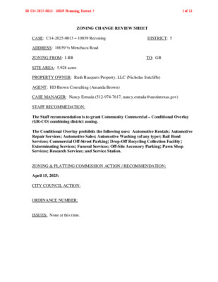
ZONING CHANGE REVIEW SHEET CASE: C14-2025-0013 – 10039 Rezoning DISTRICT: 5 ADDRESS: 10039 ½ Menchaca Road ZONING FROM: I-RR TO: GR SITE AREA: 5.928 acres PROPERTY OWNER: Rush Racquets Property, LLC (Nicholas Sutcliffe) AGENT: HD Brown Consulting (Amanda Brown) CASE MANAGER: Nancy Estrada (512-974-7617, nancy.estrada@austintexas.gov) STAFF RECOMMEDATION: The Staff recommendation is to grant Community Commercial – Conditional Overlay (GR-CO) combining district zoning. The Conditional Overlay prohibits the following uses: Automotive Rentals; Automotive Repair Services; Automotive Sales; Automotive Washing (of any type); Bail Bond Services; Commercial Off-Street Parking; Drop-Off Recycling Collection Facility; Exterminating Services; Funeral Services; Off-Site Accessory Parking; Pawn Shop Services; Research Services; and Service Station. ZONING & PLATTING COMMISSION ACTION / RECOMMENDATION: April 15, 2025: CITY COUNCIL ACTION: ORDINANCE NUMBER: ISSUES: None at this time. 08 C14-2025-0013 - 10039 Rezoning; District 51 of 13 C14-2025-0013 Page 2 CASE MANAGER COMMENTS: The subject rezoning area consists of 5.93 acres located on the east side of Menchaca Road, just south of Slaughter Lane. The site is currently an undeveloped tract that has been zoned as Interim-Rural Residence (I-RR) since its annexation into the city limits in July 2007. Adjacent land uses include construction sales and services immediately to the north and convenience storage businesses to the north and east (CS-CO). The Sweetwater Glen residences are located to the south (I-RR); however, undeveloped land separates the subject property from the residences. Further north, at the intersection of Menchaca Road and Slaughter Lane, is a commercial retail center (GR; LI-CO). A significant portion of the southern area of the subject property is located within the floodplain. Please refer to Exhibits A (Zoning Map) and A-1 (Aerial Exhibit). The Applicant is requesting a permanent zoning designation of Community Commercial (GR) district zoning to allow for the development of an outdoor sports and recreation center. Access to the site will be from Menchaca Road. Please refer to Attachment A (Applicant’s Summary Letter). Staff is recommending (GR-CO) combining district zoning with a Conditional Overlay that consists of prohibited uses listed above. The proposed zoning aligns with the intent of the (GR) district as it will provide recreational services that meet neighborhood and community needs. The (GR-CO) designation will allow for a reasonable use of the site while limiting more intensive commercial uses. The applicant is in agreement with the staff recommendation. BASIS OF RECOMMENDATION: 1. The proposed zoning should be consistent with the purpose statement of the district sought. The proposed Community Commercial (GR) district is intended for office and commercial uses serving neighborhood and community needs, including both unified shopping centers and individually developed commercial sites, and typically requiring locations accessible from major traffic ways. The Conditional Overlay (CO) combining district may be applied in combination with any base district. The district is intended to provide flexible and adaptable use or site development regulations by requiring standards tailored to individual properties. 2. The proposed zoning should allow for a reasonable use of the property. Staff is recommending (GR-CO) combining district zoning for the subject property due to its location along Menchaca Road, a major arterial roadway. This zoning is consistent with the surrounding zoning pattern since there is existing (CS) and (GR) district zoning to the north of this property. In addition, establishing permanent zoning for the site will allow the 08 C14-2025-0013 - 10039 Rezoning; District 52 of 13 C14-2025-0013 Page 3 development of new recreational uses to provide additional services to the surrounding community. EXISTING ZONING AND LAND USES: ZONING Site North CS-CO; GR; LI-CO I-RR South East West I-RR CS-CO; Austin ETJ N/A LAND USES Undeveloped Construction sales and services; Convenience storage; Commercial uses Undeveloped; Residences Undeveloped; Convenience storage; Railroad line Menchaca Road; ETJ Release NEIGHBORHOOD PLANNING AREA: N/A WATERSHED: Slaughter Creek – Suburban CAPITOL VIEW CORRIDOR: No SCENIC ROADWAY: No SCHOOLS: Austin Independent School District Kocurek Elementary School Bailey Middle School Akins High School COMMUNITY REGISTRY LIST: Austin Independent School District Bauerle Ranch Owners Association, Inc. Neighborhood Empowerment Foundation South Austin Neighborhood Alliance (SANA) Sierra Club, Austin Regional Group Sweetwater Glen Homeowner's Association TNR BCP – Travis County Natural Resources Austin Lost and Found Pets Friends of Austin Neighborhoods Hollow at Slaughter Creek HOA Onion Creek HOA Save Our Springs Alliance SELTexas AREA CASE HISTORIES: NUMBER C14-2015-0096 – 10035 Menchaca Road REQUEST I-RR to CS C14-2008-0147 – 10037 Menchaca Road I-RR to CS COMMISSION To Grant CS-CO w/ CO for 2,000 vehicle trip limit/day and a list of prohibited uses (8/18/2015) To Grant CS-CO w/ CO for 2,000 vehicle trip limit/day and a list of prohibited uses (8/19/2008) CITY COUNCIL Apvd CS-CO as Commission recommended (9/10/2015) Apvd CS-CO as Commission recommended (9/25/2008) 08 C14-2025-0013 - 10039 Rezoning; District 53 of 13 C14-2025-0013 RELATED CASES: Page 4 C7a-07-005 – Sweetwater Glen Annexation Area annexed into the City of Austin on July 2, 2007 (Ordinance No. 20070621-025). ADDITIONAL STAFF COMMENTS: Comprehensive Planning Project Name and Proposed Use: 10039-1/2 MENCHACA ROAD. C14-2025-0013. Project: 10039 Rezoning. 5.9280 acres from I-RR to GR. Existing: undeveloped. Proposed: outdoor sports and recreation. Imagine Austin Decision Guidelines Yes Complete Community Measures * Y Imagine Austin Growth Concept Map: Located within or adjacent to an Imagine Austin Activity Center, Imagine Austin Activity Corridor, or Imagine Austin Job Center as identified the Growth Concept Map. Names of Activity Centers/Activity Corridors/Job Centers *: • Within Slaughter Lane Station Neighborhood Center; 0.28 miles from slaughter Lane Activity Corridor Mobility and Public Transit *: Located within 0.25 miles of public transit stop and/or light rail station. Mobility and Bike/Ped Access *: Adjoins a public sidewalk, shared path, and/or bike lane. Connectivity, Good and Services, Employment *: Provides or is located within 0.50 miles to goods and services, and/or employment center. Y • Goods and Services present along Menchaca Rd, and at the intersection of Menchaca Rd and W Slaughter Ln Y Connectivity and Food Access *: Provides or is located within 0.50 miles of a grocery store/farmers market. • 0.5 miles from an HEB grocery store Connectivity and Education *: Located within 0.50 miles from a public school or university. Connectivity and Healthy Living *: Provides or is located within 0.50 miles from a recreation area, park or walking trail. Connectivity and Health *: Provides or is located within 0.50 miles of health facility (ex: hospital, urgent care, doctor’s office, drugstore clinic, and/or specialized outpatient care.) • Within 0.25 miles of an Austin Regional Clinic location Y Housing Choice *: Expands the number of units and housing choice that suits a variety of household sizes, incomes, and lifestyle needs of a diverse population (ex: apartments, triplex, granny flat, live/work units, cottage homes, and townhomes) in support of Imagine Austin and the Strategic Housing Blueprint. Housing Affordability *: Provides a minimum of 10% of units for workforce housing (80% MFI or less) and/or fee in lieu for affordable housing. Mixed use *: Provides a mix of residential and non-industrial uses. Culture and Creative Economy *: Provides or is located within 0.50 miles of a cultural resource (ex: library, theater, museum, cultural center). Culture and Historic Preservation: Preserves or enhances a historically and/or culturally significant site. Creative Economy: Expands Austin’s creative economy (ex: live music venue, art studio, film, digital, theater.) Workforce Development, the Economy and Education: Expands the economic base by creating permanent jobs, especially in industries that are currently not represented in a particular area or that promotes a new technology, and/or promotes educational opportunities and workforce development training. Industrial Land: Preserves or enhances industrial land. Not located over Edwards Aquifer Contributing Zone or Edwards Aquifer Recharge Zone Number of “Yes’s” Y 5 08 C14-2025-0013 - 10039 Rezoning; District 54 of 13 C14-2025-0013 Drainage Page 5 The developer is required to submit a pre- and post-development drainage analysis at the subdivision and site plan stage of the development process. The City’s Land Development Code and Drainage Criteria Manual require that the Applicant demonstrate through engineering analysis that the proposed development will have no identifiable adverse impact on surrounding properties. Environmental The site is not located over the Edwards Aquifer Recharge Zone. The site is in the Slaughter Creek Watershed of the Colorado River Basin, which is classified as a Suburban Watershed by Chapter 25-8 of the City's Land Development Code. The site is in the Desired Development Zone. Under current watershed regulations, development or redevelopment on this site will be subject to the following impervious cover limits: Development Classification % of Gross Site Area % of Gross Site Area Single-Family (minimum lot size 5750 sq. ft.) Other Single-Family or Duplex Multifamily Commercial 50% 55% 60% 80% with Transfers 60% 60% 70% 90% According to floodplain maps there is a floodplain within or adjacent to the project location. Based upon the location of the floodplain, offsite drainage should be calculated to determine whether a Critical Water Quality Zone exists within the project location. Standard landscaping and tree protection will be required in accordance with LDC 25-2 and 25-8 for all development and/or redevelopment. At this time, site specific information is unavailable regarding vegetation, areas of steep slope, or other environmental features such as bluffs, springs, canyon rimrock, caves, sinkholes, and wetlands. Under current watershed regulations, development or redevelopment requires water quality control with increased capture volume and control of the 2 year storm on site. At this time, no information has been provided as to whether this property has any preexisting approvals that preempt current water quality or Code requirements. 08 C14-2025-0013 - 10039 Rezoning; District 55 of 13 C14-2025-0013 Page 6 PARD – Planning & Design Review Parkland dedication fees may apply to any future site or subdivision applications resulting from this rezoning. As of January 1, 2024, new commercial non-residential uses are not subject to parkland dedication requirements at the time of site plan and subdivision. However, PARD would be interested in meeting with the applicant to discuss a potential trail easement along Slaughter Creek. Please reach out to this reviewer to discuss: ann.desanctis@austintexas.gov Site Plan Site plans will be required for any new development except for residential only projects with up to 4 units. Any new development is subject to LDC Subchapter E Design Standards and Mixed Use. Additional comments will be made when the site plan is submitted. Austin Transportation Department – Engineering Review The Austin Strategic Mobility Plan (ASMP) calls for 116 feet of right-of-way for Menchaca Rd. It is recommended that 58 feet of right-of-way from the existing centerline should be dedicated for Menchaca Rd according to the Transportation Plan with the first subdivision or site plan application. [LDC 25-6-51 and 25-6-55]. The adjacent street characteristics table is provided below: Existing ROW Existing Pavement Sidewalks Bicycle Route Approx 116 feet Approx 90 feet No Yes Capital Metro (within ¼ mile) No Name ASMP Classification Menchaca Road (TXDOT Roadway) Level 3 – Major Arterial ASMP Required ROW 116 feet A Traffic Impact Analysis is not required. Austin Water Utility No comments on zoning change. FYI: The landowner intends to serve the site with existing City of Austin water utilities. Depending on the development plans submitted, water and or wastewater service extension requests may be required. All water and wastewater construction must be inspected by the 08 C14-2025-0013 - 10039 Rezoning; District 56 of 13 C14-2025-0013 Page 7 City of Austin. For more information pertaining to the Service Extension Request process and submittal requirements contact the Austin Water SER team at ser@austintexas.gov. INDEX OF EXHIBITS AND ATTACHMENTS TO FOLLOW: Exhibit A: Zoning Map Exhibit A-1: Aerial Map Attachment A: Applicant’s Summary Letter Correspondence 08 C14-2025-0013 - 10039 Rezoning; District 57 of 13 ! ! ( C14-2012-0162 ! ! ! ! ! ! ! ( ( ! ! ! !! ! ! ( ( ! ! ! ! ! ! SP90-80A ! ! ! ( ! ( ! ! ! ! MH ( ! ! ( C14-97-0120 NO ! ! ! ! ! ! ! ! ! C14-2008-0114 C14-2011-0136 C14-2017-0146 ! ! ! LR-MU-CO ( C14-2022-0020 C14-2009-0149 C14-2014-0087 SF-2 ( ( ! ! ! ! ! ! ! ! ! ! ALLRED D R C14-02-0061 C14-2011-0168 GO-MU-CO ( BAR M H SF-2 ( UNDEV BANK GR SP07-0030C SP94-178C GR-CO 92-0114 STATION SP-98-0356C SP96-0210C Y A W E IV R D 01-0115 SP96-0086C SP-05-0823C CS-CO C14-2013-0063 UNDEV MF-1 C14-2020-0131 N L I H S I ( ( I-RR OAK VALLEY RD ( ! ! ! ! ! ! ! I-RR !! ! ! ! ! ! ! ! ( ( ( SCREEN\PRINTING ( ( ( ( ( ( PARKING GR R85-056 SP-01-0451D UNDEV AUTO RENTAL AUTO PARTS AUTO REPAIR RETAIL ( ! ! ! D A R C A H C N E M C14-2012-0074 RETAIL CENTER LI-CO C14-2010-0190 2010-0190 CS-1 R86-023 UNDEV C14-2015-0096 CS-CO 2008-0147 C14-2008-0147 WHSE CONVENIENCE STORAGE ! ! ! ! ! ! ! ! ! ! ! !! ! ! ! ! ! ! ! ! ! ! ! ! ! ! ! ! ! ! ! ! ! ! ! ! ! ! ! RED WATER D R I-RR K E M A H D R R NA D OZO I-RR CONDOMINIUMS ! ! ! I-RR ! ! ! ! ! ! ! !! ! ! ! ! ! ! ! R R P U R O D D E R A L CONSTRUCTION SALES & SVRC I-RR SP-02-0361D AUTO REPAIR CONSTRUCTION\SALES $ SVRC WHSE I-RR SP-05-1249D I-RR TOWNHOUSES I-RR R O C KLA N D D R COMFORT LN I-RR I-RR C 7 A - 0 2 - 0 2 1 I-RR C14-06-0122 MF-2-CO MF-3-CO C14-2007-0254 APARTMENTS YOAKUM ST I-RR R D E L L E D Y A M R D A T T E I R A M R D A F R A M I-RR R D E I L Y W KENDALIA ST I-RR CS-CO 94-0129 E G A R O T S E C N E I N E V N O C ZA I N LN GE N OA D R UNDEV SF-4A C14-2011-0007 H T A P L O O P G N I D A W Y T N U O C R D K E E R C R E T H G U A L S MEADOWSOUTH LN SF-4A UNDEVELOPED SF-4A C14-2011-0008 CEDAR STAND PASS SF-4A CANOPY CREEK WAY SF-4A C14-2011-0008 COUNTY I-SF-4A DIGGY DR I-SF-4A ± SUBJECT TRACT ! ! ! ! ! ! PENDING CASE ZONING BOUNDARY ZONING ZONING CASE#: C14-2025-0013 EXHIBIT A This product is for informational purposes and may not have been prepared for or be suitable for legal, engineering, or surveying purposes. It does not represent an on-the-ground survey and represents only the approximate relative location of property boundaries. 1 " = 400 ' This product has been produced by the Planning Department for the sole purpose of geographic reference. No warranty is made by the City of Austin regarding specific accuracy or completeness. Created: 1/24/2025 08 C14-2025-0013 - 10039 Rezoning; District 58 of 13 EXHIBIT A-1 08 C14-2025-0013 - 10039 Rezoning; District 59 of 13 ATTACHMENT A Via Electronic Submittal Lauren Middleton-Pratt City of Austin Planning and Housing Department 1000 E 11th St. Austin, TX 78702 Re: Rezoning request for 10039 1/2 Menchaca Rd; TCAD Parcel 997166 (the “Property”) Dear Mrs. Middleton-Pratt: As representatives of the owner of the above stated Property, we respectfully submit an application for rezoning. The Property is located at 10039 1/2 Menchaca Road and is currently undeveloped. We are requesting to rezone the Property from Interim-Rural-Residential to General Retail (GR). The purpose of the rezoning is to allow for the development of an outdoor sports and recreation center. The Property is not within a neighborhood plan, therefore a Future Land Use Map amendment is not required. The surrounding zoning is unzoned to the east and west, as they are in the ETJ. The properties to the north are zoned CS-CO and I-RR with an industrial and self-storage use. To the south, properties are zoned I- RR with a large buffer zone between the property and SF residential properties to the south. If you have any questions regarding this request or need additional information, please do not hesitate to contact me at your convenience. Very truly yours, Amanda Couch Brown 214-695-9219 | AMANDA.BROWN@HDBROWNCONSULTING.COM | HDBROWNCONSULTING.COM08 C14-2025-0013 - 10039 Rezoning; District 510 of 13 08 C14-2025-0013 - 10039 Rezoning; District 511 of 13 March 04, 2025 Marcelle Boudreaux Case Manager City of Austin Housing & Planning Department Marcelle.Boudreaux@austintexas.gov RE: Letter of Support for Zoning Request at 10039 1/2 Menchaca Road (Case No. C14- 2025-0013) Dear Councilmembers and Commissioners: As a nearby stakeholder, please accept this letter as my support as a nearby for the above referenced zoning case. Thank you, [Signature] [Name] W. Tylere Brennan [Address] 10308 Menchaca Rd Austin, TX 78748 08 C14-2025-0013 - 10039 Rezoning; District 512 of 13 08 C14-2025-0013 - 10039 Rezoning; District 513 of 13