04 SPC-2023-0033C - Project Connect Expo Center Park & Ride; District 1.pdf — original pdf
Backup
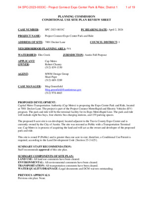
PLANNING COMMISSION CONDITIONAL USE SITE PLAN REVIEW SHEET CASE NUMBER: SPC-2023-0033C PC HEARING DATE: April 2, 2024 PROJECT NAME: Project Connect Expo Center Park and Ride ADDRESS OF SITE: 7001 Decker Lane COUNCIL DISTRICT: 1 NEIGHBORHOOD PLANNING AREA: NA WATERSHED: Elm Creek JURISDICTION: Austin Full Purpose APPLICANT/ OWNER: AGENT: Cap Metro Robert Chaney (512) 839-1330 MWM Design Group Shari Pape (512) 689-3289 CASE MANAGER: Meg Greenfield Meg.greenfield@austintexas.gov (512) 978-4663 PROPOSED DEVELOPMENT: Capital Metro Transportation Authority (Cap Metro) is proposing the Expo Center Park and Ride, located at 7001 Decker Lane. The project is part of the Project Connect MetroRapid and Electric Vehicles (EV) program. The park and ride will be the terminal facility for its Expo MetroRapid Line. The park and ride will include eight bus bays, four electric bus charging stations, and 159 parking spaces. The proposed 8-acre site is un-developed, located adjacent to the Travis County Expo Center and is currently owned by the City of Austin. The site was rezoned as Public with a Transportation Terminal use. Cap Metro is in process of acquiring the land and will act as the owner and developer of the proposed park and ride. This site is zoned P (Public) and is greater than one acre in size; therefore, a Conditional Use Permit is required, according to the Land Development Code {Section 25-2-625}. SUMMARY STAFF RECOMMENDATION: Staff recommends approval of this site plan. SUMMARY COMPONENTS OF SITE PLAN: LAND USE: All land use comments have been cleared. ENVIRONMENTAL: All environmental comments have been cleared. TRANSPORTATION: All transportation comments have been cleared. WATER QUALITY/DRAINAGE: Legal documents and DCM waivers outstanding. PREVIOUS APPROVALS Previous site plan: None. 1 of 1904 SPC-2023-0033C - Project Connect Expo Center Park & Ride; District 1 PROJECT INFORMATION SITE AREA EXISTING ZONING FLOOR-AREA RATIO BUILDING COVERAGE BUILDING HEIGHT IMPERVIOUS COVERAGE PARKING EXISTING ZONING AND LAND USES 347,971 sq. ft. P Allowed NA NA NA NA NA 7.988 acres Proposed NA .12% 12 ft 64% 159 spaces ZONING LAND USES Vacant Parking Vacant Parking Multifamily P SF3 CS-CO SF3 MF2 Site North South East West ABUTTING STREETS Street Decker Lane Right-of-Way Width 125 feet (variable) Approx. 75 feet Pavement Width Classification Suburban Roadway NEIGHBORHOOD ORGANIZATIONS: Austin Independent School District Austin Lost and Found Pets Austin Neighborhoods Council City of Manor, Colony Park/Lakeside Community Development Corp Del Valle Community Coalition Del Valle Independent School District Friends of Austin Neighborhoods Friends of Northeast Austin Homeless Neighborhood Association Imperial Neighborhood Association Neighborhood Empowerment Foundation Neighbors United for Progress Parker Station Residential Community SELTexas Sierra Club Austin RegionalGroup 2 of 1904 SPC-2023-0033C - Project Connect Expo Center Park & Ride; District 1 Engineering Report 1/11//2022 EXHIBIT 1 Site Location Map 12 3 of 1904 SPC-2023-0033C - Project Connect Expo Center Park & Ride; District 1 Project Connect Expo Center Park and Ride Engineer’s Summary Letter Site Development Permit This letter is a summary of findings related to the proposed construction of Capital Metro Transportation Authority’s (Capital Metro) Expo Center Park and Ride, located at 7001 Decker Lane. The project is part of Project Connect and it’s MetroRapid and Electric Vehicles (EV) program. The park and ride will be the terminal facility for its Expo MetroRapid Line. The park and ride location, which includes eight bus bays including four electric bus charging stations of EV on site, is adjacent to the Travis County Exposition Center (Expo Center) near the intersection of Decker Lane and Carnival Drive in eastern Austin. The park and ride facility is currently being designed to accommodate 150 vehicles. The proposed improvements include: • Eight bus bays with four (4) battery electric bus charging stations of EV; • Approximately 150 parking spaces for commuter use; • Electrical transformer and additional electrical equipment for electric bus charging infrastructure; • Bus shelter and other amenities within the bus platform areas; • Prefabricated restroom facility for use by bus drivers; • Water quality pond for on-site detention; • Sidewalks throughout the site for safe pedestrian passage; • Retaining walls and other features to mitigate existing site slopes and maintain trees The proposed 8.01 acre site is un-developed, located adjacent to the Travis County Expo Center and is currently owned by the City of Austin. The site was rezoned as Public-Transportation. Capital Metro will act as the owner and developer of the proposed park and ride. The site is located within the Elm Creek watershed, and is not located within the 25-year or 100-year floodplain per the Federal Emergency Management Agency (FEMA) Flood Insurance Rate Map (FIRM) Map No. 48453C0490K, dated 1/22/2020. Stormwater runoff from the site currently discharges to Carnival Drive and on to Decker Ln. For the proposed development, stormwater runoff will be collected curb inlets and conveyed via storm sewer to a proposed on-site water quality/detention pond. The proposed water quality/detention pond will mitigate the additional stormwater runoff from the additional impervious cover to the existing conditions of the discharge point. 1 4 of 1904 SPC-2023-0033C - Project Connect Expo Center Park & Ride; District 1 A variance to Land Development Code 25-8-341&342 and 25-8-301&302 is anticipated for this project, due to the cut and fill heights exceeding 4 feet. The existing topography slopes from a from the northeast portion of the site down to the southwest portion of the site. To meet ADA requirements and meet parking requirements, required the use of retaining walls with cut and fill areas exceeding 4 feet. In addition, there are existing slopes that exceed 15%. The slopes that will remain that exceed 15% were maintained to minimize impact to existing trees. Brent R. Kyler Brent R. Kyler Senior Project Manager HNTB Corporation 2 5 of 1904 SPC-2023-0033C - Project Connect Expo Center Park & Ride; District 1 CITY OF AUSTIN – DEVELOPMENT SERVICES DEPARTMENT SITE PLAN APPLICATION – MASTER COMMENT REPORT CASE NUMBER: REVISION #: CASE MANAGER: Meg Greenfield SPC-2023-0033C 00 UPDATE: PHONE #: U3 PROJECT NAME: LOCATION: Project Connect Expo Center Park and Ride 7001 DECKER LN SUBMITTAL DATE: REPORT DUE DATE: FINAL REPORT DATE: February 9, 2024 February 26, 2024 March 6, 2024 9 DAYS HAVE BEEN ADDED TO THE UPDATE DEADLINE STAFF REPORT: This report includes all staff comments received to date concerning your most recent site plan submittal. The comments may include requirements, recommendations, or information. The requirements in this report must be addressed by an updated site plan submittal. The site plan will be approved when all requirements from each review discipline have been addressed. However, until this happens, your site plan is considered disapproved. Additional comments may be generated as a result of information or design changes provided in your update. If you have any questions, problems, concerns, or if you require additional information about this report, please do not hesitate to contact your case manager at the phone number listed above or by writing to the City of Austin, Development Services Department, P.O. Box 1088, Austin, Texas 78767. CONFLICT RESOLUTION PROCESS PILOT: We are piloting a new Conflict Resolution Process. Please complete this form if you have identified two or more comments in your Master Comment Report that are in conflict, meaning that you do not believe that both comments can be satisfied. Conflicts can only be submitted and resolved between review cycles; they cannot be submitted while the site plan is in review. UPDATE DEADLINE (LDC 25-5-113): It is the responsibility of the applicant or their agent to update this site plan application. The final update to clear all comments must be submitted by the update deadline, which is April 21, 2027. Otherwise, the application will automatically be denied. If this date falls on a weekend or City of Austin holiday, the next City of Austin workday will be the deadline. UPDATE SUBMITTALS: A formal update submittal is required. Please bring a copy of this report with you upon submittal to Intake. Updates may be submitted between the hours of 8:30 am and 4:00 pm. Updates submitted after 3 pm may be processed on the following business day. REVIEWERS: Planner 1 : Mase Cone Addressing : Janny Phung Drainage Engineering : Jose Castillo Site Plan Plumbing : Cory Harmon Water Quality : Jose Castillo AW Pipeline Engineering : Jaron Hogenson Environmental : Talula Thibault Site Plan : Meg Greenfield AW Utility Development Services : Bradley Barron 1 6 of 1904 SPC-2023-0033C - Project Connect Expo Center Park & Ride; District 1 Electric Review - Andrea Katz - 512-322-6957 Comments clear. Be advised, however that the electric facilities shown on this site plan are considered conceptual. The layout shown should not be used for bidding and the final electric design as done by Austin Energy may vary from that shown. Changes to the site plan may be required. Keep in mind the designer may require and/or request additional information to be able to complete the design and the proposed facility locations may be subject to change based on design. FYI: Austin Energy must review any changes to this plan that may affect electric requirements. These changes include, but are not limited to, changes in building square footage, building location, detention facilities' location, grading, spoil site locations, etc. Addressing Review - Janny Phung - janny.phung@austintexas.gov AD1: Addressing rejects this Site Plan for the following reason: AD2: Comments Cleared AD3: Comment Pending The street name CARNIVAL DR should be removed from all sheets since this is not a recognized road name in the county for emergency response. Street names need to named on recorded plats on private property to receive separate addresses on the named roadway. CARNIVAL DR appears on sheet 130 of 142. AD4: Comment Pending Situs/physical for Travis County Appraisal District is inaccurate. It is currently listed as 8003 DECKER LN and should be updated to 7311 DECKER LN. This property will have multiple addresses assigned. You may send an Address Verification Letter to Travis County Appraisal District to update at CSInfo@tcadcentral.org. End of Comments 2 7 of 1904 SPC-2023-0033C - Project Connect Expo Center Park & Ride; District 1 Drainage Engineering Review - Jose Castillo - 512-974-7273 Release of this application does not constitute a verification of all data, information, and calculations supplied by the applicant. The engineer of record is solely responsible for the completeness, accuracy, and adequacy of his/her submittal, whether or not the application is reviewed for code compliance by city engineers. DE 3. Clearly show and label all existing and proposed drainage easements on drainage layout sheet as per final plat or by separate instrument. [Application packet] U1. Comment stands. The drainage easements cannot be found in the drainage area maps. U2. Comment remains. Drainage Easement found in sheet 57. Add DE recording number as soon as it is available. U3. Comment remains. Provide documents when available. The metes and bounds needs to be revised by this reviewer then the legal department and then recordation of document. Submit the metes and bounds and legal documents when available. DE 5. Please provide both existing and proposed drainage area maps with common points of analysis. Please make sure that the drainage area maps show all onsite drainage basins and are separated from offsite drainage basins. DCM 1.2.2.D. U1: Comment stand. The proposed drainage area map and existing drainage area maps need to be separated in order to see what is existing and what is proposed. The offsite drainage basins should also be shown on both drainage area maps and labeled as offsite or something similar. Please ensure that offsite flows are separate from onsite flows. The onsite drainage basins should add up and be same for existing and proposed conditions and match with the overall site size. U2. Sheet #70, Existing Onsite and Offsite Drainage Map Sheet #71, Proposed Onsite and Offsite Drainage Map If a problem with these basic changes, provide one existing On-Site Map, one existing Off-site Map, one proposed On-site Map and one proposed Off-site map. Comment remains. Make the following modifications in the sheet titles: Are you detaining for the proposed road? Are you over detaining on the proposed detention pond for this proposed road that is downstream of it? U3. Comment clears. DE 6. Please provide a summary table comparing the existing conditions to the proposed conditions. Comment stands. Please include IC% for the offsite flows. The IC % for existing and Include information used to determine the peak flows for all drainage areas such as the drainage area designations, sizes, amounts of impervious cover, time of concentrations, intensity, runoff coefficients, curve numbers, and peak flows for the 2-, 10-, 25-, and 100-year storm events at the points of analysis. U1: proposed are shown as the same. Please clarify. Comment remains. Please see DE 5. For design of drainage easements (off-site U2. drainage), these areas will be considered as fully developed per DCM 8.3.3 and LDC 25-7-151 B, please reflect that information in maps. Add any additional notes in Drainage Maps, eg. off-site drainage existing with existing CN and proposed off-site drainage with fully developed CN and a note saying that these flows were used for the design of the drainage easement. U3. Comment clears. DE 10. Please ensure that offsite flows are separated from onsite flows. Fully developed conditions should be used for calculating flows for the offsite areas. Drainage easements are required for conveyance of offsite flows through the site. [LDC 25-7-151 & 25-7-152]. U1. Comment stands. The drainage area map still shows onsite flows with offsite flows (part of the road seems to be included with the onsite flows). This comment will remain open until the recordation of the drainage easement. 3 8 of 1904 SPC-2023-0033C - Project Connect Expo Center Park & Ride; District 1 Comment remains. This comment will remain open until the recordation of the drainage U2. easement. U3. Comment remains open until DE is recorded. DE 11. Please show compliance with DCM 1.2.3.C. Comment remains. Add the requested information in the construction plans and provide a Please provide more information about the existing ditch. Provide calculations showing U1. that the existing ditch does have capacity for the flows. Please provide compliance with DCM 6.4.1. Velocity flows will need to be less than 6fps and the flows will need to come at an angle in order to prevent any erosion. U2. sheet number for this information. Also, provide plan and profile sheets for channels 1, 2, 3 4, 5 and 6 which will be part of the proposed drainage easement. Please keep in mind that is some infrastructure not permitted inside drainage easements (such as retaining walls, or other similar improvement in the easement tract, please contact Legal Department if you have any questions about this topic, appears to have proposed curb and gutter and parking in some locations.) U3. Comment clears DE 17. Please verify how close the retaining walls are to the ROW. If they are in close, proximity the ROW, this plan will need to be reviewed by Quality Management Division (QMD) of Public Works. Please email the standard submittal form and PDFs of the plan set to QMD@austintexas.gov and copy me. This comment will be cleared once I receive an approval memo from QMD. U1. Comment pending email verification from QMD. U2. U3. Comment remains. Comment pending email verification from QMD. Comment clears. DE 18. Please demonstrate the "draw-down" time for the proposed detention pond will not exceed 24- hours from the time of peak storage to the time of complete emptying of the pond, as determined by hydrograph routing or other calculations acceptable to the City. [DCM 1.2.4(E)(18)] U1. Comment pending DE 13. U2. Comment remains. Provide a printout of hydrograph showing the following information: peak flow occurs at 12:16 and complete emptying occurs at 22:06, providing a draw-down time for detention of less than 24-hours. The information mentioned was not found in submittal package. U3. Comment clears. DE 19. Please provide an updated electronic copy of the model used for hydrologic engineering and planning for the site. U1. Comment pending DE 13. U2. information mentioned was not found in the submittal package. U3. Comment clears. Comment remains. The information mentioned did not get to this reviewer. The DE 20. FYI: Additional comments will be generated once the above comments are addressed. U2. Comment remains. U3. Comment remains. New comments U2. sheets, summary letters and reports. U3. Comment clears. DE 21. Texas Registered Professional Engineer's seal, signature and date must be legible on all plan DE 22. Did you submit already the metes and bound and legal documentation for these drainage easements? If not, please email information to this reviewer. 4 9 of 1904 SPC-2023-0033C - Project Connect Expo Center Park & Ride; District 1 DE 23. Add a Point of Analysis (POA) table comparing existing vs proposed for the 2-, 10-, 25-, 100-year storm event. Please indicate where these table is located in your next update. I understand it is only one Poa for this project (south of Carnival Dr.). U3. Comment clears. U3. Comment remains. Storm Sewer System DE 24. Per DCM 5.2.0.F. Where a lateral conduit intersects the trunk line at a wye junction, the soffit elevation of the incoming lateral conduit shall match the approximate soffit elevation of the trunk line conduit. If the soffit elevations are not proposed to be approximately the same, a request for a waiver will be required. Special consideration may be given in cases where there are design constraints such as the presence of existing major utilities which prevent the matching of soffit elevations without extensive utility relocations. In the case of a lateral pipe intersecting a box culvert, allowances shall be made to allow the wall of the pipe to penetrate the wall of the box without having to notch either the pipe wall or the top slab of the box. Meet code in all instances for proposed storm sewer in the proposed drainage easement. U3. add the title Storm sewer system layout. Comment remains. Change title of sheets 85-89 to Storm Sewer Profiles. For sheet 59, DE 25. Per DCM 5.2.0.G. For all pipe junctions other than a manhole, the angle of intersection between any two flow paths shall not be greater than 45 degrees. This includes discharges into box culverts and channels. Meet code in all instances for proposed storm sewer in the proposed drainage easement. Comment clears. U3. DE 26. Per DCM 5.2.0.L. The 25-year hydraulic grade line shall remain a minimum of six (6) inches below the theoretical gutter flow line of inlets. Meet code in all instances for proposed storm sewer in the proposed drainage easement. U3. Comment clears. DE 27. Per DCM 5.1.0. The design storm shall be the 25-year storm with provisions made for the 100- year storm as noted in Section 3. Meet code in all instances for proposed storm sewer in the proposed drainage easement. U3. Comment clears. DE 28. Per DCM 5.6.1. Spacing in manholes, Due to equipment constraints, every point within the storm drain must be a maximum of 250 feet from an access point for drains 30 inches in diameter or smaller. For storm drains greater than 30 inches in diameter, manholes shall be placed so that there is a maximum distance of 300 feet to an access point. Storm drain outfalls may be considered as access points for maintenance purposes. Meet code in all instances for proposed storm sewer in the proposed drainage easement. U3. Comment clears. DE 29. Per DCM 5.7.0. Depth of cover. The minimum depth of cover shall be two and a half feet (2.5 ft) over the storm drain outer edge except at the connection to a storm drain inlet. Depth of cover is measured from the ground elevation to the top outer edge of the storm drain. Meet code in all instances for proposed storm sewer in the proposed drainage easement. U3. Comment clears. DE 30. At least one element has been identified in the Storm sewer sheets (7’ X 7’ junction box) that will need either request a waiver because COA does not have a standard detail. Per DCM 1.2.4.A. All drainage system components that are within public right-of-way or public drainage easements shall be manufactured and installed in compliance with the City of Austin Standard 5 10 of 1904 SPC-2023-0033C - Project Connect Expo Center Park & Ride; District 1 Specifications and Standards and shall comply with all applicable portions of the City of Austin's Transportation Criteria Manual published by the Department of Transportation, unless: Those components receive stormwater runoff solely from private property, That property consists solely of the property being developed, and 1. 2. 3. Those components are privately maintained. U3. Comment clears. DE 31. Per DCM 5.6.1. Access points must be accessible in accordance with the requirements of Section 1.2.4.E of this Manual and must provide a maintenance path within the storm drain that has no more than one horizontal bend, with that bend having a deflection of no more than forty- five (45) degrees in the direction of the maintenance path, and no vertical bend with a deflection of greater than five (5) degrees. Appears Line B1 has two bends. U3. Comment clears. DE 32. DCM 1.2.4.A. Provide a COA construction detail for the curb inlet instead of proposed TxDot detail. U3. Comment clears. system. U3. DE 33. Provide storm sewer models for all the proposed storm that is located in proposed storm sewer Comment remains. Model received and sent to WPD for review. DE 34. To request a DCM waiver, please provide a letter (typically 1-2 pages of text plus exhibits) either addressed to your DSD Drainage Reviewer or Watershed Protection Department, the document should include the following information: 1) the Address of the site, project name, and permit number, 2) the section of DCM for the waiver(s), 3) along with EXHIBITS that show the location of the waiver request, corresponding plan, profile, and detail sheets (for any non-standard infrastructure), as appropriate. Please circle in red or highlight the waiver portion of the plans; for waivers related to storm drains and SD easements include plan and profiles. The letter should include: 4) explain why the DCM cannot be met, 5) why the proposed solution is the only feasible option in this scenario, 6) and provide justification for the waiver request, which may require calculations to prove no other property or ROW will be adversely affected by the wavier. DCM waivers require substantial review since they are requests for non-compliance, therefore they can add significant review time. To reduce review time please review the justification with your DSD Drainage Reviewer if you have one or Project Sponsor before submitting it to WPD. All waivers are reviewed by Watershed Protection Department. U3. Comment remains. This comment will remain open until all DE comments are cleared. Environmental Review - Talula Thibault - talula.thibault@austintexas.gov Update 3February 22, 2023 EV 01-03 Comments previously cleared. 6 11 of 1904 SPC-2023-0033C - Project Connect Expo Center Park & Ride; District 1 EV 04 U3 Comment cleared. EV 05 Provide the current ECM Appendix P-1: Erosion Control Notes. The notes can be found at: https://www.municode.com/library/tx/austin/codes/environmental_criteria_manual?nodeId=APXP- 1ERCONO. The P-1 notes are missing information. Add the Developer Information to the ECM Appendix P-1 Erosion Control Notes (note #10). U3 Comment pending. Add missing Developer Info to the ECM P-1 ESC Notes (#10) on sheet 138 of the plan set. EV 06-08 Comments previously cleared. EV 09 Provide a grading exhibit with clear, differentiating hatches or colors for the following categories: • Cut -4.00 to -8.00 feet; • Cut greater than -8.00 feet; • Fill 4.00 to 8.00 feet; • Fill greater than 8.00 feet; • Slopes over 15%; • Proposed pond footprint(s); and • Public streets. Exclude grading beneath buildings, parking garages, and public ROWs. Additional grading review and comment may be pending. [LDC 25-8-341 & 342] U3 Environmental Variance has been granted to allow cut and fill measurements that exceed four (4) feet, per LDC 25-8-341 & 342.” Comment pending. Add a note to the plan set cover sheet stating: “An Administrative Comments previously cleared. EV 10-12 EV 13 U3 Comment cleared. EV 14-28 Comments previously cleared. Site Plan Review - Meg Greenfield - meg.greenfield@austintexas.gov Reviewer notes: Compatibility is triggered by the adjacent SF3 site to the northeast; however this project is exempt per 25-10-1052B-4-a. This project is exempt from Subchapter E per Ord. 20220519-094. ZONING SP1. Please label zoning and land use of subject and adjacent sites. Show all existing buildings on adjoining lots within 50 feet. If no buildings exist within 50 feet on adjoining lots, note this on the site plan sheet. U1: Comment cleared. SP2. This site is zoned P (Public) and is greater than one acre in size; therefore, a Conditional Use Permit is required, according to the Land Development Code {Section 25-2-625}. Once all reviewers are clear or informal, contact this reviewer to schedule for ZAP. U1-2: Comment pending. U3: ZAP will be scheduled by this reviewer. SP3. – SP7 comments cleared. 7 12 of 1904 SPC-2023-0033C - Project Connect Expo Center Park & Ride; District 1 SP8. Please add case number (SPC-2023-0033C) to bottom right hand corner of every sheet. U1: Please add to sheet 7 and traffic control sheets. U2: comment not addressed. Also case number and sheet numbers are missing from landscape sheets. Please always check the sheets you get from consultants and make sure the formatting matches and is correct. U3: comment cleared. SP9. – SP14. Comments cleared. Site Plan Plumbing - Cory Harmon - 512-974-2882 1. 2. 3. 4. a. b. Civil Engineer – The water supply fixture unit demand shown on the demand data table on the Austin Water general info sheet is incorrect. Provide a detailed water supply fixture unit analysis broken out by fixture type. The water supply fixture units must be calculated according to the 2021 Uniform Plumbing Code. Ensure that the water supply fixture unit demand is converted to GPM demand in accordance with appendix A of the 2021 Uniform Plumbing Code. The Austin Water general info sheet indicates that the domestic water meter will be 2”; however, the Proposed Water and Wastewater Utilities Plan indicates that it will be 1”. Rectify this discrepancy. Revise the Proposed Water and Wastewater Utilities Plan: The plan indicates that the irrigation backflow preventer will be installed inside of the public easement. The backflow preventer is a private appurtenance and must be installed outside of the public easement. Revise plans accordingly. Relocate the city cleanout such that it is located at the public easement boundary. (fourth request) AW Utility Development Services - Bradley Barron - Bradley.Barron@austintexas.gov AW1. Per Utility Criteria Manual Section 2, §15-9, §25-4, §25-5, §25-9, and the Uniform Plumbing Code: The review comments will be satisfied once Pipeline Engineering has approved the water and wastewater utility plan. For plan review status, contact Jaron Hogenson with Pipeline Engineering at (512)972-0235 or Jaron.Hogenson2@austintexas.gov. Water Quality Review - Jose Castillo - 512-974-7273 Release of this application does not constitute a verification of all data, information, and calculations supplied by the applicant. The engineer of record is solely responsible for the completeness, accuracy, and adequacy of his/her submittal, whether or not the application is reviewed for code compliance by city engineers. WQ 21. Please provide compliance with § 25-1-83 which requires all commercial and multi-family applications for subdivision, site plan, and building permit on tracts greater than one acre or on tracts one acre or less, but within an abandoned landfill buffer as shown on the City of Austin closed landfill map to provide a: 1. City of Austin Certification of Compliance Form; 2. Certificate sealed by a Professional Engineer certifying the site is not over a closed landfill and describing the basis for that determination, or; 3. Development permit from the TCEQ, or; 8 13 of 1904 SPC-2023-0033C - Project Connect Expo Center Park & Ride; District 1 4. Letter from TCEQ stating that the project is not subject to the requirements of TAC Ch. 330, Subchapter T. The applicant may find the Landfill Certification Form on the City of Austin website at http://www.ci.austin.tx.us/watershed/downloads/engineers_cert_form.pdf. The exhibit does not provide the form. Comment stands. U1. Comment remains. U2. Comment clears. U3. WQ 23. Projects submitted after November 7, 2022, will be required to provide green stormwater control measures to meet water quality control requirements (with some exceptions) in accordance with the recently passed Ordinance No. 20221027-045, Part 18 [25-8-213 (C) and (D)]. Green infrastructure options are outlined in ECM 1.6.7. Administrative waivers may be granted on a case-by-case basis. The ordinance document can be found here (see pg. 24-26 for green infrastructure requirements):https://services.austintexas.gov/edims/document.cfm?id=399108. U1. U2. add the title Appendix R-6- Full or Partial Biofiltration Pond Calculations for Development Permits and make sure this table matches with ECM. U3. Comment clears. The water quality pond is not a green pond. Please comply. Comment remains. We acknowledge that a biofiltration pond is proposed. On sheet 61, WQ 26 Please show compliance with DCM 1.2.4.E. Comment remains. This detention/water quality pond has to meet all items for the COA U1. Comment pending DE 13. U2. maintained pond per table in DCM 1.2.4 Drainage System. Clearly mark all the items in sheet 59 of 142. Some items not found in plans are the 12-foot access strip around basin and staging area. Other items not found in this sheet and mentioned included: drainage easements, setbacks, fencing, gates, outfalls, signage, and landscaping. Is this detention/WQ pond in an drainage easement? U3. Comment clears. WQ 27 Include riprap detail and rip rap calculations per ECM 1.4.6.D. Comment remains. Please indicate the location for rip rap detail, the rip-rap calculation is WQ 29 FYI: Additional comments will be generated once the above comments are addressed. U1. Comment pending DE 13. U2. located in sheet 61. U3. Comment clears. U2. U3. Comment remains. Comment remains. New Comments for U3 Biofiltration (Partial) compliance. IPM PLANS WQ30. The basin separator element in a partial sedimentation/biofiltration pond should comply with the specifications found in ECM 1.6.7.C(3)(B). WQ31. Provide the detail found in ECM Figure 1.6.7.C-2 for the basin separator element. Ensure WQ31. An Integrated Pest Management (IPM) plan is required for this project per ECM 1.6.2(F). Please submit an IPM plan, in accordance with the requirements outlined in ECM 1.6.9(2) (D)(2). The 9 14 of 1904 SPC-2023-0033C - Project Connect Expo Center Park & Ride; District 1 City of Austin has an online process https://www.austintexas.gov/department/integrated-pest-management. for IPM submittals. Please submit online at WQ32. Once the IPM has been submitted online and approved, an IPM restrictive covenant should be recorded to tie the document to the property per ECM 1.6.2.F. The standard document is available online at http://www.austintexas.gov/page/common-easement-and-restrictive- covenants#pdrd. This comment will clear once the IPM RC is recorded, and the document number is provided on the cover sheet of the plans. WQ33. Please place the following note on the cover sheet: “For Integrated Pest Management Plan, see agreement filed in document No. ________________, Official Public Records, Travis County, Texas.” AW Pipeline Engineering - Jaron Hogenson - (512) 972-0235 AWPE Redlines can be found here: https://studio.bluebeam.com/share/okwvzv Planner 1 Review – Mase Cone – mase.cone@austintexas.gov 1. End of Master Comment Report Fill out the Site Plan Approval blocks with the following information in bold. Sheet numbering File number: SPC-2023-0033C Application date Under Section 112 (or 142) of Chapter 25-5 of the City of Austin Code Case Manager: Meg Greenfield Zoning 10 15 of 1904 SPC-2023-0033C - Project Connect Expo Center Park & Ride; District 1 N G I S E D % 0 3 M I R E T N I T N E M U C O D T C A R T N O C PROPOSED FENCE CONNECTION TO EXISTING FENCE L6 PROPERTY LINE CHANNELIZING MEDIAN R=15' R=15' ' 5 2 ' 5 2 S E C A P S 0 2 25' ' 5 2 10' SDWK 19' K W D S ' 8 N L R E K C E D ) W O R ' 0 2 1 ( 7 L EXISTING TREE TO REMAIN SEE TREE MITIGATION PLANS SCALE IN (FEET) 0 20 40 80 TRAVIS COUNTY EXPOSITION CENTER SITE TABLE NOTES: TOTAL SITE AREA FLOOR TO AREA RATIO 347,971 SF 0.00121:1 IMPERVIOUS COVER (SF/%) 223,781 SF/64.31% BUILDING COVERAGE (SF/%) 420 SF/0.12% 1. SEE PHASING PLANS FOR LIMITS OF CONSTRUCTION. 2. 7 U-RACKS/14 BICYCLE PARKING SPACES WILL BE PROVIDED. 3. SEE PLAT, EASEMENTS, AND ZONING SHEET FOR MORE INFORMATION. PROPOSED USE TRANSPORTATION TERMINAL BUILDING TABLE TOTAL BUILDING AREA (SF) NUMBER OF STORIES ACTUAL HEIGHT (FT) 342 SF 1 FT12 4. ALL IMPROVEMENTS SHALL BE MADE IN ACCORDANCE WITH THE RELEASED SITE PLAN. ANY ADDITIONAL IMPROVEMENTS WILL REQUIRE SITE PLAN AMENDMENT AND APPROVAL OF THE DEVELOPMENT SERVICES DEPARTMENT. 5. APPROVAL OF THIS SITE PLAN DOES NOT INCLUDE BUILDING AND FIRE CODE APPROVAL NOR BUILDING PERMIT APPROVAL. PARKING SCHEDULE 6. ALL SIGNS MUST COMPLY WITH REQUIREMENTS OF THE LAND DEVELOPMENT CODE (CHAPTER 25-10). USE TYPE: TRANSPORTATION TERMINAL 7. ADDITIONAL ELECTRIC EASEMENTS MAY BE REQUIRED AT A LATER DATE. SQUARE FOOTAGE: SEE NOTE 3 WATER AND WASTEWATER SERVICE WILL BE PROVIDED BY THE CITY OF AUSTIN. 8. 9. ALL EXISTING STRUCTURES SHOWN TO BE REMOVED WILL REQUIRE A DEMOLITION PERMIT FROM THE CITY OF AUSTIN DEVELOPMENT SERVICES ADA SPACE 11'-0" X 18'-0" 5 EV CHARGING SPACE 9'-0" X 18'-0" 17 (SEE NOTE 4) 10. A DEVELOPMENT PERMIT MUST BE ISSUED PRIOR TO AN APPLICATION FOR BUILDING PERMIT FOR NON-CONSOLIDATED OR PLANNING COMMISSION APPROVED SITE PLANS. STANDARD SPACE 9'-0" X 18'-0" 138 TOTAL 159 11. FOR DRIVEWAY CONSTRUCTION: THE OWNER IS RESPONSIBLE FOR ALL COSTS FOR RELOCATION OF, OR DAMAGE TO UTILITIES. METES AND BOUNDS 12. FOR CONSTRUCTION WITHIN THE RIGHT-OF-WAY, A ROW EXCAVATION PERMIT IS REQUIRED. L1 N62°41'07.3"W 761.1' 13. NO EXISTING BUIDLINGS ON ADJOINING SITES ARE WITHIN 50 FEET OF L2 S28°24'18.7"W 266.1' THE PROPOSED SITE. L3 S43°38'19.8"E 142.7' AND DETAIL SHEET (SHT 157) 14. UTILIZE SECTION A-A (ALTERNATE) ON PLATFORM FOUNDATION SECTION LEGEND PROPERTY LINE MAINTENANCE STAGING AREA PEDESTRIAN ELEMENTS ROADWAY & PARKING LOT ELEMENTS FENCING EXISTING TREES 3 9 . 5 6 5 . A T S N ° 3 . 0 3 = t a L W ° 6 . 7 9 = n o L C F 19 SPACES 25 SPACES 28 SPACES 32 SPACES ' 5 2 30 SPACES VAN-ACCESIBLE PARKING SPOT PROPOSED BIKE/SCOOTER PARKING 283.4' D CANOPY SETBACK TO DECKER LN ' 8 . 9 1 ' 4 1 E DRIVER RESTROOM/ COMMS. BUILDING L5 PARKING TYPE SIZE COUNT DEPT. RETAINING WALL B PROPERTY LINE EXISTING TREE TO BE REMOVED SEE TREE MITIGATION PLANS L4 RETAINING WALL A PROPOSED WATER & WASTEWATER EASEMENT L3 PROPOSED EV BUS CHARGERS (SEE SHEET 43) B A PROPOSED 75' x 11' CANOPY WITH WHEELCHAIR CHARGING/PARKING (SEE NOTE 14) G H BUS PADS (TYP) SEE COA BUS STOP PAVING STANDARDS R=21.5' BUS LOOP PROPOSED FENCING R=60.5' L4 S45°18'13.3"E 131.5' L5 S22°14'35.5"E 405.1' L6 N61°35'12.7"W 191.5' L7 S27°51'39.1"W 618.4' EXISTING TREE TO REMAIN SEE TREE MITIGATION PLANS EXISTING TREE TO REMAIN SEE TREE MITIGATION PLANS EXISTING TREE TO REMAIN SEE TREE MITIGATION PLANS PROPOSED FENCE SEE LANDSCAPE PLANS COLONY LOOP DR BUILDING SETBACK TO DECKER LN 18.3' 120.5' FUTURE EV BUS CHARGERS DETENTION/WATER QUALITY POND 25' 8' SDWK ' 8 K W D S R=30' R=20' L2 R=30' EXISTING PRIVATE DRIVE EXISTING TREE TO REMAIN SEE TREE MITIGATION PLANS MAINTENANCE STAGING AREA MAINTENANCE ACCESS RAMPS L1 ' 6 3 PRIVATE DRIVE PROPERTY LINE REV AMEND CR DATE DESCRIPTION BY ENG CHK APP ANTHONY B GAVLIK 109896 ICENSE D L TBPE FIRM Registration No.:420 PROPOSED GATE SEE LANDSCAPE PLANS 2 0 3 9 2 0 3 9 5 7 5 .8 7 5 7 5 .8 7 CONTRACT SHEET No. OF PROJECT CONNECT EXPO CENTER PARK AND RIDE SITE PLAN SCALE AS NOTED DRAWN R NIERE/J BASS/A KHOWAJA DESIGNED R NIERE/J BASS/A KHOWAJA J MIETH/A GAVLIK CHECKED IN CHARGE DATE B KYLER 1/30/2024 CASE No. PROJECT No. DWG No. REV SPC-2023-0033C PLN2114 IMPACTED TREES SEE TREE MITIGATION PLANS EV CHARGING POWER SYSTEMS BE CURB RAMPS TO CONSTRUCTED BY OTHERS R=30' R=30' BE CURB RAMPS TO CONSTRUCTED BY OTHERS PROPOSED HANDRAIL 5' SDWK PROPOSED SIDEWALK TO TERMINATE AT SOUTHERN PROPERTY LINE g f c t l p . S L E V E L _ W B _ F D P _ M C : R E V I R D T O L P l b t . n e P _ M C : E L B A T N E P M P 6 1 : 6 1 : 2 : E M I T G N I T T O L P 4 2 0 2 / 0 3 / 1 : E T A D n g d . 1 0 0 0 - 1 C C - R N P C E \ l i v i C \ t e e h S \ . . . : e m a N e l i F s s a b j : e m a N r e s U 815802/02/2024For PermittingOnlyNot for Biddingor Construction16 of 1904 SPC-2023-0033C - Project Connect Expo Center Park & Ride; District 1 EXISTING CHAIN LINK FENCE REF. SURVEY START CHAIN LINK FENCE, CONNECT TO EXISTING FENCE 194'-8" PARKLAND - CITY OF AUSTIN SY/B SY/B SY/B PROPERTY LINE SY/B SY/R SY/R SY/R SY/R SY/B SY/B SY/B S T R E E T Y A R D A SY/R SY/R SY/R SY/R R R 17 LF SE SY/P SY/R E S C E S E S C E S E S E S STORM DRAIN S E S E . T M S E R E T A W FACE OF CURB E N A L R E K C E D 10 LF SE 10 LF SE W 10 LF SE 20'-8" W W " 0 - ' 0 4 W W W W W W W W E N I L Y T R E P O R P W W W CHAIN LINK FENCE TO MATCH EXISTING TRAVIS COUNTY FACILITY FENCING, REF. LANDSCAPE DETAILS EXISTING PAVEMENT EDGE, REF. CIVIL PLANS 48,016 SF LANDSCAPE AREA CONTAINED WITHIN CONSTRUCTION LIMITS AND BEHIND CURB IN THIS AREA R S D R R R S D R R 1792 HERITAGE LIVE OAK EXISTING TREE TO BE PRESERVED 1/2 CRITICAL ROOT ZONE, TYP. SWALE CENTER LINE, REF. DRAINAGE PLANS PARKING LIGHT, TYP., REF. MEP DRAWINGS R R S D H S D PROPOSED TREE CLASSIFICATIONS SY/R - STREET YARD/REPLACEMENT SY/B - STREET YARD/BUFFER SY/P - STREET YARD/PARKING P/R - PARKING/REPLACEMENT R - REPLACEMENT PARKLAND - CITY OF AUSTIN E S 19 LF SE SY/R R P/R R R P/R S D SY/P SY/P C C C C C C C C C C C C C P/R C C C C C C C C C C C C C C S E C S E S E C S E C S E 8 LF SE C E S S E S E S E S E S E S E S E S E ELECTRIC MANHOLE, TYP., REF. MEP DRAWINGS C 4 LF SE 7 LF SE INLET ES ES ES ES ES LIGHT FIXTURE GROUND BOX S E ES ES ES S E ES 1,407 SF LANDSCAPE AREA RECEIVING STORMWATER RUNOFF E S E S E S 1,690 SF LANDSCAPE AREA RECEIVING STORMWATER RUNOFF C ES STORM DRAIN STORM DRAIN SY/P C C C C C C C C C C C C C C C C C C C C C C C C C C C C C C C ES C C C C C C C C C C C C C C E S E S E S SY/P E S ES ES E S ES C C C C E S S E S E S E S E S E C C S E S E S E S E S E S E ES ES ES ES C ES C C C ES E S ES ES ES ES ES ES P/R C C C C P/R ES ES ES ES ES ES E S E S P/R E S E S P/R ES ES ES ES ES ES ES ES ES ES ES ES P/R ES ES ES ES ES ES ES ES ES ES ES ES ES ES E S ES ES ES ES ES ES E S ES ES ES E S ES ES ES ES ES ES ES ES ES ES ES ES ES ES ES ES ES ES ES ES ES ES ES ES ES ES ES ES ES ES ES ES EXISTING UTILITY W POLE, TYP. W 2 2 ' - 5 " E E SY/P E 9 LF SE W 9 LF SE W C S E 50' RADIUS SHOWING PARKING LOT TREES, TYP. W WW W C C C WW C C C E E C C W W C C W SY/B E E SY/R E W W S T O R M D R A I N C S E E S E C S E S E S E C C E S E ALL TREES WITHIN 25'-0" OF UTILITY POLES SHALL BE UTILITY COMPATIBLE C C C E S E S E S E S E S E S C C S E C E S E SY/P E S C S E C S E E S C E S E S C S E C C C S E E S E C S E C S E C S E E S E C E S S E C SY/P C C C C C C S E S E S E S E S E S E S E S E S E S E C S E S E S E S E S E S E S E S E S E S E C S E C S E C C C S E C C S E C WW C C S E S E S E C C C C S E C C C C C W C E S SY/B C S E S E S E S E S E S E C C SY/B W S E S E W 50' RADIUS SHOWING PARKING LOT TREES, TYP. 5,246 SF LANDSCAPE AREA WITHIN ISLANDS OF THIS PARKING LOT PARKING LIGHT, TYP., REF. MEP DRAWINGS WW WW P/R WW W C C C C C C C W C C C C W STORM DRAIN C C C C C C C C C C C C ES ES ES ES ES C ES ES ES ES ES ES ES ES ES ES C ES ES ES ES ES ES ES ES ES ES ES ES ES ES ES ES ES ES ES ES ES ES ES ES ES ES ES ES ES ES ES ES ES ES W C C W P/R E S C C C WW C C C C C C C C C WW E S S E S E C C C C C C C C C WW E S E S E S E S E S E S E S E S E S E S C C E S C ES E S ES E S C C C E S E S E S E S C E S WW C E S ES C E S E S C E S E S C E S C S E C S E C S E C S E C P/R E S E S E S E S E S STORM DRAIN E S E S E S E S E S E S ES E S E S C C C C C C C C WW C C C C C C C C C C C C C C C C C C C C C SY/P C C C C C E S E S E S E S E S E S E S E S E S E S E S E S E S E S E S E S E S E S E S E S E S E S E S E S E S E S E S E S E S E S E S E S E S E S E S E S E S E S E S E S E S E S 4 0 0'-1 0 " S D S D S T O R M D R A I N S D PROPOSED RETAINING WALL, REF. CIVIL PLANS S D P R O P E R T Y LI N E S D CHAIN LINE FENCE DIMENSION TAKEN FROM BEND TO MATCHLINE S D R R R 7'-71 2" R R LEGEND LEGEND XX XX XX XX QTY QTY PLANT SYMBOL PLANT SYMBOL PROPERTY LINE PROPERTY LINE SHADE TREES SHADE TREES SHADE TREES SHADE TREES (LO) - LIVE OAK (LO) - LIVE OAK (MS) - MEXICAN SYCAMORE (MS) - MEXICAN SYCAMORE (RO) - TEXAS RED OAK (RO) - TEXAS RED OAK (DW) - DESERT WILLOW (DW) - DESERT WILLOW (ML) - MOUNTAIN LAUREL (ML) - MOUNTAIN LAUREL (YH) - YAUPON HOLLY (YH) - YAUPON HOLLY ORNAMENTAL TREES ORNAMENTAL TREES SHRUBS SHRUBS PERENNIALS PERENNIALS (AGA) - AGARITA (AGA) - AGARITA (AMB) - AMERICAN BEAUTYBERRY (AMB) - AMERICAN BEAUTYBERRY (BFB) - BUTTERFLY BUSH (BFB) - BUTTERFLY BUSH (TXS) - TEXAS SAGE (TXS) - TEXAS SAGE (ARA) - AROMATIC ASTER (ARA) - AROMATIC ASTER (ASR) - AUTUMN SAGE - RED (ASR) - AUTUMN SAGE - RED (BFD) - BLACKFOOT DAISY (BFD) - BLACKFOOT DAISY (BRP) - BRAZOS PENSTEMON (BRP) - BRAZOS PENSTEMON (DAM) - DAMIANITA (DAM) - DAMIANITA (TRC) - TURK'S CAP (TRC) - TURK'S CAP GRASSES & SUCCULENTS GRASSES & SUCCULENTS (SAC) - SACAHUISTA (SAC) - SACAHUISTA (SED) - TEXAS SEDGE (SED) - TEXAS SEDGE (SOT) - TEXAS SOTOL (SOT) - TEXAS SOTOL GROUNDCOVERS & VINES GROUNDCOVERS & VINES (LAN) - TRAILING LANTANA - WHITE (LAN) - TRAILING LANTANA - WHITE (GRD) - GREGG DALEA (GRD) - GREGG DALEA AGGREGATE STONE AGGREGATE STONE TURF GRASS TURF GRASS (SOD) - BERMUDA (SOD) - BERMUDA FENCE (WROUGHT IRON) FENCE (WROUGHT IRON) FENCE (CHAIN LINK) FENCE (CHAIN LINK) (SE) - STEEL EDGE (SE) - STEEL EDGE WATER QUALITY POND PLANTS WATER QUALITY POND PLANTS C C C C C C C C C C C C C C C C C C C C C C S E S E S E S E S E S E S E S E S E S E S E S E S E S E S E S E S E S E S E S E S E S E E S E S E S E S E S E S D RE STE I G E R R A S A NDS CA L A H F HO . EP A R C B S H I T O N E C T S T 127 9 A T E OF T SA X E 01.26.2024158125For PermittingOnlyNot for Biddingor Construction17 of 1904 SPC-2023-0033C - Project Connect Expo Center Park & Ride; District 1 W C C C C C P L C C W C C C C W STORM DRAIN C C C C C C C C C C C C ES ES ES ES ES C ES ES ES ES ES ES ES ES P ES C L ES ES ES ES ES ES ES ES ES ES ES ES ES ES ES ES ES ES ES ES ES ES ES ES ES ES ES ES ES ES ES ES ES ES ES W WW C C C C C C C C C S E C C E S WW E S S E C C C C C C C 2,073 SF LANDSCAPE AREA RECEIVING STORMWATER RUNOFF C C S E S E W ES ES ES E S ES E S ES ES W ES ES E S ES E S E S E S ES ES E S E S WW C E S ES C E S E S C E S E S C E S C C C C E S E S E S E S C E S WW E S E S E S E S E S E S E S E S E S E S E S E S E S E S ES E S E S C E S E S E S E S E S E S E S STORM DRAIN C C C C C C C C WW ES ES ES ES ES ES W ES ES E S E S E S E S E S ES ES ES ES ES ES W C C C ES C ES ES ES C C C C E S C C C C C C WW C C C C W C C E S ES S E C S E S E C S E C S E S E S E C C E S C E S E S E S ES E S C C ES C W . T M S E R E T A W " 0 - ' 0 3 R R LEGEND XX XX QTY PLANT SYMBOL PROPERTY LINE SHADE TREES SHADE TREES (LO) - LIVE OAK WW WW (MS) - MEXICAN SYCAMORE WW W WW W ES ES ES C ES ES ES ES C ES ES ES ES E S ES ES ES E S ES ES ES E S ES ES ES ES ES ES ES E S ES ES ES ES ES ES ES ES ES ES ES ES ES ES ES ES ES ES ES ES ES ES AREA INLET, REF. DRAINAGE PLANS ES ES ES ES ES ES ES ES ES ES ES ES ES W ORNAMENTAL TREES ES ES ES ES ES ES ES ES ES ES ES ES ES ES ES ES ES ES ES E S ES ES ES E S ES ES ES ES ES ES ES E S ES ES E S ES ES ES ES ES ES ES ES C C C E S E S C E S LP LP LP LP LP LP LP LP LP LP LP LP LP ES ES LP C ES C C ES LP ES ES ES LP ES LP LP LP LP LP LP LP LP LP LP LP LP LP ES ES ES ES ES ES ES ES ES E S ES ES ES E S ES ES ES ES ES ES ES ES ES ES ES ES ES ES ES ES E S ES ES ES E S ES ES ES LP LP LP LP LP LP LP LP LP ES LP ES ES ES LP LP C LP C LP LP ES ES ES ES ES ES E S ES ES ES C ES ES ES ES ES ES ES ES ES ES ES ES ES E S ES ES ES E S ES ES ES ES C C ES C C LP C C C C LP C C LP C C C LP LP 99 SY AGGREGATE STONE 82 SY AGGREGATE STONE 152 SY AGGREGATE STONE C 4 FT TALL FENCE, 192 LF LENGTH 4 FT TALL SLIDE GATE C C STORM DRAIN C C 4 FT TALL FENCE, 137 LF LENGTH C C C C C 4 FT TALL SLIDE GATE 4 FT TALL SLIDE GATE C C C C C C C C C C C C C ES ES C C ES C C C S E S E E S S E ES C C ES ES ES C C ES ES ES ES ES ES ES ES ES ES ES C C C C C C C C S E C S E S E C C C C C ES C C C C C C C C C C C C C C C C C C C C C C C C C C C C C C C C C C C C C C C C C S E S E C ES C C ES ES C E S S E ES ES ES ES ES ES ES ES ES ES ES ES ES ES ES ES ES ES ES ES ES ES ES ES ES ES ES ES ES S E C S E E S STORM DRAIN ES ES ES ES ES ES ES ES ES ES ES ES ES ES ES ES ES ES ES ES ES ES C C C C C C C C C C C C C S E C GRASSES & SUCCULENTS E S S E ES C E S C S E C C ES C C C C C C C C C C C ES C S E C C C C C E S C C C C C S T O R M D R A N I C C C C LP C C C C C C C C C C C C C C C C C C C W S E C S E C C C C C C C C C S E C C C C C C S E S E S E S E S E S E S E S E S E S E S E E S E S E S C E S E S E S E S E S E S E S 6 FT TALL FENCE DETENTION POND, REF. DRAINAGE SHEETS STREETYARD B ES ES ES ES ES ES ES ES ES ES ES ES ES C ES C C C S E C W SY/R C C PARKING LIGHT, TYP., REF. MEP DRAWINGS 96 SY AGGREGATE STONE C C C C C W W E C C C S E S E S E C C C C S E C C C C P L P L W SY/B E E SY/R E W SY/B E ES ES ES ES ES C ES C P L C ES ES ES C C W W ES ES C P L C P L ES ES ES ES S E S E S E S E S E S E S E S E S E S E S E S E E S E S E S E S E S E S C W C E S SY/B C S E S E S E C C SY/B W S E S E W S E S E S E S E S E E E E E C C C C C C C W C W S E S E S E S E S E S E S E S E S E S E S E W W W W W W W W W W W W W W W W C W W W W W W W W W W W W W W W W W W W W C C P L ES P L ES ES W W P L P L P L W P L ES S T R E E T Y A R D A S E S E S E S E S E S E S E S E S E S E S E S E S E S E C S E S E S E C E S E S C E S C C C C C E S C C C C AREA INLET, REF. DRAINAGE PLANS C E S P L C E 4,229 SF LANDSCAPE AREA RECEIVING STORMWATER RUNOFF C C E S E S P L C C E 3 LF SE E S E S E C C P L E S C ELECTRIC MANHOLE, TYP., REF. MEP DRAWINGS C E S C C C C E C P L W W W W P L P L S E S E S E S E S E E S S E E S E S C C E S E S C C E S C E E E S E S E S E S E C C 8 FT TALL GATE C EXISTING TREE TO BE REMOVED, TYP. C S E S E C C 8 FT TALL FENCE, 300 LF LENGTH C E S E S E S E S E S E S E S E S E E S E S S E S E S E S E S E S E S E S E S E S E S E S E C C ES C C S E S E S E C C E S E E E C C C C C ES ES E S ES ES ES ES C C ES E C E S E S C E S C E S E S P L P L P L P L P L P L P L C C C P L C 6 FT TALL FENCE P L C E S C E S C S E C E S C E S E S C E S C P L C R C C P L C E S C E S S E C C C E S C C C E S E S E S W C C E C C C C C C C ES ES ES ES ES ES E S ES ES ES E S ES ES ES S E ES ES STREETYARD B E W W LP C LP C LP LP LP LP LP LP LP LP ES ES E S ES ES S E LP LP LP ES LP LP ES ES ES ES ES 8 FT TALL FENCE, WALL MOUNTED ELECTRICAL UTILITIES, REF. MEP DRAWINGS RESTROOM, REF. ARCHITECTURE DRAWINGS 8 FT TALL FENCE STORM DRAIN 6 FT TALL FENCE, WALL MOUNTED 120 LF LENGTH S E S E S E E S E S E S S E S E S E S E S E S E S E S E S E S E S E S E S E S E S E S E S E S E S E S E E S E S E S E S E S E S E S E S E S E S E S ES E S C C E S C ES C E S C C C C C C C C C C C C C C C C C C C C C C ES C C C C C C C C C C C C C C C C C C C C C C C C C STORM DRAIN WATER QUALITY POND, REF. DRAINAGE AND POND SHEETS FOR CALCULATIONS 6 FT TALL FENCE, WALL MOUNTED 922 LT LENGTH WATER QUALITY POND, REF. DRAINAGE AND POND SHEETS FOR CALCULATIONS PRIVATE DRIVE SHRUBS PERENNIALS (RO) - TEXAS RED OAK (DW) - DESERT WILLOW (ML) - MOUNTAIN LAUREL (YH) - YAUPON HOLLY (AGA) - AGARITA (AMB) - AMERICAN BEAUTYBERRY (BFB) - BUTTERFLY BUSH (TXS) - TEXAS SAGE (ARA) - AROMATIC ASTER (ASR) - AUTUMN SAGE - RED (BFD) - BLACKFOOT DAISY (BRP) - BRAZOS PENSTEMON (DAM) - DAMIANITA (TRC) - TURK'S CAP (SAC) - SACAHUISTA (SED) - TEXAS SEDGE (SOT) - TEXAS SOTOL GROUNDCOVERS & VINES (LAN) - TRAILING LANTANA - WHITE (GRD) - GREGG DALEA AGGREGATE STONE TURF GRASS WATER QUALITY POND PLANTS (SOD) - BERMUDA FENCE (WROUGHT IRON) FENCE (CHAIN LINK) (SE) - STEEL EDGE (DP) DWARF PALMETTO (IG) INDIANGRASS (LM) LINDHEIMER MUHLY (GM) GULF MUHLY (SO) INLAND SEA OATS (SG) SWITCHGRASS (MBS) MEALY BLUE SAGE (PC) PURPLE CONEFLOWER (ASR) - AUTUMN SAGE - RED (LAN) - TRAILING LANTANA - WHITE (BS) BERKELEY SEDGE (FF) FROGFRUIT 47 SY AGGREGATE STONE W EXISTING UTILITY POLE, TYP. W W W ELECTRICAL UTILITIES, REF. MEP DRAWINGS 8 FT TALL FENCE, WALL MOUNTED W 8 FT TALL FENCE RETAINING WALL, REF. CIVIL DRAWINGS W E N A L R E K C E D W W W E N I L Y T R E P O R P M EXISTING TREE TO REMAIN, TYP. 1/2 CRITICAL ROOT ZONE, TYP. PROPERTY LINE D RE STE I G E R R A S A NDS CA L A H F HO . EP A R C B S H I T O N E C T S T 127 9 A T E OF T SA X E 01.26.2024126158For PermittingOnlyNot for Biddingor Construction18 of 1904 SPC-2023-0033C - Project Connect Expo Center Park & Ride; District 1 7'-71 2" R R 123'-3" SD EXISTING TREE TO BE REMOVED, TYP. SD SD PROPOSED RETAINING WALL, REF. CIVIL PLANS WW W WW WW W W WW . T M S E R E T A W " 0 - ' 0 3 W W S D 145'-0" PROPERTY LINE WW WW W 5 FT GRASS DITCH W 22 LF SE 4 FT TALL FENCE, 83 LF LENGTH ES ES ES ES E S ES C C C C LP C LP ES ES ES ES ES ES ES ES ES C C C C LP LP C LP C C E S LP LP LP LP LP LP LP LP LP LP R L P LP LP LP LP LP LP LP R LP LP LP L P L P L P R R L P L P L P L P 49 LF SE R R R R 4 FT TALL SLIDE GATE ES ES ES ES ES ES ES ES ES ES ES ES ES ES ES ES ES ES ES ES ES ES ES ES ES ES ES ES C S E ES STORM DRAIN ES S E C ES S E ES C ES C S E C C ES C C C C C C C C C C C C C C C C C C C C 1/2 CRITICAL ROOT ZONE, TYP. L P 608 ASHE JUNIPER EXISTING TREE TO BE PRESERVED L P L P ES ES ES ES ES ES ES ES L P TREE WELL, REF. CIVIL PLANS FOR LAYOUT 91 LF SE L P C C C C C C C C ES ES ES L P L P L P L P L P AREA INLET, REF. DRAINAGE PLANS PROPOSED WALL, REF. CIVIL PLANS 6 FT TALL FENCE ES ES ES ES ES C C C R ES C ES ES ES C C R ES ES C ES ES R ES ES C R C C ES C ES ES C SY/R SY/R SY/R SY/R P L P L SY/R L P P L R R R R R R E N I L Y T R E P O R P " 5 - ' 6 9 1 ES C STREETYARD B WW W P L P L P L P L P L P L P L ES P L P L P L P L P L P L P L 35 LF SE P L ES C ES ES C ES C ES C P L P L P L 82 LF SE S T O R M D R A N I 8,040 SF LANDSCAPE AREA RECEIVING STORMWATER RUNOFF CAPMETRO MONUMENT SIGN, REF. CIVIL PLANS STORM DRAIN PRIVATE DRIVE PROPERTY LINE PROPOSED PAVEMENT EDGE REF. CIVIL PLANS W W W PROPOSED TREE CLASSIFICATIONS SY/R - STREET YARD/REPLACEMENT ORNAMENTAL TREES W W WW W WW 8" WASTEWATER LINE W WW W WW W W W W W W W 1/2 CRITICAL ROOT ZONE, TYP. W 607 LIVE OAK EXISTING TREE TO BE PRESERVED H PARKLAND - CITY OF AUSTIN LEGEND W W XX XX QTY PLANT SYMBOL PROPERTY LINE W W SHADE TREES SHADE TREES W W SY/B - STREET YARD/BUFFER SY/P - STREET YARD/PARKING P/R - PARKING/REPLACEMENT R - REPLACEMENT SHRUBS 606 HERITAGE LIVE OAK EXISTING TREE TO BE PRESERVED PERENNIALS (LO) - LIVE OAK (MS) - MEXICAN SYCAMORE (RO) - TEXAS RED OAK (DW) - DESERT WILLOW (ML) - MOUNTAIN LAUREL (YH) - YAUPON HOLLY (AGA) - AGARITA (AMB) - AMERICAN BEAUTYBERRY (BFB) - BUTTERFLY BUSH (TXS) - TEXAS SAGE (ARA) - AROMATIC ASTER (ASR) - AUTUMN SAGE - RED (BFD) - BLACKFOOT DAISY (BRP) - BRAZOS PENSTEMON (DAM) - DAMIANITA (TRC) - TURK'S CAP GRASSES & SUCCULENTS (SAC) - SACAHUISTA (SED) - TEXAS SEDGE (SOT) - TEXAS SOTOL GROUNDCOVERS & VINES (LAN) - TRAILING LANTANA - WHITE (GRD) - GREGG DALEA AGGREGATE STONE TURF GRASS (SOD) - BERMUDA FENCE (WROUGHT IRON) FENCE (CHAIN LINK) (SE) - STEEL EDGE WATER QUALITY POND PLANTS 48'-0" 48'-0" " 9 - ' 8 5 I E T A G K N I L N A H C D E S O P O R P D RE STE I G E R R A S A NDS CA L A H F HO . EP A R C B S H I T O N E C T S T 127 9 A T E OF T SA X E 01.26.2024127158For PermittingOnlyNot for Biddingor Construction19 of 1904 SPC-2023-0033C - Project Connect Expo Center Park & Ride; District 1