3 C14-2023-0154 - Randy Road - Hyman — original pdf
Backup
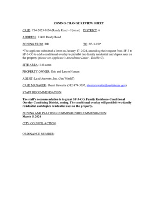
ZONING CHANGE REVIEW SHEET CASE: C14-2023-0154 (Randy Road – Hyman) DISTRICT: 6 ADDRESS: 11401 Randy Road ZONING FROM: DR TO: SF-3-CO* *The applicant submitted a letter on January 17, 2024, amending their request from SF-3 to SF-3-CO to add a conditional overlay to prohibit two-family residential and duplex uses on the property (please see Applicant’s Amendment Letter - Exhibit C). SITE AREA: 1.48 acres PROPERTY OWNER: Eric and Laurie Hyman AGENT: Land Answers, Inc. (Jim Wittliff) CASE MANAGER: Sherri Sirwaitis (512-974-3057, sherri.sirwaitis@austintexas.gov) STAFF RECOMMENDATION: The staff’s recommendation is to grant SF-3-CO, Family Residence-Conditional Overlay Combining District, zoning. The conditional overlay will prohibit two-family residential and duplex residential uses on the property. ZONING AND PLATTING COMMISSION RECOMMENDATION: March 5, 2024 CITY COUNCIL ACTION: ORDINANCE NUMBER: C14-2023-0154 ISSUES: N/A CASE MANAGER COMMENTS: 2 The property in question is currently developed with a single-family residence, with a separate garage structure. There are single-family residences to the north, south, east and west. The applicant has stated that the primary reason that they are requesting SF-3 zoning is to comply with the city’s impervious cover limit of 45%. The applicant’s intent is to replace the existing garage with a new garage that is connected to the main house with a breezeway. Above the garage will be a guest house to be used primarily by the property owner’s adult children. The staff recommends SF-3-CO, Family Residence-Conditional Overlay Combining District, zoning at this location. The property meets the intent of the SF-3 zoning district and it is surrounded by existing single-family residential uses and will maintain single-family neighborhood characteristics. The lot under consideration is 1.48 acres and currently does not meet the minimum lot size requirements for the existing DR zoning of 10 acres. The applicant’s request for SF-3 zoning will bring the lot into conformance with site development standards regarding lot size and impervious cover. Neighbors that own property within this subdivision have notified the staff that there is a deed restriction that limits these lots to one single-family residence (please see Anderson Mill Oaks Deed Restriction - Exhibit D). The applicant has stated that they are aware of the deed restriction which states that there will be no detached garages and only one residence per property. The applicant agrees with the staff’s recommendation. BASIS OF RECOMMENDATION: 1. The proposed zoning should be consistent with the purpose statement of the district sought. Family Residence district is intended as an area for moderate density single-family residential use, with a minimum lot size of 5,750 square feet. Duplex use is permitted under development standards which maintain single-family neighborhood characteristics. This district is appropriate for existing single-family neighborhoods having typically moderate sized lot patterns, as well as for development of additional family housing areas with minimum land requirements. 2. The proposed zoning should promote consistency and orderly planning. The property in question is surrounded by existing single-family residential uses within a platted residential subdivision. C14-2023-0154 3 3. The proposed zoning should allow for a reasonable use of the property. The proposed SF-3-CO zoning will permit the applicant to bring the property into compliance with site development standards regarding minimum lot size and maximum impervious cover. EXISTING ZONING AND LAND USES: ZONING LAND USES Site DR North DR South DR DR East DR West Single-Family Residence Single-Family Residence Single-Family Residence Single-Family Residence Single-Family Residence NEIGHBORHOOD PLANNING AREA: N/A WATERSHED: Bull Creek Watershed NEIGHBORHOOD ORGANIZATIONS: 2222 Coalition of Neighborhood Associations, Inc. Austin Lost and Found Pets Bull Creek Foundation Canyon Creek H.O.A. Friends of Austin Neighborhoods Long Canyon Homeowners Assn. Long Canyon Phase II & III Homeowners Assn Inc. Mountain Neighborhood Association (MNA) Neighborhood Empowerment Foundation SELTexas Sierra Club, Austin Regional Group TNR BCP - Travis County Natural Resources SCHOOLS: Round Rock I.S.D. Spicewood Elementary School Canyon Vista Middle School Westwood High School C14-2023-0154 4 CASE HISTORIES: NUMBER C14-2019-0113 (11408 Antler Lane) REQUEST DR to SF-1 COMMISSION 10/01/19: Approved staff’s recommendation of SF-1 zoning by consent (10-0); H. Smith-1st and N. Barrera-Ramirez-2nd. CITY COUNCIL 10/31/19: The public hearing was conducted and a motion to close the public hearing and approve Ordinance No. 20191031-041 for single-family residence-large lot (SF-1) district zoning was approved on Council Member Tovo, s motion, Council Member Renteria's second on a 10-0 vote. Council Member Casar was off the dais. 2/11/10: Approved LR-CO district zoning on consent (6-0, Cole-off dais); Spelman-1st, Morrison-2nd DR to LR C14-2009-0097 (11505 Anderson Mill Road Rezone) 02/02/10: Approved LR-CO zoning by consent (7-0); D. Tiemann-1st, S. Baldridge-2nd, with the following conditions from the applicant’s agreement with the neighborhood: 1) Limit the site the 1,333 vehicle trips per day; 2) Prohibit the following uses on the site: Consumer Convenience Services, Restaurant (Limited), Service Station; College and University Facility Facilities, Day Care Services (Commercial), Day Care Services (General), Day Care Services (Limited), Private Primary Educational Facilities, Private Secondary Educational Facilities, Public Primary Educational Facilities, Public Secondary Educational Facilities, Safety Services, Group Home, Class I (General), Group Home, Class II, Drive-In Services; 3) Prohibit buildings greater than 1-story to be located within 75 feet of the eastern property line; 4) Restrict the Food Sales, General Retail Sales (Convenience) and General Retail Sales (General) uses to hours of operation from 7:00 a.m. to 8:00 p.m. and limit these uses to ground/1st floor C14-2023-0154 5 occupancy within a structure on the site. 5/19/09: Approved staff’s recommendation of LR-CO zoning with conditions by consent (7-0); K. Jackson-1st, T. Rabago-2nd. 6/11/08: Approved LR-CO with conditions on all3 readings (6-0, Cole-absent); B. McCracken-1st, L. Morrison-2nd. C14-2009-0038 DR to LR (On May 8, 2009, the agent for this case sent the staff an e-mail amending the requested zoning from GR to LR) GR-CO to CS C14-04-0028 C14-04-0027 GR-CO to CS-1 4/15/04: Approved ZAP recommendation of CS zoning (7-0); 1st reading 4/22/04: Approved CS zoning (6-0), McCracken-off dais); 2nd/3rd readings 4/15/04: Pulled off agenda. Case re- noticed and sent back to ZAP Commission. 6/10/04: Granted CS-1 (7-0); all 3 readings 9/25/03: Approved GR-CO & RC-for TIA recommendations (7-0); all 3 readings 1/30/03: Granted GR-CO on 1st reading (7-0) 3/6/03: Approved (7-0); 2nd/3rd readings 3/16/04: Approved staff’s recommendation of CS zoning by consent (8-0, K. Jackson- absent); J. Martinez-1st, J. Gohil- 2nd. 3/16/04: Approved staff’s recommendation of CS-1 zoning by consent (8-0, K. Jackson- absent); J. Martinez-1st, J. Gohil- 2nd. 5/4/04: Approved staff’s recommendation of CS-1 zoning by consent (5-0, J. Martinez, J. Pinnelli, C. Hammond-absent); J. Gohil-1st, J. Donisi-2nd. 8/26/03: Approved staff’s recommendation of GR-CO zoning by consent (8-0, K. Jackson-absent) • 300’ (depth) x 400’ parallel to FM 620, will have ‘LR’ uses only (Tract 2); conditions set out by staff in the T.I.A.; • • No Pawn Shop Services; • No Adult Oriented Businesses; • No Automotive Uses (Vote: 7-0, A. Adams-absent) Approved GR-CO, LO-CO, and LR-CO w/ conditions (8-0) C14-03-0111 DR to GR-CO C14-02-0041 SF-2, DR to GR 11/19/02: Approved staff’s recommendation of GR-CO zoning with conditions of: C14-95-0167 SF-2 to MF-2 Approved GR-CO, LO-CO, & LR-CO subject to conditions C14-2023-0154 6 C14-94-0124 DR to SF-2 Approved SF-2-CO w/ conditions (9-0) C14-93-0032 SF-2, DR to GR Approved GR-CO as recommended (5-0); 1st reading Approved GR-CO (SW area); LO-CO (NE 300’); LR-CO (NW 300’) (7-0); 2nd/3rd readings Approved SF-2-CO w/ conditions (5-0); 1st reading Approved SF-2-CO (5-0); 2nd/3rd readings Approved GR-CO w/ conditions (5-0), 1st reading Approved GR-CO (7-0); 2nd/3rd readings RELATED CASES: Subdivision: Lot 10, Anderson Mill Oaks Addition, a subdivision in Travis County, according to the Map or Plat thereof recorded in Volume 16, Page 96, Plat Records of Travis County, Texas. C14-2023-0154 7 OTHER STAFF COMMENTS: Comprehensive Planning Project Name and Proposed Use: 11401 RANDY ROAD. C14-2023-0154. Project: Randy Road – Hyman. 1.48 acres from DR to SF-3. Existing: Single Family Residence. Proposed: Single Family Residence. Yes Imagine Austin Decision Guidelines Complete Community Measures * Imagine Austin Growth Concept Map: Located within or adjacent to an Imagine Austin Activity Center, Imagine Austin Activity Corridor, or Imagine Austin Job Center as identified the Growth Concept Map. Names of Activity Centers/Activity Corridors/Job Centers *: Mobility and Public Transit *: Located within 0.25 miles of public transit stop and/or light rail station. Mobility and Bike/Ped Access *: Adjoins a public sidewalk, shared path, and/or bike lane. Y Connectivity, Good and Services, Employment *: Provides or is located within 0.50 miles to goods and services, and/or employment center. Connectivity and Food Access *: Provides or is located within 0.50 miles of a grocery store/farmers market. Connectivity and Education *: Located within 0.50 miles from a public school or university. Connectivity and Healthy Living *: Provides or is located within 0.50 miles from a recreation area, park or walking trail. Connectivity and Health *: Provides or is located within 0.50 miles of health facility (ex: hospital, urgent care, doctor’s office, drugstore clinic, and/or specialized outpatient care.) Housing Choice *: Expands the number of units and housing choice that suits a variety of household sizes, incomes, and lifestyle needs of a diverse population (ex: apartments, triplex, granny flat, live/work units, cottage homes, and townhomes) in support of Imagine Austin and the Strategic Housing Blueprint. Housing Affordability *: Provides a minimum of 10% of units for workforce housing (80% MFI or less) and/or fee in lieu for affordable housing. Mixed use *: Provides a mix of residential and non-industrial uses. Culture and Creative Economy *: Provides or is located within 0.50 miles of a cultural resource (ex: library, theater, museum, cultural center). Culture and Historic Preservation: Preserves or enhances a historically and/or culturally significant site. Creative Economy: Expands Austin’s creative economy (ex: live music venue, art studio, film, digital, theater.) Workforce Development, the Economy and Education: Expands the economic base by creating permanent jobs, especially in industries that are currently not represented in a particular area or that promotes a new technology, and/or promotes educational opportunities and workforce development training. Industrial Land: Preserves or enhances industrial land. Not located over Edwards Aquifer Contributing Zone or Edwards Aquifer Recharge Zone 1 Number of “Yes’s” C14-2023-0154 Environmental 8 The site is located over the Edwards Aquifer Recharge Zone. The site is in the Bull Creek Watershed of the Colorado River Basin, which is classified as a Water Supply Suburban Watershed by Chapter 25-8 of the City's Land Development Code. It is in the Drinking Water Protection Zone. Under the current watershed regulations, development or redevelopment on this site will be subject to the following impervious cover limits: Development Classification One or Two Family Residential 30% 40% Multifamily Residential 40% Commercial % of Net Site Area % NSA with Transfers 40% 55% 55% Development within a Water Quality Transition Zone is limited to 18%. According to floodplain maps there is no floodplain within or adjacent to the project location. Standard landscaping and tree protection will be required in accordance with LDC 25-2 and 25-8 for all development and/or redevelopment. At this time, site specific information is unavailable regarding vegetation, areas of steep slope, or other environmental features such as bluffs, springs, canyon rimrock, caves, sinkholes, and wetlands. Under current watershed regulations, development or redevelopment requires water quality control with increased capture volume and control of the 2-year storm on site. At this time, no information has been provided as to whether this property has any preexisting approvals that preempt current water quality or Code requirements. Fire No comments. Parks and Recreation Parkland dedication will be required for the new applicable uses proposed by this development, single family with SF-3 zoning, at the time of subdivision or site plan, per City Code § 25-1-601. The requirement may be met with fees in-lieu of dedicated land per the criteria in City Code Title 25, Article 14, as amended. Should fees in-lieu be required, those fees shall be used toward park investments in the form of land acquisition and/or park amenities within the surrounding area, per the Parkland Dedication Operating Procedures § 14.3.11. C14-2023-0154 9 If the applicant wishes to discuss parkland dedication requirements in advance of site plan or subdivision applications, please contact this reviewer: thomas.rowlinson@austintexas.gov. At the applicant’s request, PARD can provide an early determination of whether fees in-lieu of land will be allowed. Site Plan No comments. Transportation The Austin Strategic Mobility Plan (ASMP) calls for 58 feet of right-of-way for Randy Rd. It is recommended that 29-feet of right-of-way from the existing centerline should be dedicated for Randy Rd according to the ASMP with the first subdivision or site plan application. [LDC 25-6-51 and 25-6- 55]. The adjacent street characteristics table is provided below: Name ASMP Classification ASMP Required ROW Existing ROW Existing Pavement Sidewalks Bicycle Route Capital Metro (within ¼ mile) Randy Rd Local (1) 58 ft 53 ft approx. 17 ft No No 0.75 miles Austin Water Utility No comments on zoning change. FYI: The landowner intends to serve the site with existing City of Austin water utilities. Based on current public infrastructure configurations, it appears that service extension requests (SER) will be required to provide service to this lot. For more information pertaining to the Service Extension Request process and submittal requirements contact the Austin Water SER team at ser@austintexas.gov. INDEX OF EXHIBITS TO FOLLOW A: Zoning Map B. Aerial Map C. Applicant's Amendment Request Letter D. Anderson Mill Oaks Deed Restriction E. Comments Received ( C14-2009-0097 ( ( ( ( ( I-SF-2 ( DR R LN E TL N A ( ( ( ( ( ( ( ( ( ( I-SF-2 ( ( ( M O R N I N G G ( ( I-SF-2 L O ( R Y T R L ( ( ( ( ( ( ( ( ( ( ( ( ( ( ( L R T R E T A W T E E W S ( ( ( ( ( ( ( I-SF-2 ( ( ( ( ( ( ( ( ( ( L R T W E I V R A T S ( ( ( ( I-SF-2 ( C14-2019-0113 ( DR ( ( R T D E N O M 94-0124 T E C N N A Z E C I-SF-2 ( ( SF-2-CO UNDEV 94-0124 94-0124 94-0124 L L P EL W K C O R M ATIS S E T R L 94-0124 SF-2-CO C EZA N N E ST SF-2-CO T L C L E W K C O R 94-0124 L R L T NIA N E T N E C EXHIBIT A 99-0122 ALISON PARKE TRL SF-2-CO SF-2-CO T E R R A C E P A R K E T R L L R T E K R A P N O D N A R B SF-2-CO UNDEV 99-0122 SF-6-CO SP-00-2160C 99-0122 DR A N D E R S O N M I L L R D I R C H C T A W A S L R L T NIA N E T N E C SF-2 I-SF-2 T A L L O A K T R L I-SF-2 L R T T E K C H T I L R T E T I C L A C I-SF-2 I-SF-2 ( ( ( ( SANDY LOAM TRL ( ( ( ( I-SF-2 ( ( ( ( ( ( ( ( ONYX CV ( ( ( ( ( ( ( ( ( ( ( ( DR ( ( ( ( ( L R TAIN T ( ( ( ( ( ( ( SF-1 N U O S M S A L G ( ( ( SF-1 ( ( ( ( ( ( SF-1 ( R N D M I E A J O S ( SF-1 ( DR ( ( ! ! ! ! ! ( ! ! ! ! ! ! ! ! ( ! ! ! ! ! ! ! ( A C N A BLA R R SIE C A D E CIR DR ( R A N D Y R D ( 94-0068 SF-1-CO ( C A T S SF-2 K I L L T R L SF-2 ( ( SF-2 DR ( SF-2 ( DR SF-2 T C I R O O R E T B I T DR DR SUBJECT TRACT ! ! ! ! ! ! PENDING CASE ZONING BOUNDARY ZONING ZONING CASE#: C14-2023-0154 This product is for informational purposes and may not have been prepared for or be suitable for legal, engineering, or surveying purposes. It does not represent an on-the-ground survey and represents only the approximate relative location of property boundaries. 1 " = 400 ' This product has been produced by the Planning Department for the sole purpose of geographic reference. No warranty is made by the City of Austin regarding specific accuracy or completeness. Created: 12/19/2023 SF-2 SF-1-CO 94-0068 LA U R E L C R E E K D R 94-0068 SF-1-CO C O N C H O SF-1-CO S C V SF-2 ± SF-1-CO 94-0068 94-0068 RR 94-0068 SF-1-CO C O N C H O S T R L EXHBIT B !!!!!!!!!!!!!!!!!!!!!(!(!(!(!(!(!(!(!(!(!(!(!(!(!(!(!(!(!(!(!(!(!(!(!(!(!(!(!(!(!(!(!(!(!(!(!(!(!(!(!(!(!(!(!(!(!(!(!(!(!(!(!(!(!(!(!(!(!(!(!(!(!(!(!(!(!(!(!(!(!(!(!(!(!(!(!(!(!(!(!(!(!(!(!(!(!(!(!(!(!(!(!(!(!(!(!(!(!(!(!(!(!(!(!(!(!(!(!(!(!(!(!(!(!(!(!(!(!(!(!(!(!(!(!(E37E38F37F38C14-2023-0154C14-2019-0113C14-2009-0097ANDERSONMILLRDCENTENNIALTRLRANDYRDSIERRABLANCAMONETDRCEZANNESTCONCHOSTRLGLASSMOUNTAINTRLCATSKILLTRLMORNINGGLORYTRLSTARVIEWTRLMATISSETRLCONCHOSCVTHICKET TRLANTLERLNTALLOAKTRLALISON PARKE TRLROCKWELLCTSWEETWATERTRLSANDYLOAMTRLBRANDONPARKETRLJAMIESONDRROCKWELLPLCADECIRONYXCVLAUREL CREEK DRCALCITETRLBITTEROOTCIRCEZANNECTTERRACEPARKETRLSAWATCH CIRCENTENNIALTRLDRDRDRSF-2SF-2RRDRSF-6-COSF-2-COSF-2SF-2-CODRSF-1-COI-SF-2SF-1SF-1I-SF-2I-SF-2SF-1-COSF-2-COI-SF-2DRSF-2DRSF-1-COSF-1-COI-SF-2SF-1SF-1-COSF-2I-SF-2DRDRSF-2-COI-SF-2SF-2-COSF-2I-SF-2SF-2-COI-SF-2I-SF-2SF-1SF-1-COI-SF-2DRSF-2SF-2Randy Road - Hyman±This product has been produced by the Planning Department for the sole purpose of geographic reference. No warrantyis made by the City of Austin regarding specific accuracy or completeness.ZONING CASE#:LOCATION:SUBJECT AREA:GRID:MANAGER:C14-2023-015411401 Randy Rd1.48 AcresE37Sherri SirwaitisCreated: 1/24/2024SUBJECT TRACTZONING BOUNDARY!!!!!!PENDING CASECREEK BUFFER0200400600800100Feet EXHIBIT C EXHIBIT D EXHIBIT E Roger FerrisX11405 Rockwell Place, Austin 7872602/28/2024512-924-4065I generally object to any rezoning of properties on Randy Rd to SF-3including the property at 11401 Randy Rd that is the subject of this case. I believethe appropriate rezoning for lots on Randy Rd in the Anderson Mill Oaks Additionshould be to SF-1, Single Family Large Lot, including any conditional overlays. Thiszoning is appropriate for lots larger than 10,000 square feet.Please see the attached page for further comments. Zoning and Pla�ng Commission For scheduled hearing on March 5, 2024, 6:00 PM Re: Case Number C14-2023-0154 Atn: Sherri Sirwai�s, Contact Person Con�nua�on page for sta�ng objec�on to proposed rezoning at 11401 Randy Rd, Aus�n Submited by: Roger Ferris, property owner and resident at 11405 Rockwell Place, Aus�n, Estates of Brentwood subdivision. Rockwell Place and Rockwell Court are one block west of Randy Road, the loca�on of the zoning change request. The backyard of my lot and the 11 other lots with homes on the east side of Rockwell Place and Rockwell Court abut the backyards of lots on Randy Road. I believe that the only appropriate zoning change to the lot at 11401 Randy Road should be to SF-1-CO, Single Family Large Lot, due to the size of that lot (64,406 square feet). This zoning would be consistent with the SF-1 defini�on, intended for low density single-family residen�al use on lots with a minimum of 10,000 square feet, and is consistent with the character and makeup of the Randy Road and con�guous neighborhoods for the following reasons: 1. There are three addi�onal lots at the end of Randy Road in the Laurel Canyon subdivision, each zoned SF-1-CO, with an average lot size of 46,439 square feet. 2. There are 12 lots on Randy Road (a 1-block long street) in the Anderson Mill Oaks Addi�on, all of which are currently zoned DR, Development Reserve. The average area of these 12 lots is 62,678 square feet. 3. The 12 lots with residences on the east side of Rockwell Place and Rockwell Court in the Estates of Brentwood subdivision whose property borders proper�es on Randy Road are all zoned SF-2- CO, Single Family Standard Lot. These 12 lots range in area from 9,162 square feet to 19,149 square feet, with an average area of 10,431 square feet. If SF-3 zoning is approved for the subject lot, it is reasonably possible that every other lot on Randy Road currently zoned DR could be granted the same SF-3 zoning if requested. Based on current lot sizes, SF-3 minimum lot size of 5,750 square feet, and absent other restric�ons, the 12 lots on Randy Road in the Anderson Mill Oaks Addi�on hypothe�cally could be redeveloped to contain 126 homes. 4. 5. Such intense redevelopment likely would be inconsistent with the reason current Randy Road residents purchased their large proper�es. Those proper�es have a rural character, including water wells, large workshops and other outbuildings, and livestock such as geese, roosters and chickens. 6. Such intense development also would be inconsistent with the SF-2 character of the adjoining Estates of Brentwood subdivision.