04 SP-2023-0053C - Howard Plaza Warehouse 3 Addition.pdf — original pdf
Backup
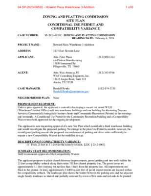
ZONING AND PLATTING COMMISSION SITE PLAN CONDITIONAL USE PERMIT AND COMPATIBILITY VARIANCE CASE NUMBER: SP-2023-0053C ZONING AND PLATTING COMMISSION HEARING DATE: February 6, 2024 PROJECT NAME: Howard Plaza Warehouse 3 Addition ADDRESS: 3127 East Howard Lane APPLICANT: (512) 989-1362 AGENT: (512) 343-0766 Attn: Peter Pham c/o Platron Manufacturing 13930 Immanuel Rd. Pflugerville, TX 78660 Attn: Way Atmadja, PE WAY Consulting Engineers, Inc. 11615 Angus Road, Suite 119 Austin, TX 78759 CASE MANAGER: Randall Rouda Randall.Rouda@austintexas.gov (512) 974-3338 NEIGHBORHOOD PLAN: None PROPOSED DEVELOPMENT: Under a prior approval, the applicant is currently developing a vacant lot, zoned W/LO (Warehouse/Limited Office) with two warehouse buildings and one building for alternating Daycare Services (Commercial) during daily business hours and Community Recreation (Private) in the evenings and weekends. A Conditional Use Permit for the Community Recreation building and a Compatibility Waiver were both approved for the ongoing development. The applicant is now requesting approval of a new Site Plan which would add a third warehouse building and would reconfigure the proposed parking. No change to the prior Use Permit is needed, however, the reconfigured parking amends the proposed encroachments of parking and drive aisles sufficiently to require a new Compatibility Waiver for the modified design. DESCRIPTION OF COMPATIBILITY VARIANCE: 1) From 25 feet to 5.1 feet for the easterly setback. [LDC § 25-2-1063] SUMMARY STAFF RECOMMENDATION: Staff recommends approval of the Compatibility Waiver. The applicant proposes to place shared driveway improvements, paved parking and tree wells within the 25 foot compatibility setback along their entire 700 foot shared property line. The paved areas are approximately 5.1 feet (varying but not less than 5 feet) from the property line. All improvements are flush to the ground. In total, approximately 14,000 square feet of paved improvements are located within the compatibility setback. The landscape plan shows the border between the parking area and the adjacent single family residence as shaded and partially screened by a row of live oaks and red oaks to be planted 1 of 604 SP-2023-0053C - Howard Plaza Warehouse 3 Addition in the five foot wide landscaped area east of the paved parking lot. The parcel to the east which creates the compatibility setback is zoned W/LO (Warehouse and Limited Office) and is developed with a single family residence. As the residence is an allowed use in zones more restrictive than SF-5, the compatibility requirements of LDC Article 10 apply. The parcels are under common ownership and the property owner has submitted a letter on behalf of the parcel with the residential use expressing support for the compatibility waiver. The applicant has designed the parking and drive aisles to facilitate future vehicular connection to the adjacent property in anticipation of an eventual conversion to commercial use. Note that the parcel to the west is also developed with residential uses, however, Article 10 does not apply as that parcel is within the ETJ. The subject parcel is unusually narrow, making compliance with the compatibility standards quite challenging. The site is approximately 190 feet in width where compatibility applies, and is approximately 1,480 feet in depth. Further, the development requires a substantial area for wastewater treatment (septic) as the site is beyond the limits of the City of Austin’s wastewater collection infrastructure. The site plan complies with all other compatibility standards. PROJECT INFORMATION TOTAL SITE AREA EXISTING ZONING PROPOSED ZONING WATERSHED WATERSHED ORDINANCE TRAFFIC IMPACT ANALYSIS Not required CAPITOL VIEW CORRIDOR PROPOSED ACCESS FLOOR-AREA RATIO BUILDING COVERAGE IMPERVIOUS COVERAGE PARKING COMPATIBILITY The subject site is bordered by a single-family residential land uses, to the east. The proposed parking improvements within the 25 foot setback are typical for warehouse/industrial projects and do not include any vertical construction components. Both parcels are under common ownership and no objections to the compatibility waiver have been presented to date. The site complies with all other compatibility standard requirements. EXISTING ZONING AND LAND USES Site North South 364,597 sq. ft. W/LO W/LO Harris Branch (Suburban) Comprehensive Watershed Ordinance None E. Howard Lane Allowed/Required Existing Vacant Howard Lane, Vacant and Single family residences Vacant, Critical Water Quality Zone and Critical Environmental Features. 0.18:1 18% 51% 257 0.25:1 N/A% 70% 235 W/LO I-SF-4A PUD N/A N/A N/A N/A LAND USES ZONING 8.37 acres Proposed 2 of 604 SP-2023-0053C - Howard Plaza Warehouse 3 Addition East West ABUTTING STREETS Street W/LO, PUD ETJ Vacant Single Family Residence(s), Vacant Right-of-Way Width 106 feet Pavement Width 58 feet Classification Suburban East Howard Lane NEIGHBORHOOD ORGNIZATIONS: Austin Lost and Found Pets Friends of Austin Neighborhoods Harris Branch Master Association, Inc. Harris Branch Residential Property Owners Assn. Homeless Neighborhood Association Neighborhood Empowerment Foundation North Gate Neighborhood Association North Growth Corridor Alliance Pflugerville Independent School District 3 of 604 SP-2023-0053C - Howard Plaza Warehouse 3 Addition 4 of 604 SP-2023-0053C - Howard Plaza Warehouse 3 Addition 11.25' 9.00' 90.00' 18.00' 9.46' 13.00' 20.00' 150.00' 15.00' 20.00' 150.00' EXIST. SINGLE FAMILY RESIDENCE EXIST. SINGLE FAMILY RESIDENCE COA ETJ 15.00' 20.00' CITY LIMIT LINE ( AT PROPERTY LINE) 150.00' KEARNES DR. E N I L H C T A M 81.00' ' 0 8 . 5 ' 0 0 . 8 1 ' 0 0 . 6 2 ' 0 0 . 8 1 ' 0 0 . 8 1 ' 0 0 . 6 2 ' 0 0 . 8 1 ' 0 5 . 5 ' 0 5 . 7 ' 0 5 . 5 2 E N A L E R F I 9.00' 16 8 2 5' R 25.86' 9.00' 71.10' 8 45.0° DUMPSTER 9.00' 9 7.50' 12 C ' 0 0 . 5 1 26.00' 9.00' 72.00' 9.00' 54.00' 9.00' 27.00' 18.00' 7.46' DUMPSTER ' 0 0 . 0 1 ' 0 0 . 0 1 DOCK O.H. DOOR DUMPSTER 12 9.00' LOT 1 BLOCK A ' 0 0 . 0 9 10 18.00' ' 0 0 . 9 N 19°40'40" E, 1477.16' DOCK FF 660.50 ' 0 0 . 5 2 O.H. DOOR ' 0 0 . 0 1 U E BUILDING - 3 FF = 660.50 Ltd. Warehouse & Dist. = 13,000 SF Admin. & Business Office = 2,000 SF Total = 15,000 SF ' ' 5 4 X 2 1 E C A P S G N D A O L I E N A L E R F I ELEC. METER 6' x 6' RISER ROOM ' 0 0 . 5 7 BICYCLE PARKING 2 SPACES HANDRAIL @ UPPER SIDEWALK AEC BENCH (SHADE SEATING) FF 660.50 FDC ' 0 0 . 0 1 ' 0 0 . 0 0 1 ' 0 0 . 1 1 ' 0 0 . 8 1 ' 0 0 . 8 1 R = 20' ' 0 0 . 0 5 R=25' R = 2 5 ' R=20' OFFICE ENTRANCE O.H. DOOR FF 660.50 Clear Zone R=15' F.H. ' 0 0 . 0 5 R=25' ' 0 0 . 8 1 ' 0 3 . 9 2 9.00' TYP. 9 FIRE LANE 90.00' 9.00' 9.00' 9.00' BUILDING - 2 FF = 667.75 Ltd. Warehouse & Dist. = 13,000 SF Admin. & Business Office = 2,000 SF Total = 15,000 SF ' ' 5 4 X 2 1 E C A P S G N D A O L I E N A L E R F I 6' x 6' RISER ROOM BICYCLE PARKING 2 SPACES HANDRAIL @ UPPER SIDEWALK AEC BENCH (SHADE SEATING) FF 667.75 FDC DOCK O.H. DOOR ' 0 0 . 5 2 ' 0 0 . 0 1 DUMPSTER BUILDING - 1 FF = 675.0 Ltd. Wrhouse & Dist. = 13,000 SF Admin. & Business Office = 2,000 SF Total = 15,000 SF OFFICE ENTRANCE ' ' 5 4 X 2 1 E C A P S G N D A O L I E N A L E R F I 6' x 6' RISER ROOM BICYCLE PARKING 2 SPACES HANDRAIL @ UPPER SIDEWALK AEC BENCH (SHADE SEATING) F.F. 675.0 FDC OFFICE ENTRANCE ELEC. METERS HC PARKING SIGN (TYP.) Clear Zone FF 667.75 O.H. DOOR R=15' ' 0 0 . 0 5 U E R=25' R R = 2 5 ' R=20' 9.00' TYP. 8 FIRE LANE 9.00' 9.00' 9.00' = 2 5 ' R=20' F.H. 8.5 0' T Y P . ' 0 0 . 7 1 7 UE 45.0° FIRE LANE 7.50' 23.50' 48" PB 14 C ' 0 0 . 5 1 UE R =10' R=10' FIRE LANE 7.50' ' 0 0 . 5 1 7 C UE 5.00' UE 48" PB 93 E U 12 C UE 12 C UE ' 0 0 . 5 1 ' 0 0 . 0 1 ' 0 0 . 0 0 1 ' 0 0 . 1 1 ' 0 0 . 8 1 ' 0 3 . 9 2 ' 0 0 . 5 1 ' 2 9 . 6 ' 0 0 . 0 1 ' 0 0 . 0 0 1 ' 0 0 . 1 1 ' 0 0 . 8 1 ' 0 3 . 9 2 ' 0 0 . 5 1 ' 6 4 . 7 9.00' TYP. 8 FIRE LANE 81.00' VAN 9.00' 9.00' 9.00' FIRE LANE F.F. 675.0 Clear Zone O.H. DOOR ' 0 5 . 4 E N A L E R F I E U 8 7 . 5 0' T TRANSF 12 C UE 48" PB TT 16.50' EXISTING ASPHALT DRIVE 90.00' H R 30.75' (EXISTING CONC. DRIVEWAY TO REMAIN) T A O 48" PB 13.85' 30' X 75' J.U.A.E. per Plat FIRE LANE 75.00' 25.46' 35.00' 22.75' 37.25' 35.00' 26.75' 81.00' 42.25' 35.00' 28.50' 45.00' 15.85' 5' BLDG. SETBACK 2.00'6.00'12.51' 86 UE TRANSF U E 9.00' 9 5 ft. Clear Zone ' 0 0 . 5 ' 0 0 . 7 7 ft. Planting Zone FIRE LANE 72.00' 33.41' FIRE LANE R =10' 18.00' U E 8.77' 25.00' 81.00' 84.15' 105.00' 9.00' 15.00' 9.00' 52.50' 9.00' 90.00' 9.00' 90.00' FIRE LANE EXIST. CONC. EXIST. 3,613 Sq. Ft. SINGLE FAMILY RESIDENCE FF = 658.30 N 19°30'30" E, 700.00' EXISTING ASPHALT DRIVE LOT 2 BLOCK A ZONING: LR-MU Ord. # 20220901-118 USE: Residential 15' WW ESMT. DOC. # 2022167428 3131 E HOWARD LANE 15' WW ESMT. DOC. # 2022167428 . R D I S S A O E D A J ) . . W O R . ' 0 5 ( LOT 19 EAST VILLAGE SINGLE FAMILY PH2 COA ETJ PORTION OF 10' E/TE ESMT. TO BE VACATED S 19°30'30" W, 700.00' 10' E/TE (PER PLAT) COA ETJ 37.26' EX. F.H. 552048 BM K C A B T E S . G D L B ' 5 2 ' 0 8 . 9 8 1 , W ' " 5 1 6 3 ° 9 6 N ) T A L P R E P ( . T M S E E T E / ' 5 1 2.00' EX. EX. P.P. P.P. 6.5' R 18' R 8.70' PRIMARY RISER 5.00' 48" PB 10.00' 2.00' OE 25' R 2 5' R REMOVE EXIST. 6' SIDEWALK 7'+ PLANTING ZONE 6' SIDEWALK/ CLEAR ZONE E N A L D R A W O H . E ' 0 0 . 3 6 1 114.00' EX. R.O.W. 77.00' EX. PAVEMENT ' 0 0 . 0 3 Y A W E V R D I . I T S X E T X E N ) . X O R P P A ( ' 5 9 1 FIRE LANE SIGN PER COA STD. 901S-6 EXIST. 6' SIDEWALK TO REMAIN 5 FT. DEDICATED R.O.W. DOC. # 2017038450 (R.O.W. WIDTH = 114 FT.) K C A B T E S . G D L B ' 5 2 ) T A L P R E P ( . T M S E E T E / ' 5 1 ' 4 0 . 0 0 1 , W ' " 5 1 6 3 ° 9 6 N I E N L H C T A M 81.00' ' 0 8 . 5 ' 0 0 8 1 . ' 0 0 . 6 2 ' 0 0 . 8 1 ' 0 0 . 8 1 ' 0 0 . 6 2 ' 0 0 . 8 1 ' 0 5 . 5 ' 0 5 . 7 ' 0 5 . 5 2 86 FIRE LANE 72.00' 33.41' FIRE LANE R =10' 9 0 9 4 # M R F I 5 6 8 3 5 # E P 07/15/23 . C N I I , S R E E N G N E G N I T L U S N O C Y A W y n a p m o C g n i r e e n i g n E l a r u t c u r t S & l i i v C m o c . g n i r e e n i g n e y a w @ l i a m 6 6 7 0 - 3 4 3 ) 2 1 5 ( 9 5 7 8 7 s a x e T , n i t s u A , 9 1 1 e t i u S , d a o R s u g n A 5 0 5 1 1 A Z A L P D R A W O H n o i t i d d A 3 # e s u o h e r a W e n a L d r a w o H . E 7 2 1 3 3 5 6 8 7 s a x e T , n i t s u A L O R T N O C L A N O S N E M D I I N A L P E T S I 22,500 S.F. (5.1%) NATURAL UNDEVELOPED PRIVATE COMMON OPEN SPACE Z Q W C FL 629.0 * 150.00' 16.00' 21.09' 11.66' 11.25' CITY LIMIT LINE ( AT PROPERTY LINE) ' 0 3 0 3 . SHOWERS & LOCKERS 645.0 DUMPSTER 645.0 9.00' 9 ' 0 8 7 1 . 644.0 16.00' 18.00' 26.00' 9.00' 72.00' PERMIT SET NOT FOR DISTRIBUTION TO CONTRACTORS (Reproduction is not permitted unless it is made for governmental review only) 12/15/23 5' BLDG. SETBACK ' 0 3 0 3 . ' 0 0 . 0 2 ' 0 0 . 0 6 6,000 S.F. OUTDOOR PAVILION (ACCESSORY BLDG) F.F. 645.75 100.00' 20.00' BUILDING - 4 FF = 646.75 (COVERED PATIO) Community Recreation (Private) = 10,000 SF Admin. & Business Office = 5,000 SF Total = 15,000 SF RISER ROOM FIRE LANE SIGN PER COA STD. 901S-6 ' 0 0 . 5 ' 0 0 . 7 5 ft. Clear Zone 7 ft. Planting Zone 643.5 F.F. 646.75 FIRE LANE F.H. 7.00' 34.00' FIRE LANE ' 0 0 . 9 7 7 18.00' 27.65' 25.00' 9.00' ' 0 0 . 0 2 ' 0 5 . 2 1 ' 0 5 . 5 2 ' 0 0 . 9 ' 0 0 . 3 6 9.24' ' 0 0 8 1 . ' 0 5 . 2 1 ' 0 5 . 5 2 ' 0 0 . 8 1 ' 0 0 . 9 ' 0 0 . 8 1 ' 0 0 7 2 . ' 0 0 8 1 . ' 3 3 . 4 3 9.00' 16 8 F.F. 646.75 BICYCLE PARKING 8 SPACES 646.5 FDC ELEC. METER 646.5 ' 0 0 10 . 4 0 1 645.25 645.5 645.77 E 645.5 N A L E R F I E N A L E R F I 25' R 2 5' R 16.00' 18.14' 25.86' 9.00' N A V F.H. UE 646.25 19 ' 0 0 . 8 1 630.5 633.5 635.0 635.0 C W Q Z 25' DRAINAGE ESMT. (Doc # 2021217308) ' 0 0 . 5 2 3' x 3' CONT. ROCK GABION LEVEL SPREADER (TOP @ 630.5) DETENTION POND FILTRATION POND SEDIMENTATION POND DE-WATERING SKIMMER REF. FIG. 1.4.5.K.1, SHT. 15 630.5 633.5 633.5 DRAINAGE CHANNEL S 19°30'30" W, 800.00' 6 FT. HT. WOOD SCREEN FENCE AT PROPERTY LINE (LDC 25-2-1006) 99.00' 17.08' 18.00' 71.10' e u T r 9.00' 11 8.5 0' T Y P . 8 45.0° 645.5 646.0 13 121.50' 5.00' LOT 1 BLOCK A 9.00' 153.00' 9.00' 9.00' 11 ' 0 0 . 8 1 9.00' 99.09' 9.00' 63 135.18' 9.00' 17 9.00' ' 0 0 8 1 . 15 25' DRAINAGE ESMT. (Doc # 2021217308) E N I L H C T A M 1" = 30'-0" PLAN NORTH 0 15 30 60 Revisions/Issues: Sheet 5 of 27 EXPIRATION DATE: APPLICATION DATE: 02-13-2023 SITE PLAN RELEASE: FILE NUMBER: CASE MANAGER: SP-2023-0053C Randall Rouda APPROVED ADMINISTRATIVELY ON: APPROVED BY PLANNING COMMISSION ON: APPROVED BY CITY COUNCIL ON: 112 Under Section of Chapter 25-5 Development Services Department DATE OF RELEASE Rev. 1 Rev. 2 Correction 1 Correction 2 CASE #: SP-2023-0053C of the Austin City Code. Zoning: W / LO Drawn by: Job No. Sheet No. 18112 5 27 OF SUBMITTAL DATE: 02-13-2023 R=10' 48" PB ' 4 0 . 0 0 1 W ' " 5 1 6 3 ° 9 6 N 4.00' 11 ' 0 0 . 8 1 9.00' 63 135.18' 99.09' 9.00' 25.00' ' 0 0 8 1 . 15 25' DRAINAGE ESMT. (Doc # 2021217308) I E N L H C T A M N 10114489.8034 E 3150370.7164 S E R C A 3 5 0 3 . 4 6 3 ) 0 8 5 8 4 0 1 1 0 2 . C O D ( ) E N I L Y T R E P O R P T A ( E N I L T I M I L Y T I C ' 2 7 . 4 9 1 ' 4 0 . 5 9 2 , W ' " 9 5 8 0 ° 6 6 N I T F 0 5 N H T I W S G N D L I U B O N I D U P : I G N N O Z ' 2 3 . 0 0 1 E C N E F K N I L N A H C I . X E W W E (VOL.10860, PG.94) All activities within the Critical Environmental Feature and associated CEF setback must comply with the City of Austin Land Development Code. The natural vegetative cover must be retained to the maximum extent practicable; construction is prohibited; and wastewater disposal or irrigation is prohibited. 150 FT. C E F S E TB A C K K C A B T E S . G D L B ' 5 2 K C A B T E S . G D L B ' 5 2 10' E/TE (PER PLAT) 5 of 604 SP-2023-0053C - Howard Plaza Warehouse 3 Addition l l i w l g w d . s d u o c o n v e r a z a p d r a w o h \ r o n a m l i l i l , n o s v e r n a p e t i s a z a p d r a w o h \ g n i r e e n g n e y a w _ r o n a m i i i l j l , n o s v e r n a p e t i s a z a p d r a w o h \ s t c e o r p \ x o b p o r d a b \ : d M A 6 4 : 1 1 3 2 0 2 / 5 2 / 8 l l r i a b l l i w AREA = 1.30 ACRES LENGTH = 235.96' 235.96' AREA = 2.52 ACRES LENGTH = 579.76' 579.76' Landscape screen per 2.6 Refer Landscape Plan Landscape screen per 2.6 Refer Landscape Plan LOC N 19°40'40" E, 1477.16' PHASE II 2 3 12 C 2 1A 2 3 NR NR NR NR NR NR NR NR NR NR DOCK 2 O.H. DOOR (1) MO1.5 1A PHASE II BUILDING - 3 FF = 660.50 2 NR NR NR NR NR NR NR NR NR NR DOCK 2 3 2 O.H. DOOR DUMPSTER LOC 1A PHASE II BUILDING - 2 FF = 667.75 1A (2) MO1.5 1A 12 650 LOT 1 BLOCK A DUMPSTER 1A SHADE TREES, 1.5" CALIPER · 1.5" PARKING 10 8 4 6 86 9 PHASE I 4 6 (All ponds, site works, utilities, & Bldg 4) 651 Partial Compliance per SubChapter E 1.2.3.A (Sidewalk one side of ICR) U E 1 - LO1.5 652 (6) SHADE TREES, 1.5" CALIPER · 1.5" INTERNAL CIRCULATION ROUTE 5 ft. Clear Zone 9 TRANSF 1A 1A SHADE TREE, 1.5" CALIPER · 1.5" PARKING ACCESSIBLE ROUTE UE 1 - MO1.5 U E ' 0 0 0 5 . ' ' 5 4 X 2 1 E C A P S G N D A O L I E N A L E R F I 653 ELEC. METER 6' x 6' RISER ROOM (1) LO1.5 FDC 1A 1 - MS1.5 SHADE TREE, 1.5" CALIPER · 1.5" PARKING, I.C.R. FIRE LANE 7 ft. Planting Zone ROOT BARRIER SHADE TREE, 1.5" CALIPER · 1.5" PARKING U E FIRE LANE 1 - MS1.5 1A 1A 1 - MS1.5 ROOT BARRIER 1 - MS1.5 ROOT BARRIER 7 UE (3) SRO1.5 1A 48" PB SHADE TREE, 1.5" CALIPER · 1.5" PARKING ICR Shade Trees 30' o.c. per 2.2.5.E.b.ii & 2.2.3.B.1 Refer Landscape Plan FIRE LANE 1 - MS1.5 ROOT BARRIER 14 C UE (4) SRO1.5 LOC 6 5 7 (7) SHADE TREES, 1.5" CALIPER · 1.5" INTERNAL CIRCULATION ROUTE (3) LO1.5 EXIST. CONC. 8 5 6 I E N L H C T A M 1A 645 DUMPSTER (1) MO1.5 9 1 - MO1.5 Entry Shade w/ trees per 2.8.2.A.4. Refer Landscape Plan 1 - LO1.5 16 SHADE TREE, 1.5" CALIPER · 1.5" PARKING 1 - LO1.5 1A 1A 646 1A E N A L E R F I 8 1A Entry Shade Awning 6 per 2.8.2.A.4 6 4 7 (4) LO1.5 1 T E E H S E E ROOT BARRIER S E N I L H C T A M (3) LO1.5 8 1A 1A 11 TREE, 1.5" CALIPER 1.5" PARKING, I.C.R. SHADE TREES, 1.5" CALIPER 1.5" INTERNAL CIRCULATION ROUTE 9 4 6 63 0 5 6 15 1 - MS1.5 652 1 5 6 1 - MS1.5 25' DRAINAGE ESMT. (Doc # 2021217308) 6 5 0 1 5 6 6 5 2 LOC E N I L H C T A M 1A 48" PB ' 4 0 . 0 0 1 W ' " 5 1 6 3 ° 9 6 N 653 Angle parking per 2.2.5.G.2 this side of ICR 654 5 5 6 6 5 6 7 5 6 LOC 15' WW ESMT. DOC. # 2022167428 653 4 5 6 LOC 5 5 6 LOT 1 EAST VILLAGE SINGLE FAMILY PH2 C8-2018-0122.3B Zoning: PUD ' 9 7 . 4 0 1 C O L C O L " A " L S S " 8 1 . X E 2 3 ' ' 5 4 X 2 1 E C A P S G N D A O L I E N A L E R F I EXIST. SINGLE FAMILY RESIDENCE COA ETJ EXIST. SINGLE FAMILY RESIDENCE Landscape screen per 2.6 Refer Landscape Plan 2 NR NR 2 2 NR NR NR NR NR 3 NR NR NR DOCK DUMPSTER ' ' 5 4 X 2 1 E C A P S G N D A O L I EX. F.H. 552048 LOC 674673 BM ACCESSIBLE ROUTE PHASE II 1A 5' BLDG. SETBACK PHASE II BUILDING - 1 FF = 675.0 5 - CE1.5 D R A Y T E E R T S K C A B T E S . G D L B ' 5 2 675 C O L 1A ' . 0 8 9 8 1 , W ' " 5 1 6 3 ° 9 6 N 1A ' 4 8 . 9 8 2 , ' E " 5 1 6 3 ° 9 6 S 5 1A 7 6 6 7 6 EX. P.P. 15' E/TE ESMT. (PER PLAT) 673 SHADE TREES, 1.5" CALIPER · 1.5" STREET YARD 676 E N A L D R A W O H . E 654 655 Exempt from Building Placement, Parking between Bldg. & ICR, Planting Zone, & Shading per 1.2.4.9 6 5 6 7 5 6 1A 0 6 6 661 Exempt from Building Placement, Parking between Bldg. & ICR, Planting Zone, & 662 Shading per 1.2.4.9 663 664 665 HANDRAIL @ UPPER SIDEWALK END HANDRAIL PHASE II 8 5 6 HANDRAIL @ UPPER SIDEWALK END HANDRAIL PHASE II ACCESSIBLE ROUTE Clear Zone (Sidewalk) 9 FIRE LANE ' 0 0 0 5 . 9 5 6 1 - LO1.5 1A F.H. SHADE TREES, 1.5" CALIPER · 1.5" PARKING (1) MS1.5 6' x 6' RISER ROOM FDC 1A SHADE TREE, 1.5" CALIPER · 1.5" PARKING ROOT BARRIER Clear Zone (Sidewalk) SHADE TREE, 1.5" CALIPER · 1.5" PARKING 8 SHADE TREE, 1.5" CALIPER · 1.5" PARKING 1 - MS1.5 FIRE LANE (4) SRO1.5 12 C N 19°30'30" E, 700.00' 663 664 UE 1A EXISTING ASPHALT DRIVE LOT 2 BLOCK A ZONING: LR-MU Ord. # 20220901-118 USE: Residential 5 6 6 ROOT BARRIER FIRE LANE 1 - MS1.5 ROOT BARRIER 7 C 659 660 FIRE LANE UE 48" PB 1A ROOT BARRIER Driveway stub-out 1 6 6 for Future Connectivity per 2.3.1.B 2 6 6 668 6' x 6' RISER ROOM Exempt from Building Placement, Parking between Bldg. & ICR, Planting Zone, & 671 9 6 Shading per 1.2.4.9 6 670 2 7 6 HANDRAIL @ UPPER SIDEWALK PHASE II END HANDRAIL ELEC. METERS 666 SHADE TREE, 1.5" CALIPER · 1.5" PARKING 1A 667 ' 0 0 0 5 . U E E N A L E R 1 - MS1.5 F I FDC 1A F.H. ACCESSIBLE ROUTE Clear Zone (Sidewalk) SHADE TREE, 1.5" CALIPER · 1.5" PARKING ROOT BARRIER 6 FIRE LANE 1 - LO1.5 1 - LO1.5 93 Internal Circulation Route (ICR) ROOT BARRIER (4) LO1.5 (12) SHADE TREES, 1.5" CALIPER · 1.5" INTERNAL CIRCULATION ROUTE E U SHADE TREE, 1.5" CALIPER · 1.5" PARKING / ICR SHADE TREE, 1.5" CALIPER · 1.5" PARKING 1 - MS1.5 FIRE LANE ROOT BARRIER 12 C UE (4) SRO1.5 12 C UE TRANSF 669 48" PB TT P P P 48" PB LOC 7 6 6 6 6 6 8 6 6 1 7 6 2 7 6 EXISTING ASPHALT DRIVE LOC 1A P P P P P B B B B B B B SMALL TREES, 1.5" CALIPER · 1.5" STREET YARD SHADE TREE, 1.5" CALIPER · 1.5" PARKING 71 - SPF 1A PRIMARY RISER ROOT BARRIER 1A SHADE TREE, 1.5" CALIPER · 1.5" PARKING (2) YH1.5 VAN 1 - MS1.5 6 3 E U 2 3 2 1A FIRE LANE D R A Y T E E R T S ROOT BARRIER ROOT BARRIER 30' X 70' J.U.A.E. per Plat 6 7 4 6 7 6 673 5 7 6 FIRE LANE EX. CONC. DRIVEWAY LOC 1B Warehouse exempt from Sidewalk & Parking this side of ICR per 1.2.4.9 0 7 6 Exemption 1.2.4.9 Calculation for Warehouse Total Bldgs. 1, 2, & 3 = 45,000 s.f. Non-Industrial Use = 6,000 s.f. 6000 / 45,000 = 13% < 25% Vehicular & Pedestrian Connections per 2.3.1.B.1. a & b (Joint Access Esmt. & Exist. Sidewalk) 1A UE Y A W E N O LOC 15' WW ESMT. DOC. # 2022167428 LOT 19 EAST VILLAGE SINGLE FAMILY PH2 C8-2018-0122.3B Zoning: PUD PORTION OF 10' E/TE ESMT. TO BE VACATED ARTISIAN COVE LIVE-WORK EAST AUSTIN SP-2021-0058C Zoning : PUD (3211 E. Howard Lane) S 19°30'30" W, 700.00' 10' E/TE (PER PLAT) LIVE-WORK BLDG. Parking LIVE-WORK BLDG. LIVE-WORK BLDG. Parking LIVE-WORK BLDG. EX. 2" A. R. VALVE 552035 C O L K C A B T E S . G D L B ' 5 2 l t a P r e P E T E / ' 5 1 4 7 6 1B C O L ' 4 0 . 0 0 1 , W ' " 5 1 6 3 ° 9 6 N 5 FT. DEDICATED R.O.W. DOC. # 2017038450 (R.O.W. WIDTH = 114 FT.) LOC TREE LIST TAG | CALIPER | SPECIES | STATUS No Existing Trees onsite REFERENCE NOTES SCHEDULE PLANT SCHEDULE SYMBOL DESCRIPTION NOTES · If establishing vegetation during any stage of a drought, Section 6-4-30 may require a variance. Contact Austin Water Conservation staff at waterusecompvar@austintexas.gov or call (512) 974-2199. Finished elevation for parking-lot islands, medians, peninsulas, and similar landscape areas must be at least six (6) below the finished curb elevation to allow for placement of six (6) inches of topsoil [ECM 1.4.7] All landscaped areas are to be protected by 6 inch wheel curbs, wheelstops or other approved barriers as per ECM 2.4.7. [LDC 25-2-1004(A), ECM 2.4.7(A)] The Owner will continuously maintain the required landscaping in accordance with LDC Section 25-2-984. The irrigation will comply with City Code Chapter 6-4, Article 2, Division 2 regarding the City’s water conservation restrictions. This project meets the requirements of Chapter 25-2 Article 9 of the Land Development Code. Sprinklers are prohibited within 15 feet of transmission poles. Shrubbery shall not obstruct access to the base of the transmission structures. Climbing vegetation on electric facilities is prohibited. Compost and mulch are prohibited above the concrete foundation of the transmission poles. Provide mulch tree ring for all trees outside of beds. Install per detail #1 on specifications sheet. Provide bubbler. Mulch is in addition to quantities listed. Contractor is responsible for verifying all plant and material quantities. Irrigation sleeves shall be run to all landscaped · · · · · · · · · · · TREE SUMMARY Surveyed: February 28, 2020 Total Appendix F tree inches surveyed; 0 Heritage tree inches surveyed; 0 Non-Appendix F tree inches surveyed; 0 Invasive tree inches surveyed; 0 Removed: Total Appendix F inches removed; 0 Heritage Tree inches removed; 0 Total Non-Appendix F inches removed; 0 Invasive inches removed; 0 Total Dead, Diseased, or Imminent Hazard (DDI) inches removed; 0 DDI Appendix F inches removed; 0 DDI Heritage tree inches removed; 0 DDI Non-Appendix F inches removed; 0 DDI Invasive inches removed; 0 Mitigation: Total mitigation replacement inches planted; 0 Total replacement inches planted on site (private trees); 0 Total replacement ROW inches planted; 0 Private inches owed to Urban Forest Replenishment Fund (UFRF) 0 Public inches owed to UFRF 0 Total non-mitigation inches planted on site 46.5" 1A 1B 1C 2 3 4 Lawn, Bermuda "Latitude 36" Sod, provide 2" of topsoil tilled into existing. Top of lawn 1" below top of adjacent concrete/hardscape. Flatten sod with lawn roller. Provide spray irrigation. Temporary irrigation only within septic fields or Right of Way (R.O.W.). Pre emergent weed treatment recommended. Lawn, Bermuda "Blackjack" Hydromulch. Include Perennial Ryegrass if planted in cool season. Provide 2" of additional top soil. Tackifier additive for hydromulch. Spray irrigation. Temporary irrigation only within septic fields or Right of Way (R.O.W.). Temporary irrigation until established if outside of property line. Pre emergent weed treatment recommended. Lawn, Native Grass 609S Seed Mix. Upland Species, Shade-Dappeled Light Mix by C.O.A. 609 S standards where existing is diusturbed. Mix listed on spec sheet. Hydromulch w/tackifier agent. Temporary irrigation. Provide 6" of topsoil where existing is insufficient (specified below). Availible through www.seedsource.com Steel edge, 3/16" x 4" landscape edging as manufactured by Ryerson, or equal, dark green and furnished with steel stakes. Install edging in smooth curves free of kinks. Final height of edging to be 1" above height of soil mat of sod. Mulch, Native Hardwood. 3" deep with 6" of "Growers Mix" soil (40% compost, 40% loam, 10% sand) tilled into existing soil in all areas of the bed. Drip irrigation. Ensure that drip line is placed above rootballs. Limit of Turf Type TREES CE1.5 LO1.5 MO1.5 MS1.5 SRO1.5 COMMON NAME Cedar Elm Live Oak Monterey Oak Mexican Sycamore Shumard Red Oak BOTANICAL NAME Ulmus crassifolia Quercus virginiana Quercus polymorpha `Monterey` Platanus mexicana Quercus shumardii ORNAMENTAL TREES NR YH1.5 COMMON NAME Nellie R. Stevens Holly Yaupon Holly BOTANICAL NAME Ilex x `Nellie R Stevens` Ilex vomitoria SHRUBS B P COMMON NAME Blue Plumbago Dwarf Palmetto BOTANICAL NAME Plumbago auriculata Sabal minor GROUND COVERS SPF COMMON NAME Silver Ponyfoot BOTANICAL NAME Dichondra argentea CAL 1.5"Cal 1.5"Cal 1.5"Cal 1.5"Cal 1.5"Cal SIZE 6` H min 6` H min 6` H min 6` H min 6` H min CAL SIZE 1.5"Cal 6` H min SIZE CONT - - - - - CONT 5 gal - CONT 5 gal 5 gal CONT 1 gal QTY 5 28 6 15 22 QTY 30 2 7 8 18" o.c. 71 N O R T H SCALE: 1" = 30' 0 30 60 90 feet Sheet 17 of 27 EXPIRATION DATE: APPLICATION DATE: 04-8-2023 SITE PLAN RELEASE: FILE NUMBER: CASE MANAGER: SP-2023-0053C Randall Rouda APPROVED ADMINISTRATIVELY ON: APPROVED BY PLANNING COMMISSION ON: APPROVED BY CITY COUNCIL ON: 112 Under Section of Chapter 25-5 Development Services Department DATE OF RELEASE Rev. 1 Rev. 2 Correction 1 Correction 2 CASE #: SP-2023-0053C SUBMITTAL DATE: 04-5-2019 of the Austin City Code. Zoning: W / LO Design By: Will Blair Issue Date: 01/11/2019 Project Number: 19003 - LP R Know what's below. Call before you dig. e t a D n o i t p i r c s e D v e R Consultant Seal Company Name and Address 2 1 e t S , t i S n a M W 6 0 3 4 6 6 8 7 X T , k c o R d n u o R m o c . A L r i a B @ l l l i W m o c . A L r i a B w w w . l r i a B l . S m a i l l i W 9 7 9 8 - 2 2 5 ) 2 1 5 ( William S. Blair August 25, 2023 Project Name and Address l a (cid:93) a P d r a w o H n o i t i d d A 3 # e s u o h e r a W e n a L d r a w o H 9 1 1 3 . E 3 5 6 8 7 X T , n i t s u A Sheet Title l n a P e p a c s d n a L 17 6 of 604 SP-2023-0053C - Howard Plaza Warehouse 3 Addition