04 SP-2021-0242C - Loyola Junction Apartments; District 1.pdf — original pdf
Backup
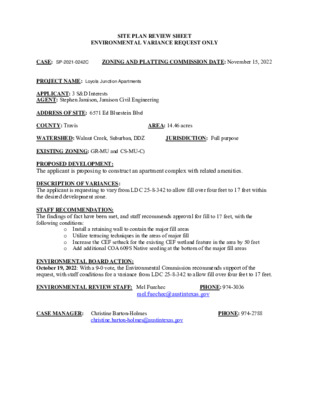
SITE PLAN REVIEW SHEET ENVIRONMENTAL VARIANCE REQUEST ONLY CASE: SP-2021-0242C ZONING AND PLATTING COMMISSION DATE: November 15, 2022 PROJECT NAME: Loyola Junction Apartments APPLICANT: 3 S&D Interests AGENT: Stephen Jamison, Jamison Civil Engineering ADDRESS OF SITE: 6571 Ed Bluestein Blvd COUNTY: Travis WATERSHED: Walnut Creek, Suburban, DDZ JURISDICTION: Full purpose EXISTING ZONING: GR-MU and CS-MU-C) PROPOSED DEVELOPMENT: The applicant is proposing to construct an apartment complex with related amenities. DESCRIPTION OF VARIANCES: The applicant is requesting to vary from LDC 25-8-342 to allow fill over four feet to 17 feet within the desired development zone. STAFF RECOMMENDATION: The findings of fact have been met, and staff recommends approval for fill to 17 feet, with the following conditions: AREA: 14.46 acres Install a retaining wall to contain the major fill areas o o Utilize terracing techniques in the areas of major fill o o Add additional COA 609S Native seeding at the bottom of the major fill areas Increase the CEF setback for the existing CEF wetland feature in the area by 50 feet ENVIRONMENTAL BOARD ACTION: October 19, 2022: With a 9-0 vote, the Environmental Commission recommends support of the request, with staff conditions for a variance from LDC 25-8-342 to allow fill over four feet to 17 feet. ENVIRONMENTAL REVIEW STAFF: Mel Fuechec PHONE: 974-3036 mel.fuechec@austintexas.gov CASE MANAGER: Christine Barton-Holmes christine.barton-holmes@austintexas.gov PHONE: 974-2788 ITEM FOR ENVIRONMENTAL COMMISSION AGENDA COMMISSION MEETING DATE: 11/2/22 NAME & NUMBER OF PROJECT: Loyola Junction Apartments SP-2021-0242C NAME OF APPLICANT OR ORGANIZATION: STEPHEN JAMISON Jamison Civil Engineering LOCATION: 6525 ED BLUESTEIN BOULEVARD NB AUSTIN, Texas, 78724 COUNCIL DISTRICT: District #1 ENVIRONMENTAL REVIEW STAFF: Mel Fuechec, Environmental Review Specialist, Sr, DSD, 512- 974-3036, mel.fuechec@austintexas.gov WATERSHED: Walnut Creek, Suburban Watershed, Desired Development Zone REQUEST: Variance request is as follows: Request to vary from LDC 25-8-342 to allow fill up to 17 feet in the desired development zone. STAFF RECOMMENDATION: Staff recommends this variance, having determined the findings of fact to have been met. STAFF CONDITION: • • Install a retaining wall to contain the major fill areas • Utilize terracing techniques in the areas of major fill Increase the CEF setback for the existing CEF wetland feature in the area by 50 feet • Add additional COA 609S Native seeding at the bottom of the major fill areas Development Services Department Staff Recommendations Concerning Required Findings Project Name: Ordinance Standard: Watershed Protection Ordinance Variance Request: Loyola Junction Apartments Request to vary from LDC 25-8-342 to allow fill up to 17 feet in the desired development zone. Include an explanation with each applicable finding of fact. A. Land Use Commission variance determinations from Chapter 25-8-41 of the City Code: 1. The variance is necessary in order to provide the two required The requirement will deprive the applicant of a privilege available to owners of similarly situated property with approximately contemporaneous development subject to similar code requirements. Yes / No access points for a multifamily project. One access point is through a neighborhood street, Lazy Creek Dr. and is for emergency access only. TXDOT ‘Control of Access’ limitations provide for only one possible general-purpose access point in the location proposed in this variance along US Hwy 183. Due to the elevated nature of US Hwy 183, the proposed 17 feet of fill are required to safely connect the driveway from US Hwy 183 down to the project site. Approved grading variances of similarly situated properties in the adjacent area are: Applied Materials Logistics Service Center (SP-2020-0321C), Crossroads Logistics Center (SP-2021-0015D), and Crossroads Logistics Center (SP-2021- 0169D). 2. The variance: a) Is not necessitated by the scale, layout, construction method, or other design decision made by the applicant, unless the design decision provides greater overall environmental protection than is achievable without the variance; Yes / No Two (2) fire lane / emergency access points are required. TXDOT is restricting the location of the proposed driveway onto Ed Bluestein Blvd. to the proposed location. The retaining wall and highway are elevated approximately 17 feet higher than the natural grade in that location. Is the minimum deviation from the code requirement necessary to allow a reasonable use of the property; Yes / No The site is being graded as efficiently as possible to meet emergency access requirements while minimizing the required fill to do so. b) 3. 1. 2. 3. Does not create a significant probability of harmful environmental consequences. c) Yes / No No harmful environmental consequences will result from the variance. Steps are being taken to mitigate any potential erosion that may result from the grading. Development with the variance will result in water quality that is at least equal to the water quality achievable without the variance. Yes / No Rain gardens, water quality ponds, and detention ponds are proposed throughout the site. All water quality and drainage code requirements are being met. B. The Land Use Commission may grant a variance from a requirement of Section 25-8-422 (Water Supply Suburban Water Quality Transition Zone), Section 25-8-452 (Water Supply Rural Water Quality Transition Zone), Section 25-8-482 (Barton Springs Zone Water Quality Transition Zone), Section 25-8-368 (Restrictions on Development Impacting Lake Austin, Lady Bird Lake, and Lake Walter E. Long), or Article 7, Division 1 ( Critical Water Quality Zone Restrictions ), after determining that:: The criteria for granting a variance in Subsection (A) are met; NA The requirement for which a variance is requested prevents a reasonable, economic use of the entire property; NA The variance is the minimum deviation from the code requirement necessary to allow a reasonable, economic use of the entire property. NA Staff Determination: Staff determines that the findings of fact have been met. Staff recommends the following condition: Install 355 linear feet of retaining wall to contain the major fill areas • • Utilize terracing techniques in the areas of major fill • Increase the CEF setback for the existing wetland CEF feature in the area by 50 feet • Add an additional 7,100 square feet of COA 609S Native seeding at the bottom of the major fill areas Environmental Review (DSD) Environmental Policy Program Manager (DSD) Deputy Environmental Officer (WPD) Mel Fuechec (print name) _____________________________ (Mike McDougal) _____________________________ (Liz Johnston) Date: 8/18/2022 Date: 8/18/2022 Date: 8/19/2022 ENVIRONMENTAL COMMISSION VARIANCE APPLICATION FORM August 10, 2022 Denise Lucas, Director Development Services Department City of Austin P.O. Box 1088 Austin, Texas 78767 RE: Fill Variance Request Letter Loyola Junction Apartments 6571 Ed Bluestein Blvd. SP-2021-0242C LDC 25-8-342 Fill Requirements Dear Ms. Lucas: On behalf of the owner, we are requesting a variance for fill in excess of four (4) feet for the proposed development of the Loyola Junction Apartments site development permit (SP-2021- 0242C) located at 6571 Ed Bluestein Blvd. The subject project is located in the City of Austin’s full purpose jurisdiction, and is zoned GR- MU and CS-MU-CO. The property is currently undeveloped and is located at the northeast corner of the intersection of Ed Bluestein Blvd. (US Hwy. 183) and Loyola Lane. City of Austin | Environmental Commission Variance Application Guide 1 August 10, 2022 This project proposes the construction of 16 apartment buildings, two (2) garages, leasing office and club house, two (2) water quality / detention ponds, two (2) rain garden, two driveway and all associated grading, paving, water, wastewater, and drainage improvements. The applicant proposes to place new improvements on the property in a manner to minimize adverse impacts to the natural character of the property. The site is in the Walnut Creek Watershed, which is a Suburban Watershed. The subject tract is not located over the Edwards Aquifer Recharge Zone. City of Austin | Environmental Commission Variance Application Guide 2 August 10, 2022 With regard to the proposed variance, we respectfully suggest the following conditions be considered as enhancements to the project to support the variances, consistent with City staff guidance: 1. Added retaining walls (355 lf) to contain the major fill areas. 2. Utilized terracing techniques in the area of the major fill areas. 3. Increased setback by 50 feet (0.72 acres) for the existing CEF/Wetland feature 4. Added additional 7,100 sf of COA 609S Native Seeding at the bottom of the major fill areas. The project requires leniency from the following code section: Division 5. ‐ Cut, Fill, and Spoil. § 25-8‐342 ‐ FILL REQUIREMENTS. (A) Fill on a tract of land may not exceed four feet of depth, except: (1) in an urban watershed; (2) in a roadway right‐of‐way; (3) under a foundation with sides perpendicular to the ground, or with pier and beam construction; (4) for construction of a water quality control or detention facility and appurtenances for conveyance such as swales, drainage ditches, and diversion berms, if: the fill is the minimum necessary for the appropriate functioning of the design and location of the facility within the site minimize the (a) amount of fill over four feet; (b) the facility; and (c) 15 percent or within 100 feet of a classified waterway; the fill is not located on a slope with a gradient of more than (5) for utility construction or a wastewater drain field; or (6) in a state‐permitted sanitary located landfill in the extraterritorial jurisdiction, if: floodplain; (a) the fill is derived from the landfill operation; (b) the fill is not placed in a critical water quality zone or a 100‐year the landfill operation has an erosion and restoration plan (c) approved by the single office; and (d) all other applicable City Code and County Code provisions are met. Fill for a roadway must be contained within the roadway clearing width (B) A fill area must be restored and stabilized. (C) described in Section 25-8‐322 (Clearing For A Roadway). City of Austin | Environmental Commission Variance Application Guide 3 August 10, 2022 The Land Development Code allows Land Use Commission Variances per the following: It is the applicant's burden to establish that the findings described in this Division 3. ‐ Variances. § 25‐8‐41 ‐ LAND USE COMMISSION VARIANCES (A) Section have been met. Except as provided in Subsections (B) and (C), the land use commission may grant a variance from a requirement of this subchapter after determining that: (1) to owners of other similarly situated property with approximately contemporaneous development subject to similar code requirements; (2) the requirement will deprive the applicant of a privilege available is not necessitated by the scale, layout, construction method, the variance: (a) or other design decision made by the applicant, unless the design decision provides greater overall environmental protection than is achievable without the variance; (b) necessary to allow a reasonable use of the property; and (c) environmental consequences; and development with the variance will result in water quality that is at least is the minimum deviation from the code requirement does not create a significant probability of harmful (3) equal to the water quality achievable without the variance. The findings of fact concerning the need for the variance are outlined below. We respectfully seek your consideration and support of this variance request. If you have any questions, please feel free to call our office at (737) 484-0880. Stephen R. Jamison, P.E. Jamison Civil Engineering LLC (TBPE Firm #F-17756) City of Austin | Environmental Commission Variance Application Guide 4 08/10/2022 Stephen R. Jamison P.E., Jamison Civil Engineering, LLC August 10, 2022 PROJECT DESCRIPTION Applicant Contact Information Name of Applicant Street Address 13812 Research Blvd. #B-2 City State ZIP Code Austin, Texas 78750 Work Phone E-Mail Address Case Name Case Number Variance Case Information 737-484-0880 steve@jamisoneng.com Loyola Junction Apartments SP-2021-0242C Address or Location 6571 Ed Bluestein Blvd. Mel Fuechec Current Code Walnut Creek Environmental Reviewer Name Environmental Resource Management Reviewer Name Applicable Ordinance Watershed Name Watershed Classification Edwards Aquifer Recharge Zone Edwards Aquifer Contributing Zone Distance to Nearest Classified Waterway Water and Waste Water service to be provided by Request ☐Urban ☐ Suburban ☐Water Supply Suburban ☐Water Supply Rural ☐ Barton Springs Zone ☐ Barton Springs Segment ☐ Northern Edwards Segment ☐ Not in Edwards Aquifer Zones ☐ Yes ☐ No +/- 620 feet to Walnut Creek (Major) +/- 0 feet to Walnut Creek Trib (Intermediate) – on site +/- 0 feet to Walnut Creek Trib (Minor) – on site Austin Water Utility The variance request is as follows (Cite code references): LDC 25-8-342 Fill Requirements (17.0 feet max.) City of Austin | Environmental Commission Variance Application Guide 5 August 10, 2022 Impervious cover Square Footage: Acreage: Percentage: Provide general description of the property (slope range, elevation range, summary of vegetation / trees, summary of the geology, CWQZ, WQTZ, CEFs, floodplain, heritage trees, any other notable or outstanding characteristics of the property) Existing 0 sf 0 ac 0% Proposed 418,280 sf 9.60 ac. 31.6% The property has slopes that vary from 0% to 15%. The slope breakdown is as follows: 0-15% Slopes ---> 29.38 acres 15-25% Slopes ---> 0.50 acres 25-35% Slopes ---> 0.25 acres Over 35% Slopes ---> 0.29 acres The elevation ranges from a low point of 463.0’ to a high point of 549.0’. The majority of the ground vegetation is typical woods/brush in good condition, but containing many hackberries, and cedars and other less desirable trees, but still protected trees. The majority of the existing soils consists of Altoga soils (Class B), Houston Black soils (Class D), Ferris soils & Urban Land (Class D) A portion of the property contains CWQZ and Wetland CEF. A portion of this site is located within the fully developed 4% & 1% Annual Chance Flood Plain (25-Year & 100-Year). The plan complies with all current codes, subject to approval of the variances sought in this request. Clearly indicate in what way the proposed project does not comply with current Code (include maps and exhibits) City of Austin | Environmental Commission Variance Application Guide 6 August 10, 2022 FINDINGS OF FACT As required in LDC Section 25-8-41, in order to grant a variance, the Land Use Commission must make the following findings of fact. Included below is an explanation alongside each applicable finding of fact. Ordinance: A. Land Use Commission variance determinations from Chapter 25-8-41 of the City Code: 1. The requirement will deprive the applicant of a privilege available to owners of similarly situated property with approximately contemporaneous development subject to similar code requirements. Yes Without this variance, the applicant would be denied the ability to access the property for this project. The property is accessible by Ed Bluestein Boulevard (US Hwy 183) and through the adjacent neighborhood to the north by way of Lazy Creek Drive. In order to provide safe, appropriate and required fire accessibility, it is necessary to have 2 fire access points. The access to Lazy Creek Drive will be limited to emergency access only. The only general-purpose access is, therefore, to Ed Bluestein Boulevard. Given exit ramps, frontage roads, and the elevate nature of the US Hwy 183 at this location, the access location is dictated and regulated by TxDOT “Control of Access” limitations. The proposed location of access as shown in the site plan complies with all TxDOT requirements, and is effectively the only feasible location; however, it necessitates fill in excess of four (4) feet given the significant and unique grade differences. The Property is also very narrow additional cut/ fill in excess of 4 feet is necessary in other driveway and parking lot locations. Therefore, the limitation of cut/fill deprives the applicant the privilege of viable access and of two fire lane/emergency access routes throughout the project and site circulation and parking. Nearby projects have been granted similar variances: Applied Materials Logistics Service Center (LI-PDA Ordinance 20201210-071), Crossroads Logistics Center (SP-2021-0015D), and Crossroads Logistics Center Additions (SP-2021-0169D). (SP-2020-0321C), Samsung City of Austin | Environmental Commission Variance Application Guide 7 August 10, 2022 2. The variance: Is not necessitated by the scale, layout, construction method, or other design decision made by the applicant, unless the design decision provides greater overall environmental protection than is achievable without the variance; The site conditions necessitate additional fill for providing: a. The requirement to provide two (2) fire lane / emergency access routes throughout the project. b. TXDOT “Control of Access” is restricting our proposed driveway location onto Ed Bluestein Blvd. The existing right of way is stabilized with an existing retaining wall structure that is elevated +/- 17 feet higher than the existing grade at the property line. c. The grade differences from the elevated Ed Bluestein Blvd. to the creek areas across a very narrow tract make it necessary for additional cut/ fill to get driveways and parking in place that meet Code requirements. Is the minimum deviation from the code requirement necessary to allow a reasonable use of the property; The site is being graded as efficiently as possible to provide the required fire lane / emergency access routes throughout the project – to minimize amount of variance needed as possible. a) Yes b) Yes c) Does not create a significant probability of harmful environmental consequences. No harmful environmental consequences result from the variance. Yes Development with the variance will result in water quality that is at least equal to the water quality achievable without the variance. Yes The development is compliant with current code and will meet all water quality regulations. 3. **Variance approval requires all above affirmative findings. City of Austin | Environmental Commission Variance Application Guide 8 August 10, 2022 A Exhibits for Commission Variance o Aerial photos of the site o Site photos o Aerial photos of the vicinity o Context Map—A map illustrating the subject property in relation to developments in the vicinity to include nearby major streets and waterways o Topographic Map - A topographic map is recommended if a significant grade change on the subject site exists or if there is a significant difference in grade in relation to adjacent properties. o For cut/fill variances, a plan sheet showing areas and depth of cut/fill with topographic elevations. o Site plan showing existing conditions if development exists currently on the property o Proposed Site Plan- full size electronic or at least legible 11x17 showing proposed development, include tree survey if required as part of site or subdivision plan o Environmental Map – A map that shows pertinent features including Floodplain, CWQZ, WQTZ, CEFs, Setbacks, Recharge Zone, etc. o An Environmental Resource Inventory pursuant to ECM 1.3.0 (if required by 25-8-121) o Applicant’s variance request letter City of Austin | Environmental Commission Variance Application Guide 9 LOYOLA JUNCTION APARTMENTS ➤➤ N N 2000 ft LOYOLA JUNCTION APARTMENTS ➤➤ N N 1000 ft PHOTOGRAPHIC REPORTING DATA SHEET [ PHOTOGRAPH 2 ] STUDY AREA Ed Bluestein Blvd. Project: Site: Location: COA Environmental Resource Inventory 30.5-Acre Undeveloped Tract 6651 Ed Bluestein Blvd. Austin, Travis County, Texas 78723 Description: Typical view of the western-most portion of the study area along Ed Bluestein Blvd. Photograph taken from near the southwest property corner facing north. M. TROJAN & ASSOCIATES Environmental Consultants Page 2 of 8 TOPO SOURCE: DESIGN SURVEY DATE OF SURVEY: JULY 2019 *THIS SHEET IS FOR CUT AND FILL EXHIBIT PURPOSES ONLY. SEE OTHER SHEETS FOR ALL EXISTING AND PROPOSED UTILITY LINE LOCATIONS. B U I L T Y D I P N E G # II- A 9 1 1 , 7 S L 2 A 6 S F F G B O R A F . E = D N E 5 0 7 . 0 G A F R F A E G = 5 0 E G 7 . 0 2 B U I L D I N G # 1 4 T Y P E I 1 1 , 1 2 2 S F . S L A B O N G R A D E F F E = 5 2 4 . 0 B U IL T Y D I N P G # E II- A 8 1 1,7 S 2 L A 6 S G R B O F. A D N E = F F E 5 0 7.0 B U IL F F D I N E = 5 0 G # 6.6 1 0 GARAGE G1 FFE=509.5 P H A S E 2 P H A S E 1 11,122 SF. SLAB ON GRADE FFE=515.5 BUILDING #13 TYPE I B UIL T Y DIN G # 7 P E I 1 1,1 2 2 S L A S F F G R B O F. A D N E E = 5 0 9.5 B T Y P UIL DIN E I-A-A G # 6 L T 1 1,1 2 2 S L A S G F F R A B O F. N E = 5 D E 1 1.3 POOL C L U B H O U S E 5 , 5 8 2 S F . F F E = 5 1 2 . 6 B T U I L Y P D I N E II - G # A - A 5 L 1 T 1 , 7 S L 2 F G F R A 6 B S E A O F . = D N 5 1 E 4 . 2 P U H M O P U S E G A R A G E G 6 F F E = 5 1 7 . 7 B U I L D I N G # 1 5 T Y P E I 1 1 , 1 2 2 S F . S L A B O N G R A D E F F E = 5 1 9 . 0 BUILDING #16 TYPE I 11,122 SF. SLAB ON GRADE FFE=513.8 P H A S E 2 P H A S E 1 D E T P E O N N T I O D A N W.Q. P O N D A MAINT. BLDG 800 SF BUILDING #11 FFE=510.8 BUILDING #4 TYPE I 11,122 SF. SLAB ON GRADE FFE=511.2 BUILDING #3 TYPE II 11,726 SF. SLAB ON GRADE FFE=506.0 BUILDING #2 TYPE I-A 11,122 SF. SLAB ON GRADE FFE=505.0 (* IN PONDS ONLY - ADMINISTRATIVE CUT WAIVER) MAXIMUM CUT = 12.0 FEET* MAXIMUM FILL = 17.0 FEET * RAIN GARDEN A PROPOSED 5'-9' RETAINING WALL AREA TO BE REVEGETATED PER COA 609S NATIVE SEEDING PROPOSED TERRACED AREA R A I N G A R D E N B W A L L LEASING 3,328 SF. OFFICE FFE=494.5 L L A W L L A W BUILDING #1 TYPE II-A 11,726 SF. SLAB ON GRADE FFE=494.6 BUILDING #12 FFE=492.8 DETENTION POND B W.Q. POND B E C J ) 6 5 7 7 1 - F # . G E R M R F E P I . X T ( 2 - B # . D V L B H C R A E S E R 2 1 8 3 1 0 5 7 8 7 S A X E T , I N T S U A 0 8 8 0 - 4 8 4 ) 7 3 7 ( : I E C F F O . M O C G N E N O S M A J @ O F N I I I I T B H X E L L I F D N A T U C . I D V L B N E T S E U L B D E 1 7 5 6 4 2 7 8 7 S A X E T , I N T S U A I C L L G N I R E E N G N E L I V I C N O S I M A J S T N E M T R A P A N O T C N U J A L O Y O L I SITE PLAN APPROVAL SP-2021-0242C FILE NUMBER: APPROVED ADMINISTRATIVELY ON CHAPTER EXPIRATION DATE (25-5-81, LDC) 25-5 OF THE CITY OF AUSTIN CODE. 15 Sheet of 143 06/29/2021 112 OF CHRISTINE BARTON-HOMLMES APPLICATION DATE: UNDER SECTION CASE MANAGER DWPZ DDZ DIRECTOR, DEVELOPMENT SERVICES DEPARTMENT RELEASE FOR GENERAL COMPLIANCE: ZONING LR-CO-NP PLAN 1 PLAN 2 PLAN 3 CORRECTION 1 CORRECTION 2 CORRECTION 3 FINAL PLAT MUST BE RECORDED BY THE PROJECT EXPIRATION DATE, IF APPLICABLE. SUBSEQUENT SITE PLANS WHICH DO NOT COMPLY WITH THE CODE CURRENT AT THE TIME OF FILING, AND ALL REQUIRED BUILDING PERMITS AND/OR A NOTICE OF CONSTRUCTION (IF A BUILDING PERMIT IS NOT REQUIRED), MUST ALSO BE APPROVED PRIOR TO THE PROJECT EXPIRATION DATE. L L I F T U C : t o h s p a n S \ g w d . L L I F T U C S N A L P G W D \ g n d n a L \ i l a o y o L \ : : y B n w a r D J R S : y B d e k c e h C 1 2 / 1 3 3 0 / : e t a D : ) . t r e V l ( e a c S ' 0 0 1 = " 1 : ) . r o H l ( e a c S . o N b o J H : e l i F : i 1 n o s v e R i : i 2 n o s v e R i : i 3 n o s v e R i : i 4 n o s v e R i RELEASE OF THIS APPLICATION DOES NOT CONSTITUTE A VERIFICATION OF ALL DATA, INFORMATION AND CALCULATIONS SUPPLIED BY THE APPLICANT. THE ENGINEER OF RECORD IS SOLELY RESPONSIBLE FOR THE COMPLETENESS, ACCURACY AND ADEQUACY OF THEIR SUBMITTAL, WHETHER OR NOT THE APPLICATION IS REVIEWED FOR CODE COMPLIANCE BY THE CITY ENGINEERS. SHEET of 15 143 SP-2021-0242C CAUTION!!! CONTRACTOR SHALL LOCATE ANY/ALL EXISTING UTILITIES PRIOR TO ANY SITE WORK, (BOTH HORIZONTALLY AND VERTICALLY). THE DESIGN ENGINEER WILL NOT BE RESPONSIBLE FOR DAMAGES TO ANY EXISTING UTILITIES OR FOR ANY CONFLICTS THAT MAY ARISE DUE TO ANY UTILITIES NOT PROPERLY LOCATED. *EXISTING BUILDING NOTE: ALL BUILDINGS WITHIN 50 FEET OF THIS SITE ARE SHOWN B U I L T Y D I P N N O P A R K I N G E G # II- A 9 1 1 , 7 2 S L A 6 S F F G B O R A F . E = D N 5 0 E 7 . 0 G A F R F A E G = 5 0 E G 7 . 0 2 T B U I L D I N G # 1 4 T Y P E I 1 1 , 1 2 2 S F . S L A B O N G R A D E F F E = 5 2 4 . 0 B U IL T Y D I N P G # E II- A 8 1 1,7 2 S L A 6 S F F G R B O F. A D N E = E 5 0 7.0 N O P A R KI N G B U IL F F D I N E = 5 0 G # 6.6 1 0 GARAGE G1 FFE=509.5 P H A S E 2 P H A S E 1 11,122 SF. SLAB ON GRADE FFE=515.5 BUILDING #13 TYPE I POOL G A R A G E G 6 F F E = 5 1 7 . 7 B U I L D I N G # 1 5 T Y P E I 1 1 , 1 2 2 S F . S L A B O N G R A D E F F E = 5 1 9 . 0 T T T B UIL T Y DIN G # 7 P E I 1 1,1 2 2 S L A S G R B O F. N F F E = 5 A D E 0 9.5 B T Y P UIL DIN E I-A-A G # 6 L T 1 1,1 2 2 S L A S G F F R A B O F. N E = 5 D E 1 1.3 B T U I L Y P D I N E II - G # A - A 5 N O P A R K I N G G N I K R A P O N T C L U B H O U S E 5 , 5 8 2 S F . F F E = 5 1 2 . 6 L 1 T 1 , 7 S L 2 F G F R A 6 B S E A O F . = D N 5 1 E 4 . 2 D E T P E O N N T I O D A N W.Q. P O N D A T BUILDING #3 TYPE II 11,726 SF. SLAB ON GRADE FFE=506.0 T NO PARKING BUILDING #11 FFE=510.8 RAIN GARDEN A BUILDING #16 TYPE I 11,122 SF. SLAB ON GRADE FFE=513.8 P H A S E T 2 P H A S E 1 BUILDING #4 TYPE I 11,122 SF. SLAB ON GRADE FFE=511.2 BUILDING #2 TYPE I-A 11,122 SF. SLAB ON GRADE FFE=505.0 T 1. THIS PROJECT MUST COMPLY WITH TWO BICYCLE/PEDESTRIAN OPTIONS AS LISTED IN TABLE 2.3.2.B.2, THE FOLLOWING CHOICES HAVE BEEN CHOSEN: A. PROVIDE ADDITIONAL PEDESTRIAN CONNECTIONS FROM ON-SITE BUILDINGS TO SUBCHAPTER E NOTES ADJACENT STREETS. B. LIMIT CURB CUTS. 2. IN ORDER TO PROVIDE ALTERNATIVE EQUIVALENT COMPLIANCE WITH THE COMMERCIAL DESIGN STANDARD (2.3.1.B), THE FOLLOWING IS BEING PROVIDED: PROVIDED PEDESTRIAN AND BICYCLE CONNECTION TO PARKLAND PRIVATE COMMON OPEN SPACE HAS BEEN PROVIDED THROUGHOUT THE SITE: PRIVATE COMMON OPEN SPACE REQUIRED = 1,325,299 X 5.0% = 66,265 SF (5.0%) PRIVATE COMMON OPEN SPACE PROVIDED = 85,539 SF (6.5%) GATE NOTES: 1. PROVIDE A KNOX KEY SWITCH AT ALL POWER OPERATED GATES (SHOWN ON ALL SITE PLAN SHEETS) AND A KNOX BOX AT ALL MANUAL GATES (SHOWN ON ALL SITE PLAN SHEETS) ACROSS FIRE ACCESS ROADS FOR FIRE DEPARTMENT ACCESS. 2. ALL GATES ACROSS FIRE ACCESS ROADS (SHOWN ON ALL SITE PLAN SHEETS) SHALL OPEN THE FULL WIDTH OF THE FIRE ACCESS ROAD SO THE FIRE ACCESS ROAD IS NOT OBSTRUCTED IN ANYWAY BY THE GATE OR ANY OF THE GATE COMPONENTS. 3. ALL POWER OPERATED GATES ACROSS FIRE ACCESS ROADS (SHOWN ON ALL SITE PLAN SHEETS) SHALL BE EQUIPPED WITH GATE OPERATORS LISTED IN ACCORDANCE WITH UL 325. GATES INTENDED FOR AUTOMATIC OPERATION SHALL BE DESIGNED, CONSTRUCTED AND INSTALLED PER ASTM F2200. A MANUAL MEANS OF OPENING THE GATE IN THE EVENT OF POWER LOSS IS REQUIRED. E C J ) 6 5 7 7 1 - F # . G E R M R F E P I . X T ( 2 - B # . D V L B H C R A E S E R 2 1 8 3 1 0 5 7 8 7 S A X E T , I N T S U A 0 8 8 0 - 4 8 4 ) 7 3 7 ( : I E C F F O . M O C G N E N O S M A J @ O F N I I I N A L P E T S L L A R E V O . I D V L B N E T S E U L B D E 1 7 5 6 4 2 7 8 7 S A X E T , I N T S U A I C L L G N I R E E N G N E L I V I C N O S I M A J S T N E M T R A P A N O T C N U J A L O Y O L I R A I N G A R D E N B NO PARKING T LEASING 3,328 SF. OFFICE FFE=494.5 BUILDING #12 FFE=492.8 NO PARKING BUILDING #1 TYPE II-A 11,726 SF. SLAB ON GRADE FFE=494.6 T DETENTION POND B W.Q. POND B A C SITE WALL NOTES: SITE PLAN APPROVAL SP-2021-0242C FILE NUMBER: APPROVED ADMINISTRATIVELY ON CHAPTER EXPIRATION DATE (25-5-81, LDC) 25-5 OF THE CITY OF AUSTIN CODE. 16 Sheet of 97 06/29/2021 112 OF CHRISTINE BARTON-HOMLMES APPLICATION DATE: UNDER SECTION CASE MANAGER DWPZ DDZ DIRECTOR, DEVELOPMENT SERVICES DEPARTMENT RELEASE FOR GENERAL COMPLIANCE: ZONING LR-CO-NP PLAN 1 PLAN 2 PLAN 3 CORRECTION 1 CORRECTION 2 CORRECTION 3 FINAL PLAT MUST BE RECORDED BY THE PROJECT EXPIRATION DATE, IF APPLICABLE. SUBSEQUENT SITE PLANS WHICH DO NOT COMPLY WITH THE CODE CURRENT AT THE TIME OF FILING, AND ALL REQUIRED BUILDING PERMITS AND/OR A NOTICE OF CONSTRUCTION (IF A BUILDING PERMIT IS NOT REQUIRED), MUST ALSO BE APPROVED PRIOR TO THE PROJECT EXPIRATION DATE. SP-2021-0242C CAUTION!!! CONTRACTOR SHALL LOCATE ANY/ALL EXISTING UTILITIES PRIOR TO ANY SITE WORK, (BOTH HORIZONTALLY AND VERTICALLY). THE DESIGN ENGINEER WILL NOT BE RESPONSIBLE FOR DAMAGES TO ANY EXISTING UTILITIES OR FOR ANY CONFLICTS THAT MAY ARISE DUE TO ANY UTILITIES NOT PROPERLY LOCATED. RELEASE OF THIS APPLICATION DOES NOT CONSTITUTE A VERIFICATION OF ALL DATA, INFORMATION AND CALCULATIONS SUPPLIED BY THE APPLICANT. THE ENGINEER OF RECORD IS SOLELY RESPONSIBLE FOR THE COMPLETENESS, ACCURACY AND ADEQUACY OF THEIR SUBMITTAL, WHETHER OR NOT THE APPLICATION IS REVIEWED FOR CODE COMPLIANCE BY THE CITY ENGINEERS. SHEET of 16 111 P S D : y B n w a r D J R S : y B d e k c e h C 1 2 / 1 3 3 0 / : t e a D : ) . t r e V l ( e a c S ' 0 0 1 = " 1 : ) . r o H ( l e a c S L L A R E V O : t o h s p a n S I \ g w d . E T S S N A L P G W D \ g n d n a L \ i l a o y o L \ : . o N b o J H : e l i F : i 1 n o s v e R i : i 2 n o s v e R i : i 3 n o s v e R i : i 4 n o s v e R i TOPO SOURCE: C.O.A. 2' CONTOURS *ALL NATURALLY OCCURING EXISTING SLOPES ON THIS SITE GREATER THAN15% ARE SHOWN. B U I L T Y D I N P E G # II- A 9 1 1 , 7 2 S L A 6 S F F G B O R A F . E = D N 5 0 E 7 . 0 G A F R F A E G = 5 0 E G 7 . 0 2 T B U I L D I N G # 1 4 T Y P E I 1 1 , 1 2 2 S F . S L A B O N G R A D E F F E = 5 2 4 . 0 B U IL T Y D I N P G # E II- A 8 1 1,7 2 S L A 6 S F F G R B O F. A D N E = E 5 0 7.0 B U IL F F D I N E = 5 0 G # 6.6 1 0 GARAGE G1 FFE=509.5 11,122 SF. SLAB ON GRADE FFE=515.5 BUILDING #13 TYPE I POOL G A R A G E G 6 F F E = 5 1 7 . 7 B U I L D I N G # 1 5 T Y P E I 1 1 , 1 2 2 S F . S L A B O N G R A D E F F E = 5 1 9 . 0 T T T B UIL T Y DIN G # 7 P E I 1 1,1 2 2 S L A S G R B O F. N F F E = 5 A D E 0 9.5 B T Y P UIL DIN E I-A-A G # 6 L T 1 1,1 2 2 S L A S G F F R A B O F. N E = 5 D E 1 1.3 B T U Y I L P D I N E II - G # A - A 5 L 1 T 1 , 7 S L 2 F G F R A 6 B S E A O F . = D N 5 1 E 4 . 2 T C L U B H O U S E 5 , 5 8 2 S F . F F E = 5 1 2 . 6 D E T P E O N N T I O D A N W.Q. P O N D A T BUILDING #11 FFE=510.8 T BUILDING #3 TYPE II 11,726 SF. SLAB ON GRADE FFE=506.0 RAIN GARDEN A BUILDING #16 TYPE I 11,122 SF. SLAB ON GRADE FFE=513.8 T BUILDING #4 TYPE I 11,122 SF. SLAB ON GRADE FFE=511.2 BUILDING #2 TYPE I-A 11,122 SF. SLAB ON GRADE FFE=505.0 T E C J ) 6 5 7 7 1 - F # . G E R M R F E P I . X T ( 2 - B # . D V L B H C R A E S E R 2 1 8 3 1 0 5 7 8 7 S A X E T , I N T S U A 0 8 8 0 - 4 8 4 ) 7 3 7 ( : I E C F F O . M O C G N E N O S M A J @ O F N I I P A M E P O L S . I D V L B N E T S E U L B D E 1 7 5 6 4 2 7 8 7 S A X E T , I N T S U A I C L L G N I R E E N G N E L I V I C N O S I M A J S T N E M T R A P A N O T C N U J A L O Y O L I R A I N G A R D E N B T LEASING 3,328 SF. OFFICE FFE=494.5 BUILDING #12 FFE=492.8 A BUILDING #1 TYPE II-A 11,726 SF. SLAB ON GRADE FFE=494.6 T DETENTION POND B W.Q. POND B C SITE PLAN APPROVAL SP-2021-0242C FILE NUMBER: APPROVED ADMINISTRATIVELY ON CHAPTER EXPIRATION DATE (25-5-81, LDC) 25-5 OF THE CITY OF AUSTIN CODE. 08 Sheet of 97 06/29/2021 112 OF CHRISTINE BARTON-HOMLMES APPLICATION DATE: UNDER SECTION CASE MANAGER DWPZ DDZ DIRECTOR, DEVELOPMENT SERVICES DEPARTMENT RELEASE FOR GENERAL COMPLIANCE: ZONING LR-CO-NP PLAN 1 PLAN 2 PLAN 3 CORRECTION 1 CORRECTION 2 CORRECTION 3 FINAL PLAT MUST BE RECORDED BY THE PROJECT EXPIRATION DATE, IF APPLICABLE. SUBSEQUENT SITE PLANS WHICH DO NOT COMPLY WITH THE CODE CURRENT AT THE TIME OF FILING, AND ALL REQUIRED BUILDING PERMITS AND/OR A NOTICE OF CONSTRUCTION (IF A BUILDING PERMIT IS NOT REQUIRED), MUST ALSO BE APPROVED PRIOR TO THE PROJECT EXPIRATION DATE. E P O L S : t o h s p a n S \ g w d . E P O L S S N A L P G W D \ g n d n a L \ i l a o y o L \ : : y B n w a r D J R S : y B d e k c e h C 1 2 / 1 3 3 0 / : t e a D : ) . t r e V l ( e a c S ' 0 0 1 = " 1 : ) . r o H ( l e a c S . o N b o J H : e l i F : i 1 n o s v e R i : i 2 n o s v e R i : i 3 n o s v e R i : i 4 n o s v e R i RELEASE OF THIS APPLICATION DOES NOT CONSTITUTE A VERIFICATION OF ALL DATA, INFORMATION AND CALCULATIONS SUPPLIED BY THE APPLICANT. THE ENGINEER OF RECORD IS SOLELY RESPONSIBLE FOR THE COMPLETENESS, ACCURACY AND ADEQUACY OF THEIR SUBMITTAL, WHETHER OR NOT THE APPLICATION IS REVIEWED FOR CODE COMPLIANCE BY THE CITY ENGINEERS. SHEET of 08 111 SP-2021-0242C CAUTION!!! CONTRACTOR SHALL LOCATE ANY/ALL EXISTING UTILITIES PRIOR TO ANY SITE WORK, (BOTH HORIZONTALLY AND VERTICALLY). THE DESIGN ENGINEER WILL NOT BE RESPONSIBLE FOR DAMAGES TO ANY EXISTING UTILITIES OR FOR ANY CONFLICTS THAT MAY ARISE DUE TO ANY UTILITIES NOT PROPERLY LOCATED. TOPO SOURCE: DESIGN SURVEY DATE OF SURVEY: JULY 2019 SEE SHEET 12 FOR TREE LIST I C L L G N I R E E N G N E L I V I C N O S I M A J S T N E M T R A P A N O T C N U J A L O Y O L I E C J ) 6 5 7 7 1 - F # . G E R M R F E P I . X T ( 2 - B # . D V L B H C R A E S E R 2 1 8 3 1 0 5 7 8 7 S A X E T , I N T S U A 0 8 8 0 - 4 8 4 ) 7 3 7 ( : I E C F F O . M O C G N E N O S M A J @ O F N I I I N A L P N O T I L O M E D & S N O T D N O C G N T S X E I I I I . I D V L B N E T S E U L B D E 1 7 5 6 4 2 7 8 7 S A X E T , I N T S U A A C SITE PLAN APPROVAL SP-2021-0242C FILE NUMBER: APPROVED ADMINISTRATIVELY ON CHAPTER EXPIRATION DATE (25-5-81, LDC) 25-5 OF THE CITY OF AUSTIN CODE. 07 Sheet of 97 06/29/2021 112 OF CHRISTINE BARTON-HOMLMES APPLICATION DATE: UNDER SECTION CASE MANAGER DWPZ DDZ DIRECTOR, DEVELOPMENT SERVICES DEPARTMENT RELEASE FOR GENERAL COMPLIANCE: ZONING LR-CO-NP PLAN 1 PLAN 2 PLAN 3 CORRECTION 1 CORRECTION 2 CORRECTION 3 FINAL PLAT MUST BE RECORDED BY THE PROJECT EXPIRATION DATE, IF APPLICABLE. SUBSEQUENT SITE PLANS WHICH DO NOT COMPLY WITH THE CODE CURRENT AT THE TIME OF FILING, AND ALL REQUIRED BUILDING PERMITS AND/OR A NOTICE OF CONSTRUCTION (IF A BUILDING PERMIT IS NOT REQUIRED), MUST ALSO BE APPROVED PRIOR TO THE PROJECT EXPIRATION DATE. SP-2021-0242C CAUTION!!! CONTRACTOR SHALL LOCATE ANY/ALL EXISTING UTILITIES PRIOR TO ANY SITE WORK, (BOTH HORIZONTALLY AND VERTICALLY). THE DESIGN ENGINEER WILL NOT BE RESPONSIBLE FOR DAMAGES TO ANY EXISTING UTILITIES OR FOR ANY CONFLICTS THAT MAY ARISE DUE TO ANY UTILITIES NOT PROPERLY LOCATED. RELEASE OF THIS APPLICATION DOES NOT CONSTITUTE A VERIFICATION OF ALL DATA, INFORMATION AND CALCULATIONS SUPPLIED BY THE APPLICANT. THE ENGINEER OF RECORD IS SOLELY RESPONSIBLE FOR THE COMPLETENESS, ACCURACY AND ADEQUACY OF THEIR SUBMITTAL, WHETHER OR NOT THE APPLICATION IS REVIEWED FOR CODE COMPLIANCE BY THE CITY ENGINEERS. SHEET of 07 111 I G N T S X E I : t o h s p a n S I I \ g w d . G N T S X E S N A L P G W D \ g n d n a L \ i l a o y o L \ : P S D : y B n w a r D J R S : y B d e k c e h C 1 2 / 1 3 3 0 / : t e a D : ) . t r e V l ( e a c S ' 0 0 1 = " 1 : ) . r o H ( l e a c S . o N b o J H : e l i F : i 1 n o s v e R i : i 2 n o s v e R i : i 3 n o s v e R i : i 4 n o s v e R i 111 0 9 / 2 3 / 2 1 D A O R N O S E L R U B 7 1 4 4 4 4 7 8 7 S A X E T , N I T S U A 6 9 7 0 - 5 4 4 - 2 1 5 : e n o h P m o c . c n i s n o i t u l o s o e g . w w w 9 8 1 4 - F # m r i F . g n E . g e R 0 9 / 2 3 / 2 1 D A O R N O S E L R U B 7 1 4 4 4 4 7 8 7 S A X E T , N I T S U A 6 9 7 0 - 5 4 4 - 2 1 5 : e n o h P m o c . c n i s n o i t u l o s o e g . w w w 9 8 1 4 - F # m r i F . g n E . g e R CITY OF AUSTIN ENVIRONMENTAL RESOURCE INVENTORY (REVISED) 30.5-ACRE UNDEVELOPED TRACT 6651 ED BLUESTEIN BLVD. AUSTIN, TRAVIS COUNTY, TEXAS 78723 Prepared For The Blackburn Group, LLC 310 Enterprise Drive Oxford, MS 38655 Prepared By M. Trojan & Associates Environmental Consultants P.O. Box 338 Thorndale, Texas 76577 MTA Project No. SJ-20-019 October 26, 2021 M. TROJAN & ASSOCIATES Environmental Consultants M. TROJAN & ASSOCIATES Environmental Consultants Jake Muse The Blackburn Group, LLC 310 Enterprise Drive Oxford, MS 38655 October 26, 2021 Subject: Report of City of Austin Environmental Resource Inventory (Revised) 30.5-Acre Undeveloped Tract 6651 Ed Bluestein Blvd. Austin, Travis County, Texas 78723 MTA Project No. SJ-20-019 Mr. Muse: This report provides an update to the original Environmental Resource Inventory (ERI) report (dated April 16, 2021) prepared for the above referenced property. The information provided herein addresses certain environmental conditions and other environmental factors that the City of Austin (COA) may require as part of your Site Plan submittal as well as for potential future re-submittals. This update is specific to inclusion and/or exclusion of certain Critical Environmental Features (CEFs), per the determination made by COA staff as part of the original site plan review. Thank you for providing me with the opportunity to assist you in environmental matters associated with the proposed project. Should you have any questions or require additional information, please feel free to contact me at (512) 917-3695 or forward an email to mtrojan0316@gmail.com. Respectfully, Michael Trojan, PG M. TROJAN & ASSOCIATES c: MTA Project File SJ-20-019 Licensed Professional Geoscientist #1109 M. TROJAN & ASSOCIATES P.O. Box 338, Thorndale, Texas 76577 (512) 917-3695 / mtrojan0316@gmail.com COA Environmental Resource Inventory (Revised) 30.5-Acre Undeveloped Tract 6651 Ed Bluestein Blvd. Austin, Travis County, Texas 78723 MTA Project SJ-20-019 October 26, 2021 TABLE OF CONTENTS 1.0 STUDY AREA AND PROJECT INFORMATION....................................................................... 2 1.1 STUDY AREA LOCATION AND GENERAL CHARACTERISTICS ......................................................... 2 1.2 PROPOSED SITE DEVELOPMENT................................................................................................ 2 1.3 PREVIOUSLY PUBLISHED REPORTS ............................................................................................. 2 2.0 ENVIRONMENTAL RESOURCE INVENTORY FORM.............................................................. 3 3.0 CRITICAL ENVIRONMENTAL FEATURES ............................................................................. 11 3.1 ONSITE CRITICAL ENVIRONMENTAL FEATURES.......................................................................... 11 3.1.1 Bluffs........................................................................................................................... 11 3.1.2 Canyon Rimrock ...................................................................................................... 11 3.1.3 Point Recharge Features ........................................................................................ 11 3.1.4 Springs and Seeps.................................................................................................... 12 3.1.5 Wetlands ................................................................................................................... 12 3.2 OFFSITE CRITICAL ENVIRONMENTAL FEATURES ......................................................................... 15 4.0 ONSITE AND OFFSITE WATER WELLS .................................................................................. 16 5.0 FLOODPLAIN MODIFICATIONS.......................................................................................... 17 6.0 UTILITY/WASTEWATER LINE WITHIN THE CWQZ ................................................................. 18 7.0 ENVIRONMENTAL RESOURCE INVENTORY LIMITATIONS................................................. 19 8.0 REFERENCES ........................................................................................................................ 20 APPENDIX A: FIGURES APPENDICES Figure 1 – Site Location Map Figure 2 – Site Aerial Photograph Figure 3 – Historical Site Aerial Photograph Figure 4 – Site Plan Figure 5 – Site Soils Map Figure 6 – Surface Water Hydrology Figure 7 – Geologic Map Figure 8 – Site CEFs Map Figure 9 – Wetland CEF W-1 Detail Figure 10 – Wetland CEF W-2 and W-3 Detail M. TROJAN & ASSOCIATES Environmental Consultants page i COA Environmental Resource Inventory (Revised) 30.5-Acre Undeveloped Tract 6651 Ed Bluestein Blvd. Austin, Travis County, Texas 78723 MTA Project SJ-20-019 October 26, 2021 APPENDIX B: SITE PHOTOGRAPHS Photographs Taken During the Field Reconnaissance APPENDIX C: CITY OF AUSTIN CRITICAL ENVIRONMENTAL FEATURE WORKSHEET M. TROJAN & ASSOCIATES Environmental Consultants page ii COA Environmental Resource Inventory (Revised) 30.5-Acre Undeveloped Tract 6651 Ed Bluestein Blvd. Austin, Travis County, Texas 78723 MTA Project SJ-20-019 October 26, 2021 REVISION NOTICE This document represents a revised Environmental Resource Inventory report that has been prepared based on City of Austin comments. This report replaces the original Environmental Resource Inventory report that was published by M. Trojan & Associates on April 16, 2021 (site reconnaissance conducted on May 6-7 and October 26, 2020). The primary revisions in this Environmental Resource Inventory report include: Modification of the number and dimensions of the onsite wetland CEFs, per inspection of the site and determination by COA staff. M. TROJAN & ASSOCIATES Environmental Consultants page 1 COA Environmental Resource Inventory (Revised) 30.5-Acre Undeveloped Tract 6651 Ed Bluestein Blvd. Austin, Travis County, Texas 78723 MTA Project SJ-20-019 October 26, 2021 1.0 STUDY AREA AND PROJECT INFORMATION M. Trojan & Associates was retained to conduct a City of Austin (COA) Environmental Resource Inventory for proposed future development on a 30.5-acre undeveloped tract located at 6651 Ed Bluestein Blvd. in Austin, Travis County, Texas 78723. The information report addresses certain environmental conditions and other provided in this environmental factors that the COA may require as part of the Site Plan submittal. The field reconnaissance for this Environmental Resource Inventory was conducted on Trojan, a Professional May 6-7 and October 26, 2020 by Mr. Michael Geologist/Hydrogeologist certified by the Texas Board of Professional Geoscientists. 1.1 Study Area Location and General Characteristics The study area is comprised of approximately 30.5 acres of land located on the east side of Ed Bluestein Blvd. and north side of Loyola Lane (refer to Figures 1, 2 and 3 of Appendix A). The tract is completely undeveloped and exhibits densely wooded landscape. Portions of the landscape on the west-southwest part of the property have been historically altered in association with improvements made to the Ed Bluestein Blvd. corridor. 1.2 Proposed Site Development The final Site Plan was not available for review during the performance of this Environmental Resource Inventory. 1.3 Previously Published Reports No previously-published, site-specific technical reports were reviewed as part of this Environmental Resource Inventory. M. TROJAN & ASSOCIATES Environmental Consultants page 2 COA Environmental Resource Inventory (Revised) 30.5-Acre Undeveloped Tract 6651 Ed Bluestein Blvd. Austin, Travis County, Texas 78723 MTA Project SJ-20-019 October 26, 2021 2.0 ENVIRONMENTAL RESOURCE INVENTORY FORM Environmental Resource Inventory For the City of Austin Related to LDC 25-8-121, City Code 30-5-121, ECM 1.3.0 & 1.10.0 The ERI is required for projects that meet one or more of the criteria listed in LDC 25-8-121(A), City Code 30-5-121(A). 1. 2. 3. Site/Project Name: 30.5-Acre Undeveloped Tract County Appraisal District Property ID (#s): 221004, 221005, 217435 (Travis County) Address/Location of Project: 6651 Ed Bluestein Blvd., Austin, Travis Co., Texas 78723 4. Watershed: Walnut Creek Watershed 5. This site is within the (Check all that apply) Edwards Aquifer Recharge Zone* (See note below) Edwards Aquifer Contributing Zone* Edwards Aquifer 1500 ft. Verification Zone* Barton Spring Zone* *(as defined by the City of Austin – LDC 25-8-2 or City Code 30-5-2) Yes Yes Yes Yes X No X No X No X No Note: If the property is over the Edwards Aquifer Recharge Zone, the Hydrogeologic Report and karst surveys must be completed and signed by a Professional Geoscientist Licensed in the State of Texas. 6. Does this project propose floodplain modifications? Yes** X No If yes, then check all that apply: (1) (2) (3) (4) The floodplain modifications proposed are necessary to protect the public health and safety; The floodplain modifications proposed would provide a significant, demonstrable environmental benefit, as determined by a functional assessment of floodplain health as prescribed by the ECM; or The floodplain modifications proposed are necessary for development allowed in the Critical Water Quality Zone under LDC 25-8-261 or 25-8-262, City Code 30-5-261 or 30-5-262. The floodplain modifications proposed are outside of the Critical Water Quality Zone in an area determined to be in poor or fair condition by a functional assessment of floodplain health. M. TROJAN & ASSOCIATES Environmental Consultants page 3 COA Environmental Resource Inventory (Revised) 30.5-Acre Undeveloped Tract 6651 Ed Bluestein Blvd. Austin, Travis County, Texas 78723 MTA Project SJ-20-019 October 26, 2021 ** If yes, then a functional assessment must be completed and attached to the ERI (see ECM 1.7 and Appendix X for forms and guidance) unless conditions 1 or 3 above apply. NOTE: IF APPLICABLE, ADDITIONAL RELEVANT INFORMATION IS PROVIDED IN SECTION 5.0 OF THIS ERI REPORT. 7. If the site is within an urban or suburban watershed, does this project propose a utility line parallel to and within the Critical Water Quality Zone? Yes*** X No *** If yes, then riparian restoration is required by LDC 25-8-261(E) or City Code 30-5-261(E) and a functional assessment must be completed and attached to the ERI (see ECM 1.5 and Appendix X for forms and guidance). NOTE: IF APPLICABLE, ADDITIONAL RELEVANT INFORMATION IS PROVIDED IN SECTION 6.0 OF THIS ERI REPORT. 8. three (3) Critical Environmental Features (CEFs) on or within 150 There is a total of feet of the project site. If CEFs are present, attach a detailed description of the CEFs, color photographs, the CEF Worksheet and provide descriptions of the proposed CEF buffer(s) and/or wetland mitigation. Provide the number of each type of CEFs on or within 150 feet of the site (Please provide the number of CEFs): Spring(s)/Seep(s) Canyon Rimrock(s) 3 Point Recharge Feature(s) Wetland(s) Bluff(s) Note: Standard buffers for CEFs are 150 feet, with a maximum of 300 feet for point recharge features. Except for wetlands, if the standard buffer is not provided, you must provide a written request for an administrative variance from LDC 25-8-281(C)(1) and provide written findings of fact to support your request. Request forms for administrative variances from requirements stated in LDC 25-8-281 are available from Watershed Protection Department. NOTE: IF/WHEN APPLICABLE, INFORMATION PERTAINING TO CEFS IS PROVIDED IN SECTION 3.0, ON FIGURES 8-10 IN APPENDIX A, ON PHOTOGRAPHS IN APPENDIX B AND ON THE CEF WORKSHEET IN APPENDIX C OF THIS ERI REPORT. 9. The following site maps are attached at the end of this report (check all that apply and provide): All ERI reports must include: X Site-specific geologic map with 2-foot topography X Historical aerial photo of the site X Site soil map X Critical environmental features and well location map on current aerial photo with 2-foot topography NOTE: A CURRENT AERIAL PHOTOGRAPH WITH 2-FOOT TOPOGRAPHY WAS NOT AVAILABLE FOR DOWNLOAD FROM THE COA GIS. M. TROJAN & ASSOCIATES Environmental Consultants page 4 COA Environmental Resource Inventory (Revised) 30.5-Acre Undeveloped Tract 6651 Ed Bluestein Blvd. Austin, Travis County, Texas 78723 MTA Project SJ-20-019 October 26, 2021 Only if present on site (maps can be combined): Edwards Aquifer Recharge Zone with 1500-foot Verification Zone (only if site is over or within 1500 feet of the recharge zone) Edwards Aquifer Contributing Zone Water Quality Transition Zone (WQTZ) X Critical Water Quality Zone (CWQZ) X City of Austin fully developed floodplains for all water courses with up to 64 acres of drainage 10. HYDROGEOLOGIC REPORT – Provide a description of site soils, topography and site-specific geology below (attach additional sheets if needed): Surface soils on the project site are summarized in the table below and uses the SCS Hydrologic Soils Groups*. If there is more than one soil unit on the project site, show each soil unit on the site soils map. Soil Series Unit Names, Infiltration Characteristics & Thickness Group* Soil Series Unit Name & Subgroup** Thickness (feet) Altoga soils and Urban land, 2-8% slopes (AlD) Houston Black soils and Urban land, 0-8% slopes (HsD) Urban land and Ferris soils, 10-15% slopes (UvE) C D D >5.0 >5.0 >5.0 * Soil Hydrologic Groups Definitions (Abbreviated) A. Soils having a high infiltration rate when thoroughly wetted. B. Soils having a moderate infiltration rate when thoroughly wetted. C. Soils having a slow infiltration rate when thoroughly wetted. D. Soils having a very slow infiltration rate when thoroughly wetted. ** Subgroup Classification – See Classification of Soil Series Table in County Soil Survey. NOTE: SOIL TYPES ARE DEPICTED ON FIGURE 5 OF APPENDIX A OF THIS ERI REPORT. Description of Site Topography and Drainage (attach additional sheets if needed): The study area slopes at gentle to medium topographic slopes to the east (refer to Figure 6 of Appendix A). Topographic elevations on the study area range between approximately 550 and 470 feet above mean sea level (msl), with the highest elevations located at the northwest property corner (at Ed Bluestein Blvd.) and the M. TROJAN & ASSOCIATES Environmental Consultants page 5 COA Environmental Resource Inventory (Revised) 30.5-Acre Undeveloped Tract 6651 Ed Bluestein Blvd. Austin, Travis County, Texas 78723 MTA Project SJ-20-019 October 26, 2021 lowest elevations within a stream bed near the southeast property corner/boundary. As is depicted on Figure 6 of Appendix A, all stormwater runoff generated on the study area flows generally to the east and discharges to the onsite segment of an intermittent stream that serves as the entire east property boundary. The stream feature is described as follows: The stream represents an unnamed tributary to Walnut Creek. The segment of this stream that lies along the east property boundary qualifies as intermittent (refer to Figure 6 of Appendix A and photographs in Appendix B). The stream exhibits well defined bed and banks and a number of shallow pools. A modest amount of debris on trees and shrubs along the low banks shows a general ordinary high water mark (OHWM). On the days of the site reconnaissance of this Environmental Resource Inventory, the stream exhibited very low flow. The stream exhibits a well-established riparian zone. According to the COA GIS, the southern portion of the stream corridor has an associated floodplain, and the entire stream segment has a COA-designated waterway setback buffer (refer to Figures 6, 8, 9 and 10 of Appendix A). List surface geologic units below: Group Taylor Group (Kta) Quaternary Terrace and Alluvial Deposits Quaternary Terrace and Alluvial Deposits Geologic Units Exposed at Surface Formation unknown N/A Member unknown Alluvium (Qal) N/A Tributary Terrace Deposits (Qtt) Brief Description of Site Geology (attach additional sheets if needed): Based on the Geologic Atlas of Texas, Austin Sheet, and review of other available geologic/hydrologic publications, the outcropping (near surface) geologic materials directly beneath the study area are as follows (also refer to Figures 7, 9 and 10 of Appendix A): Navarro Group and Marlbrook Marl (Upper Taylor Marl) (Kknm) Geologic materials of the upper Taylor marl are reported to consist of marl, chalk and clay. Alluvium (Qal) Alluvium is reported to consist of floodplain deposits consisting of varying amounts of clays, silts, sands and gravels. M. TROJAN & ASSOCIATES Environmental Consultants page 6 COA Environmental Resource Inventory (Revised) 30.5-Acre Undeveloped Tract 6651 Ed Bluestein Blvd. Austin, Travis County, Texas 78723 MTA Project SJ-20-019 October 26, 2021 Tributary Terrace Deposits (Qtt) The Tributary Terrace Deposits are reported to consist of fluvial terrace deposits consisting of varying amounts of clays, silts, sands and gravels. The upper Taylor Marl is reported to underlie the northern half of the study area, while alluvium and terrace deposits are reported to lie beneath the southern half of the tract. Given the very thick soil cover across the entire study area, no true geologic outcrops were observed at ground surface. The exceptions to this are several undercut banks along the onsite stream that exhibit some bedding of alluvium and/or terrace deposits. Wells – Identify all recorded and unrecorded wells on site (test holes, monitoring, water, oil, unplugged, capped and or abandoned wells, etc.) There are 0 Wells present on the project site and the locations are shown and labeled. The wells are not in use and have been properly abandoned. The wells are not in use and will be properly abandoned. The wells are in use and comply with 16 TAC Chapter 76. There are 0 Wells that are offsite and within 150 feet of this site. NOTE: IF APPLICABLE, WELLS ARE DISCUSSED IN SECTION 4.0 AND LOCATIONS ARE DEPICTED ON FIGURE 8 IN APPENDIX A OF THIS ERI REPORT. 11. VEGETATION REPORT – Provide the information requested below. Brief Description of site plant communities (attach additional sheets if needed): The study area represents undeveloped landscape that is densely wooded (refer to Figure 2 of Appendix A and photographs in Appendix B). There is field evidence that some historical clearing was conducted on parts of the west- southwest part of the tract, and such areas exhibit younger growth of large vegetation than on the remainder of the property. Dominant species on the study area include primarily new- to old-growth Hackberry (Celtis occidentalis) and Cedar elm (Ulmus crassifolia). Less common species include: Ashe juniper (Juniperus ashei) Honey mesquite (Prosopis glandulosa) Texas cottonwood (Populus deltoides var. occidentalis) Texas ash (Fraxinus texensis) Live oak (Quercus virginiana) Chinaberry (Melia azedarach) Pecan (Carya illinoensis) M. TROJAN & ASSOCIATES Environmental Consultants page 7 COA Environmental Resource Inventory (Revised) 30.5-Acre Undeveloped Tract 6651 Ed Bluestein Blvd. Austin, Travis County, Texas 78723 MTA Project SJ-20-019 October 26, 2021 Wax leaf privet (Ligustrum japonicum) Black willow (Salix nigra) – sparse concentrations along the onsite intermittent stream only The woodland areas exhibit medium-high to high canopy, with nearly 100 percent coverage. There is woodland community onsite. X Yes No If yes, list the dominant species below. Woodland Species Common Name Hackberry (dominant) Cedar elm Scientific Name Celtis occidentalis Ulmus crassifolia There is grassland/prairie/savanna onsite. Yes X No If yes, list the dominant species below. Common Name Scientific Name Grassland/Prairie/Savanna Species There is hydrophytic vegetation onsite. X Yes No If yes, list the dominant species below. Common Name Scientific Name Hydrophytic Plant Species cattail Mexican primrose-willow blue mud plantain sedges smartweed Black willow yellow nutsedge rusty flatsedge barnyard grass false daisy umbrella sedge jungle-rice spike-rush speedwell Vasey’s grass Typha sp. Ludwigia octovalvis Heterenthera limosa Cyperus spp. Persicaria sp. Salix nigra Cyperus esculentus Cyperus odoratus Echinochloa crus-galli Eclipta prostrata Cyperus involucratus Echinochloa colona Eleocharis sp. Veronica sp. Paspalum urvillei Wetland Indicator Status Obl Obl Obl Obl Obl FacW FacW FacW FacW FacW FacW FacW FacW Fac Fac page 8 M. TROJAN & ASSOCIATES Environmental Consultants COA Environmental Resource Inventory (Revised) 30.5-Acre Undeveloped Tract 6651 Ed Bluestein Blvd. Austin, Travis County, Texas 78723 MTA Project SJ-20-019 October 26, 2021 frogfruit Phyla nodiflora Fac A tree survey of all trees with a diameter of at least eight inches measured four and one-half feet above natural grade level has been completed on the site. X Yes No 12. WASTEWATER REPORT – Provide the information requested below. Wastewater for the site will be treated by (check that apply): Onsite system(s) X City of Austin centralized sewage collection system Other centralized collection system Note: All sites that receive water or wastewater service from the Austin Water Utility must comply with City Code Chapter 15-12 and wells must be registered with the City of Austin. The site sewage collection system is designed and will be constructed to in accordance to all State, County and City standard specifications. Yes No Yes No Calculations of the size of the drainfield or wastewater irrigation area(s) are attached at the end of this report or shown on the site plan. Wastewater lines are proposed within the Critical Water Quality Zone. Yes X No If yes, then provide justification below. Is the project site over the Edwards Aquifer? Yes X No If yes, then describe the wastewater disposal systems proposed for the site, its treatment level and effects on receiving watercourses or the Edwards Aquifer. N/A N/A M. TROJAN & ASSOCIATES Environmental Consultants page 9 COA Environmental Resource Inventory (Revised) 30.5-Acre Undeveloped Tract 6651 Ed Bluestein Blvd. Austin, Travis County, Texas 78723 MTA Project SJ-20-019 October 26, 2021 13. One (1) hard copy and one (1) electronic copy of the completed assessment have been provided. Date(s) ERI Field Assessment was performed: May 6-7 and October 26, 2020 Date(s) Michael Trojan, PG ____________________________ ___________________________ Print Name Telephone (512) 917-3695 ____________________________ ___________________________ Signature Email Address mtrojan0316@gmail.com M. Trojan & Associates ____________________________ ___________________________ Name of Company Date October 26, 2021 For project sites within the Edwards Aquifer Recharge Zone, my signature and seal also certifies that I am a licensed Professional Geoscientist in the State of Texas as defined by ECM 1.12.3(A). Michael Trojan, PG Certified Professional Geoscientist #1109 (TX) M. TROJAN & ASSOCIATES Environmental Consultants page 10 COA Environmental Resource Inventory (Revised) 30.5-Acre Undeveloped Tract 6651 Ed Bluestein Blvd. Austin, Travis County, Texas 78723 MTA Project SJ-20-019 October 26, 2021 3.0 CRITICAL ENVIRONMENTAL FEATURES The field reconnaissance of the study area included search for and identification of CEFs, including bluffs, canyon rimrock, point recharge features (e.g., caves, faults, fractures/joints, sinkholes/depressions and other natural features), springs and seeps and wetlands. This was accomplished by walking 25- to 50-foot (approximate) spaced transects across the entire study area. The findings of this inspection are summarized in Section 3.1. In addition, the field reconnaissance included inspection of neighboring properties a distance of approximately 150 feet (as practicable) from all boundaries of the study area for identification of offsite CEFs that could be deemed as significant in terms of development on the property. Results of the offsite reconnaissance are provided in Section 3.2. 3.1 Onsite Critical Environmental Features 3.1.1 Bluffs The COA ECM defines a bluff as an abrupt vertical change in topography of more than 40 feet with an average slope steeper than four feet of rise for one foot of horizontal travel (approximately 75 degrees). Bluffs are any steep slopes in soils, rock or alluvial deposits that meet the dimensions and slope criteria. Manmade cuts such as roadside rock outcrops and active quarry walls are not defined as bluffs. Based on observations made across the entire study area, no bluffs were identified. 3.1.2 Canyon Rimrock The COA ECM defines canyon rimrock as an abrupt vertical rock outcrop of more than 60 percent slope (31 degrees), greater than four feet vertically, and a horizontal extent equal to or greater than 50 feet. Manmade cuts such as roadside rock outcrops and active quarry walls are not defined as rimrock. Based on observations made across the entire study area, no canyon rimrock was identified. 3.1.3 Point Recharge Features The COA ECM defines point recharge features as natural openings and topographic depressions formed by the dissolution of limestone and that may transmit a significant amount of surface water into the subsurface. Point recharge features include caves, sinkholes, faults, joints and other natural features. Based on observations made across the entire study area, no point recharge features were identified. M. TROJAN & ASSOCIATES Environmental Consultants page 11 COA Environmental Resource Inventory (Revised) 30.5-Acre Undeveloped Tract 6651 Ed Bluestein Blvd. Austin, Travis County, Texas 78723 MTA Project SJ-20-019 October 26, 2021 3.1.4 Springs and Seeps The COA ECM defines springs and seeps as points or zones of natural groundwater discharge that produce measurable flow, or a pool of water, or maintain a hydrophytic plant community or other physical indicators (especially during drought conditions). Physical indicators of a spring or seep include the existence of a pool of water, even if small, presence of hydrophytic plants, mineralization of calcium carbonate such as travertine and/or tufa, and/or detection of a water temperature gradient in the creek or pool. Based on observations made across the entire study area, no springs or seeps were identified. 3.1.5 Wetlands The COA ECM defines a wetland as land transitional between terrestrial and aquatic systems where the water table is usually at or near the surface and may have shallow water present. An area is classified as a wetland if it meets the U.S. Army Corps of Engineers (USACE) three parameter technical criteria as outlined in the USACE 1987 Wetlands Delineation Manual. The site reconnaissance identified three wetland features on the study area (refer to Figures 8, 9 and 10 of Appendix A). These CEFs are discussed below. Onsite Wetland CEF W-1 Onsite wetland CEF W-1 represents an outfall area immediately downstream of an offsite storm sewer pipe located within the Ed Bluestein Blvd. retaining wall (refer to Figures 8 and 9 of Appendix A, photographs in Appendix B and CEF Worksheet in Appendix C). The area is generally intermittent, exhibits a modest amount of hydrophytic vegetation and hydric soils. The outfall area conveys runoff via a shallow west-to-east aligned drainage way to the intermittent stream located along the east property boundary. Specific characteristics of CEF W-1 include: Latitude: Longitude: 30.307531 (center of area) -97.660184 (center of area) Wetland Dimensions: 100’ X 16’ (average width) Wetland Boundaries: Well defined by presence of partially developed hydric soils and by medium concentrations of hydrophytic vegetation along the immediate low banks. M. TROJAN & ASSOCIATES Environmental Consultants page 12 COA Environmental Resource Inventory (Revised) 30.5-Acre Undeveloped Tract 6651 Ed Bluestein Blvd. Austin, Travis County, Texas 78723 MTA Project SJ-20-019 October 26, 2021 Hydrology: Associated stream segment observed to have shallow standing water and very low flow (on May 6-7 and October 26, 2020); hydrology appears to be generally persistent over the seasons. Hydric soils: Hydric soils observed to be limited to immediate low banks. Hydrophytic Vegetation: Hydrophytic species observed in the field include, but may not be limited to the following (also refer to Number 11 of Section 2.0): black willow (Salix nigra) yellow nutsedge (Cyperus esculentus) umbrella sedge (Cyperus involucratus) cattail (Typha sp.) Vasey’s grass (Paspalum urvillei) smartweed (Persicaria sp.) frogfruit (Phyla nodiflora) Mexican primrose-willow (Ludwigia octovalvis) spike-rush (Eleocharis sp.) speedwell (Veronica sp.) jungle-rice (Echinochloa colona) barnyard grass (Echinochloa crus-galli) Riparian Zone: Floodplain: Well established; partially closed canopy. The wetland CEF does not lie within a floodplain. Onsite Wetland CEF W-2 Onsite wetland CEF W-2 represents an outfall area immediately downstream of an offsite storm sewer pipe located within the Ed Bluestein Blvd. retaining wall (refer to Figures 8 and 10 of Appendix A, photographs in Appendix B and CEF Worksheet in Appendix C). The area is generally intermittent, exhibits a modest amount of hydrophytic vegetation and hydric soils. The outfall area conveys runoff via a shallow west-to-east aligned drainage way to the intermittent stream located along the east property boundary. Specific characteristics of CEF W-2 include: Latitude: Longitude: 30.303595 (center of area) -97.659941 (center of area) Wetland Dimensions: 80’ X 15’ (average width) Wetland Boundaries: Well defined by presence of partially developed hydric soils and by medium concentrations of hydrophytic vegetation along the immediate M. TROJAN & ASSOCIATES Environmental Consultants page 13 COA Environmental Resource Inventory (Revised) 30.5-Acre Undeveloped Tract 6651 Ed Bluestein Blvd. Austin, Travis County, Texas 78723 MTA Project SJ-20-019 October 26, 2021 Hydrology: low banks. Associated stream segment observed to have shallow standing water and very low flow (on May 6-7 and October 26, 2020); hydrology appears to be generally persistent over the seasons. Hydric soils: Hydric soils observed to be limited to immediate low banks. Hydrophytic Vegetation: Hydrophytic species observed in the field include, but may not be limited to the following (also refer to Number 11 of Section 2.0): black willow (Salix nigra) Mexican primrose-willow (Ludwigia octovalvis) barnyard grass (Echinochloa crus-galli) false daisy (Eclipta prostrata) rusty flatsedge (Cyperus odoratus) yellow nutsedge (Cyperus esculentus) sedges (Cyperus spp.) blue mud plantain (Heterenthera limosa). Riparian Zone: Floodplain: Well established; partially closed canopy. The wetland CEF does not lie within a floodplain. Onsite Wetland CEF W-3 (CEF BRG 24606) Onsite wetland CEF W-3 represents the southwestern-most extent of and offsite drainage channel that was previously planted and seeded for mitigation requirements when the channel was installed for case COA C8-2017-0076 (refer to Figures 8 and 10 of Appendix A and CEF Worksheet in Appendix C). The area is generally ephemeral, exhibits a modest amount of hydrophytic vegetation and hydric soils. Specific relevant attributes for CEF W-3 include: Latitude: Longitude: 30.304555 (center of area) -97.658229 (center of area) Wetland Dimensions: 10’ (average width) Wetland Boundaries: Well defined by presence of partially developed hydric soils and by medium concentrations of hydrophytic vegetation along the immediate low banks. Associated stream segment observed to be dry (on May 6-7 and October 26, 2020); hydrology appears to be limited to periods of rainfall. page 14 Hydrology: M. TROJAN & ASSOCIATES Environmental Consultants COA Environmental Resource Inventory (Revised) 30.5-Acre Undeveloped Tract 6651 Ed Bluestein Blvd. Austin, Travis County, Texas 78723 MTA Project SJ-20-019 October 26, 2021 Hydric soils: Hydric soils observed to be limited to the channel bed and immediate low banks. Hydrophytic Vegetation: No recognizable hydrophytic species were observed in the field during the site reconnaissance. Riparian Zone: Floodplain: Well established; partially closed canopy. The wetland CEF lies within a floodplain. It is noted herein that, on the date of this Environmental Resource Inventory report publication, the Developer and Project Engineer were considering options regarding CEF buffers. As such, the standard 150-foot buffers for CEFs W-1, W-2 and W-3 are not depicted on Figures 8, 9 and 10 of Appendix A. Specific to CEF W-3, this feature’s location is not relevant to proposed future development on the study area, as the feature lies well within the floodplain. 3.2 Offsite Critical Environmental Features The site reconnaissance identified one offsite wetland CEF within a distance of 150 feet from the study area boundaries (refer to Figure 10 of Appendix A). This offsite wetlands feature represents the upstream extent of onsite wetland CEF W-3 (CEF BRG 24606). The feature is a drainage channel that was previously planted and seeded for mitigation requirements when the channel was installed for case COA C8-2017-0076. The standard 150-foot buffer is not depicted on Figure 10 of Appendix A, as this feature’s location is not relevant with respect to proposed future development on the study area, and it is assessed that this offsite CEF will not be impacted by proposed future development on the property. M. TROJAN & ASSOCIATES Environmental Consultants page 15 COA Environmental Resource Inventory (Revised) 30.5-Acre Undeveloped Tract 6651 Ed Bluestein Blvd. Austin, Travis County, Texas 78723 MTA Project SJ-20-019 October 26, 2021 4.0 ONSITE AND OFFSITE WATER WELLS Onsite Water Wells Offsite Water Wells Based on site reconnaissance of the entire study area, no water wells were observed. Moreover, review of public water well records indicates that no wells have been historically present on the property. Based on reconnaissance of neighboring properties up to approximately 150 feet from the study area boundaries (in areas of reasonable access), no water wells were observed. Moreover, review of public water well records indicates that no wells have been historically present on neighboring properties. M. TROJAN & ASSOCIATES Environmental Consultants page 16 COA Environmental Resource Inventory (Revised) 30.5-Acre Undeveloped Tract 6651 Ed Bluestein Blvd. Austin, Travis County, Texas 78723 MTA Project SJ-20-019 October 26, 2021 5.0 FLOODPLAIN MODIFICATIONS As this project does not propose floodplain modifications, this section does not apply. M. TROJAN & ASSOCIATES Environmental Consultants page 17 COA Environmental Resource Inventory (Revised) 30.5-Acre Undeveloped Tract 6651 Ed Bluestein Blvd. Austin, Travis County, Texas 78723 MTA Project SJ-20-019 October 26, 2021 6.0 UTILITY/WASTEWATER LINE WITHIN THE CWQZ As this project does not propose a utility and/or wastewater line parallel to and within the CWQZ, this section does not apply. M. TROJAN & ASSOCIATES Environmental Consultants page 18 COA Environmental Resource Inventory (Revised) 30.5-Acre Undeveloped Tract 6651 Ed Bluestein Blvd. Austin, Travis County, Texas 78723 MTA Project SJ-20-019 October 26, 2021 7.0 ENVIRONMENTAL RESOURCE INVENTORY LIMITATIONS This Environmental Resource Inventory was conducted in accordance with rules and guidelines set forth by the COA, as well as consistent with standard methods and practices generally employed by professionals engaged in conducting such environmental assessments. Still, the scope of the Environmental Resource Inventory presents certain limitations. The primary limitations include: 1. The field reconnaissance is conducted to effectively identify CEFs at the subject property. However, certain site conditions may render features undetectable as a result of obstruction by: (1) soil cover, (2) very dense, inaccessible vegetation, (3) manmade cover including, but not limited to driveways, concrete slabs, soil and debris piles/mounds, and/or (4) stormwater runoff ground cover following significant rainfall events. 2. The scope of the Environmental Resource Inventory does not include identification of features that may be discovered at the time of site development – during excavation, trenching, grading and/or leveling. 3. While this Environmental Resource Inventory is confident of the identification of karst features, or lack thereof, the regulatory community reserves the right to conduct a reconnaissance of the study area. At times, regulatory field inspectors may identify additional potential karst features that, in their professional opinion, may require consideration in terms of proposed development on the study area. In this event, the author of this Environmental Resource Inventory and the developer are provided the opportunity to conduct additional field investigation of such features, including employment of certain invasive methodologies (e.g., excavation), to either confirm or refute the field findings of the regulatory field inspectors. M. TROJAN & ASSOCIATES Environmental Consultants page 19 COA Environmental Resource Inventory (Revised) 30.5-Acre Undeveloped Tract 6651 Ed Bluestein Blvd. Austin, Travis County, Texas 78723 MTA Project SJ-20-019 October 26, 2021 8.0 REFERENCES City of Austin online GIS. Edwards Aquifer Recharge Zone information – Texas Commission on Environmental Quality online information sources. Environmental Criteria Manual. City of Austin. FEMA Flood Insurance Rate Map. Garner, L. E. and Young, K. P. 1992. Environmental Geology of the Austin Area; an Aid to Urban Development. Bureau of Economic Geology (Report of Investigations No. 86), University of Texas, Austin, Texas. Geologic Atlas of Texas, Austin Sheet. 1974; Reprinted 1995. Bureau of Economic Geology, the University of Texas at Austin, Bureau of Economic Geology. Geologic Map of the Austin Area, Texas. 1992. Bureau of Economic Geology, the University of Texas at Austin, Bureau of Economic Geology. Groundwater hydrology – Texas Water Development Board online information resources. Land Development Code. City of Austin. Site Plan – provided by Jamison Civil Engineering, LLC. Soil Conservation Service STATSGO soils information. Soil Survey of Travis County, U.S. Department of Agriculture – Natural Resources Conservation Service. Topographic map – obtained from COA GIS. Texas Water Development Board, Water Well Drillers’ Records. Tree survey – provided by Jamison Civil Engineering, LLC. U.S. Geological Survey topographic map. Travis County online GIS. M. TROJAN & ASSOCIATES Environmental Consultants page 20 APPENDIX A FIGURES STUDY AREA 30.5 Acres; Undeveloped Ed Bluestein Blvd. Loyola Lane M. TROJAN & ASSOCIATES Environmental Consultants P.O. Box 338 Thorndale, Texas 76577 (512) 917-3695 Scale: Date: Project: MTA Project: No Scale October 26, 2021 City of Austin ERI (Revised) SJ-20-019 FIGURE 1 SITE LOCATION MAP 30.5-ACRE UNDEVELOPED TRACT 6651 ED BLUESTEIN BLVD. AUSTIN, TRAVIS COUNTY, TEXAS 78723 STUDY AREA 30.5 Acres; Undeveloped Loyola Lane Ed Bluestein Blvd. Property boundaries are approximate M. TROJAN & ASSOCIATES Environmental Consultants P.O. Box 338 Thorndale, Texas 76577 (512) 917-3695 Scale: Date: Project: MTA Project: 1” = 370’ (approx.) October 26, 2021 City of Austin ERI (Revised) SJ-20-019 FIGURE 2 SITE AERIAL PHOTOGRAPH 30.5-ACRE UNDEVELOPED TRACT 6651 ED BLUESTEIN BLVD. AUSTIN, TRAVIS COUNTY, TEXAS 78723 STUDY AREA 30.5 Acres; Undeveloped Loyola Lane Ed Bluestein Blvd. Property boundaries are approximate 2005 Aerial Photograph M. TROJAN & ASSOCIATES Environmental Consultants P.O. Box 338 Thorndale, Texas 76577 (512) 917-3695 Scale: Date: Project: MTA Project: 1” = 370’ (approx.) October 26, 2021 City of Austin ERI (Revised) SJ-20-019 FIGURE 3 HISTORICAL SITE AERIAL PHOTOGRAPH 30.5-ACRE UNDEVELOPED TRACT 6651 ED BLUESTEIN BLVD. AUSTIN, TRAVIS COUNTY, TEXAS 78723 FINAL SITE PLAN WAS NOT AVAILABLE FOR REVIEW M. TROJAN & ASSOCIATES Environmental Consultants P.O. Box 338 Thorndale, Texas 76577 (512) 917-3695 Scale: Date: Project: MTA Project: No Scale October 26, 2021 City of Austin ERI (Revised) SJ-20-019 FIGURE 4 SITE PLAN 30.5-ACRE UNDEVELOPED TRACT 6651 ED BLUESTEIN BLVD. AUSTIN, TRAVIS COUNTY, TEXAS 78723 LeB HsD UvE AlD AlD HsD HsD AlD AlD – Altoga soils and Urban land, 2-8% slopes / HsD – Houston Black soils and Urban land, 0-8% slopes / LeB – Lewisville soils and Urban land, 1-10% slopes UvE – Urban land and Ferris soils, 10-15% slopes M. TROJAN & ASSOCIATES Environmental Consultants P.O. Box 338 Thorndale, Texas 76577 (512) 917-3695 Scale: Date: Project: MTA Project: 1” = 370’ (approx.) October 26, 2021 City of Austin ERI (Revised) SJ-20-019 FIGURE 5 SITE SOILS MAP 30.5-ACRE UNDEVELOPED TRACT 6651 ED BLUESTEIN BLVD. AUSTIN, TRAVIS COUNTY, TEXAS 78723 COA-Designated Waterway Setback Walnut Creek Watershed COA-Designated Offsite Wetland Elev. 470’ + Elev. 509’ Intermittent Stream (east property boundary) Floodplain + Elev. 478’ + Elev. 515’ Elev. 502’ + Elev. 511’ + Elev. 550’ + M. TROJAN & ASSOCIATES Environmental Consultants P.O. Box 338 Thorndale, Texas 76577 (512) 917-3695 Stormwater Runoff Scale: Date: Project: MTA Project: 1” = 450’ (approx.) October 26, 2021 City of Austin ERI (Revised) SJ-20-019 FIGURE 6 SURFACE WATER HYDROLOGY 30.5-ACRE UNDEVELOPED TRACT 6651 ED BLUESTEIN BLVD. AUSTIN, TRAVIS COUNTY, TEXAS 78723 Ed Bluestein Blvd. Kta STUDY AREA Qtt Qal Loyola Lane NOTES Kta – Taylor Group; Qal – Alluvium; Qtt – Tributary Terrace Deposits Source: Geologic Map of the Austin Area, Texas, The University of Texas at Austin, Bureau of Economic Geology, dated 1992 M. TROJAN & ASSOCIATES Environmental Consultants P.O. Box 338 Thorndale, Texas 76577 (512) 917-3695 Scale: Date: Project: MTA Project: No Scale October 26, 2021 City of Austin ERI (Revised) SJ-20-019 FIGURE 7 GEOLOGIC MAP 30.5-ACRE UNDEVELOPED TRACT 6651 ED BLUESTEIN BLVD. AUSTIN, TRAVIS COUNTY, TEXAS 78723 Onsite Wetland CEF W-3 (CEF BRG 24606) (refer to Figure 10 for detail) Floodplain COA-Designated Waterway Setback Intermittent Stream (east property boundary) Onsite Wetland CEF W-1 (refer to Figure 9 for detail) Onsite Wetland CEF W-2 (refer to Figure 10 for detail) Large-diameter storm sewer discharge pipes from Hwy 183 retaining wall Patches of hydrophytic vegetation directly downstream from Hwy 183 easement discharges Note: Storm water discharge and hydrophytic vegetation symbols are not to scale M. TROJAN & ASSOCIATES Environmental Consultants P.O. Box 338 Thorndale, Texas 76577 (512) 917-3695 Scale: Date: Project: MTA Project 1” = 450’ (approx.) October 26, 2021 City of Austin ERI (Revised) SJ-20-019 FIGURE 8 SITE CEFS MAP 30.5-ACRE UNDEVELOPED TRACT 6651 ED BLUESTEIN BLVD. AUSTIN, TRAVIS COUNTY, TEXAS 78723 Property Boundary Kta Property Boundary COA-Designated COA-Designated Waterway Setback Waterway Setback Intermittent Stream (east property boundary) Kta Onsite Wetland CEF W-1 Kta Kta – Taylor Group M. TROJAN & ASSOCIATES Environmental Consultants P.O. Box 338 Thorndale, Texas 76577 (512) 917-3695 Scale: Date: Project: MTA Project 1” = 300’ (approx.) October 26, 2021 City of Austin ERI (Revised) SJ-20-019 FIGURE 9 WETLAND CEF W-1 DETAIL 30.5-ACRE UNDEVELOPED TRACT 6651 ED BLUESTEIN BLVD. AUSTIN, TRAVIS COUNTY, TEXAS 78723 Qal/Qtt Onsite Wetland CEF W-3 (CEF BRG 24606) Intermittent Stream (east property boundary) Fully Developed Floodplain Onsite Wetland CEF W-2 COA-Designated Waterway Setback Qal/Qtt Qal – Alluvium; Qtt – Tributary Terrace Deposits M. TROJAN & ASSOCIATES Environmental Consultants P.O. Box 338 Thorndale, Texas 76577 (512) 917-3695 Scale: Date: Project: MTA Project 1” = 110’ (approx.) October 26, 2021 City of Austin ERI (Revised) SJ-20-019 FIGURE 10 WETLAND CEF W-2 AND W-3 DETAIL 30.5-ACRE UNDEVELOPED TRACT 6651 ED BLUESTEIN BLVD. AUSTIN, TRAVIS COUNTY, TEXAS 78723 APPENDIX B SITE PHOTOGRAPHS PHOTOGRAPHIC REPORTING DATA SHEET [ PHOTOGRAPH 1 ] STUDY AREA Loyola Lane Project: Site: Location: Description: COA Environmental Resource Inventory 30.5-Acre Undeveloped Tract 6651 Ed Bluestein Blvd. Austin, Travis County, Texas 78723 View of the southern-most portion of the study area along Loyola Lane. Photograph taken from the Loyola Lane and Ed. Bluestein Blvd. intersection facing east. M. TROJAN & ASSOCIATES Environmental Consultants Page 1 of 8 PHOTOGRAPHIC REPORTING DATA SHEET [ PHOTOGRAPH 2 ] STUDY AREA Ed Bluestein Blvd. Project: Site: Location: COA Environmental Resource Inventory 30.5-Acre Undeveloped Tract 6651 Ed Bluestein Blvd. Austin, Travis County, Texas 78723 Description: Typical view of the western-most portion of the study area along Ed Bluestein Blvd. Photograph taken from near the southwest property corner facing north. M. TROJAN & ASSOCIATES Environmental Consultants Page 2 of 8 PHOTOGRAPHIC REPORTING DATA SHEET [ PHOTOGRAPH 3 ] Project: Site: Location: COA Environmental Resource Inventory 30.5-Acre Undeveloped Tract 6651 Ed Bluestein Blvd. Austin, Travis County, Texas 78723 Description: View of a typical segment of the onsite intermittent stream that forms the east property boundary. M. TROJAN & ASSOCIATES Environmental Consultants Page 3 of 8 PHOTOGRAPHIC REPORTING DATA SHEET [ PHOTOGRAPH 4 ] Project: Site: Location: COA Environmental Resource Inventory 30.5-Acre Undeveloped Tract 6651 Ed Bluestein Blvd. Austin, Travis County, Texas 78723 Description: Second view of a typical segment of the onsite intermittent stream that forms the east property boundary. M. TROJAN & ASSOCIATES Environmental Consultants Page 4 of 8 PHOTOGRAPHIC REPORTING DATA SHEET [ PHOTOGRAPH 5 ] Project: Site: Location: Description: COA Environmental Resource Inventory 30.5-Acre Undeveloped Tract 6651 Ed Bluestein Blvd. Austin, Travis County, Texas 78723 View of the storm sewer pipe discharge at the Ed Bluestein Blvd. retaining wall immediately upstream (west) of Wetland CEF W-1 area at the western property boundary. M. TROJAN & ASSOCIATES Environmental Consultants Page 5 of 8 PHOTOGRAPHIC REPORTING DATA SHEET [ PHOTOGRAPH 6 ] Project: Site: Location: Description: COA Environmental Resource Inventory 30.5-Acre Undeveloped Tract 6651 Ed Bluestein Blvd. Austin, Travis County, Texas 78723 View of the Wetland CEF W-1 area at the western property boundary directly downstream (east) of the storm sewer pipe discharge at the Ed Bluestein Blvd. retaining wall. M. TROJAN & ASSOCIATES Environmental Consultants Page 6 of 8 PHOTOGRAPHIC REPORTING DATA SHEET [ PHOTOGRAPH 7 ] Hydrophytic Vegetation at the Property Boundary Project: Site: Location: COA Environmental Resource Inventory 30.5-Acre Undeveloped Tract 6651 Ed Bluestein Blvd. Austin, Travis County, Texas 78723 Description: View of the storm sewer pipe discharge at the Ed Bluestein Blvd. retaining wall and the associated area of hydrophytic vegetation (Wetland CEF W-2). M. TROJAN & ASSOCIATES Environmental Consultants Page 7 of 8 PHOTOGRAPHIC REPORTING DATA SHEET [ PHOTOGRAPH 8 ] Project: Site: Location: Description: COA Environmental Resource Inventory 30.5-Acre Undeveloped Tract 6651 Ed Bluestein Blvd. Austin, Travis County, Texas 78723 Second view of hydrophytic vegetation associated with Wetland CEF W-2 directly downstream (east) of the storm sewer pipe discharge at the Ed Bluestein Blvd. retaining wall M. TROJAN & ASSOCIATES Environmental Consultants Page 8 of 8 APPENDIX C CITY OF AUSTIN ENVIRONMENTAL RESOURCE INVENTORY CRITICAL ENVIRONMENTAL FEATURE WORKSHEET City of Austin Environmental Resource Inventory – Critical Environmental Feature Worksheet 1 2 3 4 9 Project Name: 30.5-Acre Undeveloped Tract Project Address: 6651 Ed Bluestein Blvd. Austin, Travis County, Texas 78723 Site Visit Date: May 6-7 and October 26, 2020 Environmental Resource Inventory Date: October 26, 2021 FEATURE TYPE (Wetland, Rimrock, Bluffs, Recharge Feature, Spring) FEATURE ID (e.g. S-1) ONSITE CEFs 5 6 7 8 Primary Contact Name: Jake Muse (The Blackburn Group) Phone Number: (662) 816-8238 Prepared By: Michael Trojan, PG Email Address: mtrojan0316@gmail.com FEATURE LONGITUDE (WGS 1984 in Feet) FEATURE LATITUDE (WGS 1984 in Feet) WETLAND DIMENSIONS (ft) RIMROCK/BLUFF DIMENSIONS (ft) RECHARGE FEATURE DIMENSIONS Spring Est. Discharge coordinate notation coordinate notation X Y Length Avg Height X Y Z Trend cfs Wetland (ephemeral Hwy 183 easement drainage outfall area) Wetland (ephemeral Hwy 183 easement drainage outfall area) Wetland BRG 24606 W-1 W-2 W-3 -97.660184 -97.659941 -97.658229 30.307531 30.303595 30.304555 100 80 16 15 10 City of Austin Use Only CASE NUMBER: Please state the method of coordinate data collection and the appropriate precision and accuracy of the points and the unit of measurement. Method GPS Surveyed Other X Accuracy sub-meter meter X >1 meter