08 SP-2021-0034D - BKO Parmer Part1.pdf — original pdf
Backup
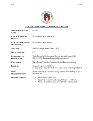
ITEM FOR ENVIRONMENTAL COMMISSION AGENDA COMMISSION MEETING DATE: 9/7/2022 NAME & NUMBER OF PROJECT: NAME OF APPLICANT OR ORGANIZATION: BKO Parmer (SP-2021-0034D) BKO Parmer (Steve Jamison) LOCATION: 4801 East Yager, Austin, Texas 78754 COUNCIL DISTRICT: ETJ ENVIRONMENTAL REVIEW STAFF: Tunde Daramola, Environmental Review Specialist Senior, DSD, 512-974-6316, Babatunde.Daramola@austintexas.gov WATERSHED: REQUEST: STAFF RECOMMENDATION: STAFF CONDITIONS: Harris Branch Watershed, Suburban, Desired Development Zone Variance request is as follows: Request to vary from LDC 25-8-342 to allow fill over 4feet up to 12feet. Staff recommends this variance, having determined the findings of fact to have been met. Preserve trees/natural areas. Apply City of Austin Landscaping Ordinance on ETJ site. Provide structural containment of fill with a retaining wall. 1 of 74B-8 Development Services Department Staff Recommendations Concerning Required Findings Project Name: Ordinance Standard: Watershed Protection Ordinance Variance Request: BKO Parmer To allow for fill exceeding 4 feet up to 12 feet for building construction Include an explanation with each applicable finding of fact. A. Land Use Commission variance determinations from Chapter 25-8-41 of the City Code: 1. The requirement will deprive the applicant of a privilege available to owners of similarly situated property with approximately contemporaneous development subject to similar code requirements. Yes. The variance will not be providing a special privilege to the applicant. The proposed buildings are similar in size to similarly situated property. In order to facilitate this type of development levelling and additional fill is required for the buildings. Prior projects in this area had a similar situation. A prime example is Crossroad Logistics Center Additions, SP-2021-0169D. A Land Use Commission variance was granted to LDC 25-8-342 to allow fill up to 17 feet. 2. The variance: a) Is not necessitated by the scale, layout, construction method, or other design decision made by the applicant, unless the design decision provides greater overall environmental protection than is achievable without the variance; Yes. Existing site conditions necessitate additional “fill” for fulfilling the requirements of two fire lane/emergency access routes as well as structural bridge for spanning the CWQZ. b) Is the minimum deviation from the code requirement necessary to allow a reasonable use of the property; Yes. The site is being graded as efficiently as possible to provide the required access slopes and bridge heights to minimize the amount of variance required. 2 of 74B-8 c) Does not create a significant probability of harmful environmental consequences. The variance does not create a significant probability of harmful Yes. consequences. The variance is a minimum deviation from code to allow for reasonable use of the property. Fill will be minimized and structurally contained with a retaining wall. 3. Development with the variance will result in water quality that is at least equal to the water quality achievable without the variance. Yes. The project is served by four water quality/detention ponds. The development is compliant with current code. B. The Land Use Commission may grant a variance from a requirement of Section 25-8-422 (Water Supply Suburban Water Quality Transition Zone), Section 25-8-452 (Water Supply Rural Water Quality Transition Zone), Section 25-8-482 (Barton Springs Zone Water Quality Transition Zone), Section 25-8-368 (Restrictions on Development Impacting Lake Austin, Lady Bird Lake, and Lake Walter E. Long), or Article 7, Division 1 ( Critical Water Quality Zone Restrictions ), after determining that:: 1. 1. The criteria for granting a variance in Subsection (A) are met; N/A All criteria in Subsection (A) are met 2. 3. The requirement for which a variance is requested prevents a reasonable, economic use of the entire property; N/A The proposed development is consistent with applicable zoning and surrounding properties. The variance is the minimum deviation from the code requirement necessary to allow a reasonable, economic use of the entire property. N/A The site is being graded as efficiently as possible to provide the required slopes and bridge heights. Staff Determination: Staff determines that the findings of fact have been met. Staff recommends the following conditions per approved exhibit: Preserve trees/natural areas. Apply City of Austin Landscaping Ordinance on ETJ site. Provide structural containment of fill with a retaining wall. 3 of 74B-8 Environmental Reviewer (DSD) Tunde Daramola Environmental Review Manager (DSD) _____________________________ Mike McDougal Deputy Environmental Officer (WPD) _____________________________ Liz Johnston Date 8/19/2022 Date 8/21/ /2022 Date 08/25 /2022 4 of 74B-8 ENVIRONMENTAL COMMISSION VARIANCE APPLICATION FORM August 05, 2022 Denise Lucas, Director Development Services Department City of Austin P.O. Box 1088 Austin, Texas 78767 RE: Fill Variance Request Letter BKO Parmer 4801 East Yager Lane SP-2021-0034D LDC 25-8-342 Fill Requirements Dear Ms. Lucas: On behalf of the owner, we are requesting a variance for fill in excess of four (4) feet for the proposed development of the BKO Parmer site development permit (SP-2021-0034D) located at 4801 East Yager Lane. The subject project is located in the 2-mile Extraterritorial Jurisdiction (ETJ). The property is currently undeveloped and is located at the southwest corner of the intersection of East Parmer Lane and East Yager Lane. City of Austin | Environmental Commission Variance Application Guide 1 5 of 74B-8 August 05, 2022 This project proposes the construction of apartments, a hotel and a convenience store, with four (4) water quality / detention ponds, six driveways and all associated grading, paving, water, wastewater, and drainage improvements. The applicant proposes to place new improvements on the property in a manner to minimize adverse impacts to the natural character of the property. The site is in the Harris Branch Watershed, which is a Suburban Watershed. The subject tract is not located over the Edwards Aquifer Recharge Zone. City of Austin | Environmental Commission Variance Application Guide 2 6 of 74B-8 August 05, 2022 With regard to the proposed variance, we respectfully suggest the following conditions be considered: 1. Preservation of trees and/or natural areas not already required to be preserved in the ETJ: o Trees Saved 787 trees = 10,693 inches 2. Apply City of Austin Landscaping Ordinance on this ETJ site: o Added 118 Street Yard Trees (118 Trees Required) = (177 inches added) o Added 174 Landscape Islands/Medians/Peninsulas Trees = (261 inches added) o Total Trees Added = 292 Trees = (438 inches added) 3. Added retaining walls (1,375 lf) to contain the major fill areas. The project requires leniency from the following code section: Division 5. ‐ Cut, Fill, and Spoil. § 25-8‐342 ‐ FILL REQUIREMENTS. (A) Fill on a tract of land may not exceed four feet of depth, except: (1) in an urban watershed; (2) in a roadway right‐of‐way; (3) under a foundation with sides perpendicular to the ground, or with pier and beam construction; (4) for construction of a water quality control or detention facility and appurtenances for conveyance such as swales, drainage ditches, and diversion berms, if: the fill is the minimum necessary for the appropriate functioning of the design and location of the facility within the site minimize the (a) amount of fill over four feet; (b) the facility; and (c) 15 percent or within 100 feet of a classified waterway; the fill is not located on a slope with a gradient of more than (5) for utility construction or a wastewater drain field; or (6) in a state‐permitted sanitary located landfill in the extraterritorial jurisdiction, if: floodplain; (a) the fill is derived from the landfill operation; (b) the fill is not placed in a critical water quality zone or a 100‐year the landfill operation has an erosion and restoration plan (c) approved by the single office; and (d) all other applicable City Code and County Code provisions are met. Fill for a roadway must be contained within the roadway clearing width (B) A fill area must be restored and stabilized. (C) described in Section 25-8‐322 (Clearing For A Roadway). City of Austin | Environmental Commission Variance Application Guide 3 7 of 74B-8 August 05, 2022 The Land Development Code allows Land Use Commission Variances per the following: It is the applicant's burden to establish that the findings described in this Division 3. ‐ Variances. § 25‐8‐41 ‐ LAND USE COMMISSION VARIANCES (A) Section have been met. Except as provided in Subsections (B) and (C), the land use commission may grant a variance from a requirement of this subchapter after determining that: (1) to owners of other similarly situated property with approximately contemporaneous development subject to similar code requirements; (2) the requirement will deprive the applicant of a privilege available is not necessitated by the scale, layout, construction method, the variance: (a) or other design decision made by the applicant, unless the design decision provides greater overall environmental protection than is achievable without the variance; (b) necessary to allow a reasonable use of the property; and (c) environmental consequences; and development with the variance will result in water quality that is at least is the minimum deviation from the code requirement does not create a significant probability of harmful (3) equal to the water quality achievable without the variance. The findings of fact concerning the need for the variance are outlined below. We respectfully seek your consideration and support of this variance request. If you have any questions, please feel free to call our office at (737) 484-0880. Stephen R. Jamison, P.E. Jamison Civil Engineering LLC (TBPE Firm #F-17756) City of Austin | Environmental Commission Variance Application Guide 4 08/05/20228 of 74B-8 Stephen R. Jamison P.E., Jamison Civil Engineering, LLC June 29, 2022 PROJECT DESCRIPTION Applicant Contact Information Name of Applicant Street Address 13812 Research Blvd. #B-2 City State ZIP Code Austin, Texas 78750 Work Phone E-Mail Address Case Name Case Number Variance Case Information 737-484-0880 steve@jamisoneng.com BKO Parmer SP-2021-0034D Address or Location 4801 East Yager Lane Environmental Reviewer Name Environmental Resource Management Reviewer Name Applicable Ordinance Tunde Daramola Current Code Watershed Name Harris Branch Creek Watershed Classification Edwards Aquifer Recharge Zone ☐Urban ☐ Suburban ☐Water Supply Suburban ☐Water Supply Rural ☐ Barton Springs Zone ☐ Barton Springs Segment ☐ Northern Edwards Segment ☐ Not in Edwards Aquifer Zones Edwards Aquifer Contributing Zone Distance to Nearest Classified Waterway Water and Waste Water service to be provided by ☐ Yes ☐ No +/- 0 feet to Harris Branch Creek (Intermediate) – on site +/- 0 feet to Harris Branch Creek (Minor) – on site Austin Water Utility City of Austin | Environmental Commission Variance Application Guide 5 9 of 74B-8 June 29, 2022 Request Impervious cover Square Footage: Acreage: Percentage: Provide general description of the property (slope range, elevation range, summary of vegetation / trees, summary of the geology, CWQZ, WQTZ, CEFs, floodplain, heritage trees, any other notable or outstanding characteristics of the property) The variance request is as follows (Cite code references): LDC 25-8-342 Fill Requirements (12.0 feet max.) Existing 5,060 sf 0.12 ac. 0.1% Proposed 1,237,287 sf 28.40 ac. 33.9% The property has slopes that vary from 0% to 15%. The slope breakdown is as follows: 0-15% Slopes ---> 81.34 acres 15-25% Slopes ---> 1.81 acres 25-35% Slopes ---> 0.34 acres Over 35% Slopes ---> 0.26 acres The elevation ranges from a low point of 584.0’ to a high point of 635.0’. The majority of the ground vegetation is typical hill country grasses/prairie/woods in good condition. The majority of the existing soils consists of soils ranging from Ferris-Heiden Complex, Heiden Clay and Houston Black Clay, (all Class D Hydrologic Group) A portion of the property contains CWQZ and Wetland CEFs. A portion of this site is located within the fully developed 4% & 1% Annual Chance Flood Plain (25-Year & 100-Year). The plan complies with all current codes. Clearly indicate in what way the proposed project does not comply with current Code (include maps and exhibits) City of Austin | Environmental Commission Variance Application Guide 6 10 of 74B-8 June 29, 2022 FINDINGS OF FACT Ordinance: A. 1. 2. As required in LDC Section 25-8-41, in order to grant a variance, the Land Use Commission must make the following findings of fact. Included below is an explanation alongside each applicable finding of fact. Land Use Commission variance determinations from Chapter 25-8-41 of the City Code: The requirement will deprive the applicant of a privilege available to owners of similarly situated property with approximately contemporaneous development subject to similar code requirements. Yes Nearby projects have been granted similar variances: Applied Materials Logistics Service Center (LI-PDA Ordinance 20201210-071), Crossroads Logistics Center (SP-2021-0015D), and Crossroads Logistics Center Additions (SP-2021-0169D). (SP-2020-0321C), Samsung The variance: a) Is not necessitated by the scale, layout, construction method, or other design decision made by the applicant, unless the design decision provides greater overall environmental protection than is achievable without the variance; Yes b) Yes c) Yes The site conditions necessitate additional fill for providing: a. The requirement to provide two (2) fire lane / emergency access routes b. The structural bridge required for spanning the CWQZ / 100-year flood throughout the project. plain. c. The required structural bridge elevation/clearance to maintain the minimum height above the fully developed 100-year flood plain water surface elevation. Is the minimum deviation from the code requirement necessary to allow a reasonable use of the property; The site is being graded as efficiently as possible to provide the required access slopes and bridge heights – to minimize amount of variance needed as possible. Does not create a significant probability of harmful environmental consequences. No harmful environmental consequences the variance. Additionally, conditions are proposed to further protect the environment including preserving natural areas, planting additional trees/landscaping, and revegetation of site. result from City of Austin | Environmental Commission Variance Application Guide 7 11 of 74B-8 June 29, 2022 Development with the variance will result in water quality that is at least equal to the water quality achievable without the variance. Yes The development is compliant with current code and will meet all water quality regulations. 3. **Variance approval requires all above affirmative findings. City of Austin | Environmental Commission Variance Application Guide 8 12 of 74B-8 June 29, 2022 A Exhibits for Commission Variance o Aerial photos of the site o Site photos o Aerial photos of the vicinity o Context Map—A map illustrating the subject property in relation to developments in the vicinity to include nearby major streets and waterways o Topographic Map - A topographic map is recommended if a significant grade change on the subject site exists or if there is a significant difference in grade in relation to adjacent properties. o For cut/fill variances, a plan sheet showing areas and depth of cut/fill with topographic elevations. o Site plan showing existing conditions if development exists currently on the property o Proposed Site Plan- full size electronic or at least legible 11x17 showing proposed development, include tree survey if required as part of site or subdivision plan o Environmental Map – A map that shows pertinent features including Floodplain, CWQZ, WQTZ, CEFs, Setbacks, Recharge Zone, etc. o An Environmental Resource Inventory pursuant to ECM 1.3.0 (if required by 25-8-121) o Applicant’s variance request letter City of Austin | Environmental Commission Variance Application Guide 9 13 of 74B-8 BKO PARMER ➤➤ N N 1000 ft 14 of 74B-8 TOPO SOURCE: DESIGN SURVEY DATE OF SURVEY: AUGUST 2020 *THIS SHEET IS FOR CUT AND FILL EXHIBIT PURPOSES ONLY. SEE OTHER SHEETS FOR ALL EXISTING AND PROPOSED UTILITY LINE LOCATIONS. **PRESERVATION OF TREES AND/OR NATURAL AREAS NOT ALREADY REQUIRED TO BE PRESERVED IN THE ETJ: TREES SAVED 787 TREES = 10,693 INCHES MAXIMUM FILL = 12.0 FEET C I T Y O F A U S T I N A U S T I N 2 - M I L E E T J WQ & DETENTION POND 'C' N O P A R K I N G WQ & DETENTION POND 'B' CITY OF AUSTIN AUSTIN 2-MILE ETJ SLIDING GATE WQ & DETENTION POND 'A' SLIDING GATE SLIDING GATE N O P A R K I N G GRASSPAVE S L I D I N G G A T E S L I D I N G G A T E S L I D I N G G A T E S L I D I N G G A T E WQ & DETENTION POND 'D' S L I D I N G G A T E E C J ) 6 5 7 7 1 - F # . G E R M R F E P I . X T ( 2 - B # . D V L B H C R A E S E R 2 1 8 3 1 0 5 7 8 7 S A X E T , I N T S U A 0 8 8 0 - 4 8 4 ) 7 3 7 ( : I E C F F O . M O C G N E N O S M A J @ O F N I I I C L L G N I R E E N G N E L I V I C N O S I M A J R E M R A P O K B I I T B H X E L L I F T U C S A X E T , I N T S U A E N A L R E M R A P T S A 1 0 8 4 L L I F T U C : t o h s p a n S g w d . L L I F T U C S N A L P G W D \ \ \ r e m r a P O K B \ : J R S : y B n w a r D J R S : y B d e k c e h C 1 2 / 5 0 2 0 / : e t a D : ) . t r e V l ( e a c S ' 0 0 1 = 1 : : ) . r o H ( l e a c S CAUTION!!! CONTRACTOR SHALL LOCATE ANY/ALL EXISTING UTILITIES PRIOR TO ANY SITE WORK, (BOTH HORIZONTALLY AND VERTICALLY). THE DESIGN ENGINEER WILL NOT BE RESPONSIBLE FOR DAMAGES TO ANY EXISTING UTILITIES OR FOR ANY CONFLICTS THAT MAY ARISE DUE TO ANY UTILITIES NOT PROPERLY LOCATED. . o N b o J H : e l i F : i 1 n o s v e R i : i 2 n o s v e R i : i 3 n o s v e R i : i 4 n o s v e R i SHEET of 36 165 SP-2021-0034D 4801 EAST YAGER LANE15 of 74B-8 TOPO SOURCE: DESIGN SURVEY DATE OF SURVEY: AUGUST 2020 B U I L D I N G # 5 T Y P E 1 1 7 , 1 9 0 S F . S L A B O N G R A D E F F E = 6 3 1 . 1 N O P A R K I N G D D F F E = 6 2 9 . 1 B U I L D I N G # 4 T Y P E 2 1 8 , 3 3 0 S F . S L A B O N G R A D E WQ & DETENTION POND 'C' G A R A G E 1 9 F F E = 6 3 1 . 1 B U I L D I N G # 6 T Y P E 1 1 7 , 1 9 0 S F . S L A B O N G R A D E D D G A R A G E 1 8 G A R A G E 1 7 F F E = 6 3 0 . 6 B U I L D I N G # 7 T Y P E 1 1 7 , 1 9 0 S F . S L A B O N G R A D E F F E = 6 2 5 . 6 B U I L D I N G # 8 T Y P E 1 1 7 , 1 9 0 S F . S L A B O N G R A D E D D G A R A G E G 1 6 G A R A G E G 1 5 FFE=619.5 436S 4 - STORY APARTMENT 34,160 SF 60' HT. SLAB ON GRADE F POOL P NO PARKING NO PARKING N O P A R K I N G F F E = 6 1 9 . 5 1 5 , PB1F 8 1 0 S F B U I L D I N G # 3 P A R K I N G G A R A G E S L A B O N G R A D E 6 0 ' H T . 416S 1 7 , 7 2 0 S F F 4 - S T O R Y A P A R T M E N T F F E = 6 1 8 . 1 NO PARKING NO PARKING G A R A G E G 1 4 G A R A G E G 1 3 GARAGE 12 G GARAGE 11 G N O P A R K I N G PB1F PARKING GARAGE BUILDING #4 17,780 SF FFE=618.1 G GARAGE 10 GARAGE 9 G WQ & DETENTION POND 'B' GARAGE 20 BUILDING #9 TYPE 1 17,190 SF. SLAB ON GRADE FFE=628.1 POOL C L U B B H S L A F B F O UIL 4 , 8 O U S DIN 8 0 S G E N G = 6 3 R F . A 5 . 6 D E E/O # 1 3 F FIC E S L I D I N G G A T E G N I K R A P O N NO PARKING S L I D I N G G A T E F F E = 6 3 5 . 6 B U I L D I N G # 1 2 T Y P E 1 1 7 , 1 9 0 S F . S L A B O N G R A D E S L I D I N G G A T E GARAGE 21 BUILDING #10 TYPE 1 17,190 SF. SLAB ON GRADE FFE=628.1 D D D D WQ & DETENTION POND 'D' B U I L D I N G # 1 1 T Y P E 1 1 7 , 1 9 0 S F . S L A B O N G R A D E F F E = 6 3 2 . 6 S L I D I N G G A T E P R O P O S E D 4 - S T O R Y A P A R T M E N T B U I L D I N G 8 3 , 4 0 0 S F . S L A B O N G R A D E F F E = 6 3 7 . 6 N O P A R K I N G N O P A R K I N G S L I D I N G G A T E G 7 E G A R A G G 8 E G A R A G 6 E G A R A G G WQ & DETENTION POND 'A' NO PARKING NO PARKING I E G A R A G G N K R A P Y R O T S - 1 T N E M T R A P A Y R O T S - 4 426S F S 6 6 7 , F 5 4 . T H ' 0 6 E D A R G N O B A L S 6 . 9 2 6 = E F F 1 E G A R A G 2 E G A R A G G 3 E G A R A G G I G N K R A P O N I G N K R A P O N B L D G 1 A FITNESS 2,800 SF POOL 2,400 SF PB2F 4 - STORY APARTMENT/ 1-STORY PARKING GARAGE 37,079 SF 60' HT. SLAB ON GRADE 416S F FFE=622.6 GARAGE 5 G GARAGE 4 G NO PARKING NO PARKING 417S 4 - STORY HOTEL 16,250 SF 75' HT. SLAB ON GRADE F FF=610.3 POOL P E R O T S E C N E N E V N O C I . F S 0 2 6 C7SF , 7 E D A R G N O B A L S 6 . 0 1 6 = F F O N I G N K R A P E C J ) 6 5 7 7 1 - F # . G E R M R F E P I . X T ( 2 - B # . D V L B H C R A E S E R 2 1 8 3 1 0 5 7 8 7 S A X E T , I N T S U A 0 8 8 0 - 4 8 4 ) 7 3 7 ( : I E C F F O . M O C G N E N O S M A J @ O F N I I I C L L G N I R E E N G N E L I V I C N O S I M A J R E M R A P O K B T B I I H X E E E R T D E V A S E N A L R E M R A P T S A E 1 0 8 4 S A X E T , I N T S U A L L A R E V O : t o h s p a n S P S D : y B n w a r D J R S : y B d e k c e h C 1 2 / 5 0 2 0 / : e t a D : ) . t r e V l ( e a c S ' 0 0 1 = 1 : : ) . r o H ( l e a c S **PRESERVATION OF TREES AND/OR NATURAL AREAS NOT ALREADY REQUIRED TO BE PRESERVED IN THE ETJ: TREES SAVED 787 TREES = 10,693 INCHES CAUTION!!! CONTRACTOR SHALL LOCATE ANY/ALL EXISTING UTILITIES PRIOR TO ANY SITE WORK, (BOTH HORIZONTALLY AND VERTICALLY). THE DESIGN ENGINEER WILL NOT BE RESPONSIBLE FOR DAMAGES TO ANY EXISTING UTILITIES OR FOR ANY CONFLICTS THAT MAY ARISE DUE TO ANY UTILITIES NOT PROPERLY LOCATED. . o N b o J : e l i F : i 1 n o s v e R i : i 2 n o s v e R i : i 3 n o s v e R i : i 4 n o s v e R i SHEET of 08 165 SP-2021-0034D 4801 EAST YAGER LANE16 of 74B-8 E C J ) 6 5 7 7 1 - F # . G E R M R F E P I . X T ( 2 - B # . D V L B H C R A E S E R 2 1 8 3 1 0 5 7 8 7 S A X E T , I N T S U A 0 8 8 0 - 4 8 4 ) 7 3 7 ( : I E C F F O . M O C G N E N O S M A J @ O F N I I I C L L G N I R E E N G N E L I V I C N O S I M A J R E M R A P O K B D E V A S - T S I L E E R T E N A L R E M R A P T S A E 1 0 8 4 S A X E T , I N T S U A I N O S O R E : t o h s p a n S P S D : y B n w a r D J R S : y B d e k c e h C 1 2 / 5 0 2 0 / : e t a D : ) . t r e V l ( e a c S ' 0 4 = 1 : : ) . r o H l ( e a c S **PRESERVATION OF TREES AND/OR NATURAL AREAS NOT ALREADY REQUIRED TO BE PRESERVED IN THE ETJ: TREES SAVED 787 TREES = 10,693 INCHES CAUTION!!! CONTRACTOR SHALL LOCATE ANY/ALL EXISTING UTILITIES PRIOR TO ANY SITE WORK, (BOTH HORIZONTALLY AND VERTICALLY). THE DESIGN ENGINEER WILL NOT BE RESPONSIBLE FOR DAMAGES TO ANY EXISTING UTILITIES OR FOR ANY CONFLICTS THAT MAY ARISE DUE TO ANY UTILITIES NOT PROPERLY LOCATED. . o N b o J : e l i F : i 1 n o s v e R i : i 2 n o s v e R i : i 3 n o s v e R i : i 4 n o s v e R i SHEET of 17 165 SP-2021-0034D 4801 EAST YAGER LANE17 of 74B-8