03 C14-2022-0067 - Villas at South Austin; District 2.pdf — original pdf
Backup
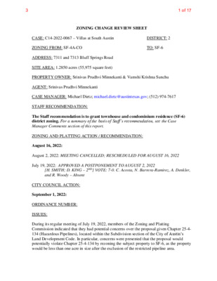
ZONING CHANGE REVIEW SHEET DISTRICT: 2 TO: SF-6 CASE: C14-2022-0067 – Villas at South Austin ZONING FROM: SF-4A-CO ADDRESS: 7311 and 7313 Bluff Springs Road SITE AREA: 1.2850 acres (55,975 square feet) PROPERTY OWNER: Srinivas Prudhvi Minnekanti & Vamshi Krishna Sunchu AGENT: Srinivas Prudhvi Minnekanti CASE MANAGER: Michael Dietz; michael.dietz@austintexas.gov; (512) 974-7617 STAFF RECOMMENDATION: The Staff recommendation is to grant townhouse and condominium residence (SF-6) district zoning. For a summary of the basis of Staff’s recommendation, see the Case Manager Comments section of this report. ZONING AND PLATTING ACTION / RECOMMENDATION: August 16, 2022: August 2, 2022: MEETING CANCELLED; RESCHEDULED FOR AUGUST 16, 2022 July 19, 2022: APPROVED A POSTPONEMENT TO AUGUST 2, 2022 [H. SMITH; D. KING – 2ND] VOTE: 7-0. C. Acosta, N. Barrera-Ramirez, A. Denkler, and R. Woody – Absent CITY COUNCIL ACTION: September 1, 2022: ORDINANCE NUMBER: ISSUES: During its regular meeting of July 19, 2022, members of the Zoning and Platting Commission indicated that they had potential concerns over the proposal given Chapter 25-4- 134 (Hazardous Pipelines), located within the Subdivision section of the City of Austin’s Land Development Code. In particular, concerns were presented that the proposal would potentially violate Chapter 25-4-134 by rezoning the subject property to SF-6, as the property would be less than one acre in size after the exclusion of the restricted pipeline area. 31 of 17 C14-2022-0067 Page 2 Staff was able to confirm that LDC Chapter 25-4-134 only applies to proposed subdivisions within the city limits. The proposal does not include a subdivision of the property, and the applicant has indicated that they do not intend to resubdivide the property in order to construct the seven units intended for the site. Furthermore, the existing property is a platted lot; the subdivision plat (C8-2016-0002.0A) has been included with the backup to this report. As such, the subject site was originally subdivided in 2016, but the code section in question was adopted in 2003. Staff was unable to find any subsequent notations or variances to LDC Chapter 25-4-134; therefore, it seems that the subdivision was approved in accordance with the adopted code in effect at 2016, which would have included LDC Chapter 25-4-134. Members of the Commission also indicated that they had concerns over potentially rezoning the property from SF-4A-CO to SF-6, as this would remove the conditional overlay currently in effect that restricts cumulative vehicle trips in the area to 2,000 per day or less. The application was reviewed by ATD for potential traffic impacts. In total, the proposal to develop seven detached condominium units would generate an estimated 87 vehicle trips per day. If the site were further redeveloped to the maximum density allowed under the SF-6 district at some point in the future (15 units), it could generate up to approximately 143 trips per day. The previous zoning case that established the existing conditional overlay has been fully developed with 135 residential units, totaling an estimated 1,330 cumulative vehicular trips per day. As such, ATD noted that “a vehicle trip restriction in this instance is not productive” and recommended that the application proceed without applying the existing conditional overlay. It should also be noted that there is precedence for removing similar conditional overlays as part of rezoning applications for other properties where the same cumulative vehicle trip restriction was applied. The proposed rezoning has been reviewed by ATD for potential traffic impacts, and any future development of the seven residential units sought by the applicant would be subject to further review by ATD. As such, staff believes that the removal of the conditional overlay as part of the proposed rezoning would be warranted. CASE MANAGER COMMENTS: The subject rezoning area consists of one platted lot, which is located near the intersection of Bluff Springs Road and Tranquilo Trail and is currently zoned as single family – small lot – conditional overlay (SF-4A-CO) district (C14-98-0224 – Ordinance No. 990506-65). The Conditional Overlay serves to restrict the project site and all other existing and previously authorized uses within the combining district to a maximum cumulative total of 2,000 vehicular trips per day and also to prohibit vehicular access from the subject property to Dakota Lane. It should also be noted that a Longhorn Pipeline gas easement is recorded over the subject property, as verified by the submitted survey. The easement requires a 50-foot building setback from the gas lines and additional building construction and design standards may be required for the proposed residential units, including the installation of fire sprinklers, a restriction on the proposed locations of windows, and limitations on construction materials designed to ensure that fire-resistive materials are used. 32 of 17 C14-2022-0067 Page 3 The subject site is mostly triangular in shape and is currently undeveloped. Bluff Springs Road primarily features residential uses of varying densities. There are apartments to the west of the site (CS-MU-CO), single-family residences to the north and east (SF-4A-CO), and an automotive repair use to the south (I-RR). Please refer to Exhibits A (Zoning Map) and A-1 (Aerial Exhibit). The applicant has requested townhouse & condominium (SF-6) district zoning. The application indicates that the applicant intends to construct seven residential units on the property. The SF-6 district does not establish a maximum density or floor area ratio for each lot. However, the district does identify a maximum building height of 35 feet and a maximum building coverage of 40%. The requested SF-6 zoning designation would allow for the clustering of the proposed units, given the irregular shape of the property and the gas line along the northern property line. The clustered units would allow for more flexibility with the potential design and the maximization of common open space on-site. BASIS OF RECOMMENDATION: 1. The proposed zoning should be consistent with the purpose statement of the district sought. Zoning changes should promote compatibility with adjacent and nearby uses. The townhouse & condominium (SF-6) district is the designation for a moderate density single-family residential, duplex, two-family, townhouse, or condominium use on a lot that is a minimum of 5,750 square feet. An SF-6 district designation may be applied to a use in an existing single-family or smaller multi-family residential neighborhood with moderately sized lots or to new development with lots that are 5,750 square feet or more. The SF-6 zoning designation is appropriate in areas where a transition from single-family to multi- family residential uses is desirable. The proposal would be consistent with the purpose statement of the SF-6 zoning district. 2. The requested SF-6 zoning would allow for the potential future construction of a variety of residential uses on-site. Staff recommends approval of the applicant’s request because the location is appropriate for a transitional zone between the higher-density residential use to the west, the industrial use to the south, and the single-family residential uses to the north and east. Furthermore, the subject property is of sufficient size to benefit from the SF-6 designation. Public transit options in the area are limited at this time, with only one established bus route accessible at the intersection of Bluff Springs Road and Blue Meadow Drive. However, CapMetro’s Connections 2025 Transit Plan indicates that another bus line to serve the area has been proposed. As such, the proposal would be compatible with the adjacent and nearby uses. 33 of 17 C14-2022-0067 Page 4 EXISTING ZONING AND LAND USES: ZONING SF-4A I-RR SF-4A-CO Site South North/ East West LAND USES Undeveloped Automotive repair Single-family residences CS-MU-CO Apartment buildings SCENIC ROADWAY: No NEIGHBORHOOD PLANNING AREA: None TIA: Not Required WATERSHED: South Boggy Creek Watershed – Suburban & Onion Creek Watershed – Suburban CAPITOL VIEW CORRIDOR: No SCHOOLS: Langford Elementary School Mendez Middle School Akins High School COMMUNITY REGISTRY LIST: 511 – Austin Neighborhoods Council 627 – Onion Creek HOA 742 – Austin Independent School District 1228 – Sierra Club, Austin Regional Group 1249 – Los Jardines Homeowners Association 1258 – Del Valle Community Coalition 1363 – SEL Texas 1408 – Go!Austin/Vamos!/Austin (GAVA) – 78744 1431 – Indian Hills Neighborhood Watch 1441 – Dove Springs Proud 1530 – Friends of Austin Neighborhoods 1550 – Homeless Neighborhood Association 1616 – Neighborhood Empowerment Foundation 1774 – Austin Lost and Found Pets AREA CASE HISTORIES: REQUEST COMMISSION SF-4A-CO To Grant CITY COUNCIL Apvd (12-15-2015). NUMBER C14-2014-0189 – 2015 Tranquilo Trail 34 of 17 C14-2022-0067 Page 5 C14-2008-0123 – 7309 S IH 35 Service Rd. NB GR; I-RR to MF-3; CS C14-2019-0020 – Little Texas MHC I-RR to MH C14-2013-0060 – 7101 Bluff Springs Rd. LR-CO to LR-CO to revise Conditional Overlay To Grant with conditions of the TIA and with additional prohibited uses To Forward to Council without a recommendation due to lack of an affirmative vote To Grant Apvd as Commission recommended (03-11- 2010). Apvd (06-06-2019). Apvd (11-21-2013). RELATED CASES: The property was annexed into the City limits in December 1994 (C7A-94-011, Ord. 940908-N). The property is platted as Lot 12, Block C, of the Amended Plat of Lot 12, Block C, of Meadows at Bluff Springs, Document Number 201600088. EXISTING STREET CHARACTERISTICS: Name ASMP Classification Existing ROW Existing Pavement Sidewalks Bicycle Route ASMP Required ROW Capital Metro (within ¼ mile) Yes 120’ 110’ 48’ No Shared Lane 3 Bluff Springs Road OTHER STAFF COMMENTS: Inclusive Planning Yes Imagine Austin Decision Guidelines Compact and Connected Measures Imagine Austin Growth Concept Map: Located close to, within or adjacent to an Imagine Austin Activity Center, Imagine Austin Activity Corridor, or Imagine Austin Job Center as identified on the Growth Concept Map. Name(s) of Activity Center/Activity Corridor/Job Center: Y Mobility and Public Transit: Located within 0.25 miles of public transit stop and/or light rail station. 35 of 17 C14-2022-0067 Page 6 Y Mobility and Bike/Ped Access: Adjoins a public sidewalk, shared path, and/or bike lane (across the street) Connectivity, Good and Services, Employment: Provides or is located within 0.50 miles to goods and services, and/or employment center. Connectivity and Food Access: Provides or is located within 0.50 miles of a grocery store/farmers market. Connectivity and Education: Is located within 0.50 miles from a public school or university. Connectivity and Healthy Living: Provides or is located within 0.50 miles from a recreational area, park or walking trail. Connectivity and Health: Provides or is located within 0.50 miles of health facility (ex: hospital, urgent care, doctor’s office, drugstore clinic, specialized outpatient care.) Housing Affordability: Provides a minimum of 10% of units for workforce housing (80% MFI or less) and/or fee in lieu for affordable housing. Y Housing Choice: Expands the number of units and housing choice that suits a variety of household sizes, incomes, and lifestyle needs of a diverse population (ex: apartments, triplex, granny flat, live/work units, cottage homes, and townhomes) in support of Imagine Austin and the Strategic Housing Blueprint. Mixed Use: Provides mixed use development (minimum 10% residential and 10% non-residential floor area). Culture and Creative Economy: Provides or is located within 0.50 miles of a cultural resource (ex: library, theater, museum, cultural center). Total Number of “Yes’s” 3 Drainage The applicant would be required to submit a pre- and post-development drainage analysis at the subdivision and site plan stage of the development process. The City’s Land Development Code and Drainage Criteria Manual require that the applicant demonstrate through engineering analysis that the proposed development will have no identifiable adverse impact on surrounding properties. Environmental The site is not located over the Edwards Aquifer Recharge Zone. The site is in the South Boggy Creek Watershed and the Onion Creek Watershed, of the Colorado River Basin, which are classified as a Suburban Watersheds by Chapter 25-8 of the City's Land Development Code. The site is in the Desired Development Zone. Under current watershed regulations, development or redevelopment on this site will be subject to the following impervious cover limits: 36 of 17 C14-2022-0067 Page 7 Development Classification % of Gross Site Area % of Gross Site Area Single-Family (minimum lot size 5750 sq. ft.) Other Single-Family or Duplex Multifamily Commercial 50% 55% 60% 80% with Transfers 60% 60% 70% 90% According to floodplain maps there is no floodplain within or adjacent to the project location. Standard landscaping and tree protection will be required in accordance with LDC 25-2 and 25-8 for all development and/or redevelopment. At this time, site specific information is unavailable regarding vegetation, areas of steep slope, or other environmental features such as bluffs, springs, canyon rimrock, caves, sinkholes, and wetlands. Under current watershed regulations, development or redevelopment requires water quality control with increased capture volume and control of the two-year storm on site. Parks & Recreation Department (PARD) – Planning & Design Review Parkland dedication will be required for the new applicable uses proposed by this development, single family with SF-6 zoning, at the time of subdivision or site plan, per City Code § 25-1-601. Whether the requirement shall be met with fees in-lieu or dedicated land will be determined using the criteria in City Code Title 25, Article 14, as amended. Should fees in-lieu be required, those fees shall be used toward park investments in the form of land acquisition and/or park amenities within the surrounding area, per the Parkland Dedication Operating Procedures § 14.3.11 and City Code § 25-1-607 (B)(1) & (2). If the applicant wishes to discuss parkland dedication requirements in advance of site plan or subdivision applications, please contact this reviewer: thomas.rowlinson@austintexas.gov. At the applicant’s request, PARD can provide an early determination of whether fees in-lieu of land will be allowed. Site Plan and Compatibility Standards Site plans will be required for any new development other than single-family, two-family, or duplex residential. Any development which occurs in an SF-6 or less restrictive zoning district which is located 540-feet or less from property in an SF-5 or more restrictive zoning district will be subject to compatibility development regulations. The site is subject to compatibility standards due to the adjacent SF-4A-CO district to the north. 37 of 17 C14-2022-0067 Page 8 Any new development is subject to Subchapter E. Design Standards and Mixed Use. Additional comments will be made when the site plan is submitted. This site will be subject to the condominium density provisions in 25-2-559 (Urban Family Residence (SF-5) District or Townhouse and Condominium Residence (SF-6) District Retirement Housing Use). Transportation The Austin Strategic Mobility Plan (ASMP) calls for 120 feet of right-of-way for Bluff Springs Road. It is recommended that 10 feet of right-of-way from the existing centerline should be dedicated for Bluff Springs Road according to the Transportation Plan with the first subdivision or site plan application [LDC 25-6-51 and 25-6-55]. Assessment of required transportation mitigation, including the potential dedication of right of way and easements and participation in roadway and other multi-modal improvements, will occur at the time of site plan application. A traffic impact analysis shall be required at the time of site plan if triggered per LDC 25-6-113. Austin Water Utility The landowner intends to serve the site with City of Austin water and wastewater utilities. The landowner, at own expense, will be responsible for providing any water and wastewater utility improvements, offsite main extensions, utility relocations and or abandonments required by the land use. The water and wastewater utility plan must be reviewed and approved by Austin Water for compliance with City criteria and suitability for operation and maintenance. Based on current public infrastructure configurations, it appears that service extension requests (SER) will be required to provide service to this lot. For more information pertaining to the Service Extension Request process and submittal requirements contact the Austin Water SER team at ser@austintexas.gov. The landowner must pay the City inspection fee with the utility construction. The landowner must pay the tap and impact fee once the landowner makes an application for a City of Austin water and wastewater utility tap permit. INDEX OF EXHIBITS TO FOLLOW: A: Zoning Map A-1: Aerial Map A-2: Map Showing Gas Line Easement Final Subdivision Plat – C8-2016-0002.0A Commissioner Q&A 38 of 17 C14-93-0086 CS-CO SP97-0289C ADULT\ORIENTED\USE C14-2018-0069 86-327 I-RR APTS. C14-84-457(RCA) GR RV PARKING MF-1 84-457RC CAMPGROUND SF-3 D R S G N I R P S F F U L B 99-2089 CS-CO C14-2017-0022 C14-95-0181 C14-2011-0127 UNDEV 84-302 RV PARKING STORAGE WAREHOUSE (VACANT) CS-MU-CO C14-2008-0123 C7a01-017 SF-4A-CO I-RR AUTO REPAIR I-RR MH MH MH MH MH MH MH MH MH MH MH 83-340 SF-6 MH MH MH MH MH MH MH MH MH MH D E E R R U MH MH MH N D R MH MH MH MH M H MH MH = SF-3 MH MH MH MH MH MH MH MH MH MH MH MH MH MH MH M H MH MH MH MH MH MH MH MH MH MH MH M H MH MH MH MH MH N L M U G E C U R P S MH MH MH R K D E E R M C EL MH MH MH MH MH M H MH MH MH O A K M MH MH MH MH O T T E L N MH M H MH MH MH MH MH MH MH MH MH MH M H MH MH = SF-3 = MH M H MH M H BL U E M MH M H MH MH MH E A D O W D R MH SF-3 = = L R N T W A E D U L B SF-3 MH MH MH N O G A L E S T R L SF-4A-CO P-CO 93-0 0 48 SF-3 KENDRA PAGE PARK I-RR UNDEV LR-CO 98-0224 ( ( ( ( ( ( ( ( ( ( ( ( ( ESPINO CV ( ( ( ( ( ( S S A P E R G E L A SF-4A-CO ( ( ( ( ( ( ( ( ( ( ( ( ( ( ( ( ( ( ( ( ( ( ( ( ( C14-98-0224 98-0224 SOMBRA CV L R T O T N A C N E ( ! ! ! ! ! ( ( ! ! ( ( TRANQUILO TRL ( ( ( ( ! SF-4A-CO ! ! ! ! P C14-2014-0189 ( ! ! ( ! ! ! ! ! ! ! ! ! ! SF-4A-CO S S A P N A D ( SF-2 SF-2 ( ( S S A P N A D ( ( SF-2 ( ( ( ( ( ( ( ( ( ( ( ( ( V C S D E ( ( ( ( ( ( ( ( ( ( QUICKSILVER BLVD ( ( ( ( ( ( ( ( ( ( ( ( ( ( ( ( ( ( ( ( ( PATSY PKWY ( ( ( ( ( ( ( ( ( ( ( ( ( ( SF-2 JENIBETH LN ( ( ( ( MH C14-2019-0020 MH-CO MH-CO ZONING C14-2018-0069 2008-0123 UNDEV MF-4-CO C14-2008-0211 2008-0211 C7a-01-017 COUNTY I-RR ± SUBJECT TRACT ! ! ! ! ! ! PENDING CASE ZONING BOUNDARY ZONING CASE#: C14-2022-0067 This product is for informational purposes and may not have been prepared for or be suitable for legal, engineering, or surveying purposes. It does not represent an on-the-ground survey and represents only the approximate relative location of property boundaries. 1 " = 400 ' This product has been produced by the Housing and Planning Department for the sole purpose of geographic reference. No warranty is made by the City of Austin regarding specific accuracy or Created: 5/26/2022 39 of 17 MH N O G ALE S T RL SF-4A-CO C14-98-0224 98-0224 SF-4A-CO SOMBRA CV L R T O T N A C N E ( ( ( ( LR-CO ( ( ( ( ( D R S G N I R P S F F U L B ( ( ( ( ( ESPINO CV ( ( ( ( ( ( S S A P E R G E L A ( ( ( ( ( ( ( ( ( ( ( ( ( ( ( SF-4A-CO ( ( ( ( ( ( ! ( ( ( ( ! ! ! H15 ( ( ( ( ( SF-4A-CO ! ! C14-2022-0067 ! ! ! ! AUTO REPAIR ( ( ! ! ( ( ! ! ! ! ! ! ! ! ! ! C14-2014-0189 ! ! P SF-4A-CO TRANQUILO TRL S S A P N A D H14 I-RR SF-2 ( ( ( SF-2 ( S S A N P A D ( ( ( ( PATSY PKWY ( ( ( ( ( G15 CS-MU-CO C14-2008-0123 I-RR C14-2008-0211 G14 MF-4-CO ± 1 " = 200 ' SUBJECT TRACT ZONING BOUNDARY ! ! ! ! ! ! PENDING CASE CREEK BUFFER Villas at South Austin ZONING CASE#: LOCATION: SUBJECT AREA: GRID: MANAGER: C14-2022-0067 7311 & 7313 Bluff Springs Rd 1.28 Acres H14, H15 Wendy Rhoades This product has been produced by the Housing and Planning Department for the sole purpose of geographic reference. No warranty is made by the City of Austin regarding specific accuracy or completeness. Created: 6/7/2022 310 of 17 ( ( SF-4A-CO ( ( ( ( ( ( ( ( ( ( ( ( ( ( ( ( S S A P E R G E L A ( C14-98-0224 ( SF-4A-CO CS-MU-CO ! ! C14-2008-0123 ! ! ! ( ( ( TRANQUILO TRL ( ( ! SF-4A-CO ! ! ! ! ( ( ( ! ! ! ! P C14-2014-0189 ! ! ! ! ! ! ! I D R S G N R P S F F U L B ! ! ! AUTO REPAIR I-RR ± SUBJECT TRACT ! ! ! ! ! ! PENDING CASE ZONING ZONING CASE#: C14-2022-0067 ZONING BOUNDARY 50' GAS EASEMENT This product is for informational purposes and may not have been prepared for or be suitable for legal, engineering, or surveying purposes. It does not represent an on-the- ground survey and represents only the approximate relative location of property boundaries. 1 " = 100 ' This product has been produced by the Housing and Planning Department for the sole purpose of geographic reference. No warranty is made by the City of Austin regarding specific accuracy or completeness. SF-2 Created: 7/18/2022 311 of 17 312 of 17 313 of 17 Dietz, Michael From: Sent: To: Cc: Subject: Dietz, Michael Tuesday, July 19, 2022 12:14 PM Greenberg, Betsy - BC; Kiolbassa, Jolene - BC; Rivera, Andrew Ramirez, Nadia - BC RE: B-05 C14-2022-0043 - 8110 Springdale Road; District 1 Hi Commissioner, Thanks for letting me know. I’ll coordinate with Andrew to add the 100-scale map to the backup. Let me know if I can help with anything else before the meeting. Michael Dietz Planner Senior City of Austin | Housing & Planning Department 1000 East 11th Street Austin, TX 78702 Michael.Dietz@austintexas.gov | (512) 974-3279 From: Greenberg, Betsy - BC <bc-Betsy.Greenberg@austintexas.gov> Sent: Tuesday, July 19, 2022 11:57 AM To: Dietz, Michael <Michael.Dietz@austintexas.gov>; Kiolbassa, Jolene - BC <bc-Jolene.Kiolbassa@austintexas.gov>; Rivera, Andrew <Andrew.Rivera@austintexas.gov> Cc: Ramirez, Nadia - BC <BC-Nadia.Ramirez@austintexas.gov> Subject: Re: B-05 C14-2022-0043 - 8110 Springdale Road; District 1 Please the post 100scale map with the pipeline on the commission backup. Also, I'd like to pull this case for discussion. Betsy From: Dietz, Michael <Michael.Dietz@austintexas.gov> Sent: Tuesday, July 19, 2022 9:30 AM To: Greenberg, Betsy - BC <bc-Betsy.Greenberg@austintexas.gov>; Kiolbassa, Jolene - BC <bc- Jolene.Kiolbassa@austintexas.gov>; Rivera, Andrew <Andrew.Rivera@austintexas.gov> Cc: Ramirez, Nadia - BC <BC-Nadia.Ramirez@austintexas.gov> Subject: RE: B-05 C14-2022-0043 - 8110 Springdale Road; District 1 Good morning, I wanted to follow up with the maps our GIS staff have created to show the gas line easement at 7313 Bluff Springs Road. We were a little concerned that the scale of the map would make it hard to see the easement, so they prepared the map at three different scales. All three maps show the same information, but each one has a different scale to make it easier to visualize. I hope that helps. Please feel free to email me if I can help with anything else. Michael Dietz Planner Senior 1 314 of 17 City of Austin | Housing & Planning Department 1000 East 11th Street Austin, TX 78702 Michael.Dietz@austintexas.gov | (512) 974-3279 From: Dietz, Michael Sent: Monday, July 18, 2022 3:04 PM To: Greenberg, Betsy - BC <bc-Betsy.Greenberg@austintexas.gov>; Kiolbassa, Jolene - BC <bc- Jolene.Kiolbassa@austintexas.gov>; Rivera, Andrew <Andrew.Rivera@austintexas.gov> Cc: Ramirez, Nadia - BC <BC-Nadia.Ramirez@austintexas.gov> Subject: RE: B-05 C14-2022-0043 - 8110 Springdale Road; District 1 Hi Commissioner Greenberg, Sorry for the missing maps – that was my mistake. I’ve attached the maps for all three cases to this email. I also spoke with Andrew and confirmed that they are online now, as well. Please find my answers to your questions below in red. B-05 If a brewery is built that also serves beverages would it prevent the properties zoned I-SF-2 from developing as single family -- or would the beverage service have to shut down? Could you indicate clearly on the map which I-SF-2 property you're referring to as "across the street"? Also, which properties on Commercial Park Dr have zoning or use different from single family? I think there may be a bit of confusion here. To clarify, the site across the street is zoned I-RR, which would allow single-family residential uses; the property zoned I-SF-2 mentioned in the report is to the southeast of the subject site. I imagine the zoning in the area would have been easier to understand if I had provided the maps with the staff report, so I apologize again for the confusion. I hope the map helps explain the zoning in the vicinity of the subject site, but let me know if anything is still unclear. To answer your question, if a brewery were operating and selling beer or ale for on-site consumption, and a neighboring property owner wanted to develop a single-family residence within 540 feet of the existing brewery, the code would not prevent the development of the home based on its proximity to the brewery. As it’s written, the code only applies to breweries trying to provide on-site consumption near residential districts; it would not retroactively prohibit residences from being located near a brewery with a tasting room. However, if the existing brewery were to close and a single-family residence was built within 540 feet of the subject site, a new brewery could not open a tasting room or provide other on-site consumption on-site without obtaining a CUP beforehand. B-06 Is expansion of the water treatment plant anticipated? Staff ran this question by the agent for the project, Rebecca Vento, P.E., who works with Austin Water, as it is a City-initiated proposal. According to Ms. Vento: “An expansion of the wastewater treatment plant is planned. The project, 3023.046 Walnut Creek WWTP Expansion to 100 Million Gallons Per Day (MGD), is completing preliminary phase and moving into final design phase, with construction anticipated to begin in 2024. The project will expand the plant from 75 MGD to 100 MGD. Although the project is underway, the parcel associated with this re-zoning case is part of the existing plant property and existing infrastructure. As some additional information, the re-zoning is being requested as part of the project noted above (3023.046) in preparation for the planned new site plan for the expansion.” B-07 Please make sure the gas line easement is clearly marked on the maps. Is there a reason that 7 units couldn't be built with the current SF-4A zoning? 2 315 of 17 Staff has asked our Geospatial Analyst Senior to generate a revised map delineating the gas easement. In the meantime, please find attached the submitted survey for the site, which also shows the location of the easement. For the second question, staff would be unable to answer whether seven units could be constructed with the current SF-4A-CO zoning. While the site is sufficient in size to accommodate the required 3,600 SF minimum lot size, there are other considerations that would determine the feasibility of proposing seven units on-site. For example, under the SF-4A-CO zoning, the property would need to be subdivided, with each property having sufficient frontage on a roadway. As such, the developer would likely need to construct a new road. Additionally, there are setback considerations from both the proposed structures and existing gas line easement, as well as the triangular shape of the lot and other development standards. Given those aspects, it is unclear whether seven units could be proposed under the current zoning. That being the case, staff posed the question to the applicant, and they indicated the following: “Since the lot is triangle shaped and narrow towards the far end, it is highly unlikely to subdivide into more than 3-single family lots with frontage on to Bluff Springs Rd. Flag lots are not recommended by the city, but if we consider subdividing with a flag lot, we can obtain up to 5 SF-4 lots. The intent of rezoning from SF-4 to SF-6 is to limit access points on the busy Bluff springs road. Unlike SF-4 lots, SF-6 zoning provides an exception to having access to public streets for every unit that provides access to all units meeting fire safety standards.” I hope that helps answer your questions. Please let me know if anything is still unclear. Michael Dietz Planner Senior City of Austin | Housing & Planning Department 1000 East 11th Street Austin, TX 78702 Michael.Dietz@austintexas.gov | (512) 974-3279 From: Greenberg, Betsy - BC <bc-Betsy.Greenberg@austintexas.gov> Sent: Monday, July 18, 2022 9:34 AM To: Kiolbassa, Jolene - BC <bc-Jolene.Kiolbassa@austintexas.gov>; Dietz, Michael <Michael.Dietz@austintexas.gov>; Rivera, Andrew <Andrew.Rivera@austintexas.gov> Cc: Ramirez, Nadia - BC <BC-Nadia.Ramirez@austintexas.gov> Subject: Re: B-05 C14-2022-0043 - 8110 Springdale Road; District 1 Mr. Dietz, We also need the attachments (maps and correspondence) posted for cases B-06 and B-07. I have additional questions: B-05 If a brewery is built that also serves beverages would it prevent the properties zoned I-SF-2 from developing as single family -- or would the beverage service have to shut down? Could you indicate clearly on the map which I-SF-2 property you're referring to as "across the street"? Also, which properties on Commercial Park Dr have zoning or use different from single family? B-06 Is expansion of the water treatment plant anticipated? B-07 Please make sure the gas line easement is clearly marked on the maps. Is there a reason that 7 units couldn't be built with the current SF-4A zoning? 3 316 of 17 Thanks! Betsy Greenberg From: Kiolbassa, Jolene - BC <bc-Jolene.Kiolbassa@austintexas.gov> Sent: Monday, July 18, 2022 8:24 AM To: Dietz, Michael <Michael.Dietz@austintexas.gov>; Greenberg, Betsy - BC <bc-Betsy.Greenberg@austintexas.gov>; Rivera, Andrew <Andrew.Rivera@austintexas.gov> Cc: Ramirez, Nadia - BC <BC-Nadia.Ramirez@austintexas.gov> Subject: Re: B-05 C14-2022-0043 - 8110 Springdale Road; District 1 Thanks, Could you make sure they're in the backup. Thanks,. Jolene From: Dietz, Michael <Michael.Dietz@austintexas.gov> Sent: Monday, July 18, 2022 8:07 AM To: Greenberg, Betsy - BC <bc-Betsy.Greenberg@austintexas.gov>; Rivera, Andrew <Andrew.Rivera@austintexas.gov> Cc: Kiolbassa, Jolene - BC <bc-Jolene.Kiolbassa@austintexas.gov>; Ramirez, Nadia - BC <BC- Nadia.Ramirez@austintexas.gov> Subject: RE: B-05 C14-2022-0043 - 8110 Springdale Road; District 1 Hi Betsy, Sure thing. Please find both of the maps attached. Please feel free to let me know if I can help with anything else. Michael Dietz Planner Senior City of Austin | Housing & Planning Department 1000 East 11th Street Austin, TX 78702 Michael.Dietz@austintexas.gov | (512) 974-3279 From: Greenberg, Betsy - BC <bc-Betsy.Greenberg@austintexas.gov> Sent: Sunday, July 17, 2022 11:05 PM To: Rivera, Andrew <Andrew.Rivera@austintexas.gov>; Dietz, Michael <Michael.Dietz@austintexas.gov> Cc: Kiolbassa, Jolene - BC <bc-Jolene.Kiolbassa@austintexas.gov>; Ramirez, Nadia - BC <BC- Nadia.Ramirez@austintexas.gov> Subject: B-05 C14-2022-0043 - 8110 Springdale Road; District 1 Mr. Dietz, Could you provide the maps (Zoning and Aerial) for this case? Thank you in advance. Betsy Greenberg 4 317 of 17