B-07 C14-2022-0054 - 830 Airport; District 3.pdf — original pdf
Backup
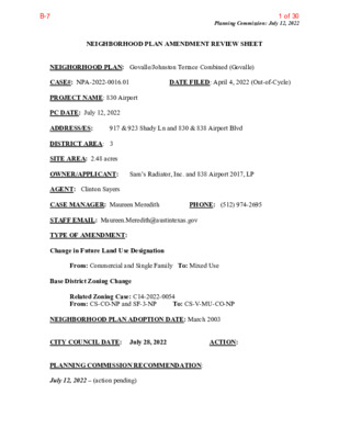
Planning Commission: July 12, 2022 DATE FILED: April 4, 2022 (Out-of-Cycle) NEIGHBORHOOD PLAN AMENDMENT REVIEW SHEET 917 & 923 Shady Ln and 830 & 838 Airport Blvd NEIGHORHOOD PLAN: Govalle/Johnston Terrace Combined (Govalle) CASE#: NPA-2022-0016.01 PROJECT NAME: 830 Airport PC DATE: July 12, 2022 ADDRESS/ES: DISTRICT AREA: 3 SITE AREA: 2.48 acres OWNER/APPLICANT: Sam’s Radiator, Inc. and 838 Airport 2017, LP AGENT: Clinton Sayers CASE MANAGER: Maureen Meredith STAFF EMAIL: Maureen.Meredith@austintexas.gov TYPE OF AMENDMENT: Change in Future Land Use Designation From: Commercial and Single Family To: Mixed Use Base District Zoning Change To: CS-V-MU-CO-NP Related Zoning Case: C14-2022-0054 From: CS-CO-NP and SF-3-NP NEIGHBORHOOD PLAN ADOPTION DATE: March 2003 CITY COUNCIL DATE: July 28, 2022 PLANNING COMMISSION RECOMMENDATION: July 12, 2022 – (action pending) ACTION: PHONE: (512) 974-2695 1 of 30B-7 Planning Commission: July 12, 2022 STAFF RECOMMENDATION: Staff supports the applicant’s request for Mixed Use land use. BASIS FOR STAFF’S RECOMMENDATION: Staff supports the applicant’s request for Mixed Use land use because the property has frontage on Airport Blvd which is an activity corridor where mixed use zoning and land use is appropriate. The applicant proposes a mixed-use development that includes commercial services with residential units, 10% of which will be affordable to households earning 60% of the median family income (MFI). The proposed development will increase the number and variety of housing units to the city and the planning area. Below are sections of the Govalle/Johnston Terrace Combined Neighborhood Plan that supports the applicant’s request. 2 2 of 30B-7 Planning Commission: July 12, 2022 LAND USE DESCRIPTIONS EXISTING LAND USE ON THE PROPERTY Single family - Detached or two family residential uses at typical urban and/or suburban densities. Purpose 1. Preserve the land use pattern and future viability of existing neighborhoods; 2. Encourage new infill development that continues existing neighborhood patterns of development; and 3. Protect residential neighborhoods from incompatible business or industry and the loss of existing housing. Application 1. Existing single‐family areas should generally be designated as single family to preserve established neighborhoods; and 2. May include small lot options (Cottage, Urban Home, Small Lot Single Family) and two‐family residential options (Duplex, Secondary Apartment, Single Family Attached, Two‐Family Residential) in areas considered appropriate for this type of infill development. Commercial -Lots or parcels containing retail sales, services, hotel/motels and all recreational services that are predominantly privately owned and operated for profit (for example, theaters and bowling alleys). Included are private institutional uses (convalescent 3 3 of 30B-7 Planning Commission: July 12, 2022 homes and rest homes in which medical or surgical services are not a main function of the institution), but not hospitals. Purpose 1. Encourage employment centers, commercial activities, and other non‐ residential development to locate along major thoroughfares; and 2. Reserve limited areas for intense, auto‐oriented commercial uses that are generally not compatible with residential or mixed use environments. Application major highways; and 1. Focus the highest intensity commercial and industrial activities along freeways and 2. Should be used in areas with good transportation access such as frontage roads and arterial roadways, which are generally not suitable for residential development. PROPOSED LAND USE ON THE PROPERTY Mixed Use - An area that is appropriate for a mix of residential and non‐residential uses. Purpose 1. Encourage more retail and commercial services within walking distance of residents; 2. Allow live‐work/flex space on existing commercially zoned land in the neighborhood; 3. Allow a mixture of complementary land use types, which may include housing, retail, offices, commercial services, and civic uses (with the exception of government offices) to encourage linking of trips; 4. Create viable development opportunities for underused center city sites; 5. Encourage the transition from non‐residential to residential uses; 6. Provide flexibility in land use standards to anticipate changes in the marketplace; 7. Create additional opportunities for the development of residential uses and affordable housing; and 8. Provide on‐street activity in commercial areas after 5 p.m. and built‐in customers for local businesses. Application 4 4 of 30B-7 Planning Commission: July 12, 2022 1. Allow mixed use development along major corridors and intersections; 2. Establish compatible mixed‐use corridors along the neighborhood’s edge 3. The neighborhood plan may further specify either the desired intensity of commercial uses (i.e. LR, GR, CS) or specific types of mixed use (i.e. Neighborhood Mixed Use Building, Neighborhood Urban Center, Mixed Use Combining District); 4. Mixed Use is generally not compatible with industrial development, however it may be combined with these uses to encourage an area to transition to a more complementary mix of development types; 5. The Mixed Use (MU) Combining District should be applied to existing residential uses to avoid creating or maintaining a non‐conforming use; and 6. Apply to areas where vertical mixed use development is encouraged such as Core Transit Corridors (CTC) and Future Core Transit Corridors. Imagine Austin Decision Guidelines Compact and Connected Measures Imagine Austin Growth Concept Map: Located close to, within or adjacent to an Imagine Austin Activity Center, Imagine Austin Activity Corridor, or Imagine Austin Job Center as identified on the Growth Concept Map. Name(s) of Activity Center/Activity Corridor/Job Center: • The property is located on Airport Blvd which is an activity corridor. Yes Mobility and Public Transit: Located within 0.25 miles of public transit stop and/or light rail station. • The property is located between Shady Lane and Airport Blvd, both of which have public transportation facilities located. Yes Mobility and Bike/Ped Access: Adjoins a public sidewalk, shared path, and/or bike lane. • There does not appear to be sidewalks along the property along Airport Blvd where this property is • There are sidewalks along Shady Lane Yes Connectivity, Good and Services, Employment: Provides or is located within 0.50 miles to goods and services, and/or employment center. • There are numerous businesses located along Airport Blvd. Connectivity and Food Access: Provides or is located within 0.50 miles of a grocery store/farmers market. Connectivity and Education: Is located within 0.50 miles from a public school or university. Yes Connectivity and Healthy Living: Provides or is located within 0.50 miles from a recreational area, park and/or walking trail. • The Govalle Neighborhood Park is located less than ½ mile north of the property Connectivity and Health: Provides or is located within 0.50 miles of health facility (ex: hospital, urgent care, doctor’s office, drugstore clinic, specialized outpatient care.) Yes Housing Affordability: Provides a minimum of 10% of units for workforce housing (80% MFI or less) and/or fee in lieu for affordable houses. • The applicant proposes that 10% of the residential units are affordable to families with 60% of MFI Yes Housing Choice: Expands the number of units and housing choice that suits a variety of household sizes, incomes, and lifestyle needs of a diverse population (ex: apartments, triplex, granny flat, live/work units, cottage homes, and townhomes) in support of Imagine Austin and the Strategic Housing Blueprint. Yes Yes 5 5 of 30B-7 Planning Commission: July 12, 2022 Yes Mixed Use: Provides mixed use development (minimum 10% residential and 10% non-residential floor area). 8 Culture and Creative Economy: Provides or is located within 0.50 miles of a cultural resource (ex: library, theater, museum, cultural center). Total Number of “Yes’s” Imagine Austin Priority Program Bonus Features (Extra Points) Yes Small Area Plan Policies: Supports applicable Small Area Plans, including the Future Land Use Map, goals, objectives, actions and text. List three small area plan policies that relate to this project. • The Govalle/Johnston Terrace Neighborhood Plan supports mixed use projects where people can live and work • The plan supports balances and varied land uses. 1 Culture and Historic Preservation: Preserves or enhances a historically and/or culturally significant site. Culture and Creative Economy: Expands Austin’s creative economy (ex: live music venue, art studio, film, digital, theater.) Workforce Development, the Economy and Education: Expands the economic base by creating permanent jobs, especially an industry that is currently not represented in particular area or that promotes a new technology. Workforce Development, the Economy and Education: Promotes educational opportunities or workforce development training. Imagine Austin Priority Program PUD Specific Bonus Features (Extra Points) Public Space Features and Public Art: Incorporates public space features and/or public art into project (Ex: plazas, streetscapes, gardens, and other people-friendly spaces where different ages can socially interact). Integrates and/or Expands Green Infrastructure: Preserves or expands Austin’s green infrastructure (ex: parkland, community gardens, green streets, creeks, stormwater features that mimic natural hydrology) into the urban environment and transportation network. Protects the Environment: Reduces greenhouse gas emissions, water, energy usage, and/or increases waste diversion. Protects Environmentally Sensitive Lands: Protects Austin’s natural resources and environmental systems by limiting land use and transportation development over or near environmentally sensitive areas, preserves open space, and protects natural resources in excess of ordinance requirements. Water/Waste Water Infrastructure: Sustainably manages Austin’s water resources and stream corridors through on-site use of storm water, effective landscaping, flood mitigation, and other low-impact development techniques in excess of ordinance requirements. Total Number of “Yes’s” Under Bonus Features 6 6 of 30B-7 Proximity to Imagine Austin Activity Centers and Corridors Planning Commission: July 12, 2022 7 7 of 30B-7 Proximity to Park Facilities Planning Commission: July 12, 2022 8 8 of 30B-7 Planning Commission: July 12, 2022 Proximity to Public Transportation IMAGINE AUSTIN GROWTH CONCEPT MAP Definitions Neighborhood Centers - The smallest and least intense of the three mixed-use centers are neighborhood centers. As with the regional and town centers, neighborhood centers are walkable, bikable, and supported by transit. The greatest density of people and activities in neighborhood centers will likely be concentrated on several blocks or around one or two intersections. However, depending on localized conditions, different neighborhood centers can be very different places. If a neighborhood center is designated on an existing commercial area, such as a shopping center or mall, it could represent redevelopment or the addition of housing. A new neighborhood center may be focused on a dense, mixed-use core surrounded by a mix of housing. In other instances, new or redevelopment may occur incrementally and concentrate people and activities along several blocks or around one or two intersections. Neighborhood centers will be more locally focused than either a regional or a town center. Businesses and services—grocery and department stores, doctors and dentists, shops, branch libraries, dry cleaners, hair salons, schools, restaurants, and other small and local businesses—will generally serve the center and surrounding neighborhoods. 9 9 of 30B-7 Planning Commission: July 12, 2022 Town Centers - Although less intense than regional centers, town centers are also where many people will live and work. Town centers will have large and small employers, although fewer than in regional centers. These employers will have regional customer and employee bases, and provide goods and services for the center as well as the surrounding areas. The buildings found in a town center will range in size from one-to three-story houses, duplexes, townhouses, and rowhouses, to low-to midrise apartments, mixed use buildings, and office buildings. These centers will also be important hubs in the transit system. Regional Centers - Regional centers are the most urban places in the region. These centers are and will become the retail, cultural, recreational, and entertainment destinations for Central Texas. These are the places where the greatest density of people and jobs and the tallest buildings in the region will be located. Housing in regional centers will mostly consist of low to high-rise apartments, mixed use buildings, row houses, and townhouses. However, other housing types, such as single-family units, may be included depending on the location and character of the center. The densities, buildings heights, and overall character of a center will depend on its location. Activity Centers for Redevelopment in Sensitive Environmental Areas - Five centers are located over the recharge or contributing zones of the Barton Springs Zone of the Edwards Aquifer or within water-supply watersheds. These centers are located on already developed areas and, in some instances, provide opportunities to address long-standing water quality issues and provide walkable areas in and near existing neighborhoods. State-of-the-art development practices will be required of any redevelopment to improve stormwater retention and the water quality flowing into the aquifer or other drinking water sources. These centers should also be carefully evaluated to fit within their infrastructural and environmental context. Job Centers - Job centers accommodate those businesses not well-suited for residential or environmentally- sensitive areas. These centers take advantage of existing transportation infrastructure such as arterial roadways, freeways, or the Austin-Bergstrom International airport. Job centers will mostly contain office parks, manufacturing, warehouses, logistics, and other businesses with similar demands and operating characteristics. They should nevertheless become more pedestrian and bicycle friendly, in part by better accommodating services for the people who work in those centers. While many of these centers are currently best served by car, the growth Concept map offers transportation choices such as light rail and bus rapid transit to increase commuter options. Corridors - Activity corridors have a dual nature. They are the connections that link activity centers and other key destinations to one another and allow people to travel throughout the city and region by bicycle, transit, or automobile. Corridors are also characterized by a variety of activities and types of buildings located along the roadway — shopping, restaurants and cafés, parks, schools, single-family houses, apartments, public buildings, houses of worship, mixed-use buildings, and offices. Along many corridors, there will be both large and small redevelopment sites. These redevelopment opportunities may be continuous along stretches of the corridor. There may also be a series of small neighborhood centers, connected by the roadway. Other corridors may have fewer redevelopment 10 10 of 30B-7 Planning Commission: July 12, 2022 opportunities, but already have a mixture of uses, and could provide critical transportation connections. As a corridor evolves, sites that do not redevelop may transition from one use to another, such as a service station becoming a restaurant or a large retail space being divided into several storefronts. To improve mobility along an activity corridor, new and redevelopment should reduce per capita car use and increase walking, bicycling, and transit use. Intensity of land use should correspond to the availability of quality transit, public space, and walkable destinations. Site design should use building arrangement and open space to reduce walking distance to transit and destinations, achieve safety and comfort, and draw people outdoors. BACKGROUND: The plan amendment application was filed on April 4, 2022 which is out- of-cycle for neighborhood planning areas located on the east side of I.H.-35. The application was allowed to file out-of-cycle because the Govalle/Johnston Terrance Neighborhood Plan Contact allowed the application to be filed outside of the July open filing period. The applicant proposes to change the land use on the future land use map from Commercial and Single Family to Mixed Use. The applicant proposes to change the zoning on the property from CS-CO-NP (General Commercial Services district- Conditional Overlay combining district- Neighborhood Plan combining district) and SF-3-NP (Family Residence district - Neighborhood Plan combining district) to CS-MU-V-CO-NP (General Commercial Services district - Mixed Use combining district- Vertical Mixed Use Building combining district- Conditional Overlay combining district- Neighborhood Plan combining district to develop a mixed-use project with affordable housing with 10% of the on-site housing units being affordable at 60% of MFI for 40 years. The applicant estimates that 22-25 of these on-site units to be affordable. For more information on the proposed zoning, please see case report C14-2022-0054. PUBLIC MEETINGS: The ordinance-required community meeting was held on May 17, 2022. The recorded meeting can be viewed at https://www.speakupaustin.org/npa. Approximately 221 community meeting notices were mailed to people who own property or have a utility account within 500 feet of the subject tracts, in addition to neighborhood and environmental groups who requested notification for the area. Two city staff members attended the meeting, Maureen Meredith, and Susan Watkins from the Housing and Planning Department in addition to three people associated with the application, Ross Wilson from StoryBuilt, Michael Whellan and Michael Gaudini from Drenner Group. Two people from the neighborhood attended the meeting. Michael Whellan provided the following information. His presentation is provided in this report. • The property is a 2.4 acre site with frontage on Airport Blvd. • We are proposing a mixed-use project with 10% of the on-site housing units being affordable at 60% of MFI for 40 years. We are estimating that 22-25 of these on-site units to be affordable. • We need three approvals, zoning, FLUM and, eventually, a variance. 11 11 of 30B-7 • We are requesting CS-V-CO-MU across entire site to participate in VMU affordable Planning Commission: July 12, 2022 • The future variance is for modified compatibility, but with the support of the affected • The applicant has worked with the G/JT NPCT to meet this compromise housing program adjacent properties. development. • There will be a zoning buffer from most of the single-family lots. • The two immediate adjacent property owners support our request. • The site has flood plain constraints which we will be sensitive to. • Ross Wilson has worked with neighborhood since November 2021 to come up with compromise plan. Originally, we asked for a multifamily development which would not have required affordable housing, but with the compromise agreement, we are not asking for VMU which will require it. • The existing two residents on the property will have the right to return in the new • The Contact Team wanted limited access to Shady Lane, except for emergency development. access. • Will provide a contribution to the East Austin Conservancy. Q: Neighborhood wants the affordable units to be for families, not just have studio units. Is there a breakdown of the size of the units? Also, the neighborhood wants to have retail in the development, especially Goodwill Industries. A: Goodwill’s lease ends at the end of next year and they will not extend their lease. They want to own real estate on Airport Blvd, so they are looking for property. The current site does not have a loading area, so this location doesn’t work for them. The neighborhood felt the 60-foot height limit was critical here which limited the size of the project. MF-6 allowed for more units, but when we when to VMU with the affordable units that limited the pro rata mix of units and the size of the units. The plan is a mix of predominantly one and two bedrooms with a few three-bedroom apartments. Q: Will there be retail in the project? A: Right now, we have plans for the ground floor retail to comply with VMU regulations. Q: How will VMU II affect this property if it does pass? Will you be able to build taller if this passes? A: Compatibility is going to limit this property from taking advantage of additional height on the corridor which is the main proposal for VMU II. In fact, I think it even limits some of the edges of the project to less than 60-feet based on the SF-3 zoning from the properties on Gullett Street and from 905 Shady Lane. It’s hard to tell at this point what will happen with the VMU II, so it’s difficult to tell. Q: If VMU II Passes, would you refile your NPA and zoning applications so you can get 90 feet? A: This would be a client determination, but if we refiled, we would have to come back to you and time is of importance for us and refiling would change the timeframe. You don’t have to worry about this. 12 12 of 30B-7 Planning Commission: July 12, 2022 Q: Are the current owners retaining ownership through the project? A: Sam is under contract to the ownership group of the property. The intent is for the ownership group to participate in the development. 13 13 of 30B-7 Applicant Summary Letter from Application Planning Commission: July 12, 2022 14 14 of 30B-7 Out-of-Cycle Letter Authorization from Neighborhood Plan Contact Team (NPCT) Planning Commission: July 12, 2022 -----Original Message----- From: Daniel Llanes Sent: Tuesday, January 25, 2022 5:07 PM To: Meredith, Maureen <Maureen.Meredith@austintexas.gov> Cc: jarred corbell; ross wilson Subject: G/JTNP Contact Team sponsors Out of cycle application for 830 Airport *** External Email - Exercise Caution *** Hi Maureen, Please accept this email confirming that the Govalle/Johnston Neighborhood Contact Team is sponsoring an Out-of-Cycle zoning change application for 830 Airport. Please communicate with Jarred Corbell, copied here, for application details, and let me know if you need anything else from me regarding this out-of-cycle application. Thank you, Daniel Llanes, Chair G/JTNP Contact Team 512-431-9665 15 15 of 30B-7 Letter of Recommendation from the Neighborhood Plan Contact Team (NPCT) Planning Commission: July 12, 2022 16 16 of 30B-7 Planning Commission: July 12, 2022 Site 17 17 of 30B-7 Planning Commission: July 12, 2022 18 18 of 30B-7 Planning Commission: July 12, 2022 19 19 of 30B-7 Planning Commission: July 12, 2022 20 20 of 30B-7 Planning Commission: July 12, 2022 21 21 of 30B-7 Planning Commission: July 12, 2022 22 22 of 30B-7 Applicant’s Presentation at the May 17, 2022 Community Meeting Planning Commission: July 12, 2022 23 23 of 30B-7 Planning Commission: July 12, 2022 24 24 of 30B-7 Planning Commission: July 12, 2022 25 25 of 30B-7 Planning Commission: July 12, 2022 26 26 of 30B-7 Planning Commission: July 12, 2022 27 27 of 30B-7 Planning Commission: July 12, 2022 28 28 of 30B-7 Planning Commission: July 12, 2022 29 29 of 30B-7 Planning Commission: July 12, 2022 30 30 of 30B-7