B-16 SP-2021-0079C - Sky Mountain; District 8 Part1.pdf — original pdf
Backup
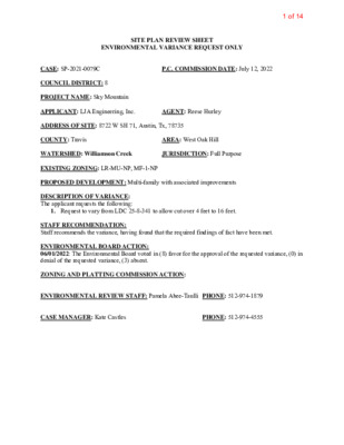
SITE PLAN REVIEW SHEET ENVIRONMENTAL VARIANCE REQUEST ONLY CASE: SP-2021-0079C P.C. COMMISSION DATE: July 12, 2022 COUNCIL DISTRICT: 8 PROJECT NAME: Sky Mountain APPLICANT: LJA Engineering, Inc. AGENT: Reese Hurley ADDRESS OF SITE: 8722 W SH 71, Austin, Tx, 78735 COUNTY: Travis WATERSHED: Williamson Creek AREA: West Oak Hill JURISDICTION: Full Purpose EXISTING ZONING: LR-MU-NP, MF-1-NP PROPOSED DEVELOPMENT: Multi-family with associated improvements DESCRIPTION OF VARIANCE: The applicant requests the following: 1. Request to vary from LDC 25-8-341 to allow cut over 4 feet to 16 feet. STAFF RECOMMENDATION: Staff recommends the variance, having found that the required findings of fact have been met. ENVIRONMENTAL BOARD ACTION: 06/01/2022: The Environmental Board voted in (8) favor for the approval of the requested variance, (0) in denial of the requested variance, (3) absent. ZONING AND PLATTING COMMISSION ACTION: ENVIRONMENTAL REVIEW STAFF: Pamela Abee-Taulli PHONE: 512-974-1879 CASE MANAGER: Kate Castles PHONE: 512-974-4555 1 of 14 1 ENVIRONMENTAL COMMISSION MOTION 20220601 003b Date: June 1, 2022 Subject: Sky Mountain, SP-2021-0079C Seconded by: Kevin Ramberg Motion by: Jennifer L. Bristol RATIONALE: WHEREAS, the Environmental Commission recognizes the applicant is requesting a variance from LDC 25- 8-341 to allow cut over 4 feet to 16 feet; and WHEREAS, the Environmental Commission recognizes the site is located in the Williamson Creek, Barton Springs Zone Classification, Drinking Water Protection Zone; and WHEREAS, the Environmental Commission recognizes that Staff recommends this variance, (with three staff conditions) having determined the required Findings of Fact have been met. THEREFORE, the Environmental Commission recommends the variance request with the following: Staff Conditions: 1. All grading over 8 feet will be contained with terracing or engineered walls. 2. Around the perimeter of the limits of construction, and in areas where more than 3’ of vertical rise is proposed, 3:1 slopes will have erosion control matting applied immediately after final grade is achieved. 3. Disturbance in the stormwater irrigation fields will be minimized by restricting the LOC and routing the irrigation lines to preserve existing trees to the greatest extent possible. VOTE 8-0 Approved By: For: Thompson, Schiera, Nickells, Bristol, Ramberg, Aguirre, Brimer, Bedford Against: None Abstain: None Recuse: None Absent: Qureshi, Scott, and Barrett Bixler Kevin Ramberg, Environmental Commission Chair 2 of 14 Development Services Department Staff Recommendations Concerning Required Findings Project Name: Ordinance Standard: Watershed Protection Ordinance Variance Request: Sky Mountain Request to vary from LDC 25-8-341 to allow cut over 4 feet to 16 feet. Include an explanation with each applicable finding of fact. A. City Code: Land Use Commission variance determinations from Chapter 25-8-41 of the 1. The requirement will deprive the applicant of a privilege available to owners of similarly situated property with approximately contemporaneous development subject to similar code requirements. Yes The existing site conditions include areas of previously imported fill material that occurred prior to the adoption of developmental regulations requiring site plan applications. According to aerial information, the fill dates back to the early 1980s. As such the existing conditions do not represent the grades that would have occurred naturally. Because the fill has very steep slopes and is not compacted, it is not suitable for building on. This is why the applicant proposes to cut back the fill to such a degree. 2. The variance: a) Is not necessitated by the scale, layout, construction method, or other design decision made by the applicant, unless the design decision provides greater overall environmental protection than is achievable without the variance; Yes The variance is not necessitated by design decisions made by the applicant. The variance is necessitated by up to 20 feet of uncompacted fill that was placed on the site in the early 1980s, before this area was annexed by the City. The fill was placed in an uncontrolled manner that is not viable to build on, making it infeasible to develop the 3 of 14 property without removing much of it. The removal of the fill and development of the site in will reduce the potential for erosion on these man-made steep slopes. Is the minimum deviation from the code requirement necessary to allow a reasonable use of the property; Yes The proposed grading is the minimum necessary to develop the site. The placement of fill on the property within the subject area created an un-natural embankment that cannot be developed upon. The man-made slopes have a gradient as steep as 50 percent and are steeper than desirable for development. Moreover, the fill contains unsuitable material. The development proposed cut up to 16 feet, which is the minimum necessary to level and stabilize the site. Does not create a significant probability of harmful environmental consequences. Yes The development would not create a probability of harmful environmental consequences. It would improve the environment by minimizing erosion and removing improperly compacted fill. Although the subject area has naturally revegetated over time, the possibility of harmful erosion occurring is still a valid concern if the slopes are left. Code-compliant erosion and sedimentation controls will be provided both during and after construction activities. All grading will be permanently stabilized in a code- complaint fashion. 3. Development with the variance will result in water quality that is at least equal to the water quality achievable without the variance. Yes Water quality will be provided in accordance with current City of Austin standards, therefore it will be equal to the water quality that would be provided without the variance. Because this site is in the Barton Springs Zone, water quality controls will meet the “non-degradation” standard required by the Save Our Springs ordinance. This means that runoff from the site shall cause no net increase in average annual pollutant load compared to existing conditions. Storm water detention for ATLAS-14 flood flows is also being provided. b) c) 4 of 14 B. The Land Use Commission may grant a variance from a requirement of Section 25-8-422 (Water Supply Suburban Water Quality Transition Zone), Section 25-8- 452 (Water Supply Rural Water Quality Transition Zone), Section 25-8-482 (Barton Springs Zone Water Quality Transition Zone), Section 25-8-368 (Restrictions on Development Impacting Lake Austin, Lady Bird Lake, and Lake Walter E. Long), or Article 7, Division 1 (Critical Water Quality Zone Restrictions ), after determining that:: 1. 2. 3. The criteria for granting a variance in Subsection (A) are met; NA The requirement for which a variance is requested prevents a reasonable, economic use of the entire property; NA The variance is the minimum deviation from the code requirement necessary to allow a reasonable, economic use of the entire property. NA Staff Determination: Staff determines that the findings of fact have been met. Staff recommends the following conditions: 1. All grading over 8 feet will be contained with terracing or engineered walls. 2. Around the perimeter of the limits of construction, and in areas where more than 3’ of vertical rise is proposed, 3:1 slopes will have erosion control matting applied immediately after final grade is achieved. 3. Disturbance in the stormwater irrigation fields will be minimized by restricting the LOC and routing the irrigation lines to preserve existing trees to the greatest extent possible. Environmental Reviewer (DSD) Environmental Review Manager (DSD) Deputy Environmental Officer (WPD) __________________ (Pamela Abee-Taulli) __________________ (Mike McDougal) __________________ (Liz Johnston) Date: 4/27/22 Date: 5/6/22 Date: 05/23/20205 of 14 April 22, 2022 ENVIRONMENTAL COMMISSION VARIANCE APPLICATION FORM Street Address LJA Engineering, 7500 Rialto Blvd, Bldg 2, Ste 100 PROJECT DESCRIPTION Applicant Contact Information Name of Applicant S. Danny Miller, P.E. City State ZIP Code Austin, TX 78735 Work Phone (512) 439-4700 E-Mail Address dmiller@LJA.com Variance Case Information Case Name Sky Mountain Case Number SP-2021-0079C Address or Location 8722 W. SH 71, Austin, TX 78735 Environmental Reviewer Name Environmental Resource Management Reviewer Name Pamela Abee-Taulli Applicable Ordinance Watershed Protection Ordinance / Current code Watershed Name Williamson Creek Watershed Classification ☐Urban ☐ Suburban ☐Water Supply Suburban ☐Water Supply Rural X Barton Springs Zone City of Austin | Environmental Commission Variance Application Guide 1 6 of 14 April 22, 2022 Edwards Aquifer Recharge Zone ☐ Barton Springs Segment ☐ Northern Edwards Segment X Not in Edwards Aquifer Zones Edwards Aquifer Contributing Zone Distance to Nearest Classified Waterway Water and Waste Water service to be provided by X Yes ☐ No Approximately 130’ to the east. Austin Water Request The variance request is as follows (Cite code references): Request to vary from LDC §25-8-341 Cut Requirements to allow cut above 4 feet in the subject area within the Barton Springs Zone. The below reported impervious cover is that just for the northern part of the project, as explained in the provided summary letter. Impervious cover square footage: acreage: percentage: Provide general description of the property (slope range, elevation range, summary of vegetation / trees, summary of the geology, CWQZ, WQTZ, CEFs, floodplain, heritage trees, any other notable or outstanding characteristics of the property) Existing 0 SF 0 AC. 0% Proposed 184,888 4.244 AC. 24.28% The subject area within the overall project that dictates this required variance is approximately 6.72 acres in size and is located within the existing Mountain Shadows Subdivision. Existing earthen slopes in the subject area range from 5% up to 50% as shown on the existing slope map exhibit. Approximately 75% of the existing slopes within the overall subject were created by the placement of fill that occurred sometime during the early 1980’s. A high elevation of 1,013 ft-msl occurs in the SE corner of existing Lot Q of Mountain Shadows Subdivision with a low elevation of approximately 955 ft-msl on existing Lot P of Mountain Shadows Subdivision. The subject property is characterized by Edward Plateau, Deciduous Oak/Evergreen Motte and Woodland, Ashe Juniper Motte and Woodland, and Ashe Juniper - Live Oak Shrubland (TPWD, 2020). The majority of the vegetation on the subject property are Ashe Juniper, Sugar Hackberry, and Cedar Elm. There are two Heritage Trees within the subject area that will not be affected by the proposed grading of the site. There is not an existing or required City of Austin 100-Year Floodplain delineation or waterway on the property dictating a required CWQZ and WQTZ. There is not an applicable FEMA 100-Year Floodplain per FEMA FIRM No. 48453C0420J, dated 01/22/2020. As indicated in the ERI, there are no applicable CEF’s. City of Austin | Environmental Commission Variance Application Guide 2 7 of 14 April 22, 2022 FINDINGS OF FACT Project: Sky Mountain Ordinance: 20131017-046 A. 1. Clearly indicate in what way the proposed project does not comply with current Code (include maps and exhibits) The proposed project would not be able to meet the cut requirements of 25-8-341. The project must remove a substantial amount of fill that was placed by previous owners in the early 1980’s. The removal of the fill in the subject area will exceed the maximum allowed 4’ cut requirement per COA LDC 25-8-341 as shown by the attached cut and fill exhibit and cross sections. Additionally, the required amount of cut cannot be allowed by an administrative variance per COA LDC 25-8-42 and the project is located in the BSZ. As required in LDC Section 25-8-41, in order to grant a variance the Land Use Commission must make the following findings of fact: Include an explanation with each applicable finding of fact. Land Use Commission variance determinations from Chapter 25-8-41 of the City Code: The requirement will deprive the applicant of a privilege available to owners of similarly situated property with approximately contemporaneous development subject to similar code requirements. Yes, because the placement of uncompacted fill in the subject area created unnatural embankments with fills up to approximately 20’ in the worst-case areas that were not the result of any action performed by the current landowner, thus causing a condition that makes it infeasible to develop the property without removing up to 20’ of fill material in the worst-case areas. Additionally, this material was placed in an uncontrolled manner that is not viable to build on. 2. The variance: a) Is not necessitated by the scale, layout, construction method, or other design decision made by the applicant, unless the design decision provides greater overall environmental protection than is achievable without the variance; Yes, the variance is not necessitated because of scale, layout, construction method, or design decision but because of previously placed fill that has caused City of Austin | Environmental Commission Variance Application Guide 3 8 of 14 April 22, 2022 a hardship on the property for purposes of the proposed development. Not granting the variance would require the development to occur on land that is currently proposed to remain natural, versus being located on previously disturbed land. The proposed design of the project will provide water quality controls for the entire proposed project in accordance with current City of Austin Regulations for projects located in the Barton Springs Zone (SOS Standards). The removal of the placed fill and development of the site in general will reduce the potential for erosion on the man-made steep slopes. Is the minimum deviation from the code requirement necessary to allow a reasonable use of the property; Yes, the placement of fill on the property within the subject area created an un- natural embankment and associated slopes in the subject area that cannot be developed upon. The property is to be developed with multifamily apartments and associated site improvements. If the variance is not approved the site becomes undevelopable due to a private restrictive covenant with the adjacent community that prohibits access to Mountain Shadows Drive. Non approval of the variance would require disturbance of existing natural area rather than previously disturbed area. Does not create a significant probability of harmful environmental consequences. Yes, development with the variance does not create a probability of harmful environmental consequences. The development would in fact improve the environment by minimizing erosion and removing improperly compacted fill. The project will remove a substantial amount of fill that was placed on the site in the early 1980’s which was not conditioned and therefore is not suitable for development purposes. Although the subject area has naturally revegetated over time, the man-made slopes that were created in the subject area are steeper than desirable for development and contain unsuitable material. The possibility of harmful erosion occurring over time is still a valid concern on the man-made slopes if left to remain. b) c) Code-compliant erosion and sedimentation controls will be provided both during and after construction activities. All grading will be permanently stabilized in a code-complaint fashion. 3. Development with the variance will result in water quality that is at least equal to the water quality achievable without the variance. Yes, water quality will be provided in accordance with current City of Austin standards, therefore code-compliant and equal to the water quality that would be provided without the variance. Because this site is in the Barton Springs Zone, water quality controls will meet the “non-degradation” standard required City of Austin | Environmental Commission Variance Application Guide 4 9 of 14 April 22, 2022 by the Save Our Springs ordinance. This means that runoff from the site shall cause no net increase in average annual pollutant load compared to existing conditions. Storm water detention for ATLAS-14 flows is also being provided. B. Additional Land Use Commission variance determinations for a requirement of Section 25-8-422 (Water Quality Transition Zone), Section 25-8-452 (Water Quality Transition Zone), Article 7, Division 1 (Critical Water Quality Zone Restrictions), or Section 25-8-368 (Restrictions on Development Impacting Lake Austin, Lady Bird Lake, and Lake Walter E. Long): 1. 2. 3. The criteria for granting a variance in Subsection (A) are met; Not Applicable The requirement for which a variance is requested prevents a reasonable, economic use of the entire property; Not Applicable The variance is the minimum deviation from the code requirement necessary to allow a reasonable, economic use of the entire property. Not Applicable **Variance approval requires all above affirmative findings. City of Austin | Environmental Commission Variance Application Guide 5 10 of 14 April 22, 2022 A Exhibits for Commission Variance Aerial Site Exhibit Aerial Vicinity Exhibit Context Map Exhibit Topographic Exhibit Environmental Exhibits Cut & Fill Exhibit with Cross Sections Existing Site conditions Exhibit Overall Site Exhibit Environmental Resource Inventory including site photos. Variance request letter City of Austin | Environmental Commission Variance Application Guide 6 11 of 14 SKY MOUNTAIN DRMOUNTAIN SHADOWS DRMOUNTAINSHADOWSCVMOUNTAIN CREST DRPath: K:\GIS\LJA Austin\Due Diligence Report\A439-0401\A439.0401.aprxTHIS PRODUCT IS FOR INFORMATIONAL PURPOSES AND MAY NOTHAVE BEEN PREPARED FOR OR BE SUITABLE FOR LEGAL,ENGINEERING, OR SURVEYING PURPOSES. IT DOES NOTREPRESENT AN ON-THE-GROUND SURVEY AND REPRESENTSONLY THE APPROXIMATE RELATIVE LOCATION OF PROPERTYBOUNDARIES.AERIAL PHOTOGRAPH DATE: NEARMAP 2022TRAVISCOUNTY010020050FEETDATA SOURCE: AUSTIN CITY LIMITS - TRAVIS COUNTYSITE BOUNDARYLEGENDAPRIL 2022AUSTIN CITY LIMITSAERIAL - SITE EXHIBITAPPROX. 22 AC.A439-0401SKY MOUNTAIN TRACTNORTH TRACTNORTH TRACTSOUTH TRACT12 of 14 ³±71SUNSET RDGSMOKEYHILLRDOLDBEECAVESRDSKY MOUNTAIN DRMEDICINECREEKDRMOUNTAIN SHADOWS DRSILVERMINEDRCOVEREDBRIDGEDRREHOBETHCIRTRAVISHILLSDRSHUMARDOAKTRLCEDARELMTRLRACCOONRUNTRAVIS COOK RDBELL DRMOUNTAIN CREST DRFORTBENTONDRPath: K:\GIS\LJA Austin\Due Diligence Report\A439-0401\A439.0401.aprxTHIS PRODUCT IS FOR INFORMATIONAL PURPOSES AND MAY NOTHAVE BEEN PREPARED FOR OR BE SUITABLE FOR LEGAL,ENGINEERING, OR SURVEYING PURPOSES. IT DOES NOTREPRESENT AN ON-THE-GROUND SURVEY AND REPRESENTSONLY THE APPROXIMATE RELATIVE LOCATION OF PROPERTYBOUNDARIES.AERIAL PHOTOGRAPH DATE: NEARMAP 2022TRAVISCOUNTY05001,000250FEETDATA SOURCE: AUSTIN CITY LIMITS - TRAVIS COUNTYSITE BOUNDARYLEGENDAPRIL 2022AUSTIN CITY LIMITSAERIAL - VICINITY EXHIBITAPPROX. 22 AC.A439-0401SKY MOUNTAIN TRACTNORTH TRACTNORTH TRACTSOUTHTRACT13 of 14 TRAVISCOUNTYMUD 8TRAVISCOUNTYMUD 5TRAVISCOUNTYMUD 9TRAVISCOUNTYMUD 7TRAVISCOUNTYMUD 6TRAVISCOUNTYMUD 3TRAVIS COUNTY MUD4 SEWERTRAVIS COUNTYMUD 4 SEWERTRAVIS COUNTYMUD 4 SEWERHIGH VALLEY WSCBARTONCREEK WSCTRAVISCOUNTYWCID 19CITY OFAUSTINCITY OF AUSTINCITY OFAUSTINWEST TRAVISCOUNTY PUBLICUTILITY AGENCYWEST TRAVISCOUNTY PUBLICUTILITY AGENCY£¤290³±71OLDBEECAVESRDLEDGESTONETERSUNSETRDGBLUEHILLDRWIER HILLS RDTHUNDERBIRDRDCIRCLE DRRAWHIDETRLTHOMASSPRINGSRDPEAKRIDGEDRSCHOOLRDVEGAAVEHENRYMARXLNLOSTCREEKBLVDLENAPETRLSANDIALOOPWIER LOOP RDBARTONCREEKBLVDEMILLNVIEWRDTERRAVISTADRBELL DRKAYLNROD RDWILLIAMCANNONDRWEIRLOOPCIREIGERRDSOUTHWESTPKWYVIKKITERLAURIE LNSELWAYDRRIALTOBLVDROAN LNCHINOOKDRSOUTH VIEW RDELREYBLVDCLAXTON DRWESTVIEW RDTARALNRIMSTONETRLREYNOLDSRDLAURALANDRMIRADORDRDORELLALNSAMCARTERDRESCALADRPROPOSED FWY 6PROPOSED FWY 6PROPOSEDEXISTINGPROPOSEDFWY6PROPOSEDMAD4PROPOSEDEXISTINGPROPOSEDMAD4PROPOSEDEXISTINGPROPOSED FWY 6PROPOSEDEXISTINGPath: K:\GIS\LJA Austin\Due Diligence Report\A439-0401\A439.0401.aprxTHIS PRODUCT IS FOR INFORMATIONAL PURPOSES AND MAY NOTHAVE BEEN PREPARED FOR OR BE SUITABLE FOR LEGAL,ENGINEERING, OR SURVEYING PURPOSES. IT DOES NOTREPRESENT AN ON-THE-GROUND SURVEY AND REPRESENTSONLY THE APPROXIMATE RELATIVE LOCATION OF PROPERTYBOUNDARIES.AERIAL PHOTOGRAPH DATE: NEARMAP 2022TRAVISCOUNTY2,00001,000FEET*DISTRICT BOUNDARIES FROM OFFICAL DATARELEASE ARE OFTEN SHIFTED FROM ACTUALBOUNDARY.DATA SOURCE: SCHOOL DISTRICTS - TEA, CCNS - PUC, RTP -CAMPO, MUDS - TCEQSITE BOUNDARYREGIONAL TRANSPORTATION PLANCCN SEWER BOUNDARIES*CCN WATER BOUNDARIES*LEGENDAPRIL 2022CONTEXT EXHIBITAPPROX. 22 AC.A439.0401SKY MOUNTAIN TRACT14 of 14 Additional backup may be found at the link below. https://www.austintexas.gov/cityclerk/boards_commissions/meetings/40_1.htm