B-05 C814-2012-0085.02 - Texas Children's Hospital - Austin South Campus; District 5.pdf — original pdf
Backup
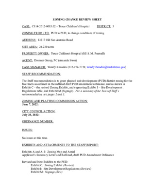
DISTRICT: 5 ZONING CHANGE REVIEW SHEET CASE: C814-2012-0085.02 – Texas Children’s Hospital ZONING FROM / TO: PUD to PUD, to change conditions of zoning ADDRESS: 13217 Old San Antonio Road SITE AREA: 24.230 acres PROPERTY OWNER: Texas Children's Hospital (Jill S. M. Pearsall) AGENT: Drenner Group, PC (Amanda Swor) CASE MANAGER: Wendy Rhoades (512-974-7719, wendy.rhoades@austintexas.gov) STAFF RECOMMENDATION: The Staff recommendation is to grant planned unit development (PUD) district zoning for the five tracts as outlined in the redlined draft PUD amendment ordinance, and as shown in Exhibit C – the revised Zoning Exhibit, and supporting Exhibit I – Site Development Regulations table, and Exhibit M (Signage). For a summary of the basis of Staff’s recommendation, see pages 2 and 3. ZONING AND PLATTING COMMISSION ACTION: June 7, 2022: CITY COUNCIL ACTION: July 28, 2022: ORDINANCE NUMBER: ISSUES: No issues at this time. EXHIBITS AND ATTACHMENTS TO THE STAFF REPORT: Exhibits A and A-1: Zoning Map and Aerial Applicant’s Summary Letter and Redlined, draft PUD Amendment Ordinance Revised and New Exhibits to the PUD: Exhibit C: Zoning Exhibit (Revised) Exhibit I: Site Development Regulations (Revised) Exhibit M: Signage (New) C814-2012-0085.02 Page 2 Correspondence Received CASE MANAGER COMMENTS: The proposed second amendment to the Estancia Hill Country Planned Unit Development (PUD) consists of one undeveloped, unplatted 24.230 acre tract located at the northwest corner of the southbound IH 35 frontage road and Puryear Road. Old San Antonio Road bounds the property on the west side and Avenida Mercado Street on its north side. Council approved conversion of the Property from the limited purpose jurisdiction to the full purpose jurisdiction on April 21, 2022 (C7a-2022-0003). Please refer to Exhibits A (Zoning Map) and A-1 (Aerial View). The proposed amendment consists of the following components: 1) add a new land use parcel to be designated as CS-MU (Hospital Tract); 2) require a minimum 2-Star Green Building Rating; 3) amend the permitted, conditional and prohibited uses and to exempt a hospital services (general) use from Subchapter E (Design Standards and Mixed Use); 4) amend the sign regulations for a hospital services (general) use; and 5) amend the site development regulations to allow up to 120 feet in height. Please refer to Applicant’s Summary Letter and Redlined, draft PUD Amendment Ordinance. BASIS OF STAFF RECOMMENDATION: 1. The proposed zoning should be consistent with the purpose statement of the district sought. Per the Land Development Code, PUD district zoning was established to implement goals of preserving the natural environment, encouraging high quality, sustainable development and innovative design, and ensuring adequate public facilities and services. The City Council intends PUD district zoning to produce development that achieves these goals to a greater degree than and thus is superior to development which could occur under conventional zoning and subdivision regulations. The PUD provides a canvas for the design of a large scale project, with the end goal to allow flexibility, and also inform and communicate the possibilities for development. Additional effort is required by all parties to ensure that development standards are clear and municipal and citizen needs are addressed. The PUD ordinance and related exhibits are key because once approved, they provide the regulations under which the project will be built, which provides certainty for developers and their agents. 2. Zoning should promote the policy of locating retail and more intensive zoning near the intersections of arterial roadways or at the intersections of arterials and major collectors. Staff recommends the Applicant’s request because the tract is bounded by four roadways, including existing highway frontage and in proximity to SH 45 Eastbound and is within close proximity to the Southside Regional Center as identified on the Growth Concept Map in the Imagine Austin Comprehensive Plan. The CS-MU zoning district that would apply to this property is compatible with the CS-MU-V and GR-MU designations for the apartments C814-2012-0085.02 Page 3 under construction across Avenida Mercado Street to the north and the GR-MU designation for property within the PUD west of Old San Antonio Road. The proposed PUD amendment will permit the proposed hospital use along a highway and provide medical services at a regional scale to the southern portion of Austin and Hays County as well. EXISTING ZONING AND LAND USES: ZONING Sites North PUD PUD South County East West N/A PUD; County LAND USES Undeveloped Undeveloped; Under construction for 318 multifamily residences on 15.30 acres Undeveloped IH 35 Service Road southbound and main lanes Undeveloped; Residential SCENIC ROADWAY: No NEIGHBORHOOD PLAN AREA: Not Applicable TIA: Completed with C814-2012-0085 in June 2013 WATERSHED: Onion Creek – Suburban CAPITOL VIEW CORRIDOR: No SCHOOLS: Menchaca Elementary School Paredes Middle School Akins High School COMMUNITY REGISTRY LIST: 231 – Onion Creek Meadow Property Owners Association 627 – Onion Creek Homeowners Association 742 – Austin Independent School District 1258 – Del Valle Community Coalition 1228 – Sierra Club, Austin Regional Group 1363 – SEL Texas 1530 – Friends of Austin Neighborhoods 1616 – Neighborhood Empowerment Foundation 1774 – Austin Lost and Found Pets AREA CASE HISTORIES: There are no recent cases in the vicinity. RELATED CASES: The Estancia Hill Country PUD is comprised of 593.6 acres and bounded by Onion Creek to the north, the southbound IH 35 Service Road to the east, Puryear Road to the south, and single family residences in the Onion Creek Meadows subdivision and residences on large lots and undeveloped land to the west (County). C814-2012-0085.02 Page 4 On June 20, 2013, Council approved the Estancia Hill Country PUD for a mixed use project that may be developed with up to 737 single family residential units, 1,550 multi-family residential units, 1.65 million square feet of office/commercial uses, 400,000 square feet of retail, and over 100 acres of open space (C814-2012-0085 – Ordinance No. 20130620-077. A two acre City of Austin Fire / EMS station site and a nine acre site for a multi modal transportation facility are proposed to be located near the southeast corner of Tract II. In general, parkland/open space is located in proximity to Onion Creek and along the west side of Old San Antonio Road, and single family residences on the north central portion of the site. The remainder of the property is to be developed with a broad mix of multi-family, office, retail, and civic uses. The first amendment to the PUD involved removing a sentence in Part 2 of the original PUD ordinance that inadvertently contained grandfathering of development standards, thereby locking them in for the life of this PUD (C814-2012-0085.01). The sole purpose of the first was to remove this sentence from the ordinance and insert the following standard language in its place: “Except as otherwise specifically provided by this ordinance, all other rules, regulations and ordinances of the City apply to the Estancia Hill Country PUD.” Council approved the first amendment on December 11, 2014 (Ordinance No. 20141211-177). EXISTING STREET CHARACTERISTICS: Name ASMP Classification ASMP Required ROW Existing ROW Existing Pavement Sidewalks Bicycle Route Old San Antonio Road Level 2 78’ 68’ IH 35 SVRD SB Level 4 None Varies 25’ 40’ Puryear Rd Level 2 57’ – 91’ 28’ – 31’ No Avenida Mercado St Level 1 90’ – 120’ 40’ (w/median) SH 45 SW Level 5 Defer to TxDOT 0’ 0’ 60’ 60’ Capital Metro (within ¼ mile) Yes No Yes No Shared Lane Shared Lane Shared Lane Shared Lane No No No No No No C814-2012-0085.02 Page 5 OTHER STAFF COMMENTS: Inclusive Planning Yes Imagine Austin Decision Guidelines Compact and Connected Measures Y Imagine Austin Growth Concept Map: Located close to, within or adjacent to an Imagine Austin Activity Center, Imagine Austin Activity Corridor, or Imagine Austin Job Center as identified on the Growth Concept Map. Name of Activity Center/Activity Corridor/Job Center: 900 ft from the Southside Regional Center Mobility and Public Transit: Located within 0.25 miles of public transit stop and/or light rail station. Y Mobility and Bike/Ped Access: Adjoins a public sidewalk, shared path, and/or bike lane. Y Connectivity, Good and Services, Employment: Provides or is located within 0.50 miles to goods and services, and/or employment center. Connectivity and Food Access: Provides or is located within 0.50 miles of a grocery Connectivity and Education: Is located within 0.50 miles from a public school or store/farmers market. university. Connectivity and Healthy Living: Provides or is located within 0.50 miles from a recreational area, park and/or walking trail. Y Connectivity and Health: Provides or is located within 0.50 miles of health facility (ex: hospital, urgent care, doctor’s office, drugstore clinic, specialized outpatient care.) Housing Affordability: Provides a minimum of 10% of units for workforce housing (80% MFI or less) and/or fee in lieu for affordable house. Housing Choice: Expands the number of units and housing choice that suits a variety of household sizes, incomes, and lifestyle needs of a diverse population (ex: apartments, triplex, granny flat, live/work units, cottage homes, and townhomes) in support of Imagine Austin and the Strategic Housing Blueprint. Mixed Use: Provides mixed use development (minimum 10% residential and 10% non- residential floor area). Culture and Creative Economy: Provides or is located within 0.50 miles of a cultural resource (ex: library, theater, museum, cultural center). 4 Total Number of “Yes’s” Imagine Austin Priority Program PUD Specific Bonus Features (Extra Points) Y Public Space Features and Public Art: Incorporates public space features and/or public art into project (Ex: plazas, streetscapes, gardens, and other people-friendly spaces where different ages can socially interact). Integrates and/or Expands Green Infrastructure: Preserves or expands Austin’s green infrastructure (ex: parkland, community gardens, green streets, creeks, stormwater features that mimic natural hydrology) into the urban environment and transportation network. Y Protects the Environment: Reduces greenhouse gas emissions, water, energy usage, and/or increases waste diversion. Protects Environmentally Sensitive Lands: Protects Austin’s natural resources and environmental systems by limiting land use and transportation development over or near C814-2012-0085.02 Page 6 environmentally sensitive areas, preserves open space, and protects natural resources in excess of ordinance requirements. Y Water/Waste Water Infrastructure: Sustainably manages Austin’s water resources and stream corridors through on-site use of storm water, effective landscaping, flood mitigation, and other low-impact development techniques in excess of ordinance requirements. 7 Total Number of “Yes’s” Under Bonus Features and Up Top Drainage The developer is required to submit a pre- and post-development drainage analysis at the subdivision and site plan stage of the development process. The City’s Land Development Code and Drainage Criteria Manual require that the Applicant demonstrate through engineering analysis that the proposed development will have no identifiable adverse impact on surrounding properties. Environmental Office – Watershed Protection Department Protection of the wetland critical environmental feature (CEF) and associated setback through the installation of a physical barrier (e.g. split rail fence, limestone block border) to be established during the site development permit process. Environmental Review – Development Services Department No comments on this PUD Amendment. Flood Plain Bounded by Puryear to the south, Avenida Mercado to the north, IH35 to the east and Old San Antonio to the west. Site wishes to change PUD zoning, height restrictions, and signage requirements for a proposed hospital. Site is not located in or near a floodplain / Critical Water Quality Zone (CWQZ). PARD – Planning & Design Review Property is currently subject to the Estancia PUD and development agreement, which does not account for any additional applicable uses here. To remedy that, specify in the ordinance that: “Development of any applicable uses on the Property is subject to Title 25-1, Article 14, Parkland Dedication, as amended”. Site Plan Staff comments will be provided at time of site plan submittal. No site plan comments on the PUD amendment. C814-2012-0085.02 Page 7 Austin Transportation Department – Engineering Review The site is subject to the approved TIA with zoning case # C814-2012-0085. A TIA compliance memo indicating how many trips have been used, how many trips are left, etc., will be required with the site plan application. The TIA may need to be revised upon further review. The Austin Strategic Mobility Plan (ASMP) calls for right-of-way for Old San Antonio Road and SH 45 SW. It is recommended that 39 feet of right-of-way from the existing centerline should be dedicated for Old San Antonio Road according to the Transportation Plan with the first subdivision or site plan application. Staff will also request documentation of TXDOT’s right-of-way dedication requirements for SH 45 at the time of first site plan or subdivision application [LDC 25-6-51 and 25-6-55]. Austin Water Utility No comments on PUD amendment. Wetland Biologist – Watershed Protection Department This discipline will work with the Applicant’s design team to approve any proposed modifications to the wetland CEF and associated setback during the site development permit process. R O D CIN N E FIELD DR I R D C T S Y M TURLEY DR R D M A L M N E B I S H A W N E E D R ONION CREEK DR I V N Y A R D D R B D N R V 5 S S IH 3 P B M 5 N A R 3 S IH B 5 N O S 3 B T 5 E W H 4 S S C814-2012-0085.01 C814-2012-0085 PUD ! ! PURYEAR RD ! ! ! FM 1327 RD S SH 45 E WB S SH 45 E EB PUD C814-2012-0085 Y W K CIA P S T A N F O R D C814-2012-0085.01 R N D O T G MIN O O L B N A T S E D R AVENIDA MERCADO ST ! ! ! ! ! ! O L D S A N A N T O N O ! R D ! I ! ! ! ! ! ! ! ! ! B 5 S S IH 3 P M A B R 5 E E O S 4 B T 5 N S IH 3 B D S R V 5 S S IH 3 ± SUBJECT TRACT ! ! ! ! ! ! PENDING CASE ZONING BOUNDARY PLANNED UNIT DEVELOPMENT Exhibit A ZONING CASE#: C814-2012-0085.02 This product is for informational purposes and may not have been prepared for or be suitable for legal, engineering, or surveying purposes. It does not represent an on-the-ground survey and represents only the approximate relative location of property boundaries. 1 " = 800 ' This product has been produced by the Housing and Planning Department for the sole purpose of geographic reference. No warranty is made by the City of Austin regarding specific accuracy or Exhibit A - 1 2631C814-2012-0085.02PUDPUDS IH 35 SVRD SBMORGANTOWNDRBAKERSFIELD PLBLOOMINGTONDRTURNERSVILLETOS35NBRAMPSTANFORDDRONION CREEK DRS SH 45 E EBS IH 35 SVRD NBFM 1327 RDS IH35 NBTO S 45 EEB RAMPESTANCIA PKWYS IH 35 SVRD SBOLD SAN ANTONIO RDS IH 35 SVRD NBAVENIDA MERCADO STPURYEAR RDS SH 45 EWB TOS 35NB RAMPS IH 35 NBS IH 35 SBF9E9Copyright nearmap 2015±This map has been produced by the Communications Technology Management Dept. on behalf of thePlanning Development Review Dept. for the sole purpose of geographic reference. No warranty is madeby the City of Austin regarding specific accuracy or completeness.ZONING CASE#:LOCATION:SUBJECT AREA:GRID:MANAGER:C814-2012-0085.0213217 Old San Antonio Road 24.23 AcresF9WENDY RHOADES1'' = 300'CREEK BUFFERPENDING CASE!!!!!!ZONING BOUNDARYSUBJECT TRACTTexas Children's Hospital - Austin South Campus Amanda Swor direct dial: (512) 807-2904 January 20, 2022 Ms. Rosie Truelove Housing and Planning Department City of Austin Street Jones Building 1000 E. 11th St, Ste 200 Austin, TX 78702 Via Electronic Delivery Re: Texas Children’s Hospital – Austin South Campus – PUD amendment application for the 24.23-acre piece of property located at 13217 Old San Antonio Road within the Estancia PUD in Austin, Travis County, Texas (the “Property”) Dear Ms. Truelove: As representatives of the owner of the Property, we respectfully submit the enclosed PUD amendment application package. The project is titled Texas Children’s Hospital – Austin South Campus, consists of 24.23 acres, and is located at 13217 Old San Antonio Road at the northwest corner of the IH-35 Southbound Frontage Road and Puryear Road. The Property also has frontage on Old San Antonio Road and Avenida Mercado Street. The Property is currently undeveloped. The Property is zoned PUD, Planned Unit Development, and is part of the Estancia PUD, City of Austin case number C814-2012-0085. This will be the second amendment to be processed for the Estancia PUD. This requested PUD amendment is only for the 24.23 acres outlined and does not propose any modifications to the remainder of the Estancia PUD. The proposed PUD amendment will allow for Texas Children’s Hospital to build a new state-of-the-art facility to serve the south Austin community. This facility is proposed to be developed in multiple phases. At full buildout the project will contain approximately 288 total hospital beds, an outpatient services facility, emergency services, urgent care services, pediatric services, women’s services, subspecialty services, doctor support services and associated parking. First, the PUD amendment proposed to add a new land use parcel to Exhibit B (Land Use Plan) making up the entirety of the Property, to be called “CS-MU-V (Hospital Tract).” Second, we are requesting an amendment to Part 5.13 (Environmental) of the PUD ordinance to require participation of the Property in the Austin Energy Green Building (“AEGB”) program at a minimum 2-star rating. On December 17, 2021 in a meeting with Sarah Talkington, Austin Energy has agreed to rate this project. Third, Part 13.A (Code Modifications – Zoning) is proposed to be amended to specify that permitted, conditional, and prohibited uses for the Property shall match those of the CS-MU-V parcel, and to state that Subchapter E of the City Code does not apply to a Hospital Services (General) land use. Fourth, Part 13.C (Code Modifications – Signage) of the PUD ordinance is proposed to be amended to allow for signage regulations specific to the proposed Hospital Services (General) land use on the Property. Lastly, Exhibit I (Site Development Regulations) of the original PUD Ordinance 20130620-077 is proposed to be amended to add site development regulations for the CS-MU-V Hospital Tract specifically to amend the maximum height of the Property to 120 feet. The Property is currently located in the City of Austin Limited Purpose ETJ. On December 14, 2021 a request was filed by the owner with the City of Austin for annexation into the full purpose jurisdiction of the City of Austin. This process is ongoing but should be completed prior to completion of this PUD amendment request. The Property is not located in a City of Austin adopted neighborhood planning area; therefore, the Property does not have a Future Land Use Map (“FLUM”) designation. Finally, A Traffic Impact Analysis (“TIA”) has been waived via a TIA waiver from Justin Good, P.E. dated January 13, 2022, with the note that a TIA determination is waived, and that the site must show compliance with the existing TIA, the final TIA memo, and phase agreement from zoning case C814-2008-0085. The existing TIA may require an addendum upon further review of the project. Please let me know if you or your team members require additional information or have any questions. Thank you for your time and attention to this project. Very truly yours, Amanda Swor cc: Joi Harden, Housing and Planning Department (via electronic delivery) Wendy Rhoades, Housing and Planning Department (via electronic delivery) Rodney Gonzales, Assistant City Manager (via electronic delivery) Jill Pearsall, Texas Children’s Hospital (via electronic delivery) Gaurav Khadse, Texas Children’s Hospital (via electronic delivery) -2-