B-08 SP-2021-0178C - Stillwater - Double Creek Phase 2; District 5.pdf — original pdf
Backup
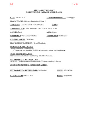
SITE PLAN REVIEW SHEET ENVIRONMENTAL VARIANCE REQUEST ONLY CASE: SP-2021-0178C PROJECT NAME: Stillwater - Double Creek Phase 2 APPLICANT: Lance Rosenfield, Michael Whellan ZAP COMMISSION DATE: dd/mm/yyyy AGENT: ADDRESS OF SITE: 10801 BREZZA LANE, AUSTIN, Texas, 78748 COUNTY: Travis WATERSHED: Onion Creek, Suburban EXISTING ZONING: CS-MU-CO AREA: 16 acres JURISDICTION: Full Purpose PROPOSED DEVELOPMENT: 371-unit Multifamily DESCRIPTION OF VARIANCE: The applicant requests the following: 1. Request to vary from LDC 25-8-261 to develop in a critical water quality zone. STAFF RECOMMENDATION: Staff recommends that the required findings of fact have been met. ENVIRONMENTAL BOARD ACTION: 11/21/2021: The Environmental Board voted in (X) favor, () against, () absentia ZONING AND PLATTING COMMISSION ACTION: ENVIRONMENTAL REVIEW STAFF: Mel Fuechec PHONE: 512-974-3036 CASE MANAGER: Clarissa Davis PHONE: 512-974-1423 1 of 34B-8 2 ENVIRONMENTAL COMMISSION MOTION 20211117 003a Date: November 17, 2021 Subject: Stillwater - Double Creek Phase 2, SP-2021-0178C Motion by: Kevin Ramberg Seconded by: Perry Bedford RATIONALE: WHEREAS, the Environmental Commission recognizes the applicant is requesting a variance from 25-8-261 to allow development in the Critical Water Quality Zone. WHEREAS, the Environmental Commission recognizes the site is located in the Onion Creek, Suburban Watershed and Desired Development Zone; and WHEREAS, the Environmental Commission recognizes that Staff recommends this variance, (with two staff conditions) having determined the required Findings of Fact have been met. THEREFORE, the Environmental Commission recommends the variance request with the following: Staff Conditions: 1. Internal low-traffic pedestrian walkways throughout the site shall be constructed with permeable pavers or porous pavement in accordance with the Environmental Criteria Manual, to decrease overall impervious cover and increase stormwater infiltration onsite and baseflow in the stream channel. 2. The critical water quality zone will be crossed with a span bridge design instead of the normal box culvert. This will allow for light to penetrate to the natural ground surface and for vegetation to grow thus maintaining a more natural stream channel. and the following Environmental Commission Conditions: 1. The project will use biofiltration in both water quality ponds onsite. 2. The pond will not occur in the inner half critical water quality zone. VOTE 8-0 For: Bedford, Qureshi, Thompson, Barrett Bixler, Bristol, Ramberg, Guerrero, and Brimer Against: None 1 Abstain: None 2 of 34B-8 3 Recuse: None Absent: Scott Approved By: Linda Guerrero, Environmental Commission Chair 3 of 34B-8 1 ENVIRONMENTAL COMMISSION MOTION 20211117 003a Date: November 17, 2021 Subject: Stillwater - Double Creek Phase 2, SP-2021-0178C Motion by: Kevin Ramberg RATIONALE: WHEREAS, the Environmental Commission recognizes the applicant is requesting a variance from 25-8-261 to allow development in the Critical Water Quality Zone. WHEREAS, the Environmental Commission recognizes the site is located in the Onion Creek, Suburban Watershed and Desired Development Zone; and Seconded by: Perry Bedford WHEREAS, the Environmental Commission recognizes that Staff recommends this variance, (with two staff conditions) having determined the required Findings of Fact have been met. THEREFORE, the Environmental Commission recommends the variance request with the following: Staff Conditions: 1. Internal low-traffic pedestrian walkways throughout the site shall be constructed with permeable pavers or porous pavement in accordance with the Environmental Criteria Manual, to decrease overall impervious cover and increase stormwater infiltration onsite and baseflow in the stream channel. 2. The critical water quality zone will be crossed with a span bridge design instead of the normal box culvert. This will allow for light to penetrate to the natural ground surface and for vegetation to grow thus maintaining a more natural stream channel. and the following Environmental Commission Conditions: 1. The project will use biofiltration in both water quality ponds onsite. 2. The pond will not occur in the inner half critical water quality zone. VOTE 8-0 For: Bedford, Qureshi, Thompson, Barrett Bixler, Bristol, Ramberg, Guerrero, and Brimer Against: None 4 of 34B-8 Abstain: None Recuse: None Absent: Scott Approved By: Linda Guerrero, Environmental Commission Chair 2 5 of 34B-8 ITEM FOR ENVIRONMENTAL COMMISSION AGENDA COMMISSION MEETING DATE: 11/17/2021 NAME & NUMBER OF PROJECT: Stillwater - Double Creek Phase 2 | SP-2021-0178C NAME OF APPLICANT OR ORGANIZATION: Lance Rosenfield, Malone Wheeler Inc LOCATION: 10801 Brezza Lane, Austin, Texas, 78748 COUNCIL DISTRICT: District 5 ENVIRONMENTAL REVIEW STAFF: Mel Fuechec, Environmental Review Specialist Senior, DSD - Land Use Review, 512-974-3036, mel.fuechec@austintexas.gov WATERSHED: REQUEST: Onion Creek, Suburban, Desired Development Zone Variance request is as follows: Request to vary from LDC 25-8-261 to allow development in the critical water quality zone. STAFF RECOMMENDATION: Staff recommends this variance, having determined the findings of fact to have been met. STAFF CONDITION: 1) Internal low-traffic pedestrian walkways throughout the site shall be constructed with permeable pavers or porous pavement in accordance with the Environmental Criteria Manual, to decrease overall impervious cover and increase stormwater infiltration onsite and baseflow in the stream channel. 2) The critical water quality zone will be crossed with a span bridge design instead of the normal box culvert. This will allow for light to penetrate to the natural ground surface and for vegetation to grow thus maintaining a more natural stream channel. 6 of 34B-8 A. Development Services Department Staff Recommendations Concerning Required Findings Project Name: Stillwater-Double Creek Phase 2 | SP-2021-0178C | 10801 Brezza Ln Ordinance Standard: Watershed Protection Ordinance Variance Request: Request to vary from LDC 25-8-261 to allow development in the critical water quality zone. Land Use Commission variance determinations from Chapter 25-8-41 of the City Code: 1. The requirement will deprive the applicant of a privilege or the safety of property given to owners of other similarly situated property with approximately contemporaneous development; The lot is zoned Commercial-Mixed Use, CS-MU-CO as are most of the Yes surrounding lots. A similar existing multifamily development built in 2017 is located directly North of the Stillwater – Double Creek Phase 2 project lot. Without a variance to LDC-25-8-261, the applicant is deprived a privilege to develop this property given to the owners of similarly situated property with approximately contemporaneous development. 2. The variance: a. Is not based on a condition caused by the method chosen by the applicant to develop the property, unless the development method provides greater overall environmental protection than is achievable without the variance; Yes The variance is necessitated by fire department ingress/egress requirements set forth in the International Fire Code and Wildland-Urban Interface. Two points of emergency ingress and egress are required, and AFD will not accept both to be on Brezza Lane which is currently a dead-end street. There is no other option for a second point of ingress/egress. b. Is the minimum change necessary to avoid the deprivation of a privilege given to other property owners and to allow a reasonable use of the property; and Yes As mentioned above, the variance is necessitated by the fire department requirement of having two points of emergency ingress/egress, which will be a bridge crossing and is considered a minimum deviation from the code. c. Does not create a significant probability of harmful environmental consequences; and 7 of 34B-8 Yes The proposed improvements related to the variance do not create a significant probability of harmful environmental consequences. The CWQZ will be crossed by a span bridge design instead of the normal box culvert. This will allow for light to penetrate to the natural ground surface and for vegetation to grow thus maintaining a more natural stream channel. 3. Development with the variance will result in water quality that is at least equal to the water quality achievable without the variance. Yes The variance will not decrease the overall water quality associated with the development. The plans will be fully code compliant for water quality treatment. The impervious cover limit in suburban watersheds is 60%; this project is proposing impervious cover of approximately 44%. Internal, low-traffic pedestrian paths will be constructed with permeable material to increase stormwater infiltration and baseflow in the stream channel. Developed runoff will be treated by the proposed onsite water quality ponds. The Land Use Commission may grant a variance from a requirement of Article 7, Division 1 ( Critical B. Water Quality Zone Restrictions ), after determining that: Additional Land Use Commission variance determinations for a requirement of Article 7, Division 1 (Critical Water Quality Zone Restrictions): 1. The criteria for granting a variance in Subsection (A) are met; Yes / No All criteria in Subsection A are met. 2. 3. The requirement for which a variance is requested prevents a reasonable, economic use of the entire property; Yes / No The proposed development is consistent with the applicable zoning and surrounding properties. Austin Fire Department requires two ingress/egress locations. Brezza Lane is not acceptable for both as it is a dead-end road with no immediate plans to be extended. The North end of the site is dense trees and is proposed to be preserved as parkland. No joint use access agreement with a neighboring property for ingress/egress through to I35 is feasible. The variance is the minimum deviation from the code requirement necessary to allow a reasonable, economic use of the entire property. Yes / No The variance is necessitated by the fire department requirement of having two points of emergency ingress/egress. The emergency ingress/egress proposed across the CWQZ will be a bridge crossing and is considered a minimum deviation from the code. Staff Determination: Staff determines that the findings of fact have been met. Staff recommends the following conditions: 1) Internal low-traffic pedestrian walkways throughout the site shall be constructed with permeable pavers or porous pavement in accordance with the Environmental Criteria Manual, 8 of 34B-8 to decrease overall impervious cover and increase stormwater infiltration onsite and baseflow in the stream channel. 2) The critical water quality zone will be crossed with a span bridge design instead of the normal box culvert. This will allow for light to penetrate to the natural ground surface and for vegetation to grow thus maintaining a more natural stream channel. Environmental Reviewer (DSD) Environmental Review Manager (DSD) Wetland Biologist / Hydrogeologist Reviewer (WPD) Deputy Environmental Officer (WPD) Mel Fuechec Mike McDougal (print name) _____________________________ (print name) Date:__10/21/2021______________ Date: 11-4-2021 Date ________________ Date 11/05/2021________ Liz Johnston (print name) 9 of 34B-8 ENVIRONMENTAL COMMISSION VARIANCE APPLICATION FORM November 10, 2021 Name of Applicant Street Address City State ZIP Code Work Phone E-Mail Address Case Name Case Number Address or Location Environmental Reviewer Name Environmental Resource Management Reviewer Name Applicable Ordinance PROJECT DESCRIPTION Applicant Contact Information Malone Wheeler Inc (Lance Rosenfield) 5113 SOUTHWEST PKWY, STE 260 AUSTIN TX 78735 512-899-0601 lancer@malonewheeler.com Variance Case Information Stillwater - Double Creek Phase 2 SP-2021-0178C 10801 BREZZA LN Mel Fuechec Andrew Clamann § 25-8-261 - CRITICAL WATER QUALITY ZONE DEVELOPMENT. Watershed Name Onion Creek Watershed Classification ☐Urban X Suburban ☐Water Supply Suburban ☐Water Supply Rural ☐ Barton Springs Zone City of Austin | Environmental Commission Variance Application Guide 1 10 of 34B-8 Edwards Aquifer Recharge Zone ☐ Barton Springs Segment ☐ Northern Edwards Segment X Not in Edwards Aquifer Zones ☐ Yes X No <100-FT Water and Waste Water service to be provided by AUSTIN WATER The variance request is as follows (Cite code references: Existing 0-SF 0-AC 0% Proposed 320,120-SF 7.35-AC 45.9% The subject site is 16.0-acres of undeveloped land that was previously cultivated for agricultural use. The land slopes at a relatively unform slope of approximately one percent (1%), from north to south, with an elevation range of 637 at the north end, down to 631 at the south end. Having been agricultural land, most of the site is free of trees, except for an area about 2.3-acres in size, comprising of primarily cedar, mesquite, and hackberry trees. Adjacent to the south property line, on the adjacent lot, is an uniform engineered earthen channel constructed in recent years, which is classified as a minor waterway with an associated floodplain (not yet defined) and CWQZ. The CWQZ extends onto the subject site. November 10, 2021 Edwards Aquifer Contributing Zone Distance to Nearest Classified Waterway Request Impervious cover square footage: acreage: percentage: Provide general description of the property (slope range, elevation range, summary of vegetation / trees, summary of the geology, CWQZ, WQTZ, CEFs, floodplain, heritage trees, any other notable or outstanding characteristics of the property) City of Austin | Environmental Commission Variance Application Guide 2 11 of 34B-8 November 10, 2021 Clearly indicate in what way the proposed project does not comply with current Code (include maps and exhibits) The proposed project includes a private drive crossing the engineered channel with a culvert system. The private drive makes the vehicular and emergency access connection to a public access easement ultimately connecting to the southbound I-35 access road. The crossing provides compliance with fire department criteria set forth in the Wildland-Urban Interface. Additionally, a water utility connection will be made within the CWQZ, adjacent to Brezza Lane. FINDINGS OF FACT As required in LDC Section 25-8-41, in order to grant a variance, the Land Use Commission must make the following findings of fact: Include an explanation with each applicable finding of fact. Project: Stillwater – Double Creek Phase 2 Ordinance: § 25-8-261 - CRITICAL WATER QUALITY ZONE DEVELOPMENT Land Use Commission variance determinations from Chapter 25-8-41 of the City Code: A. 1. The requirement will deprive the applicant of a privilege available to owners of similarly situated property with approximately contemporaneous development subject to similar code requirements. Yes / No The subject site is adjacent to the north of Double Creek Multifamily Phase 1, case number SP-2018-0403C, herein called “Phase 1.” Phase 1 is approved and under construction. The existing engineered channel triggering the CWQZ runs within and along the north property line of Phase 1. The approved site plan includes buildings, parking, fire lane, and paved access within the CWQZ. Is not necessitated by the scale, layout, construction method, or other design decision made by the applicant, unless the design decision provides greater overall environmental protection than is achievable without the variance; 2. The variance: a) Yes / No City of Austin | Environmental Commission Variance Application Guide 3 12 of 34B-8 November 10, 2021 The variance is necessitated by fire department ingress/egress requirements set forth in the International Fire Code and Wildland-Urban Interface. Two points of emergency ingress and egress are required, and AFD will not accept both to be on the dead end that is Brezza Lane. There is no other option for a second point of ingress/egress. Is the minimum deviation from the code requirement necessary to allow a reasonable use of the property; As mentioned above, the variance is triggered by the fire department requirement of having two points of emergency ingress/egress, which will be a culvert crossing and is considered a minimum deviation from the code. Does not create a significant probability of harmful environmental consequences. Yes / No Yes / No b) c) The proposed improvements related to the variance do not create a significant probability of harmful environmental consequences. 3. Development with the variance will result in water quality that is at least equal to the water quality achievable without the variance. Yes / No The variance will not decrease the water quality treatment associated with the improvements. The plans will be fully code compliant for water quality treatment. Additional Land Use Commission variance determinations for a requirement of Section 25-8-422 (Water Quality Transition Zone), Section 25-8-452 (Water Quality Transition Zone), Article 7, Division 1 (Critical Water Quality Zone Restrictions), or Section 25-8-368 (Restrictions on Development Impacting Lake Austin, Lady Bird Lake, and Lake Walter E. Long): The criteria for granting a variance in Subsection (A) are met; Yes / No [provide summary of justification for determination] The requirement for which a variance is requested prevents a reasonable, economic use of the entire property; Yes / No [provide summary of justification for determination] City of Austin | Environmental Commission Variance Application Guide 4 1. 2. B. 13 of 34B-8 November 10, 2021 3. The variance is the minimum deviation from the code requirement necessary to allow a reasonable, economic use of the entire property. Yes / No [provide summary of justification for determination] **Variance approval requires all above affirmative findings. City of Austin | Environmental Commission Variance Application Guide 5 14 of 34B-8 Site Summary Variance Request for Double Creek Multifamily Phase 2 (SP-2021-0178C) August 31, 2021 Environmental Commission and Land Use Commission City of Austin 301 W 2nd Street Austin, Texas 78701 Re: Dear Commissioners, In order to provide safe emergency access and with minimal disturbance, a variance to Land Development Code § 25-8-261, which limits development in a critical water quality zone, is hereby requested for Double Creek Multifamily Phase 2 site plan (case number SP-2021-0178C) and the related off-site water main improvements per SER-4280. I. The Double Creek Multifamily Phase 2 project is located approximately 1,300-ft north of the intersection of E FM 1626 Rd and Old San Antonio Road, and is on Lot 3 of Double Creek Subdivision, Section 2, Austin, Travis County, and is in the City’s full purpose jurisdiction. The site is zoned CS-MU-CO, per zoning case number C14-03-0053. The project will consist of 371 multifamily units in three to four-story buildings, with surface and garage parking. Water quality ponds, driveway and fire access, utilities, grading, sidewalks, landscaping, approximately 5.5-acres of parkland dedication, and a culvert crossing will be included. The site is 16.00 acres, with right-of-way frontage along Brezza Lane, for which road improvements are currently under construction (SP-2019-0161D). One point of driveway access will be on Brezza Lane. The site will also have access from I-35 via a private drive currently under construction with the site plan Double Creek Multifamily (SP-2018-0403C) and Private Roadway easement doc. no. 2018093713 and a proposed joint use access easement of similar alignment. The private drive will provide access the subject site via a proposed culvert crossing over an existing engineered channel. The property is in the Onion Creek watershed, which is classified as a Suburban Watershed, and is outside of the Edwards Aquifer Recharge Zone. No portion of the site is within the 100-year floodplain, per FEMA map number 48453C0595k, dated January 22, 2020. The site is currently undeveloped with existing impervious cover of 0%, and the proposed impervious cover is less than 50% of the site area. The site currently surface drains from north to south and developed runoff will be treated with proposed water quality ponds and discharge into an existing engineered channel along the south boundary of the site. 5113 Southwest Parkway, Suite 260, Austin, Texas 78735 T: 512.899.0601 Firm Registration No. F-786 www.malonewheeler.com 15 of 34B-8 During the completeness check review for Double Creek Phase 2, the City provided a comment report in June 2021 in which it was stated that a critical water quality zone is delineated about the engineered channel that was constructed in recent years (dates provided in the timeline in Part II below). Emergency and tenant vehicle access to the site is proposed with a culvert crossing over the channel. A portion of a proposed public water main as required by SER-4280 and a water meter will be within 50-ft of the centerline of the channel. These improvements would not explicitly be in compliance with LDC 25-8-261. II. Variance The basis for the variance request and substantiation for its approval is as follows: A. Under § 25-8-41 Land Use Commission Variances, the following apply 1. Subsequent to the construction of the engineered channel, which was permitted in July 2015 under case number SP-2014-0103D “Stablewood Box Culvert,” two site plans in the immediate vicinity were approved and permitted without identifying the artificially engineered channel as a critical water quality zone: i. ii. Double Creek Multifamily Phase 1 (SP-2018-0403C) Brezza Lane Improvements (SP-2019-0161D) The two projects listed above include substantial improvements in the critical water quality zone, including apartment buildings, pavement for parking, utilities, and public roadway. Therefore, under § 25-8-41 Land Use Commission Variances, the requirement will deprive the applicant of a privilege available to owners of other similarly situated property with approximately contemporaneous development subject to similar code requirements. 2. The variance: (a) is not necessitated by the scale, layout, construction method, or other design decision made by the applicant, unless the design decision provides greater overall environmental protection than is achievable without the variance; (b) is the minimum deviation from the code requirement necessary to allow a reasonable use of the property; and (c) does not create a significant probability of harmful environmental consequences; and 3. The surface run-off from the improvements will be treated with city standard water quality facilities and is therefore equal to the water quality achievable without the variance. Additional Substantiation 1. Austin Fire Department requires two points of ingress and egress. The applicant met with AFD on 3/17/2021 and has had follow up correspondence via email, from which the following statements were provided by AFD explaining the code related to the requirement: B. Firm Registration No. F-786 www.malonewheeler.com 16 of 34B-8 Brezza Lane is a dead-end street and the project is located directly in a Wildland Urban Interface (WUI) area which is susceptible to wildfires making fire access and evacuation of the development critical during a structure fire or wildfire event. 2015 IFC: 503.1.2 Additional access. The fire code official is authorized to require more than one fire apparatus access road based on the potential for impairment of a single road by vehicle congestion, condition of terrain, climatic conditions or other factors that could limit access. 2015 Wildland Urban Interface Code Amendments (these direct you back to the fire code). 402.1.1 Access. A subdivision described in City Code Chapter 25-4 (Subdivision) that is located within in a wildland-urban interface area and platted after the effective date of this code must provide fire apparatus access roads that comply with the Fire Code. 403.3 Fire Apparatus Access Road. When required, a fire apparatus access road must Comply with the Fire Code. 2. Timeline of key dates described herein: • • • • July 2015: Stablewood Box Culvert project receives permit (SP-2014-0103D). Construction of the engineered channel begins. See the attached excerpt from the culvert plans, showing the location of the channel improvements. • March 2019: Water SER-4280 is provided by Austin Water, which includes a water service connection and public improvements in the buffer area defined by the CWQZ. SER-4280 is included as an attachment. June 2019: Double Creek Multifamily Phase 1 receives permit (SP-2018-0403C) with meaningful improvements such as buildings and parking within the recently identified critical water quality zone. The Phase 1 Overall Site Plan is enclosed. • August 2020: Brezza Lane Improvement Plans receive permit (SP-2019-0161D) with the portions of the public roadway now in the critical water quality zoned created by the human-constructed channel. June 2021: The CWQZ delineation is brought to our attention via the site plan completeness check comments. July 2021: Site Plan submitted formally to the City (SP-2021-0178C) with no buildings within the recently identified CWQZ. Firm Registration No. F-786 www.malonewheeler.com 17 of 34B-8 • August 2021: Applicant revised the site plan to further minimize encroachment, specifically removing parking from the CWQZ; the only remaining improvements within the recently-identified CWQZ are the required bridge for emergency services and the water meter that is required by the Service Extension Request. III. Conclusion In response to the City’s determination of the critical water quality zone, the applicant has modified the site plan to remove 27 parking spaces and shifted utilities away from the engineered channel to the fullest extent practical. Taken in the aggregate, this variance request is logical and reasonable, and will create an outcome that meets the criteria set forth in § 25-8-41 Land Use Commission Variances, and will meet the requirements set forth by Austin Fire Department. Sincerely, Malone Wheeler, Inc. Lance Rosenfield, P.E. Senior Project Manager Firm Registration No. F-786 www.malonewheeler.com Enclosures:1. Completed Variance Application2. Application Exhibit 1a - Aerial Photo3. Application Exhibit 1b - Aerial Photo4. Application Exhibit 2 - Site Photos5. Application Exhibit 3 - Vicinity and Context Map6. Application Exhibit 4 - Topo and Tree List7. Application Exhibit 5 - Revised Site Plan8. Application Exhibit 6 - Aerial Photo with CWQZ9. Application Exhibit 7 - ERI by Terracon10. Supplemental Exhibit 1 - AFD Written Requirement (email)11. Supplemental Exhibit 2 - SER-4280 for Water12. Supplemental Exhibit 3 - Approved Site Plan "Phase 1"13. Supplemental Exhibit 4 - Approved Brezza Lane Excerpt Sheets18 of 34B-8 Legend Jurisdiction FULL PURPOSE LIMITED PURPOSE OTHER CITY LIMITS OTHER CITIES ETJ Lot Line Jurisdiction FULL PURPOSE LIMITED PURPOSE OTHER CITY LIMITS OTHER CITIES ETJ Creek Centerlines Lakes EXTRATERRITORIAL JURISDICTION 2 MILE ETJ AGRICULTURAL AGREEMENT EXTRATERRITORIAL JURISDICTION 2 MILE ETJ AGRICULTURAL AGREEMENT 0.1 0 0.04 0.1 Miles NAD_1983_StatePlane_Texas_Central_FIPS_4203_Feet August 27, 2021 This product is for informational purposes and may not have been prepared for or be suitable for legal, engineering, or surveying purposes. It does not represent an on-the-ground survey. This product has been produced by the City of Austin for the sole purpose of geographic reference. No warranty is made by the City of Austin regarding specific accuracy or completeness. 1: 2,400 Notes Aerial Image of Undeveloped Site for "Double Creek Phase 2" 19 of 34B-8 Legend Jurisdiction FULL PURPOSE LIMITED PURPOSE OTHER CITY LIMITS OTHER CITIES ETJ Jurisdiction FULL PURPOSE LIMITED PURPOSE OTHER CITY LIMITS OTHER CITIES ETJ Creek Centerlines Lakes EXTRATERRITORIAL JURISDICTION 2 MILE ETJ AGRICULTURAL AGREEMENT EXTRATERRITORIAL JURISDICTION 2 MILE ETJ AGRICULTURAL AGREEMENT 0.3 0 0.15 0.3 Miles NAD_1983_StatePlane_Texas_Central_FIPS_4203_Feet August 27, 2021 1: 9,600 Notes Context Map This product is for informational purposes and may not have been prepared for or be suitable for legal, engineering, or surveying purposes. It does not represent an on-the-ground survey. This product has been produced by the City of Austin for the sole purpose of geographic reference. No warranty is made by the City of Austin regarding specific accuracy or completeness. I-35AKINS HIGHSCHOOLDBL CRKPH.1FM 1626COLONIALGRAND APTSBELL SOUTHPARKAPTSVOLKSWAGONDEALERSHIPFUTUREMERCEDESDEALERSHIPONION CREEKSUBDIVISIONMEADOWS ATDOUBLE CREEK(SINGLE FAMILYHOMES)20 of 34B-8 Legend Jurisdiction FULL PURPOSE LIMITED PURPOSE OTHER CITY LIMITS OTHER CITIES ETJ Lot Line Jurisdiction FULL PURPOSE LIMITED PURPOSE EXTRATERRITORIAL JURISDICTION 2 MILE ETJ AGRICULTURAL AGREEMENT EXTRATERRITORIAL JURISDICTION 2 MILE ETJ AGRICULTURAL AGREEMENT OTHER CITY LIMITS OTHER CITIES ETJ Creek Buffers/Waterway Setbacks Critical Water Quality Zone Water Quality Transition Zone Creek Centerlines Lakes 0.2 0 0.08 0.2 Miles NAD_1983_StatePlane_Texas_Central_FIPS_4203_Feet August 27, 2021 This product is for informational purposes and may not have been prepared for or be suitable for legal, engineering, or surveying purposes. It does not represent an on-the-ground survey. This product has been produced by the City of Austin for the sole purpose of geographic reference. No warranty is made by the City of Austin regarding specific accuracy or completeness. 1: 4,800 Notes Aerial Image of "Double Creek Phase 2" Site and Critical Water Quality Zone 21 of 34B-8 C.O.A. EX.WW MANHOLE GIS# 123778 INV. IN: 615.72 INV. OUT: 615.62 W W 8 " PVC SDR 2 6 WW ( 9 9 - 0 0 3 3 ) W W W W 15' WASTEWATER LINE EASEMENT DOC. NO. 1999117975 637 8 " PVC SDR 2 6 WW ( 9 9 - 0 0 3 3 ) W W W W 6 3 7 W W ZONE: I-RR USE: SCHOOL LOT: ABS 24 DELVALLE S ACR 12.263 OWNER:AUSTIN INDEPENDENT SCHOOL W W W W 15' ELECTRIC DISTRIBUTION, ELECTRIC TELECOMMUNICATIONS AND ELECTRIC FIBER EASEMENT BY PLAT # 201900171 OPRTCT LO-MU-CO ZONING: USE: COMMERCIAL LOT:TRACT A MORRIS DALE SUBDIVISION BK. 14, PG.17 OWNER:WESTIE ENTERPRISES LLC ZON: I-RR USE: SINGLE FAMILY RESIDENTIAL LOT: TRACT B MORRIS DALE SUBDIVISION BK. 14, PG.17 OWNER:NOMBRANA JOHN C & SELMA R B R E Z Z A L A N E 15' ELECTRIC DISTRIBUTION, ELECTRIC TELECOMMUNICATIONS AND ELECTRIC FIBER EASEMENT BY PLAT # 201900171 OPRTCT STERLING/BABCOCK & BROWN DOUBLE CREEK LP (24.532 AC) DOC. NO. 2008006671 CS-CO ZONING: USE: AUTO PARTS STORE LOT: 4.1735 AC OF LOT A MARSHAL RICHARD ADDN OWNER: KMA BROKERAGE & DEVELOPMENT INC. 6 3 7 637 C.O.A. EX.WW MANHOLE GIS# 123787 INV. IN: 617.69 INV. OUT: 617.59 636 6 3 5 6 3 4 6 3 3 632 631 X X X X X X X X X X X X X X X X X X X X X X X X X X C.O.A. EX.WW MANHOLE GIS# 123792 INV. IN: 619.98 INV. OUT: 619.88 15' WASTEWATER LINE EASEMENT DOC. NO. 1999117975 ) 3 3 0 0 - 9 9 ( W W 6 2 R W W D S C V P " 8 CS-CO ZONING: USE: UNDELVOPED LOT: LOT A MARSHAL RICHARD ADDN OWNER: BARNETT I-10 REALITY INC. C.O.A. EX.WW MANHOLE GIS# 123799 INV. IN: 621.02 INV. OUT: 620.92 8" PVC SDR 26 WW (99-0033) W W CS-CO ZONING: USE: AUTOMOTIVE DEALERSHIP LOT: LOT 1 BERNETT SUBDIVISION DOC. NO. 201200162 O.P.R.T.C.T. OWNER: BARNETT AUSTIN REALITY LTD DRAINAGE EASEMENT DOC. NO. 2015101091 O.P.R.T.C.T CWQZ O L D S A N A N T ZONE: SF-2 USE: SINGLE FAMILY RESIDENTIAL LOT: ABS 20 SUR 1 SLAUGHTER S F ACR 0.4100 ABS 24 DELVALLE S ACR 0.4000(0.808 AC) DOC. NO. 2011164494 OWNER: WILKINS ROBERT O E OE O E O E O E O E O E O N I O R D E O . O E O E E O W W E O O E E O E O E O E O E O E O THE CITY OF AUSTIN (2.730 AC-TRACT 1) DOC. NO. 2015046419 E O E O E O W W E O E O E O E O E O E O E O E O 10' CITY OF AUSTIN SIDEWALK EASEMENT DEDICATED BY PLAT DOC. NO. 201900171 O.P.R.T.C.T. DRAINAGE EASEMENT DOC. NO. 2015101091 O.P.R.T.C.T C.O.A. PROP.WW MANHOLE ( 2 0 2 1 - 0 5 5 0 ) GIS# 299618 INV. IN: 619.33 INV. OUT: 619.23 CS-MU-CO ZONING: USE: MF LOT: LOT 2 DOUBLE CREEK PARK SUBDIVISION, SECTION 2 NO. 201900171 O.P.R.T.C.T. OWNER: SW DOUBLE CREEK DEVELOPMENT LLC 630 25' WATER & WASTEWATER EASEMENT DEDICATED BY PLAT DOC. NO. 201900171 O.P.R.T.C.T. 15' WATER LINES EASEMENT DOC. NO. 2019170632 O.P.R.T.C.T. 15' WATER LINES EASEMENT DOC. NO. 2019170632 O.P.R.T.C.T. PUBLIC ACCESS EASEMENT DEDICATED BY PLAT DOC. NO. 201900171 O.P.R.T.C.T. LOT 1 DOUBLE CREEK PARK SUBDIVISION, SECTION 1 NO. 201700263 P.R.T.C.T. ZONING: CS-CO USE: UNDEVELOPED DESIGN BY : CHECKED BY : APPROVED BY : ? ? ? DATE : 7/13/2021 SHEET 58 OF 06 SP-2021-0178C Y B I N O S V E R I E T A D . O N N 00 60' SCALE: 1" = 60' LEGEND PROPERTY BOUNDARY EXIST. CHAIN LINK FENCE EXIST. WATER LINE EXIST. WASTEWATER LINE EXIST. STORM LINE EXIST. GAS LINE OE UE GAS UT OE UE EXIST. OVERHEAD ELECTRIC EXIST. UNDERGROUND ELECTRIC EXIST. UNDERGROUND TELEPHONE 1/2" REBAR FOUND (OR AS NOTED) 1/2" REBAR WITH "EARLY BOUNDARY" CAP SET MAG NAIL FOUND MAG NAIL WITH "EARLY BOUNDARY" WASHER SET C BENCHMARK/CONTROL POINT AIR CONDITIONER BOLLARD CLEANOUT HANDICAP PARKING MAILBOX ELECTRIC UTILITY FIRE DEPARTMENT CONNECTION FIRE HYDRANT WATER VALVE WATER METER UNDERGROUND GAS MARKER GAS UTILITY LIGHT POLE UTILITY POLE GUY WIRE SIGN SEPTIC TANK LID ELECTRIC MANHOLE STORMSEWER MANHOLE TELECOM MANHOLE IRRIGATION VALVE ELECTRICAL JUNCTION BOX F UNDERGROUND FIBER MARKER TELECOM UTILITY WASTEWATER MANHOLE EDGE OF ASPHALT PAVEMENT B.L. ( ) BUILDING SETBACK LINE RECORD INFORMATION TELEPHONE SERVICE BOX CONTROL POINT AERIAL TARGET I I I I E S A H P Y L M A F T L U M K E E R C E L B U O D 8 4 7 8 7 X T , I N T S U A . N L A Z Z E R B 1 0 8 0 1 I I S N O T D N O C G N T S X E I I 5 9 9 1 . C N I E C N S I T N E M E G A N A M T C E J O R P G N I T L U S N O C T N E M P O L E V E D I G N R E E N G N E I I L V C I 0 6 2 e t i u S , y w k P t s e w h t u o S 3 1 1 5 5 3 7 8 7 s a x e T , n i t s u A 5 5 6 0 - 9 9 8 ) 2 1 5 ( : x a F 1 0 6 0 - 9 9 8 ) 2 1 5 ( : e n o h P 6 8 7 - F . o N n o i t a r t s i g e R m r i F S E M A J , I I M P 7 4 : 6 5 : 0 1 1 2 0 2 / 4 1 / 7 , g w d . S N O T D N O C G N T S X E 6 0 \ t e s n a P \ s g n w a r D S U A - 5 2 0 - 0 2 I I \ i l j \ \ s t c e o r P 2 h P k e e r C e b u o D – r e t a w l l l i t S \ : F Y O C C M S E M A J , 1 2 0 2 / 4 1 / 7 , . I I I \ \ I I G W D S N O T D N O C G N T S X E 6 0 \ T E S N A L P S G N W A R D S U A - 5 2 0 - 0 2 \ S T C E J O R P \ 2 H P K E E R C E L B U O D – R E T A W L L T S I \ : F 22 of 34B-8 TREES 45-58, 60 & 62 TO BE REMOVED PER (SP-2019-0161D) Y O C C M S E M A J , 1 2 0 2 / 4 1 / 7 , I . \ \ G W D T S I L E E R T 7 0 \ T E S N A L P S G N W A R D S U A - 5 2 0 - 0 2 \ S T C E J O R P \ 2 H P K E E R C E L B U O D – R E T A W L L T S I \ : F Y B I N O S V E R I E T A D . O N I I I I E S A H P Y L M A F T L U M K E E R C E L B U O D 8 4 7 8 7 X T , I N T S U A . N L A Z Z E R B 1 0 8 0 1 I T S L E E R T 5 9 9 1 . C N I E C N S I T N E M E G A N A M T C E J O R P G N I T L U S N O C T N E M P O L E V E D I G N R E E N G N E I I L V C I 0 6 2 e t i u S , y w k P t s e w h t u o S 3 1 1 5 5 3 7 8 7 s a x e T , n i t s u A 5 5 6 0 - 9 9 8 ) 2 1 5 ( : x a F 1 0 6 0 - 9 9 8 ) 2 1 5 ( : e n o h P 6 8 7 - F . o N n o i t a r t s i g e R m r i F S E M A J , M P 4 5 : 6 5 : 0 1 1 2 0 2 / 4 1 / 7 , g w d . T S I L E E R T 7 0 \ t e s n a P \ s g n w a r D S U A - 5 2 0 - 0 2 \ i l j \ \ s t c e o r P 2 h P k e e r C e b u o D – r e t a w l l l i t S \ : F DESIGN BY : CHECKED BY : APPROVED BY : ? ? ? DATE : 7/12/2021 SHEET 58 OF 07 SP-2021-0178C 23 of 34B-8 NOTES GENERAL NOTES: 1. THIS BRIDGE HAS BEEN DESIGNED FOR GENERAL SITE CONDITIONS. THE PROJECT ENGINEER SHALL BE RESPONSIBLE FOR THE STRUCTURE'S SUITABILITY TO THE EXISTING SITE CONDITIONS AND FOR THE HYDRAULIC EVALUATION --INCLUDING SCOUR AND CONFIRMATION OF SOIL CONDITIONS. 2. PRIOR TO CONSTRUCTION, CONTRACTOR MUST VERIFY ALL ELEVATIONS SHOWNTHROUGH THE ENGINEER. 3. ONLY CONTECH ENGINEERED SOLUTIONS LLC, THE CON/SPANⓇ APPROVED PRECASTER IN TEXAS MAY PROVIDE THE STRUCTURE DESIGNED IN ACCORDANCE WITH THESE PLANS. 4. THE USE OF ANOTHER PRECAST STRUCTURE WITH THE DESIGN ASSUMPTIONS USED FOR THE CON/SPANⓇ STRUCTURE MAY LEAD TO SERIOUS DESIGN ERRORS. USE OFANY OTHER PRECAST STRUCTURE WITH THIS DESIGN AND DRAWINGS VOIDS ANY CERTIFICATION OF THIS DESIGN AND WARRANTY. CONTECH Engineered Solutions, LLC ASSUMES NO LIABILITY FOR DESIGN OF ANYALTERNATE OR SIMILAR TYPE STRUCTURES. 5. ALTERNATE STRUCTURES MAY BE CONSIDERED, PROVIDED THAT DRAWINGS AND CALCULATIONS SIGNED AND SEALED BY A PROFESSIONAL ENGINEER, REGISTERED IN THE STATE OF TEXAS, EMPLOYED BY THE PRECAST CONCRETE BRIDGE SUPPLIER, ARE SUBMITTED TO THE ENGINEER 2 WEEKS PRIOR TO THE BID DATE FOR REVIEW AND APPROVAL. 6. ALTERNATE STRUCTURES MAY BE CONSIDERED, PROVIDED THAT THE ALTERNATE DESIGN DOES NOT REDUCE THE HYDRAULIC OPENING OF THE STRUCTURE AS SHOWN ON THE DRAWINGS. AT A MINIMUM THE ALTERNATE STRUCTURE MUST PROVIDE THE SAME OR LARGER SPAN AND RISE AS THE STRUCTURE SHOWN ON THE DRAWINGS. 7. THE PRECAST ARCH SUPPLIER MUST ATTEND THE PRE-BID MEETING, IF ONE IS HELD. 8. SUPPLIER OF PROPOSED ALTERNATES TO A CON/SPANⓇ BRIDGE SYSTEM MUST SUBMIT AT LEAST TWO (2) INDEPENDENTLY VERIFIED FULL SCALE LOAD TESTS THAT CONFIRM THE PROPOSED DESIGN METHODOLOGY OF THE THREE SIDED/ARCH STRUCTURE(S). THE PROPOSED ALTERNATE, UPON SATISFACTORY CONFIRMATION OF DESIGN METHODOLOGY, MAY BE CONSIDERED AN ACCEPTABLE ALTERNATE. 9. PROPOSED ALTERNATE STRUCTURES MAY BE CONSIDERED, PROVIDED THAT THE PRECAST CONCRETE BRIDGE STRUCTURES ARE PROVIDED BY A SUPPLIER THAT HAS A MINIMUM OF TWO (2) REGISTERED PROFESSIONAL ENGINEERS ON STAFF THAT ARE DEDICATED TO THE DESIGN OF THESE TYPES OF STRUCTURES. SUPPLIER MUST PROVIDE THESE NAMES, P.E. LICENSE NUMBERS AND DATES OF HIRE AT TIME OF ALTERNATE SUBMITTAL. DESIGN DATA DESIGN LOADING: BRIDGE UNITS: HL-93 HEADWALLS: EARTH PRESSURE ONLY WINGWALLS: EARTH PRESSURE ONLY DESIGN FILL HEIGHT: 1'-0" TO 4'-0" FROM TOP OF CROWN TO TOP OF PAVEMENT. DESIGN METHOD: LOAD RESISTANCE FACTOR DESIGN PER AASHTO LRFD SPECIFICATION ASSUMED NOMINAL BEARING RESISTANCE: 0 PSF ASSUMED FACTORED BEARING RESISTANCE: 0 PSF *AT THE TIME OF DESIGN, A GEOTECHNICAL REPORT FOR THE PROJECT SITE WAS NOT AVAILABLE. IT IS THE PROJECT ENGINEER'S, OWNER'S AND/OR THE CONTRACTOR'S RESPONSIBILITY TO VERIFY THAT THE ACTUAL SITE CONDITIONS AT THE TIME OF CONSTRUCTION ARE CONSISTENT WITH THE ASSUMED ALLOWABLE SOIL BEARING PRESSURE WITH A GEOTECHNICAL INVESTIGATION FROM A QUALIFIED GEOTECHNICAL ENGINEER. MATERIALS PRECAST UNITS SHALL BE CONSTRUCTED AND INSTALLED IN ACCORDANCE WITH CON/SPAN® SPECIFICATIONS. CONCRETE FOR FOOTINGS SHALL HAVE A MINIMUM COMPRESSIVE STRENGTH OF 4000 PSF. REINFORCING STEEL FOR FOOTINGS SHALL CONFORM TO ASTM A615 OR A996-GRADE 60. W 1 I N 1'- G W 6 " A L L 2 C B 36'-0" (OUT TO OUT) N A P S " 0 - ' 3 3 A A W IN G W ALL 4 11'-6" C B CL W 1 I N 1'- G W 6 " A L L 3 W IN G W ALL 1 11'-6" BRIDGE PLAN The design and information shown on this drawing is provided as a service to the project owner, engineer and contractor by CONTECH Engineered Solutions LLC ('CONTECH'). Neither this drawing, nor any part thereof, may be used, reproduced or modified in any manner without the prior written consent of CONTECH. Failure to comply is done at the user's own risk and CONTECH expressly disclaims any liability or responsibility for such use. If discrepancies between the supplied information upon which the drawing is based and actual field conditions are encountered as site work progresses, these discrepancies must be reported to CONTECH immediately for re-evaluation of the design. CONTECH accepts no liability for designs based on missing, incomplete or inaccurate information supplied by others. MARK DATE REVISION DESCRIPTION BY 9025 Centre Pointe Dr., Suite 400, West Chester, OH 45069 800-338-1122 513-645-7000 513-645-7993 FAX PROPOSAL DRAWING CONSPAN O SERIES O633 - 33'-0" X 6'-4" MALONE WHEELER CHANNEL CROSSING AUSTIN, TEXAS PRELIMINARY NOT FOR CONSTRUCTION Seq No.: 010 Date: 9/9/2021 Drawn: Project No.: 688751 Designed: JJM Sheet No.: Checked: Approved: 1 OF 10 24 of 34B-8 E S I R " 4 - ' 6 T/GRADE " 0 - ' 1 R A E L C " 4 / 1 4 - ' 6 FLOW LINE 33'-0" SPAN CROSS SECTION A-A Approximate Area: 163 sq. ft. used, 163 sq. ft. total The design and information shown on this drawing is provided as a service to the project owner, engineer and contractor by CONTECH Engineered Solutions LLC ('CONTECH'). Neither this drawing, nor any part thereof, may be used, reproduced or modified in any manner without the prior written consent of CONTECH. Failure to comply is done at the user's own risk and CONTECH expressly disclaims any liability or responsibility for such use. If discrepancies between the supplied information upon which the drawing is based and actual field conditions are encountered as site work progresses, these discrepancies must be reported to CONTECH immediately for re-evaluation of the design. CONTECH accepts no liability for designs based on missing, incomplete or inaccurate information supplied by others. MARK DATE REVISION DESCRIPTION BY 9025 Centre Pointe Dr., Suite 400, West Chester, OH 45069 800-338-1122 513-645-7000 513-645-7993 FAX PROPOSAL DRAWING CONSPAN O SERIES O633 - 33'-0" X 6'-4" MALONE WHEELER CHANNEL CROSSING AUSTIN, TEXAS PRELIMINARY NOT FOR CONSTRUCTION Seq No.: 010 Date: 9/9/2021 Drawn: Project No.: 688751 Designed: JJM Sheet No.: Checked: Approved: 2 OF 10 25 of 34B-8 1'-5" 1'-5" " 0 - ' 2 1'-2" 4'-0" TYPICAL FOOTING DETAIL NOTES • FOOTING DIMENSIONS AND DETAILS SHOWN ARE CONCEPTUAL ONLY • FINAL DIMENSIONS & DETAILS TO BE FURNISHED BY THE PROJECT ENGINEERS • FOUNDATION REINFORCING TO BE DETERMINED The design and information shown on this drawing is provided as a service to the project owner, engineer and contractor by CONTECH Engineered Solutions LLC ('CONTECH'). Neither this drawing, nor any part thereof, may be used, reproduced or modified in any manner without the prior written consent of CONTECH. Failure to comply is done at the user's own risk and CONTECH expressly disclaims any liability or responsibility for such use. If discrepancies between the supplied information upon which the drawing is based and actual field conditions are encountered as site work progresses, these discrepancies must be reported to CONTECH immediately for re-evaluation of the design. CONTECH accepts no liability for designs based on missing, incomplete or inaccurate information supplied by others. MARK DATE REVISION DESCRIPTION BY 9025 Centre Pointe Dr., Suite 400, West Chester, OH 45069 800-338-1122 513-645-7000 513-645-7993 FAX PROPOSAL DRAWING CONSPAN O SERIES O633 - 33'-0" X 6'-4" MALONE WHEELER CHANNEL CROSSING AUSTIN, TEXAS PRELIMINARY NOT FOR CONSTRUCTION Seq No.: 010 Date: 9/9/2021 Drawn: Project No.: 688751 Designed: JJM Sheet No.: Checked: Approved: 3 OF 10 26 of 34B-8 " 4 / 1 1 - ' 8 2 L L A W G N W I " 0 - ' 4 " 0 - ' 2 " 4 / 1 1 - ' 8 1 L L A W G N W I " 0 - ' 4 " 0 - ' 2 38'-4" HEADWALL " 0 - ' 1 E S I R " 4 - ' 6 29'-8" 33'-0" SPAN INLET END ELEVATION The design and information shown on this drawing is provided as a service to the project owner, engineer and contractor by CONTECH Engineered Solutions LLC ('CONTECH'). Neither this drawing, nor any part thereof, may be used, reproduced or modified in any manner without the prior written consent of CONTECH. Failure to comply is done at the user's own risk and CONTECH expressly disclaims any liability or responsibility for such use. If discrepancies between the supplied information upon which the drawing is based and actual field conditions are encountered as site work progresses, these discrepancies must be reported to CONTECH immediately for re-evaluation of the design. CONTECH accepts no liability for designs based on missing, incomplete or inaccurate information supplied by others. MARK DATE REVISION DESCRIPTION BY 9025 Centre Pointe Dr., Suite 400, West Chester, OH 45069 800-338-1122 513-645-7000 513-645-7993 FAX PROPOSAL DRAWING CONSPAN O SERIES O633 - 33'-0" X 6'-4" MALONE WHEELER CHANNEL CROSSING AUSTIN, TEXAS PRELIMINARY NOT FOR CONSTRUCTION Seq No.: 010 Date: 9/9/2021 Drawn: Project No.: 688751 Designed: JJM Sheet No.: Checked: Approved: 4 OF 10 27 of 34B-8 " 4 / 1 1 - ' 8 3 L L A W G N W I " 0 - ' 4 " 0 - ' 2 " 4 / 1 1 - ' 8 4 L L A W G N W I " 0 - ' 4 " 0 - ' 2 38'-4" HEADWALL " 0 - ' 1 E S I R " 4 - ' 6 29'-8" 33'-0" SPAN OUTLET END ELEVATION The design and information shown on this drawing is provided as a service to the project owner, engineer and contractor by CONTECH Engineered Solutions LLC ('CONTECH'). Neither this drawing, nor any part thereof, may be used, reproduced or modified in any manner without the prior written consent of CONTECH. Failure to comply is done at the user's own risk and CONTECH expressly disclaims any liability or responsibility for such use. If discrepancies between the supplied information upon which the drawing is based and actual field conditions are encountered as site work progresses, these discrepancies must be reported to CONTECH immediately for re-evaluation of the design. CONTECH accepts no liability for designs based on missing, incomplete or inaccurate information supplied by others. MARK DATE REVISION DESCRIPTION BY 9025 Centre Pointe Dr., Suite 400, West Chester, OH 45069 800-338-1122 513-645-7000 513-645-7993 FAX PROPOSAL DRAWING CONSPAN O SERIES O633 - 33'-0" X 6'-4" MALONE WHEELER CHANNEL CROSSING AUSTIN, TEXAS PRELIMINARY NOT FOR CONSTRUCTION Seq No.: 010 Date: 9/9/2021 Drawn: Project No.: 688751 Designed: JJM Sheet No.: Checked: Approved: 5 OF 10 28 of 34B-8 " 4 / 1 1 - ' 8 3 L L A W G N W I " 0 - ' 4 " 4 / 1 1 - ' 8 1 L L A W G N W I " 0 - ' 4 E S I R " 4 - ' 6 36'-0" (OUT TO OUT) PROFILE SECTION B-B The design and information shown on this drawing is provided as a service to the project owner, engineer and contractor by CONTECH Engineered Solutions LLC ('CONTECH'). Neither this drawing, nor any part thereof, may be used, reproduced or modified in any manner without the prior written consent of CONTECH. Failure to comply is done at the user's own risk and CONTECH expressly disclaims any liability or responsibility for such use. If discrepancies between the supplied information upon which the drawing is based and actual field conditions are encountered as site work progresses, these discrepancies must be reported to CONTECH immediately for re-evaluation of the design. CONTECH accepts no liability for designs based on missing, incomplete or inaccurate information supplied by others. MARK DATE REVISION DESCRIPTION BY 9025 Centre Pointe Dr., Suite 400, West Chester, OH 45069 800-338-1122 513-645-7000 513-645-7993 FAX PROPOSAL DRAWING CONSPAN O SERIES O633 - 33'-0" X 6'-4" MALONE WHEELER CHANNEL CROSSING AUSTIN, TEXAS PRELIMINARY NOT FOR CONSTRUCTION Seq No.: 010 Date: 9/9/2021 Drawn: Project No.: 688751 Designed: JJM Sheet No.: Checked: Approved: 6 OF 10 29 of 34B-8 " 4 / 1 1 - ' 8 2 L L A W G N W I " 0 - ' 4 " 4 / 1 1 - ' 8 4 L L A W G N W I " 0 - ' 4 E S I R " 4 - ' 6 36'-0" (OUT TO OUT) PROFILE SECTION C-C The design and information shown on this drawing is provided as a service to the project owner, engineer and contractor by CONTECH Engineered Solutions LLC ('CONTECH'). Neither this drawing, nor any part thereof, may be used, reproduced or modified in any manner without the prior written consent of CONTECH. Failure to comply is done at the user's own risk and CONTECH expressly disclaims any liability or responsibility for such use. If discrepancies between the supplied information upon which the drawing is based and actual field conditions are encountered as site work progresses, these discrepancies must be reported to CONTECH immediately for re-evaluation of the design. CONTECH accepts no liability for designs based on missing, incomplete or inaccurate information supplied by others. MARK DATE REVISION DESCRIPTION BY 9025 Centre Pointe Dr., Suite 400, West Chester, OH 45069 800-338-1122 513-645-7000 513-645-7993 FAX PROPOSAL DRAWING CONSPAN O SERIES O633 - 33'-0" X 6'-4" MALONE WHEELER CHANNEL CROSSING AUSTIN, TEXAS PRELIMINARY NOT FOR CONSTRUCTION Seq No.: 010 Date: 9/9/2021 Drawn: Project No.: 688751 Designed: JJM Sheet No.: Checked: Approved: 7 OF 10 30 of 34B-8 The design and information shown on this drawing is provided as a service to the project owner, engineer and contractor by CONTECH Engineered Solutions LLC ('CONTECH'). Neither this drawing, nor any part thereof, may be used, reproduced or modified in any manner without the prior written consent of CONTECH. Failure to comply is done at the user's own risk and CONTECH expressly disclaims any liability or responsibility for such use. If discrepancies between the supplied information upon which the drawing is based and actual field conditions are encountered as site work progresses, these discrepancies must be reported to CONTECH immediately for re-evaluation of the design. CONTECH accepts no liability for designs based on missing, incomplete or inaccurate information supplied by others. MARK DATE REVISION DESCRIPTION BY 9025 Centre Pointe Dr., Suite 400, West Chester, OH 45069 800-338-1122 513-645-7000 513-645-7993 FAX PROPOSAL DRAWING CONSPAN O SERIES O633 - 33'-0" X 6'-4" MALONE WHEELER CHANNEL CROSSING AUSTIN, TEXAS PRELIMINARY NOT FOR CONSTRUCTION Seq No.: 010 Date: 9/9/2021 Drawn: Project No.: 688751 Designed: JJM Sheet No.: Checked: Approved: 8 OF 10 31 of 34B-8 The design and information shown on this drawing is provided as a service to the project owner, engineer and contractor by CONTECH Engineered Solutions LLC ('CONTECH'). Neither this drawing, nor any part thereof, may be used, reproduced or modified in any manner without the prior written consent of CONTECH. Failure to comply is done at the user's own risk and CONTECH expressly disclaims any liability or responsibility for such use. If discrepancies between the supplied information upon which the drawing is based and actual field conditions are encountered as site work progresses, these discrepancies must be reported to CONTECH immediately for re-evaluation of the design. CONTECH accepts no liability for designs based on missing, incomplete or inaccurate information supplied by others. MARK DATE REVISION DESCRIPTION BY 9025 Centre Pointe Dr., Suite 400, West Chester, OH 45069 800-338-1122 513-645-7000 513-645-7993 FAX PROPOSAL DRAWING CONSPAN O SERIES O633 - 33'-0" X 6'-4" MALONE WHEELER CHANNEL CROSSING AUSTIN, TEXAS PRELIMINARY NOT FOR CONSTRUCTION Seq No.: 010 Date: 9/9/2021 Drawn: Project No.: 688751 Designed: JJM Sheet No.: Checked: Approved: 9 OF 10 32 of 34B-8 The design and information shown on this drawing is provided as a service to the project owner, engineer and contractor by CONTECH Engineered Solutions LLC ('CONTECH'). Neither this drawing, nor any part thereof, may be used, reproduced or modified in any manner without the prior written consent of CONTECH. Failure to comply is done at the user's own risk and CONTECH expressly disclaims any liability or responsibility for such use. If discrepancies between the supplied information upon which the drawing is based and actual field conditions are encountered as site work progresses, these discrepancies must be reported to CONTECH immediately for re-evaluation of the design. CONTECH accepts no liability for designs based on missing, incomplete or inaccurate information supplied by others. MARK DATE REVISION DESCRIPTION BY 9025 Centre Pointe Dr., Suite 400, West Chester, OH 45069 800-338-1122 513-645-7000 513-645-7993 FAX PROPOSAL DRAWING CONSPAN O SERIES O633 - 33'-0" X 6'-4" MALONE WHEELER CHANNEL CROSSING AUSTIN, TEXAS PRELIMINARY NOT FOR CONSTRUCTION Seq No.: 010 Date: 9/9/2021 Drawn: Project No.: 688751 Designed: JJM Sheet No.: Checked: Approved: 10 OF 10 33 of 34B-8 34 of 34B-8