B-02 (C14-2022-0014 - Sprinkle Cutoff Rd Rezoning, District 1).pdf — original pdf
Backup
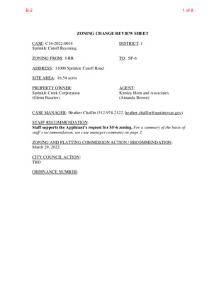
ZONING CHANGE REVIEW SHEET TO: SF-6 DISTRICT: 1 CASE: C14-2022-0014 Sprinkle Cutoff Rezoning ZONING FROM: I-RR ADDRESS: 11000 Sprinkle Cutoff Road SITE AREA: 16.54 acres PROPERTY OWNER: Sprinkle Creek Corporation (Glenn Bauries) CASE MANAGER: Heather Chaffin (512-974-2122, heather.chaffin@austintexas.gov) STAFF RECOMMENDATION: Staff supports the Applicant’s request for SF-6 zoning. For a summary of the basis of staff’s recommendation, see case manager comments on page 2. ZONING AND PLATTING COMMISSION ACTION / RECOMMENDATION: March 29, 2022: CITY COUNCIL ACTION: TBD ORDINANCE NUMBER: AGENT: Kimley Horn and Associates (Amanda Brown) 1 of 8B-2 C14-2022-0014 2 ISSUES: No issues identified at this time. CASE MANAGER COMMENTS: The subject property is located on the east side of Sprinkle Cutoff Road approximately 500 feet north of Samsung Boulevard. The I-RR zoned property is undeveloped and heavily vegetated. Properties to the north, east and south are primarily developed with single family residences and are zoned I-SF-2 and PUD (Pioneer Crossing). Across Sprinkle Cutoff Road to the west is undeveloped property zoned SF-6. Further west is property zoned I-RR that is developed with single family residences. Please see Exhibits A and B—Zoning Map and Aerial Exhibit. Staff supports the rezoning request to SF-6. The property across Sprinkle Cutoff Road to the west was rezoned from I-RR to SF-6 in 2017 and other properties in the area are zoned for and developed with single family residences. Granting SF-6 zoning on this tract reflects an equal treatment as the property across the road. Granting of SF-6 zoning also provides the opportunity for a variety of housing types in the area. This reflects the goals and objectives of City Council as outlined in the Strategic Housing Blueprint. Staff has received correspondence regarding the zoning request. Please see Exhibit C- Correspondence. BASIS FOR RECOMMENDATION 1. The proposed zoning should be consistent with the goals and objectives of the City Council. Granting of the request should result in an equal treatment of similarly situated properties. 2. EXISTING ZONING AND LAND USES: ZONING Site North South East West I-RR I-SF-2, PUD PUD PUD SF-6, I-RR LAND USES Undeveloped Single family residential Single family residential Single family residential Undeveloped, Single family residential TIA/NTA: Deferred to site plan, if triggered WATERSHED: Walnut Creek – Water Supply Suburban NEIGHBORHOOD ORGANIZATIONS: Austin Heritage Tree Foundation Bike Austin Harris Branch Master Association, Inc. North Growth Corridor Alliance SELTEXAS Austin Neighborhoods Council Friends of Austin Neighborhoods Homeless Neighborhood Association Pioneer East Homeowners Association, Inc. Sierra Club, Austin Regional Group 2 of 8B-2 C14-2022-0014 3 AREA CASE HISTORIES: NUMBER C14-2016-0134 11126 Sprinkle Cutoff Rd. EXISTING STREET CHARACTERISTICS: REQUEST COMMISSION I-RR to MF-1 ZAP: 4/4/17 to grant SF-6 CITY COUNCIL 10/5/17: to grant SF-6 OTHER STAFF COMMENTS: Comprehensive Planning Environmental 1. The site is not located over the Edwards Aquifer Recharge Zone. The site is in the Walnut Creek Watershed of the Colorado River Basin, which is classified as a Suburban Watershed by Chapter 25-8 of the City's Land Development Code. 2. Under current watershed regulations, development or redevelopment on this site will be subject to the following impervious cover limits: 3 of 8B-2 C14-2022-0014 4 Development Classification % of Gross Site Area % of Gross Site Area with Transfers 60% 50% Single-Family (minimum lot size 5750 sq. ft.) Other Single-Family or Duplex Multifamily Commercial 60% 70% 90% 55% 60% 80% 3. According to floodplain maps there is no floodplain within or adjacent to the project location. 4. Standard landscaping and tree protection will be required in accordance with LDC 25-2 and 25-8 for all development and/or redevelopment. 5. At this time, site specific information is unavailable regarding vegetation, areas of steep slope, or other environmental features such as bluffs, springs, canyon rimrock, caves, sinkholes, and wetlands. 6. Under current watershed regulations, development or redevelopment requires water quality control with increased capture volume and control of the 2-year storm on site. Site Plan SP1) Site plans will be required for any new development other than single-family or duplex residential. SP2) Any development which occurs in an SF-6 or less restrictive zoning district which is located 540 feet or less from property in an SF-5 or more restrictive zoning district will be subject to compatibility development regulations. SP3) Any new development is subject to Subchapter E. Design Standards and Mixed Use. Additional comments will be made when the site plan is submitted. Compatibility Standards SP4) The site is subject to compatibility standards due to the I-SF-2 lot adjacent to the north property line and the single family uses (zoned PUD) on the south and east property lines. Wildland Urban Interface SP5) This site is located within 150 feet of a wildland area, in the Wildland Urban Interface (WUI). Please see this website for more information about construction in the WUI: http://www.austintexas.gov/department/wildland-urban-interface-code Transportation ASMP Assessment Assessment of required transportation mitigation, including the potential dedication of right of way and easements and participation in roadway and other multi-modal improvements, will occur at the time of site plan application. A traffic impact analysis shall be required at the time of site plan if triggered per LDC 25-6-113. A Neighborhood Traffic Analysis shall be required at the time of site plan, if triggered, when land uses and intensities will be known. if triggered per LDC 25-6-114. FYI - There is a proposed Urban Trail adjacent to this site, along the eastern property boundary. The easement required is a minimum of 20 ft as this allows for a 12 ft trail (minimum trail width per the urban trails plan) and room for maintenance activity. This is the same for Tier I and Tier II trails. 4 of 8B-2 C14-2022-0014 5 Transportation Assessment The adjacent street characteristics table is provided below: Parkland PR1: Parkland dedication will be required for the new residential units proposed by this development, condominiums with SF-6 zoning, at the time of subdivision or site plan, per City Code § 25-1-601. Whether the requirement shall be met with fees in-lieu or dedicated land will be determined using the criteria in City Code Title 25, Article 14, as amended. Should fees in-lieu be required, those fees shall be used toward park investments in the form of land acquisition and/or park amenities within the surrounding area, per the Parkland Dedication Operating Procedures § 14.3.11 and City Code § 25-1-607 (B)(1) & (2). If the applicant wishes to discuss parkland dedication requirements in advance of site plan or subdivision applications, please contact this reviewer: thomas.rowlinson@austintexas.gov. At the applicant’s request, PARD can provide an early determination of whether fees in-lieu of land will be allowed. Water Utility AW1. The landowner intends to serve the site with City of Austin water and wastewater utilities. The landowner, at own expense, will be responsible for providing any water and wastewater utility improvements, offsite main extensions, utility relocations and or abandonments required by the land use. The water and wastewater utility plan must be reviewed and approved by Austin Water for compliance with City criteria and suitability for operation and maintenance. Depending on the development plans submitted, water and or wastewater service extension requests may be required. All water and wastewater construction must be inspected by the City of Austin. The landowner must pay the City inspection fee with the utility construction. The landowner must pay the tap and impact fee once the landowner makes an application for a City of Austin water and wastewater utility tap permit. EXHIBITS: A: Zoning Map B. Aerial Exhibit C. Correspondence 5 of 8B-2 PUD C814-96-0003 C814-96-0003 PUD WORN SOLE DR S S A P A S O G R A M R A W N V ATIO ALAY N A C V M R O C F O U Q SIS KLA M ATH W ALK W E V E H Y W O L R U T A E N U R B SF-6 C14-2016-0134 I-RR I-RR C14-96-0007.01 C14-96-0007 LI-PUD C14-2020-0118 E BRAKER LN C814-96-0003 PUD C814-96-0003 C814-96-0003 S H O RT S P R IN G S D R PUD C814-96-0003.12 PUD L S P E W A D R E D G A RIM G PIL PUD PUD MC DONALD WAY I-SF-2 R D R E V A E B Y L S CHETCO DR ! ! ! ! I-SF-2 ! ! ! ! ! ! ! ! ! ! ! ! ! ! S P ! R I N K L ! ! ! E C U T O F F R D ! ! ! ! ! ! ! ! ! ! ! ! ! ! ! ! ! ! ! ! ! ! ! ! ! ! ! ! ! ! ! ! ! ! ! ! ! ! ! ! ! ! ! ! ! ! ! ! ! ! ! ! ! ! C814-96-0003 C814-96-0003.07 C814-96-0003 PUD R O T H T E R L O S O Y A C V B L A Z E B Y D R S A M S U N G B L V D PUD C814-96-0003 CAIN HARVEST DR PUD PUD L O N G D A Y D R PUD PUD PUD C814-96-0003 PUD C814-96-0003.15 PUD D E F E N D E R T R L PUD C814-96-0003.07 C814-96-0003 C814-96-0003 PUD ZONING ZONING CASE#: C14-2022-0014 C814-96-0003 C814-96-0003 PUD LONG DAY CV SILO VALLEY DR PUD FURROW HILL DR PUD ± SUBJECT TRACT ! ! ! ! ! ! PENDING CASE ZONING BOUNDARY This product is for informational purposes and may not have been prepared for or be suitable for legal, engineering, or surveying purposes. It does not represent an on-the-ground survey and represents only the approximate relative location of property boundaries. 1 " = 400 ' This product has been produced by the Housing and Planning Department for the sole purpose of geographic reference. No warranty is made by the City of Austin regarding specific accuracy or Created: 2/9/2022 6 of 8B-2 Legend Zoning Review Cases- IN REVIEW Street Labels Zoning Text 0.2 0 0.08 0.2 Miles NAD_1983_StatePlane_Texas_Central_FIPS_4203_Feet Date Printed: This product is for informational purposes and may not have been prepared for or be suitable for legal, engineering, or surveying purposes. It does not represent an on-the-ground survey. This product has been produced by the City of Austin for the sole purpose of geographic reference. No warranty is made by the City of Austin regarding specific accuracy or completeness. 1: 4,800 Notes 7 of 8B-2 From: Tam Tran Sent: Wednesday, February 23, 2022 1:45 PM To: Chaffin, Heather <Heather.Chaffin@austintexas.gov> Subject: Case #C14-2022-0014 *** External Email - Exercise Caution *** Good morning Heather, I understand that you are the case manager for the 11000 Sprinkle Cutoff Rd zoning redesignation. I have reviewed the application material from Kimley-Horn and associates. As a resident of the Pioneer West community near the area, I am very concerned about the significant increase in traffic around the area should the rezoning be approved and granted. Sprinkle Cutoff, Samsung Blvd are very small thoroughfares and would not be able to accommodate more cars and trucks without expansion from its current two-lanes. I know that cyclists frequently enjoy riding through Sprinkle Cutoff Rd to Springdale or Cameron Rd to get to Decker Lake and the Walnut Creek cycling trails. Can you please tell me if there are plans to widen or improve these roadways? Or added bike lanes? Please let me know when you receive additional detailed plans. Thank you for your time. Take care, Tam H. Tran CAUTION: This email was received at the City of Austin, from an EXTERNAL source. Please use caution when clicking links or opening attachments. If you believe this to be a malicious and/or phishing email, please forward this email to cybersecurity@austintexas.gov. 8 of 8B-2