B-06 (C14-2021-0193 - 7400 South Congress Avenue; District 2).pdf — original pdf
Backup
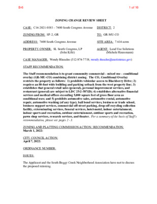
ZONING CHANGE REVIEW SHEET CASE: C14-2021-0193 – 7400 South Congress Avenue DISTRICT: 2 ZONING FROM: SF-2; GR ADDRESS: 7400 South Congress Avenue PROPERTY OWNER: SL South Congress, LP TO: GR-MU-CO SITE AREA: 7.614 acres AGENT: Land Use Solutions (Michele Haussmann) (John Kiltz) CASE MANAGER: Wendy Rhoades (512-974-7719, wendy.rhoades@austintexas.gov) STAFF RECOMMENDATION: The Staff recommendation is to grant community commercial – mixed use – conditional overlay (GR-MU-CO) combining district zoning. The CO, Conditional Overlay restricts the property as follows: 1) prohibits vehicular access to Blackberry Drive; 2) requires an 80-foot wide building and parking setback from the west property line; 3) establishes that general retail sales (general), personal improvement services, and restaurant (general) are subject to LDC 25-2-587(D); 4) establishes alternative financial services and medical offices exceeding 5,000 square feet of gross floor area as conditional uses; and 5) prohibits automotive sales, automotive rental, automotive repair, automotive washing (of any type), bail bond services, business or trade school, business support services, commercial off-street parking, drop-off recycling collection facility, exterminating services, funeral services, hotel-motel, indoor entertainment, indoor sports and recreation, outdoor entertainment, outdoor sports and recreation, pawn shop services, research services, and theater. For a summary of the basis of Staff’s recommendation, please see pages 2 - 3. ZONING AND PLATTING COMMISSION ACTION / RECOMMENDATION: March 1, 2022: CITY COUNCIL ACTION: April 7, 2022: ORDINANCE NUMBER: ISSUES: The Applicant and the South Boggy Creek Neighborhood Association have met to discuss the proposed rezoning. 1 of 16B-6 Page 2 C14-2021-0193 CASE MANAGER COMMENTS: The subject lot is undeveloped and located on the west side of South Congress Avenue, between William Cannon Drive on the north and Dittmar Road on the south. The property is zoned GR, community commercial along the South Congress frontage (to a depth of 385 feet) and SF-2, single family residence – standard lot for the remainder. The lot is adjacent to apartments, a single family residence, a recording studio and a recently constructed attached condominium community to the north (MF-2-CO, SF-6-CO, MF-3, SF-6); a large apartment complex and a single family residence across South Congress to the east (MF-3- CO, SF-2); a natural gas pipeline and easement, and attached condominiums to the south (DR, MF-2-CO, RR); and single family residences in the Meadowcreek subdivision to the west (DR, SF-2, SF-3). Please refer to Exhibits A (Zoning Map) and A-1 (Aerial View). The Applicant proposes to rezone the property to the community commercial – mixed use – conditional overlay (GR-MU-CO) district and construct up to 310 multifamily residential units and a commercial component of limited size. The proposed Conditional Overlay would limit development as follows: 1) restricts commercial uses to those allowed in the neighborhood commercial (LR) district; 2) prohibits vehicular access to Blackberry Drive (therefore access will be taken to South Congress Avenue); and 3) prohibits buildings and parking within 80 feet of the west property line. As it pertains to the proposed dwelling units, a 50-foot building setback is required from the gas lines (as verified by a survey), and additional building construction and design standards are required for the residential units, such as sprinklering, restriction on location of and materials to be used such as rated glass windows, steel clad / solid core doors, and non- combustible material (such as metal) roofs. BASIS OF RECOMMENDATION: 1. The proposed zoning should be consistent with the purpose statement of the district sought. The proposed community commercial (GR) district is intended for office and commercial uses serving neighborhood and community needs, including both unified shopping centers and individually developed commercial sites, and typically requiring locations accessible from major trafficways. The mixed use (MU) district is intended to allow for office, retail, commercial and residential uses to be combined in a single development. The Conditional Overlay (CO) combining district may be applied in combination with any base district. The district is intended to provide flexible and adaptable use or site development regulations by requiring standards tailored to individual properties. The Applicant requests the GR base zoning district which permits buildings up to 60 feet in height, -MU which includes commercial uses and residential uses, and -CO to limit development as it pertains to vehicular access, land uses, and setbacks. 2 of 16B-6 Page 3 C14-2021-0193 2. Zoning should promote clearly identified community goals such as creating employment opportunities or providing for affordable housing. South Congress Avenue is a Level 3 street (arterial) in Austin’s Strategic Mobility Plan (ASMP) adopted in April 2019. There are two travel lanes in each direction with a center turn lane, and sidewalks along both sides of the road. The City Council adopted Core Transit Corridors and Future Core Transit Corridors in 2006, and adopted the Imagine Austin Comprehensive Plan (IACP) on June 15, 2012. The proposed location on South Congress Avenue is an IACP activity corridor and on a designated Future Core Transit Corridor. The proposed location is where compact development should be located in conjunction with retail, service, entertainment, education and employers. Places where people can walk and bike to accomplish some daily tasks. Activity corridors help to increase the level of physical activity promoting health goals and reducing reliance on fossil-fuel based transportation thereby supporting environmental goals. Staff supports the Applicant’s request for GR-MU-CO zoning since the proposed apartments and retail uses would be consistent with existing uses on the corridor. The proposed development is mixed use and would add to the variety of housing choices available in the area. The Conditional Overlay limits the more intensive commercial uses allowed in GR zoning, and creates an additional buffer between the proposed development and the adjacent single family residences. EXISTING ZONING AND LAND USES: ZONING SF-2; GR Site North MF-2-CO; SF-6-CO; MF-3; SF-6 South DR; MF-2-CO; RR East West SF-2; MF-3-CO DR; SF-2; SF-3 LAND USES Undeveloped One single family residence; Apartments; Recording studio; Attached condominiums Pipeline easement; Attached condominiums One single family residence; Apartments Single family residences in the Meadowcreek subdivision NEIGHBORHOOD PLANNING AREA: Not Applicable TIA: Is not required WATERSHED: South Boggy Creek – Suburban CAPITOL VIEW CORRIDOR: No SCHOOLS: An Educational Impact Statement is required. Please refer to Attachment A. Williams Elementary School COMMUNITY REGISTRY LIST: 511 – Austin Neighborhoods Council Bedichek Middle School SCENIC ROADWAY: No Crockett High School 627 – Onion Creek Homeowners Assoc. 3 of 16B-6 Page 4 1363 – SEL Texas 1429 – Go Austin Vamos Austin (GAVA) – 78745 C14-2021-0193 742 – Austin Independent School District 1228 – Sierra Group, Austin Regional Group 1306 – Parkridge Gardens HOA 1424 – Preservation Austin 1440 – South Boggy Creek Environmental Association 1494 – South Boggy Creek Neighborhood Association 1530 – Friends of Austin Neighborhoods 1531 – South Austin Neighborhood Alliance (SANA) 1550 – Homeless Neighborhood Association 1616 – Neighborhood Empowerment Foundation 1774 – Austin Lost and Found Pets 1787 – Circle S. Ridge Neighborhood Association AREA CASE HISTORIES: REQUEST COMMISSION CITY COUNCIL DR to MF-3 To Grant Apvd (9-19-2019). DR to SF-6 To Grant Apvd (5-4-2017). LO to LO-MU To Grant Apvd (2-27-2014). DR to LO To Grant Apvd LO (2-28-2002). NUMBER C14-2019-0085 – 7308 S Congress Avenue C14-2017-0007 – 7300 S Congress Ave Rezoning C14-2013-0157 – Rezoning of 7200, 7202 and 7204 South Congress C14-01-0179 – Bethania Rezoning – 7110 S Congress Ave C14-99-2065 – John Lewis Tract – 7201- 7401 S Congress Ave SF-3 to MF-3 To Grant MF-2-CO w/CO for 2,000 trips/day C14-96-0057 – Goel Zoning Change – 7310 S Congress Ave DR to MF-2 To Grant MF-2 for Tract 1 & SF-6 for Tract 2, with conditions Apvd MF-3-CO w/CO for 23 u.p.a., 2,000 trips and prohibit vehicular access to Circle S Rd (8-17-2000). Apvd MF-2-CO for Tract 1 and SF-6-CO for Tract 2, w/CO which requires access to S Congress Ave; 25’ undisturbed buffer on west property line; limit Tract 2 to two single family dwelling units; and multifamily development limited to 18 units per acre on Tract 1 (9-26-1996). 4 of 16B-6 Page 5 C14-2021-0193 RELATED CASES: The property was annexed into the City limits on November 15, 1984 (C7A-83-017 A). In April 1985, Council approved GR zoning for the 2.58 acre South Congress frontage (C14-84- 456 – Joyce & Issam Kussad). In May 1996, Council approved SF-2 zoning for the remaining 5.133 acres of the property (C14-94-0098 – Pecan Grove on the Avenue). The rezoning area is platted as Lot 1, Block A of South Congress District Final Plat – A Resubdivision of the Ennis Subdivision, recorded in October 2021 (C8-2021-0074.0A). EXISTING STREET CHARACTERISTICS: Name Pavement Classification Sidewalks ROW South Congress Avenue Broken Arrow Lane Blackberry Lane 108 feet 70 feet 46 feet 30 feet 45 to 50 feet 28 feet Level 3 (Minor Arterial) Level 1 (Local) Level 1 (Local) Yes No Yes Bicycle Route Bike Lane - Buffered Capital Metro (within ¼ mile) Yes No No No No The City of Austin’s 2016 Mobility Bond provided funding for development of a Corridor Mobility Plan for South Congress Avenue, south shore of Lady Bird Lake to Slaughter Lane. The plan would make recommendations to improve safety, mobility, and connectivity for all corridor users, including people who drive, walk, bike, and take transit. Below is a link to the Corridor page: South Congress Avenue Corridor | Open Data | City of Austin Texas OTHER STAFF COMMENTS: Comprehensive Planning This rezoning case is located on the west side of South Congress Avenue on a vacant property that is approximately 7.614 acres in size and is not located within the boundaries of a neighborhood planning area. The property is located along the South Congress Activity Corridor. Surrounding land uses include multifamily and single family uses to the north; to the south is a townhouse development; to the east is a multifamily complex; and to the west are single family houses. According to the agent, the proposal is to obtain mixed use zoning to construct a 310-unit multi-family apartment complex, and potentially the inclusion of a coffee shop or restaurant for a commercial use. 5 of 16B-6 Page 6 C14-2021-0193 Connectivity Imagine Austin There is almost a complete public sidewalk system located along both sides of South Congress Avenue (between William Cannon Boulevard and Slaughter Lane). There is a CapMetro transit stop within 200 ft. of the property. Bike lanes are also located along both sides of South Congress Avenue. The mobility and connectivity options in the area are good. There are a variety of commercial and retail uses located to the south, less than a mile from the subject property, which is accessible by public transit and by foot. The Imagine Austin Growth Concept Map identifies this project as being located along an Activity Corridor, which is intended for a variety of activities and types of buildings for shopping, restaurants and cafés, parks, schools, single-family houses, apartments, public buildings, houses of worship, mixed-use buildings, and offices. The following Imagine Austin policies are applicable to this project: • LUT P1. Align land use and transportation planning and decision-making to achieve a compact and connected city in line with the growth concept map. • LUT P4. Protect neighborhood character by directing growth to areas of change that includes designated redevelopment areas, corridors and infill sites. Recognize that different neighborhoods have different characteristics and new and infill development should be sensitive to the predominant character of these communities. • HN P10. Create complete neighborhoods across Austin that have a mix of housing types and land uses, affordable housing and transportation options, and access to schools, retail, employment, community services, and parks and recreation options. Based on this property: (1) being situated along an Activity Corridor, which supports mixed use and multifamily uses; (2) other residential uses located within a quarter mile radius of this site, including single family houses, townhouses, and multifamily apartment complexes; and (3) the existing mobility and connectivity options available in the area (public sidewalks, bike lanes, a transit stops and nearby commercial and retail uses); this proposed multifamily / mixed use project supports the policies of the Imagine Austin Comprehensive Plan. Drainage The developer is required to submit a pre- and post-development drainage analysis at the subdivision and site plan stage of the development process. The City’s Land Development Code and Drainage Criteria Manual require that the Applicant demonstrate through engineering analysis that the proposed development will have no identifiable adverse impact on surrounding properties. Environmental The site is not located over the Edwards Aquifer Recharge Zone. The site is in the south Boggy Creek Watershed of the Colorado River Basin, which is classified as a Suburban 6 of 16B-6 C14-2021-0193 Watershed by Chapter 25-8 of the City's Land Development Code. The site is in the Desired Development Zone. Under current watershed regulations, development or redevelopment on this site will be subject to the following impervious cover limits: Page 7 Development Classification % of Gross Site Area % of Gross Site Area Single-Family (minimum lot size 5750 sq. ft.) Other Single-Family or Duplex Multifamily Commercial 50% 55% 60% 80% with Transfers 60% 60% 70% 90% According to floodplain maps there is a floodplain adjacent to the project location. Based upon the location of the floodplain, offsite drainage should be calculated to determine whether a Critical Water Quality Zone exists within the project location. Standard landscaping and tree protection will be required in accordance with LDC 25-2 and 25-8 for all development and/or redevelopment. At this time, site specific information is unavailable regarding vegetation, areas of steep slope, or other environmental features such as bluffs, springs, canyon rimrock, caves, sinkholes, and wetlands. Under current watershed regulations, development or redevelopment requires water quality control with increased capture volume and control of the 2-year storm on site. Austin Fire Department Austin Fire Department (AFD) staff has reviewed the proposed rezoning case for any potential issues with hazardous materials sites in the area and found none. AFD does not oppose a multifamily development or change to residential zoning for this site. Impervious Cover Within the South Boggy Creek watershed, the maximum impervious cover allowed by the GR-MU-CO zoning district is 80% (90% with transfers), which is based on the more restrictive watershed regulations. PARD – Planning & Design Review Parkland dedication will be required at the time of subdivision or site plan application for new residential units, per City Code § 25-1-601, as amended. The proposed development meets the criteria for land dedication in City Code Title 25, Article 14. As such, a partial land 7 of 16B-6 Page 8 C14-2021-0193 dedication would be required, as well as any remaining fees in-lieu. The requirement would help improve connectivity to the Meadow Lea Pocket Parks to the north of the site. The development as proposed will require parkland dedication for the new residential units that will serve this neighborhood through the additional park investment. The Parks and Recreation Department (PARD) would consider a connection from South Congress Avenue, to Blackberry Drive and the adjacent Meadow Lea/7300 South Congress project, toward satisfying the requirement at time of permitting (whether subdivision or site plan). Such a connection would improve neighborhood connectivity to parkland, a recommendation identified in the Parks and Recreation Department’s Long Range Plan. Should there be any remaining fees in-lieu, those fees shall be used toward park investments in the form of land acquisition and/or park amenities within the surrounding area, per the Parkland Dedication Operating Procedures § 14.3.11 and City Code § 25-1-607 (B)(1) & (2). Should the applicant wish to discuss parkland dedication requirements in advance of site plan or subdivision applications, please contact this reviewer: thomas.rowlinson@austintexas.gov. At the applicant’s request, PARD can provide an early determination letter of the requirements as stated in this review. Site Plan and Compatibility Standards Site plans will be required for any new development other than single-family or duplex residential. Any development which occurs in an SF-6 or less restrictive zoning district which is located 540 feet or less from property in an SF-5 or more restrictive zoning district will be subject to compatibility development regulations. Any new development is subject to Subchapter E: Design Standards and Mixed Use. Additional comments will be made when the site plan is submitted. FYI: Additional design regulations will be enforced at the time a site plan is submitted. The site is subject to compatibility standards due to adjacency of DR and SF-2 zoned lots to the west. The following standards apply: • No structure may be built within 25 feet of the property line. • No structure in excess of two stories or 30 feet in height may be constructed within 50 • No structure in excess of three stories or 40 feet in height may be constructed within feet of the property line. 100 feet of the property line. • For a structure more than 100 feet but not more than 300 feet from property zoned SF-5 or more restrictive, height limitation is 40 feet plus one foot for each 10 feet of distance in excess of 100 feet from the property zoned SF-5 or more restrictive. 8 of 16B-6 C14-2021-0193 Page 9 • For a structure more than 300 feet but not more than 540 feet from property zoned SF-5 or more restrictive, 60 feet plus one foot for each four feet of distance in excess of 300 feet from the property zoned SF-5 or more restrictive. • No parking or driveways are allowed within 25 feet of the property line. • Landscaping or screening is required along the west property line in accordance with the screening requirements (Section 25-2-1006 and ECM 2.9.1.), Parking Design Standards (Section 25-6-563) and/or Screening Standards (Section 25.2.1066) to screen adjoining properties from views of parking, mechanical equipment, storage, and refuse collection. • An intensive recreational use, including a swimming pool, tennis court, ball court, or playground, may not be constructed 50 feet or less from property in an SF-5 or more restrictive zoning district. • A landscape area at least 25 feet in width is required along the property line if the tract is zoned LR, GO, GR, L, CS, CS-1, or CH. ATD Engineering Review ASMP Assessment The Austin Strategic Mobility Plan (ASMP) calls for 140 feet of right-of-way for S Congress Avenue and 50 feet of right-of-way for Broken Arrow Lane and Blackberry Lane. It is recommended that 70 feet of right-of-way from the existing centerline should be dedicated for S Congress Avenue, and 25 feet of right-of-way from the existing centerlines should be dedicated for Broken Arrow Lane and Blackberry Lane according to the Transportation Plan with the first subdivision or site plan application [LDC 25-6-51 and 25-6-55]. Transportation Assessment Assessment of required transportation mitigation, including the potential dedication of right of way and easements and participation in roadway and other multi-modal improvements, will occur at the time of site plan application. A traffic impact analysis shall be required at the time of site plan if triggered per LDC 25-6-113. Austin Water Utility The landowner intends to serve the site with City of Austin water and wastewater utilities. The landowner, at own expense, will be responsible for providing any water and wastewater utility improvements, offsite main extensions, utility relocations and or abandonments required by the land use. The water and wastewater utility plan must be reviewed and approved by Austin Water for compliance with City criteria and suitability for operation and maintenance. Depending on the development plans submitted, water and or wastewater service extension requests may be required. All water and wastewater construction must be inspected by the City of Austin. 9 of 16B-6 Page 10 C14-2021-0193 The landowner must pay the City inspection fee with the utility construction. The landowner must pay the tap and impact fee once the landowner makes an application for a City of Austin water and wastewater utility tap permit. INDEX OF EXHIBITS, ATTACHMENT, AND CORRESPONDENCE TO FOLLOW: A: Zoning Map A-1: Aerial Map Attachment A – Educational Impact Statement Correspondence Received 10 of 16B-6 SF-2 SF-6 C14-2017-0007 ( ( ( ( ( ( SF-3 ( ( ( ( ( ( ( ( ( ( ( ( ( ( ( ( ( ( ( ( ( ( ( ( R D D O O W Y D A H S ( ( ( ( ( ( ( ( ( ( ( ( ( ( ( ( ( ( ( SF-3 SF-3 ( ( ( ( ( ( ( ( ( ( ( ( ( ( ( ( ( ( ( SF-6 SF-3 ( ( ( ( ( ( SF-2 ( ( Y CIR ( ( ( ( ( ( ( SF-2 ( ( SF-3 N W TA ( SF-2 ( ( TA W N ( ( Y D R ( ( ( ( M EAD O ( W LEA D R ( ( ( ( SF-3 ( ( ( ( ( ( ( R R D A N U L ( ( ( ( ( ( ( ( ( ( ( ( ( ( ( ( R LY D ( ( R E B KIM ( ( ( ( 81-131 SF-2 ( ( ( ( ( ( ( SF-2 ( ( ( ( ( ( ( ( ( SF-2 ( ( ( ( ( ( ( ( ( ( ( ( ( ( ( ( ( ( ( ( ( ( ( ( R D Y R R E B N A G O L ( ( ( ( ( ( ( ( ( ( ( ( N L W O R R A N E K O R B ( ( ( ( DR ( ( ( ( ! ! ! ! ! ! ! ! ! ( ( ( ( ( ( ( SF-3 ( ( ( ( ( ( ( ( ( ( ( LOGANBERRY CT ( ( ( ( ( ( ( SF-2 ( ( ( ( ( ( ( ( ( ( ( ( ( ( ( SF-2 ( ( ( ( ! ! ! ! ! ! ! ! ! ! ! ! ! ! ! ! ! ! ! BLACKBERRY DR ( ( ( ( ( ( ( ( ( SF-3 ( ( SF-3 ( ( ( ( ( ( ( ( ( ( W D I T T M A R R D ( ! ! ! ( DR ( ! HILL LN ! ! SF-3 C14-99-0032 = ! ! ( ( ( ( ( ( SF-2 ( ( BYR D ! ! ! ! NO-CO ( ( ( ( ( ( ( C A PE ! ! ! ( ( SF-2 ( ( ( ( ( ( ( ( ( ! ! ! ! ± 02-0169 C14-02-0169 ! ! ! ! ! ! ( ! ! ! ! ! ! EFUL HILL LN ! ! ! C14-02-0168 02-0168 ! ! ! ! ! ! ! ! ! ! ! ! ! ! SUBJECT TRACT ! ! ! ! ! ! ! ! ! ! ! ! PENDING CASE ! ! ! ! ! ! ZONING BOUNDARY ! ! ! ! ! ! ! ! ( ( ( ( ( ( SF-3 ( ( ( ( ( ( ( ( ( ( ( ( R RIC D LY ( ( SF-2 ( ( ( ( ( ( ( ( ( ( ( ( ( ( ( ( C L O ( ( U D VIE ( ( ( ( SF-3 W D R ( ( SF-3 ( ( ( ( ( ( = ( ( = = METEO SF-3 = R D R MF-2 = ( ( = = ( ( = ( = = CHUR CH LO C14-01-0179 01-0179 DR ( ( SF-2 ( ( ( R L D L E ( G W HIN WIS ( ( ( DR ( R D D R A G G A H THELONIOUS DR MINI W A REH O US ES O LG UIN S T (N O T O N G R O U N D) M H C14-2013-0157 ( LO-MU ( DR R G D DIN D E R UNDEV R Y D A W N O C S T N E M T R A P A LO APARTMENTS P82-63 APTS ( ( SF-3 C14-2015-0123 ( ( ( ( SF-3 ( ( = = = = = ( ( ( SF-2 ( = CHAPARRAL RD ( ( ( ( ( SF-2 = = = SF-3 = = = 79-243 = = ( ( ( ( ( C14-2016-0033 SF-3 ( C O R R AL LN 2 3 84-2 ( MF-3 C14-2019-0085 96-0057 ( MF-3-CO SF-2 CEMETERY E V A S S E R G N O C S ! ! SF-6-CO ( 96-0057 ! ! ! ! 94-0098 SF-2 UNDEV ! MF-2-CO ! C14-96-0057 ! ! ! ! ! ! ! ! ! ! DR ! ! ! ! ! ! MERRICK LN MF-2-CO BRIDGEFORD DR UNDEV 94-0097 APARTMENTS ! ! ! ! UNDEV GR ! ! 84-456 ! ! ! ! ! ! ! ! ! ! ! PIPELINE EASEMENT ! ! ! ! SP-01-0207C ( 99-2065 D R S E L C IR C C2-66-001D CLASS RING CO. LI B E L F A I R T E R ! ! ! ! ! ! ! ! ! ! ! ! ( SF-2 V E D N U 98 -0 0 33 84-262 E DITTMAR RD UNDEV CS 84-124 GR SF-3 UNDEV C2-66-001D ONION CREEK LODGE CEMETERY SF-2 MF-4-CO 12-31-75 DR ! ! ! ! ! ! ! ! ! ! ! ! ! ! ! ! ZONING Exhibit A ZONING CASE#: C14-2021-0193 ! RR 94-0097 ! ! ! ! ! ! ! ! ! ! ! ! ! ! ! ! ! ! ! ! ! ! ! ! 1 " = 400 ' ! ! ! This product is for informational purposes and may not have been prepared for or be suitable for legal, engineering, or surveying purposes. It does not represent an on-the-ground survey and represents only the approximate relative location of property boundaries. ! ! ! ! ! ! ! ! ! ! ! ! ! ! ! ! ! ! ! This product has been produced by the Housing and Planning Department for the sole purpose of geographic reference. No warranty is made by the City of Austin regarding specific accuracy or ! ! ! ! Created: 12/28/2021 11 of 16B-6 Exhibit A - 1 688101312TRACTA32211312172343231243920411910915242030191622542142346815113285765163416128742342014343019202115119231422831617113642341101411176121221218224699131129281086712222181615321011457232223201619291824192615211014242282634112181734141518192338512622449211520191816141530898B237551315131131828272171121315282616125188532578131427877211176142047120171922156275515A491012233138171110203012191211816275204340316443231934201811714817861027732A6B112314193271439213561532492A222922156193335932362023123098191813215412117256243163711353113129A14161710914186791023130277182927373813142327316154217401554152127317131431124A16106432121241411201136353322171819325121514122412325298191351085715161326225536321418C14-2021-0193SF-6SF-3SF-2SF-6-CODRSF-2SF-2DRSF-2SF-2SF-3SF-2SF-3MF-3LO-MUSF-3DRSF-3SF-2SF-2SF-3SF-2SF-3DRSF-2NO-COSF-3SF-3SF-2DRDRSF-3DRSF-3GRLOSF-2SF-3SF-3SF-6CSMF-3-COLIMF-2SF-3SF-3SF-2MF-4-COSF-3SF-2RRMF-2-COSF-2SF-2SF-2MF-2-COGRLOSF-2REDDINGDRBELFAIRTERRAYCHARLES DRPLANTSTTAWNYCIRTHELONIOUS DRCHAPARRALRDTAWNYDRW DITTMAR RDBYRDHILLLNBLACKBERRYDRLOGANBERRY CTMEADOWLEADRBRIDGEFORDDRLYRICDRCORRALLNMETEOR DRMEADOWLEA DRE DITTMAR RDPEACEFUL HILL LNWISHINGWELLDRS CONGRESSAVEKIMBERLYDRCIRCLES RDOLGUIN STBROKEN ARROW LNCLOUDVIEWDRS CONGRESSAVELOGANBERRY DRW DITTMAR RDCIRCLES RDLUNAR DRCIRCLES RDSHADYWOOD DRG15Copyright nearmap 2015This map has been produced by the Communications Technology Management Dept. on behalf of thePlanning Development Review Dept. for the sole purpose of geographic reference. No warranty is madeby the City of Austin regarding specific accuracy or completeness.ZONING CASE#:LOCATION:SUBJECT AREA:GRID:MANAGER:C14-2021-01937400 South Congress Avenue7.614 ACRESG15WENDY RHOADES1'' = 400'ZONING BOUNDARYCREEK BUFFERPENDING CASE!!!!!!SUBJECT TRACT7400 South Congress Avenue12 of 16B-6 EDUCATIONAL IMPACT STATEMENT Prepared for the City of Austin Austin Independent School District PROJECT NAME: 7400 S. Congress Avenue ADDRESS/LOCATION: 7400 S. Congress Avenue CASE #: C14-2021-0193 NEW SINGLE FAMILY NEW MULTIFAMILY DEMOLITION OF MULTIFAMILY TAX CREDIT # SF UNITS: STUDENTS PER UNIT ASSUMPTION Elementary School: Middle School: High School: # MF UNITS: 270 STUDENTS PER UNIT ASSUMPTION Elementary School: 0.074 Middle School: 0.030 High School: 0.044 IMPACT ON SCHOOLS The student yield factor of 0.148 (across all grade levels) for apartment homes was used to determine the number of projected students. This was determined by the district’s demographer by looking at similar projects in the area. The proposed 270-unit multifamily development is projected to add approximately 40 students across all grade levels to the projected student population. It is estimated that of the 40 students, 20 will be assigned to Williams Elementary School, 8 to Bedichek Middle School, and 12 to Crockett Early College High School. The percent of permanent capacity by enrollment for School Year 2025-26, including the additional students projected with this development, would be within the optimal utilization target range of 85-110% at Williams ES (90%), below the target range at Bedichek MS (61%), and Crockett ECHS (75%). TRANSPORTATION IMPACT Students attending Williams ES and Bedichek MS will not qualify for transportation unless a hazardous route condition is identified. Students at Crockett ECHS will qualify for transportation with no impact. SAFETY IMPACT There are not any identified safety impacts at this time. Date Prepared: 02/15/2022 Executive Director: [1] Attachment A 13 of 16B-6 EDUCATIONAL IMPACT STATEMENT Prepared for the City of Austin Austin Independent School District DATA ANALYSIS WORKSHEET ELEMENTARY SCHOOL: Williams ADDRESS: 500 Mairo St. POPULATION (without mobility rate) ELEMENTARY SCHOOL STUDENTS 2020-21 Population Number 433 77% % of Permanent Capacity ENROLLMENT (with mobility rate) ELEMENTARY SCHOOL STUDENTS 2020-21 Enrollment Number % of Permanent Capacity 415 74% MIDDLE SCHOOL: Bedichek ADDRESS: 6800 Bill Hughes Road POPULATION (without mobility rate) MIDDLE SCHOOL STUDENTS 2020-21 Population Number 886 94% % of Permanent Capacity ENROLLMENT (with mobility rate) MIDDLE SCHOOL STUDENTS 2020-21 Enrollment Number % of Permanent Capacity 781 83% PERMANENT CAPACITY: -4.2% MOBILITY RATE: 561 5- Year Projected Population (without proposed development) 5-Year Projected Population (with proposed development) 5- Year Projected Enrollment (without proposed development) 5-Year Projected Enrollment (with proposed development) PERMANENT CAPACITY: MOBILITY RATE: -11.9% 941 5- Year Projected Population (without proposed development) 5-Year Projected Population (with proposed development) 5- Year Projected Enrollment (without proposed development) 5-Year Projected Enrollment (with proposed development) 519 93% 506 90% 689 73% 577 61% 499 89% 486 87% 681 72% 569 60% [2] 14 of 16B-6 EDUCATIONAL IMPACT STATEMENT Prepared for the City of Austin Austin Independent School District Crockett HIGH SCHOOL: ADDRESS: 5601 Menchaca Road POPULATION (without mobility rate) HIGH SCHOOL STUDENTS 2020-21 Population Number 1,440 67% % of Permanent Capacity ENROLLMENT (with mobility rate) HIGH SCHOOL STUDENTS 2020-21 Enrollment Number % of Permanent Capacity 1,555 72% PERMANENT CAPACITY: MOBILITY RATE: +8.0% 2,163 5- Year Projected Population (without proposed development) 5-Year Projected Population (with proposed development) 5- Year Projected Enrollment (without proposed development) 5-Year Projected Enrollment (with proposed development) 1,269 59% 1,624 75% 1,257 58% 1,612 75% [3] 15 of 16B-6 From: To: Subject: Date: Rhoades, Wendy Question about Case Number - C14-2021-0193 Saturday, February 12, 2022 2:18:12 PM *** External Email - Exercise Caution *** Hi Wendy, My name is Neal Cook. Nice to meet you. I received a letter about a proposed zoning change to a large plot of land close to me. I currently live at 7403 Brickyard Ct, Austin, TX 78745. The Case Number is C14-2021-0193. I want to share my concerns over the proposed zoning change to MU - Mixed Use combining district. The current zoning of GR and SF-2 is much more aligned with what I'd like to see in the surrounding property of South Congress. There's too much multi-family, condensed living going up in the area, and there needs to be a balance of single-family as well as office/commercial. Anywho, that's just my opinion, but I wanted to share that with you. I know there will be a public hearing at some point in the future, so I will be on the lookout for that date/time. Thank you for your time, and I hope you enjoy your weekend! Neal -- 267-528-5247 CAUTION: This email was received at the City of Austin, from an EXTERNAL source. Please use caution when clicking links or opening attachments. If you believe this to be a malicious and/or phishing email, please forward this email to cybersecurity@austintexas.gov. 16 of 16B-6