B-12 (C8-2020-0188.0A - 1940 Webberville Road Subdivision; District 1).pdf — original pdf
Backup
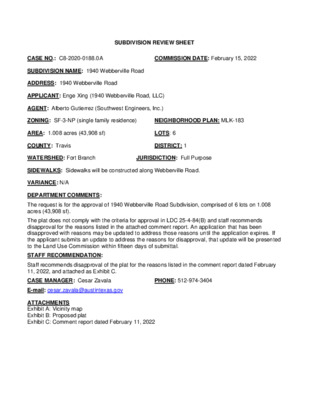
SUBDIVISION REVIEW SHEET CASE NO.: C8-2020-0188.0A COMMISSION DATE: February 15, 2022 SUBDIVISION NAME: 1940 Webberville Road ADDRESS: 1940 Webberville Road APPLICANT: Enge Xing (1940 Webberville Road, LLC) AGENT: Alberto Gutierrez (Southwest Engineers, Inc.) ZONING: SF-3-NP (single family residence) NEIGHBORHOOD PLAN: MLK-183 AREA: 1.008 acres (43,908 sf) LOTS: 6 COUNTY: Travis DISTRICT: 1 WATERSHED: Fort Branch JURISDICTION: Full Purpose SIDEWALKS: Sidewalks will be constructed along Webberville Road. VARIANCE: N/A DEPARTMENT COMMENTS: The request is for the approval of 1940 Webberville Road Subdivision, comprised of 6 lots on 1.008 acres (43,908 sf). The plat does not comply with the criteria for approval in LDC 25-4-84(B) and staff recommends disapproval for the reasons listed in the attached comment report. An application that has been disapproved with reasons may be updated to address those reasons until the application expires. If the applicant submits an update to address the reasons for disapproval, that update will be presented to the Land Use Commission within fifteen days of submittal. STAFF RECOMMENDATION: Staff recommends disapproval of the plat for the reasons listed in the comment report dated February 11, 2022, and attached as Exhibit C. CASE MANAGER: Cesar Zavala PHONE: 512-974-3404 E-mail: cesar.zavala@austintexas.gov ATTACHMENTS Exhibit A: Vicinity map Exhibit B: Proposed plat Exhibit C: Comment report dated February 11, 2022 E M A R T I N L U T H E R K I N G J R B L V D W E B B E R V I L L E R D PROJECT LOCATION Civil Environmental Planning TBPE No.: 1909 www.swengineers.com 205 Cimarron Park Lp. Suite B Buda, Texas 78610 (512) 312-4336 1940 WEBBERVILLE ROAD SUBDIVISION 1940 WEBBERVILLE ROAD AUSTIN, TX 78721 1940 WEBBERVILLE RD, LLC Date: File: Scale: Tech: Project No.: 05/06/2020 Exhibit N.T.S. LS 0690-004-19 LOCATION MAP CITY OF AUSTIN –DEVELOPMENT SERVICES DEPARTMENT SUBDIVISION APPLICATION – MASTER COMMENT REPORT U0 512-974-3404 1940 Webberville Road Subdivision 1940 WEBBERVILLE RD C8-2020-0188.0A 00 UPDATE: Cesar Zavala PHONE #: CASE NUMBER: REVISION #: CASE MANAGER: PROJECT NAME: LOCATION: SUBMITTAL DATE: January 17, 2022 REPORT DUE DATE: February 11, 2022 FINAL REPORT DATE: February 11, 2022 STAFF REPORT: 1 DAY HAS BEEN ADDED TO THE UPDATE DEADLINE This report includes all staff comments received to date concerning your most recent subdivision application submittal. The comments may include requirements, recommendations, or information. The requirements in this report must be addressed by an updated submittal. The subdivision application will be approved when all requirements from each review discipline have been addressed. If you have any questions, concerns or if you require additional information about this report, please contact your case manager at the phone number listed above or by using the contact information listed for each reviewer in this report. Any change to the plan/plat shall not cause noncompliance with any applicable code or criteria. In addition, any change to the plat may trigger new comments. UPDATE DEADLINE INFORMATION (LDC 25-4-56; 25-4-82): All comments must be addressed by filing an updated submittal prior to the update deadline of April 18, 2022 . Otherwise, the application will expire. If this date falls on a weekend or City of Austin holiday, the next City of Austin workday will be the deadline. Extension of Review Period, Extension of Update Deadline and Tolling of Application Period do not apply to applications for preliminary plan, plat or subdivision construction plans (LDC 25-1-88; 25-1-89; 25-1- 90). UPDATE SUBMITTAL INSTRUCTIONS (LDC 25-1-83): 1. Applicants must make an appointment with Intake Staff (512-974-1770 or LURIntake@austintexas.gov ) in order to submit an update. 2. Your update must include the following items: a. This report b. The revised plat/plan in pdf format c. A letter that addresses each comment in the master comment report 3. Updates must be submitted on an approved submittal date, between the hours of 8:30 am and 4:00 pm. Refer to the submittal calendar for a list of approved submittal dates. IMPORTANT NOTICE: the City of Austin Mayor and Travis County Judge COVID orders that suspended deadlines are set to end on March 1, 2022. Unless this deadline is extended, applications or determinations will begin expiring again on or after March 2, 2022. Please review the coversheet of the most recent staff report to find the expiration date. FYI: Preliminary Plan and Final Plat applications expire after 90 days and Subdivision Construction Plans expire after 1 year unless the application has been approved. REVIEWERS: Planner 1 : Cindy Edmond AW Utility Development Services : Derek Tucker Drainage Engineering : Kyle Virr Subdivision : Nicholas Coussoulis Plumbing for Site Plan: Cory Harmon Electric : Cody Shook ATD Engineering : Lee Miller PARD / Planning & Design : Scott Grantham Water Quality : Kyle Virr ATD 1. ATD 2. Electric Review - Cody Shook - Cody.Shook@austinenergy.com EL 1. LDC § 25-4-132 - EASEMENTS AND ALLEYS. (A) Easements for public utilities and drainage ways shall be retained in all subdivisions in the widths and locations determined necessary by the director. All easements shall be dedicated to public use for the named purpose and shall be aligned to minimize construction and future maintenance costs. Source: § 13-2-421; Ord. 990225-70; Ord. 010607-8; Ord. 031211-11; Ord. 20131017-046 Fifteen foot electric distribution, electric telecommunications, and electric fiber easement is required adjacent to street R.O.W. along Webberville Rd and along western lot line of this site to protect existing overhead electric facilities. Show the easement(s) on the face of the plat. EL 2. LDC § 25-4-132 - EASEMENTS AND ALLEYS. (A) Easements for public utilities and drainage ways shall be retained in all subdivisions in the widths and locations determined necessary by the director. All easements shall be dedicated to public use for the named purpose and shall be aligned to minimize construction and future maintenance costs. Source: § 13-2-421; Ord. 990225-70; Ord. 010607-8; Ord. 031211-11; Ord. 20131017-046 Ten foot electric distribution, electric telecommunications, and electric fiber easement is required along the eastern lot line of this site. Show the easement(s) on the face of the plat. 911 Addressing Review - Jorge Perdomo - 512-974-1620 AD1: This plat review is cleared; however, any changes to street names, street name labels, or street layouts will require a new review. §25-4-155 ATD Engineering Review - Lee Miller - 512-974-6472 A joint-use driveway used as alternative access for a single-family residential use may serve not more than eight dwelling units. LDC 25-6-451(C). Provide a plat not restricting the number of dwelling units accessing the single joint use access easement driveway. If more than 3 residences are served by a single joint use driveway, the following requirements shall apply: -The developer must post fiscal surety for the construction of the driveway prior to plat approval and must construct the driveway during construction of the streets within the subdivision, or within the term of the fiscal instrument if no streets are constructed within the subdivision. -The developer must construct a driveway, designed by a professional engineer, to have an all-weather surface and a pavement structure meeting at least private street standards. The driveway must be designed to have no more than 9 inches of water overtopping the driveway during the 100-year storm event. -The developer must construct a turnaround meeting City of Austin Fire Criteria at the end of the driveway, or no further than 200 feet from the end of the driveway, and must obtain a written signature from the area fire service providers acknowledging their approval of the joint use driveway. -The joint access easement must be dedicated as a public utility easement and may be required to be dedicated as a drainage easement. The access agreement must include a clause indicating that the driveway may be use by public service personnel and equipment for servicing public utilities. -If the developer does not use a restrictive covenant to require homeowners to park all vehicles off the joint use driveway surface, then the joint use driveway surface must be at least 24 feet wide. Otherwise, the driveway surface may be no less than 20 feet wide. -The developer must erect signs indicating "private driveway" at the driveway entrance. LDC30-3-161; TCM, 5.3.1.H Show a survey tie across all existing streets bordering or traversing this subdivision and show the entire right-of-way for Webberville Rd. to verify right-of-way width. LDC 25-4-131. ATD 3. ATD 4. Please remove “for street purposes” from the label in the hatched dedication area. Drainage Engineering Review - Kyle Virr - 512-974-2538 Release of this application does not constitute a verification of all data, information, and calculations supplied by the applicant. The engineer of record is solely responsible for the completeness, accuracy, and adequacy of his/her submittal, whether or not the application is reviewed for code compliance by city engineers. DE1: DCM 1.2.2(D) states, “Stormwater runoff peak flow rates shall not be increased at any point of discharge from a site for the two (2), ten (10), twenty-five (25) and one hundred (100) year storm frequency events”. Please provide the information necessary to verify compliance. DE2: Engineer's seal, signature and date required [LDC 25-7-62]. DE3: Add the following Floodplain Note [LDC 25-7-152]: "The 100 year floodplain is contained within the drainage easement(s) shown hereon. (No or A) portion of this tract is within the boundaries of the 100 year flood plain of any waterway that is within the limits of study of the Federal Flood Insurance Administration FIRM panel # _________________, dated ___________ for _____________________(name of city of county)." This must be certified by registered professional engineer. DE4: DCM 2.4.2 states that “sound engineering judgement should be used to determine a flow path representative of the drainage area.” Please justify the proposed condition flow path and how it is “representative” of the proposed drainage condition. DE5: Please provide plans and details for the proposed detention pond to demonstrate plans comply with all requirements on ECM 1.2.4 (E). DE6: Please add the peak flows leaving the detention pond for each of the storm events to the summary table to demonstrate compliance with DCM 1.2.2(D) which states, “Stormwater runoff peak flow rates shall not be increased at any point of discharge from a site for the two (2), ten (10), 25 and 100-year storm frequency events.” DE7: DCM 1.2.3 (C) states, “If a development is located within 550 feet of an existing storm drain system, the developer shall provide all the necessary infrastructure designed in accordance Update 0: with the criteria in this manual to connect appropriately to the storm drain system.” Please provide information to verify compliance. DE8: If the applicant desires to participate in the Regional Stormwater Management Program (RSMP), please request participation at RSMP@austintexas.gov and copy this reviewer. A feasibility meeting will be set; please include this reviewer. PARD / Planning & Design Review - Scott Grantham - 512-974-9457 PR1. The parkland dedication and park development fee is required (City Code §25-1-601) and must be paid prior to approval. Due to SF-3 zoning, the fee for 10 units must be paid because each lot is large enough for a two-family residential use. Invoices will be issued with the next update. PR2. Add the following note to the plat: A fee-in-lieu of parkland dedication and park development has been paid for 10 units due to SF- 3 zoning. Subdivision Review - Nicholas Coussoulis - nicholas.coussoulis@austintexas.gov SR 1. Update the lot summary table to include lot acreage, square footage and totals, also include the right-of-way dedication on the table. 25-1-83 SR 2. Remove the 25 foot setback line from inside the lots. 25-1-83 SR 3. Include clear annotation for the drainage easement area with arrows demonstrating the boundaries of the easement. 25-1-83 SR 4. Verify that the scale on the plat measures correctly. 25-1-83 SR 5. Delete notes #3, #7 and #13. 25-1-83 SR 6. If fiscal is required replace Note #11 with the following note. 25-1-83, 25-4-38, 25-4-84 or 30-1- 113, 30-2-38, 30-2-84 "This subdivision plat was approved and recorded before the construction and acceptance of streets and other subdivision improvements. Pursuant to the terms of a Subdivision Construction Agreement between the subdivider and the City of Austin, Dated ____________, 20__, the subdivider is responsible for the construction of all streets and facilities needed to serve the lots within the subdivision. This responsibility may be assigned in accordance with the terms of that agreement. For the Construction Agreement pertaining to this subdivision, see the separate instrument recorded in Doc#. ____________________, in the Official Public Records of _________ County, Texas." SR 7. Verify if notes #23, 24 and 25 are applicable to the plat, contact the City of Austin Transportation Department reviewer to determine if the notes are needed on the plat. 25-1-83 SR 8. Revise the owner’s dedication block as follows: 25-1-83 (or 30-1-113) and TX LGC 212.004(c) That (owner) being the owner of that certain (acreage) tract of land out of the (survey/abstract) situated in _______ County, Texas, as conveyed by deed as recorded in Document No. ( XX ) of the official public records of _______ County, Texas, does hereby subdivide (XX) acres of land in accordance with the attached map or plat shown hereon, pursuant to Chapter 212 of the Texas Local Government Code, to be known as: TITLE OF SUBDIVISION And do hereby dedicate to the public, the use of the streets and easements shown hereon, subject to any easements and/or restrictions heretofore granted and not released. SR 9. Provide the printed name of the person that will be signing the plat. 25-1-83 SR 10. Revise the Land Use Commission approval block as follows 25-1-83 (or 30-1-113): Accepted and authorized for record by the Land Use Commission of the City of Austin, Texas, on this, the ______day of ______20__. ___________________________ ________________________ Chair Secretary SR 11. Remove the City Council approval block. 25-1-83 SR 12. Insert the following note above the City of Austin approval block: The following note is required to be placed on the plat by the County: 25-1-83; 30-1-113 : “This subdivision plat is located within the Full Purpose Jurisdiction of the City of Austin on this the _______day of _______________ 20__.” SR 13. Please revise the following administrative approval block: 25-1-83, 30-1-113 APPROVED, ACCEPTED AND AUTHORIZED FOR RECORD BY THE DIRECTOR, DEVELOPMENT SERVICES DEPARTMENT, CITY OF AUSTIN, COUNTY OF TRAVIS, THIS THE ____ DAY OF _____________, 20__, AD. _________________________________________________ Cesar Zavala for: Denise Lucas, Director Development Services Department SR 14. Modify the recordation block as shown: 25-1-83, 30-1-113 STATE OF TEXAS COUNTY OF TRAVIS I, Rebecca Guerrero, Clerk of Travis County, Texas, do hereby certify that the foregoing instrument of writing and its certificate of authentication was filed for record in my office on the __ day of ___________, 20__, A.D., at ____ o’clock ___.M., duly recorded on the __ day of __________, 20__, A.D., at __o’clock __.M, of said County and State in Document Number _______________ of the Official Public Records of Travis County. Witness my hand and seal of the office of the county clerk, this the __ day of _____________ 20__, A.D. ___________________________________ Deputy, County Clerk Travis County, Texas SR 15. The site contains existing structures. a. If the structures will be removed or demolished, the plat can be approved, but will not be recorded until the structures are demolished. The plat must be recorded no later than 80 business days after approval. 25-1-83 b. if the structures will remain, submit a scaled drawing that shows the existing structures and the new lot lines. The structures must meet setbacks from the new lot lines, and the new lots must comply with any applicable impervious cover (IC) and building cover (BC) limits. Include calculations for IC and BC. 25-1-83; 25-2-492 SR 16. Add Case # in the bottom right hand corner of each sheet, C8-2020-0188.0A . 25-1-83 or 30-1- 113 AW Utility Development Services - Derek Tucker - 512-972-0077 AW1. LDC 25-4-132; LDC 25-6-155, 171, 292; TCM 2.3.2: Names, locations and dimensions of public rights-of-way, alleys, joint use driveways and easements within 150' of the subdivision, the names, locations and dimensions of private rights-of-way, alleys, joint use driveways and easements bordering or affecting the subdivision, and a statement describing the purpose for each public or private dedication. The holder of each easement must be shown for subdivisions in the ETJ in Travis County. AW2. Per Utility Criteria Manual Section 2, §25-4, and the Uniform Plumbing Code: REPLACE NOTE 17 WITH THE FOLLOWING: THE WATER AND WASTEWATER UTILITY SYSTEM SERVING THIS SUBDIVISION MUST BE IN ACCORDANCE WITH THE CITY OF AUSTIN UTILITY DESIGN CRITERIA. THE WATER AND WASTEWATER UTILITY PLAN MUST BE REVIEWED AND APPROVED BY AUSTIN WATER. ALL WATER AND WASTEWATER CONSTRUCTION MUST BE INSPECTED BY THE CITY OF AUSTIN. THE LANDOWNER MUST PAY THE CITY INSPECTION FEE WITH THE UTILITY CONSTRUCTION. AW3. Per Utility Criteria Manual Section 2, §15-9, §25-4, §25-5, §25-9, and the Uniform Plumbing Code: The proposed subdivision is currently served with City of Austin water and wastewater utilities. Each lot must have a separate water and wastewater utility connection and no existing or proposed plumbing may cross lot lines. The landowner, at own expense, will be responsible for providing any future water and wastewater utility improvements, offsite main extensions, system upgrades, utility relocations and or abandonments to serve each lot. AW4. Uniform Plumbing Code: Obtain copies of your current tap records from the AW TAPs office at (512)-972-0000 and contact Cory Harmon (or his designee) at (512)-974-2882 or Cory.Harmon@austintexas.gov to determine if any non- compliant tap or private plumbing violations will be created by the proposed subdivision and obtain his approval. Written approval from Mr. Harmon will be required for successful plat release. FYI. The landowner must pay the tap and impact fee once the landowner makes an application for a City of Austin water and wastewater utility tap permit. Water Quality Review - Kyle Virr - 512-974-2538 Release of this application does not constitute a verification of all data, information, and calculations supplied by the applicant. The engineer of record is solely responsible for the completeness, accuracy, and adequacy of his/her submittal, whether or not the application is reviewed for code compliance by city engineers. WQ1: Provide a water quality plan using the assumed impervious cover as described in Land Development Code Section 25-8-64. Include all items specified in the Subdivision Application Packet, Page 17. WQ2: ECM 1.6.8 states, “On-site control of the two-year storm is achieved when the developed- conditions peak runoff rate leaving the site for a given drainage area is less than or equal to the existing-conditions runoff rate. The flow rates can be considered equal if the developed rate is no more than one-half (0.5) cfs greater than the existing rate or if the developed rate is no more than one-half (0.5) percent greater than the existing rate and there are no existing erosion problems downstream of the site” (LDC 25-7-61). Please provide compliance. WQ3: Please provide Certification of Compliance 25-1-83 – Applications Related to a Closed Municipal Solid Waste Landfill. The certification form can be found at the following website: http://austintexas.gov/sites/default/files/files/Planning/Applications_Forms/Landfill_Verification _Form.pdf WQ4: Provide the base, redeveloped, and new impervious cover square footage as per the applicable section of ECM 1.9.2. Clearly identify these areas separately with appropriate shading and labeling for each category of impervious cover. This information is necessary to verify the values given in the ECM Appendix T application, “Request for Fee-in-Lieu of Water Quality Controls.” END REPORT