B-10 (C14-2021-0159 - Vaught Ranch Rezoning; District 10).pdf — original pdf
Backup
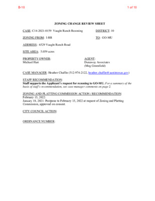
ZONING CHANGE REVIEW SHEET CASE: C14-2021-0159 Vaught Ranch Rezoning DISTRICT: 10 ZONING FROM: I-RR TO: GO-MU ADDRESS: 6529 Vaught Ranch Road SITE AREA: 5.059 acres PROPERTY OWNER: Michael Hart AGENT: Dunaway Associates (Meg Greenfield) CASE MANAGER: Heather Chaffin (512-974-2122, heather.chaffin@austintexas.gov) STAFF RECOMMENDATION: Staff supports the Applicant’s request for rezoning to GO-MU. For a summary of the basis of staff’s recommendation, see case manager comments on page 2. ZONING AND PLATTING COMMISSION ACTION / RECOMMENDATION: February 15, 2022: January 18, 2021: Postpone to February 15, 2022 at request of Zoning and Platting Commission, approved on consent. CITY COUNCIL ACTION: ORDINANCE NUMBER: 1 of 10B-10 C14-2021-0159 2 ISSUES: A portion of the property is located within the 100 year flood plain, and the remainder of the property is located within Critical Water Quality and Water Quality Transition Zones (CWQZ and WQTZ). The majority of the property is located in the WQTZ and is therefore limited by Code to 18% impervious cover. Consequently, the rezoning is primarily requested to determine land uses, setbacks and building height. Please see Exhibit C- Applicant Letter. CASE MANAGER COMMENTS: The subject property is located on the south side of FM 969 approximately 2 miles west of Loop 360. The existing I-RR zoning was applied to the property when the area was annexed in 2007. The undeveloped property is located within the West Bull Creek watershed and subject to Water Supply Suburban regulations and is also subject to Hill Country Roadways and Scenic Roadways zoning overlays. Although the property is addressed on Vaught Ranch Road, access to the road is not possible. The subject property will take access to FM 2222. Surrounding properties to the south, west and east are zoned I-RR and RR, as well as unzoned property in the ETJ. Significant portions of the surrounding area are undeveloped but there are some developed properties in the area. Land uses in the I-RR zoned area include medical offices, professional offices, multifamily residential and an electric substation. Properties in the RR zoned area are single family residential. Across FM 2222 to the north are properties zoned PUD, LR and GR-CO These properties include a mix of commercial and office land uses. Please see Exhibits A and B—Zoning Map and Aerial Exhibit. Staff supports the rezoning request to GO-MU. As stated in the Issues section, the creek buffers and floodplain significantly constrain development on the site. Additionally, City regulations limit the majority of the site to 18% impervious cover; other parts of the site (in the CWQZ and floodplain) are even more prohibitive. The site is also subject to Hill Country Roadway and Scenic Roadway design standards which supersede the base GO zoning. Rezoning will allow a range of office and residential uses which are consistent with those uses in the vicinity. Compared to the existing I-RR zoning, GO-MU allows for a more reasonable use of the property. BASIS FOR RECOMMENDATION 1. 2. Zoning should allow for reasonable use of the property. Granting of the request should result in an equal treatment of similarly situated properties. The I-RR zoning that was applied to properties in this area at time of annexation significantly limits any development on the property. GO-MU would offer the flexibility to develop office and/or residential uses that are comparable to the uses in the area. The rezoning would also be consistent with zonings that have been granted in the area. EXISTING ZONING AND LAND USES: ZONING Site North I-RR PUD; LR; GR-CO LAND USES Multifamily residences (total of 338 units) Offices, Financial services, Pet services, Restaurant uses within the Canyon Ridge PUD; Child care facility, Medical office, Business office, Restaurants, Personal 2 of 10B-10 C14-2021-0159 3 South East West services (Jester Village Shopping Center) I-RR; County Undeveloped County; DR; LR-CO Undeveloped, Multifamily residential I-RR, RR Medical office, Professional office, Electric substation, Single family residential SCENIC ROADWAY: Yes TIA: Deferred to site plan, if triggered AREA STUDY: Not Applicable WATERSHED: West Bull Creek – Water Supply Suburban CAPITOL VIEW CORRIDOR: No HILL COUNTRY ROADWAY: Yes – Moderate Intensity SCHOOLS: Highland Park Elementary School Lamar Middle School NEIGHBORHOOD ORGANIZATIONS: Lakewood Homeowners Association Bull Creek Homeowners Association 2222 Coalition of Neighborhood Associations, Inc. Bull Creek Foundation Jester Homeowners Association, Inc. Steiner Ranch Community Association Lake Austin Collective Mountain Neighborhood Association (MNA) River Place HOA Canyon Creek H.O.A. Austin Lost and Found Pets Long Canyon Phase II & Phase III Homeowners Association, Inc. TNR BCP – Travis County Natural Resources AREA CASE HISTORIES: McCallum High School Glenlake Neighborhood Association Long Canyon Homeowners Association AISD Save Our Springs Alliance Sierra Club, Austin Regional Group SEL Texas Friends of Austin Neighborhoods Westminster Glen HOA NUMBER C14-2021-0184 7201 FM 2222 Rd C14-2017-0067 – Champion Tract 1C – 6500 RM 2222 Rd REQUEST I-RR to MF-4- CO LR-CO to CS- CO COMMISSION Scheduled for 1-18- 2022 12-5-2017 – Denied CS-CO CITY COUNCIL To be scheduled 5-10-2018 – Apvd CS- CO w/CO limiting development to the trip allocation allotted by Ordinance No. 000309-80, list of conditional and prohibited uses, and identifying remaining 1,148 trips for other 3 of 10B-10 C14-2021-0159 4 C14-2010-0163 – Austin Cribs – 6320 City Park Rd DR to LR 01-18-2011 – Apvd LR-CO C14-05-0158 – Champion Tract – City Park Road West; City Park Rd. C14-02-0181 – Champion Tract – City Park Road West, 6404 City Park Rd C14-99-0077 – 6100-6404 City Park Rd – Champion Tract 2 LR-CO and DR to GO-CO and LR-CO 11-1-2005 – Apvd GR- MU-CO DR and LR-CO to GR-MU 1-14-2003 – Apvd LR- CO; R-O-W dedication DR to GR 8-31-1999 – Apvd Staff rec of GR-MU- CO EXISTING STREET CHARACTERISTICS: dev’t. 02-17-2011 – Apvd LR-CO w/CO max 500 vpd; prohibit drive-in services as an accessory use. Case Expired – did not have 3rd Reading within 360 days of 1st Reading. 12-2-2004 – Zoning change denied. 3-09-2000 – Apvd LR- CO w/CO for 6,500 adjusted trips/day, retail limited to 4,000 sf OTHER STAFF COMMENTS: Comprehensive Planning Connectivity There are no public transit stops, public sidewalks, bike lanes or crosswalks located along this section of FM 2222 or Vaught Ranch Road. Vaught Ranch Road is a narrow unimproved road, with no curbing or public sidewalks. FM 2222 has two lanes going each direction and is a major arterial corridor in this area of Austin. Mobility options in the area are below average, while connectivity options are fair, necessitating the use of a car to access nearby goods, services, civic uses, and other amenities. Imagine Austin The property is not located along an Activity Corridor or within/near and Activity Center. The overall goal of the Imagine Austin Comprehensive Plan (IACP) is to achieve ‘complete communities’ across Austin, where housing, services, retail, jobs, entertainment, health care, schools, parks, and other daily needs are within a convenient walk or bicycle ride of one another. On page 107 in Chapter 4 of the IACP it states, “While most new development will 4 of 10B-10 C14-2021-0159 5 be absorbed by centers and corridors, development will happen in other areas within the city limits to serve neighborhood needs and create complete communities. Infill development can occur as redevelopment of obsolete office, retail, or residential sites or as new development on vacant land within largely developed areas. New commercial, office, larger apartments, and institutional uses such as schools and churches, may also be located in areas outside of centers and corridors. The design of new development should be sensitive to and complement its context. It should also be connected by sidewalks, bicycle lanes, and transit to the surrounding area and the rest of the city.” The following IACP policies are also applicable to this case: LUT P3. Promote development in compact centers, communities, or along corridors that are connected by roads and transit that are designed to encourage walking and bicycling, and reduce health care, housing and transportation costs. LUT P7. Encourage infill and redevelopment opportunities that place residential, work, and retail land uses in proximity to each other to maximize walking, bicycling, and transit opportunities. Based upon this property being located along a major arterial corridor but the below average mobility and fair connectivity options in the area, this proposal partially supports the policies of the Imagine Austin Comprehensive Plan. Drainage The developer is required to submit a pre- and post-development drainage analysis at the subdivision and site plan stage of the development process. The City’s Land Development Code and Drainage Criteria Manual require that the Applicant demonstrate through engineering analysis that the proposed development will have no identifiable adverse impact on surrounding properties. There is a regional water quality / detention facility that will serve this site, therefore onsite drainage facilities will not be provided. Environmental The site is not located over the Edwards Aquifer Recharge Zone. The site is in the West Bull Creek Watershed of the Colorado River Basin, which is classified as a Water Supply Suburban Watershed by Chapter 25-8 of the City's Land Development Code. It is in the Drinking Water Protection Zone. Under the current watershed regulations, development or redevelopment on this site will be subject to the following impervious cover limits: Development Classification One or Two Family Residential 30% 40% Multifamily Residential 40% Commercial % of Net Site Area % NSA with Transfers 40% 55% 55% Development within a Water Quality Transition Zone is limited to 18%. According to floodplain maps there is a floodplain within and adjacent to the project location. Standard landscaping and tree protection will be required in accordance with LDC 25-2 and 25-8 for all development and/or redevelopment. 5 of 10B-10 C14-2021-0159 6 Under current watershed regulations, development or redevelopment requires water quality control with increased capture volume and control of the 2-year storm on site. PARD – Planning & Design Review PR1: Parkland dedication will be required for any new residential units proposed by this development, mixed use with GO-MU zoning, at the time of subdivision or site plan, per City Code § 25-1-601. Whether the requirement shall be met with fees in-lieu or dedicated land will be determined using the criteria in City Code Title 25, Article 14, as amended. Should fees in-lieu be required, those fees shall be used toward park investments in the form of land acquisition and/or park amenities within the surrounding area, per the Parkland Dedication Operating Procedures § 14.3.11 and City Code § 25-1-607 (B)(1) & (2). If the applicant wishes to discuss parkland dedication requirements in advance of site plan or subdivision applications, please contact this reviewer: thomas.rowlinson@austintexas.gov. At the applicant’s request, PARD can provide an early determination of whether fees in-lieu of land will be allowed. Site Plan SP 1 Site plans will be required for any new development other than single-family or duplex residential. SP 2 Any new development is subject to Subchapter E. Design Standards and Mixed Use. Additional comments will be made when the site plan is submitted. Hill Country Roadway A portion of the site is located within 1,000 feet of RM 2222 and within the moderate intensity zone of a Hill Country Roadway Corridor. The site may be developed with the following maximum floor-to-area ratio (FAR): Slope Maximum FAR 0-15% 15-25% 25-35% Except for clearing necessary to provide utilities or site access, a 100-foot vegetative buffer will be required along RM 2222. At least 40% of the site (excluding dedicated right-of-way) must be left in a natural state. The allowable height is as follows: Within 200 feet of RM 2222, the maximum height is 28 feet, and beyond 200 feet the maximum height is 40 feet in a moderate intensity zone. 0.25 0.10 0.05 This site is within the Wildland / Urban Interface and will need additional related review. Please reference https://www.austintexas.gov/department/wildland-urban-interface-code for additional information. Austin Transportation Department Assessment of required transportation mitigation, including the potential dedication of right of way and easements and participation in roadway and other multi-modal improvements, will occur at the time of site plan application. A traffic impact analysis shall be required at the time of site plan if triggered per LDC 25-6-113. There is a proposed Urban Trail adjacent to this site, along FM 2222 RD. The easement required is a minimum of 20 ft as this allows for a 12 ft trail (minimum trail width per the 6 of 10B-10 C14-2021-0159 7 urban trails plan) and room for maintenance activity. This is the same for Tier I and Tier II trails. ROW and access of FM 2222 RD must be referred to TxDOT. Existing adjacent street characteristics table is provided below: Water / Wastewater The landowner intends to serve the site with City of Austin water and wastewater utilities. The landowner, at own expense, will be responsible for providing any water and wastewater utility improvements, offsite main extensions, utility relocations and or abandonments required by the land use. The water and wastewater utility plan must be reviewed and approved by Austin Water for compliance with City criteria and suitability for operation and maintenance. Depending on the development plans submitted, water and or wastewater service extension requests may be required. All water and wastewater construction must be inspected by the City of Austin. The landowner must pay the City inspection fee with the utility construction. The landowner must pay the tap and impact fee once the landowner makes an application for a City of Austin water and wastewater utility tap permit. INDEX OF EXHIBITS: A: Zoning Map B. Aerial Exhibit C. Applicant Letter 7 of 10B-10 CUESTA TRL SF-2 SPC-04-0022A LO-MU-CO C14-2016-0096 C14-03-0128 SP-05-1219B 03-0128 EXHIBIT A ( C7A-00-004 C814-89-0006 NO NO R N T AIN D U O E L L M B RR ( V O C T L A R E P ( ( ( ( ENTRADA CV ( RR ( ( N D R G C A N Y O ( N L O ( RR I-RR ! ! ! ! ! ! ( ! ! ! ! ! ! ! ! ! ! ! ! ! ! ! ! ! ! ! ! ! ! ! ! ! ! ! ! ! ! ! ! ! ! ! ! ! ! RR ! ! ! ! ! ! ! ! ! ! ! ! ! ! ! ! ! ! ! ! ! ! ! ! ! ! 86-020 D H R C N A T R H G U VA I-RR ( ( ( PUD C814-89-0006.04 SPC-05-0024C SP-93-0296C SF-2 ( ( ( ( UNDEV UNDEV UNDEV D L V R B E T S J E C14-97-0162 LR UNDEV F M 2 2 2 2 R D ± SUBJECT TRACT ! ! ! ! ! ! PENDING CASE ZONING BOUNDARY C7a-07-018 ZONING ZONING CASE#: C14-2021-0159 This product is for informational purposes and may not have been prepared for or be suitable for legal, engineering, or surveying purposes. It does not represent an on-the-ground survey and represents only the approximate relative location of property boundaries. 1 " = 400 ' This product has been produced by the Housing and Planning Department for the sole purpose of geographic reference. No warranty is made by the City of Austin regarding specific accuracy or Created: 9/22/2021 8 of 10B-10 SF-2 LO-MU-CO NO R T AIN D NO F M 2 2 2 2 R D I-RR N U O E L L M B RR V O C T L A R E P ENTRADA CV RR L O N G C A N Y O N D R RR D H R C N A T R H G U VA F31 RR C14-2021-0159 F M 2 2 2 2 R D I-RR EXHIBIT B SF-2 PUD E T S J E D R B L V GR-CO LR Copyright nearmap 2015 ± 1'' = 400' C14-2021-0159 Creek Buffers ZONING BOUNDARY FULLY DEVELOPED FLOODPLAIN Vaught Ranch Rezoning ZONING CASE#: LOCATION: SUBJECT AREA: GRID: MANAGER: C14-2021-0159 6529 Vaught Ranch Rd 5.059 Acres F31 Heather Chaffin This map has been produced by the Communications Technology Management Dept. on behalf of the Planning Development Review Dept. for the sole purpose of geographic reference. No warranty is made by the City of Austin regarding specific accuracy or completeness. 9 of 10B-10 EXHIBIT C 10 of 10B-10