B-09 (C14-2021-0184 - 7201 FM Road 2222; District 10).pdf — original pdf
Backup
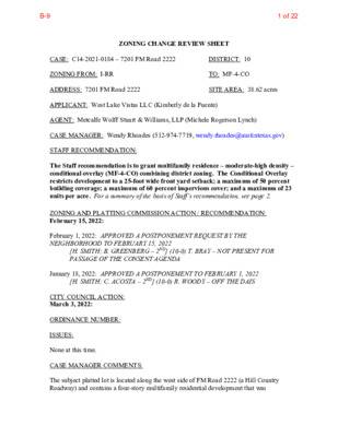
ZONING CHANGE REVIEW SHEET DISTRICT: 10 TO: MF-4-CO SITE AREA: 38.62 acres CASE: C14-2021-0184 – 7201 FM Road 2222 ZONING FROM: I-RR ADDRESS: 7201 FM Road 2222 APPLICANT: West Lake Vistas LLC (Kimberly de la Fuente) AGENT: Metcalfe Wolff Stuart & Williams, LLP (Michele Rogerson Lynch) CASE MANAGER: Wendy Rhoades (512-974-7719, wendy.rhoades@austintexas.gov) STAFF RECOMMENDATION: The Staff recommendation is to grant multifamily residence – moderate-high density – conditional overlay (MF-4-CO) combining district zoning. The Conditional Overlay restricts development to a 25-foot wide front yard setback; a maximum of 50 percent building coverage; a maximum of 60 percent impervious cover; and a maximum of 23 units per acre. For a summary of the basis of Staff’s recommendation, see page 2. ZONING AND PLATTING COMMISSION ACTION / RECOMMENDATION: February 15, 2022: February 1, 2022: APPROVED A POSTPONEMENT REQUEST BY THE NEIGHBORHOOD TO FEBRUARY 15, 2022 [H. SMITH; B. GREENBERG – 2ND] (10-0) T. BRAY – NOT PRESENT FOR PASSAGE OF THE CONSENT AGENDA January 18, 2022: APPROVED A POSTPONEMENT TO FEBRUARY 1, 2022 [H. SMITH; C. ACOSTA – 2ND] (10-0) R. WOODY – OFF THE DAIS CITY COUNCIL ACTION: March 3, 2022: ORDINANCE NUMBER: ISSUES: None at this time. CASE MANAGER COMMENTS: The subject platted lot is located along the west side of FM Road 2222 (a Hill Country Roadway) and contains a four-story multifamily residential development that was 1 of 22B-9 C14-2021-0184 Page 2 constructed in three phases and appears to have been completed in 2009. A segment of Bull Creek extends across the FM 2222 frontage and a tributary runs in a north – south direction through the property’s eastern half. Driveway access to FM 2222 aligns with Jester Boulevard on the north side. The zoning area and adjacent lots were annexed into the City limits in December 2007 and zoned interim – rural residence (I-RR) at that time. In November 2006, prior to annexation, a “D” (non-land use) site plan was approved for the multifamily residences (SP-06-0592D). Please refer to Exhibit B (Approved Site Plan). The zoning area is surrounded by an undeveloped lot owned by the City and another undeveloped L-shaped lot approximately 560 feet to the north that is privately owned and proposed for GO-MU zoning (both currently I-RR); office and commercial uses across FM 2222 to the east (PUD; GR-CO; LR); undeveloped land to the south (County; DR; LR-CO), and undeveloped land owned by the City to the west (I-RR; County). Please refer to Exhibits A (Zoning Map) and A-1 (Aerial Exhibit). The Applicant requests multifamily residence – moderate-high density – conditional overlay (MF-4-CO) district zoning consistent with the existing four-story apartments. The requested Conditional Overlay establishes multifamily residence – low density (MF-2) development standards for the property (front yard setback, building coverage, impervious cover and maximum units per acre) except for height which will remain at 60 feet to account for the existing four-story buildings. Note that the property’s location on a Hill Country Roadway and within the West Bull Creek Watershed prescribe more restrictive development standards than those listed above and would apply if redevelopment were to occur. That is, the base zoning district does not waive or exempt the property from complying with Hill Country Roadway or the watershed-specific regulations. BASIS FOR RECOMMENDATION 1. The proposed zoning should be consistent with the purpose statement of the district sought. The multi-family residence – moderate-high density (MF-4) district is intended for residential and multi-family use with a maximum density of up to 54 units per acre, depending on unit size and mix. This district is appropriate for multi-family residential areas located near supporting transportation and commercial facilities, generally in more centrally located areas. The Conditional Overlay (CO) combining district may be applied in combination with any base district. The district is intended to provide flexible and adaptable use or site development regulations by requiring standards tailored to individual properties. The property takes access to FM Road 2222, a major arterial roadway. 2. Intensive multi-family zoning should be located on highways and major arterials. 3. Zoning changes should promote compatibility with adjacent and nearby uses. 4. The proposed zoning should allow for a reasonable use of the property. Staff recommends MF-4-CO zoning for the property based on the following considerations: 1) multifamily residential development is appropriate on FM 2222, an arterial (Level 4) road, 2 of 22B-9 C14-2021-0184 Page 3 2) it brings the existing development into compliance with the zoning regulations, and 3) with the exception of height, the Conditional Overlay accounts for the existing development and limits development to MF-2 zoning standards. EXISTING ZONING AND LAND USES: Site I-RR ZONING North I-RR LAND USES Multifamily residences (total of 338 units in the West Lake Vistas apartments; 1 bedroom – 155 units; 2 bedroom – 183 units) Undeveloped (Lot 3, owned by City); Undeveloped (proposed for GO-MU zoning) South County; DR; LR-CO Undeveloped East PUD; LR; GR-CO Offices, Financial services, Pet services, Restaurant uses within the Canyon Ridge PUD; Child care facility, Medical office, Business office, Restaurants, Personal services within the Jester Village Shopping Center Undeveloped (Lot 1, owned by City) West I-RR; County TIA: Is not required SCENIC ROADWAY: Yes AREA STUDY: Not Applicable WATERSHED: West Bull Creek – Water Supply Suburban CAPITOL VIEW CORRIDOR: No HILL COUNTRY ROADWAY: Yes – Moderate Intensity SCHOOLS: Highland Park Elementary School Lamar Middle School COMMUNITY REGISTRY LIST: 98 – Lakewood Homeowners Association 184 – Bull Creek Homeowners Association 269 – Long Canyon Homeowners Association 416 – Long Canyon Phase II & Phase III Homeowners Association, Inc. 425 – 2222 Coalition of Neighborhood Associations, Inc. 475 – Bull Creek Foundation 608 – Jester Homeowners Association, Inc. 742 – Austin Independent School District 762 – Steiner Ranch Community Association 943 – Save Our Springs Alliance 1169 – Lake Austin Collective 1260 – Mountain Neighborhood Association (MNA) 1463 – River Place HOA 1564 – Canyon Creek H.O.A. 1603 – Westminster Glen HOA 1596 – TNR BCP – Travis County Natural Resources 1228 – Sierra Club, Austin Regional Group 1363 – SEL Texas 161 – Glenlake Neighborhood Association 1530 – Friends of Austin Neighborhoods 1774 – Austin Lost and Found Pets McCallum High School 3 of 22B-9 C14-2021-0184 Page 4 AREA CASE HISTORIES: NUMBER C14-2021-0159 – 6529 Vaught Ranch Rd – Vaught Ranch Rezoning C14-2017-0067 – Champion Tract 1C – 6500 RM 2222 Rd REQUEST COMMISSION I-RR to GO-MU Scheduled for 1-18- CITY COUNCIL To be scheduled 2022 LR-CO to CS- CO 12-5-2017 – Denied CS-CO 5-10-2018 – Apvd CS- CO w/CO limiting development to the trip allocation allotted by Ordinance No. 000309-80, list of conditional and prohibited uses, and identifying remaining 1,148 trips for other dev’t. 02-17-2011 – Apvd LR-CO w/CO limiting trips to 500 / day; prohibit drive-in services as an accessory use. Case Expired – did not have 3rd Reading within 360 days of 1st Reading. C14-2010-0163 – Austin Cribs – 6320 City Park Rd DR to LR 01-18-2011 – Apvd LR-CO C14-05-0158 – Champion Tract – City Park Road West; City Park Road C14-02-0181 – Champion Tract – City Park Road West, 6404 City Park Rd C14-99-0077 – 6100-6404 City Park Rd – Champion Tract 2 LR-CO and DR to GO-CO and LR-CO 11-1-2005 – Apvd GR- MU-CO DR and LR-CO to GR-MU 1-14-2003 – Apvd LR- CO; R-O-W dedication 12-2-2004 – Zoning change denied. DR to GR 8-31-1999 – Apvd Staff rec of GR-MU- CO 3-09-2000 – Apvd LR- CO w/CO for 6,500 adjusted trips/day, retail limited to 4,000 sf RELATED CASES: The property was annexed into the Full purpose City limits on December 31, 2007 and assigned I-RR zoning (C7a-07-018 – Ordinance No. 20071108-029). 4 of 22B-9 C14-2021-0184 Page 5 The zoning area is platted as Lot 2, Block A, Vaught Ranch Section Two, a subdivision recorded on May 25, 2006 (C8J-05-0160.0A – Vaught Ranch Sec. 2). The 38.62 acre zoning area is included in the Alexan at Vaught Ranch (Resubmittal of SP- 05-1499D) site plan approved and released on November 29, 2006 (SP-06-0592D). The approved site plan also included the adjacent, City-owned Lots 1 and 3 in order to create a cohesive development on 89.5 acres, and is subject to a recorded Restrictive Covenant for an Integrated Pest Management (IPM) Control Plan. On May 16, 2006, the Zoning and Platting Commission approved variances for construction of a utility in the Critical Water Quality Zone (LDC 25-8-261(E)); exceeding cut / fill maximums (Title 30-5-341/342); and construction on slopes greater than 15 percent (Title 30-5-302(A)). As information, a Development Permit “D” site plan does not include a land use element because the subject property was within the Extra-Territorial Jurisdiction at the time of application. Also, a complete site plan application was filed with the City before the date the annexation proceedings were instituted, and the Applicant has continuation of land use rights, as outlined in Section 43.002 of the Texas Local Government Code. The City allows for the development of properties to be completed in accordance with the site plan on file, without requiring zoning consistent with the existing uses. EXISTING STREET CHARACTERISTICS: Name ROW Pavement Classification Sidewalks Bicycle Route Capital Metro (within ¼ mile) Level 4 (Major Arterial Divided); Hill Country Road w/42,000 vpd FM Road 2222 248 feet 85 feet No Shoulder No OTHER STAFF COMMENTS: Comprehensive Planning This zoning case is located on the west side of FM 2222. The parcel is approximately 38.6 acres in size and contains several large apartment buildings on the site. The property is not located within a neighborhood planning area, nor it is located along an Activity Corridor or within or near an Activity Center. Surrounding land uses includes office and residential uses to the north, to the south and west is undeveloped land; and to the east are office and commercial uses. Per the agent, the property was annexed into the City of Austin in 2007 with an approved multifamily site plan, and the property was zoned I-RR upon annexation. This zoning will acknowledge what has been on the property for years, specifically a multifamily land use. 5 of 22B-9 C14-2021-0184 Page 6 Connectivity There are no public sidewalks, bike lanes, or public transit options available along this portion of FM 2222. Although there are commercial and office uses located on the other side of FM 2222, there are no crosswalks to access them along this busy highway. Mobility options in the area are below average while connectivity is mediocre because it necessitates a car to access them. Imagine Austin The property is not located along an Activity Corridor or within an Activity Center. The following IACP policies are applicable to this case: • LUT P3. Promote development in compact centers, communities, or along corridors that are connected by roads and transit that are designed to encourage walking and bicycling, and reduce health care, housing and transportation costs. • LUT P7. Encourage infill and redevelopment opportunities that place residential, work, and retail land uses in proximity to each other to maximize walking, bicycling, and transit opportunities. Please note that the Imagine Austin compliance review does not include specific policy focus on environmental and/or water quality. Analyzing the land uses within a one mile of radius of this subject property, there appears to be both benefits and challenges to this location. Most importantly, this area of Austin lacks a variety of goods and services for nearby residents and office workers to safely access them via public sidewalks, bike lanes or public transit within several miles of this location. Based on the apartment buildings already existing on the site but mobility weaknesses in this area, this zoning only partially supports the Imagine Austin Comprehensive Plan. Drainage As information, the developer is required to submit a pre- and post-development drainage analysis at the subdivision and site plan stage of the development process. The City’s Land Development Code and Drainage Criteria Manual require that the Applicant demonstrate through engineering analysis that the proposed development will have no identifiable adverse impact on surrounding properties. Environmental The site is not located over the Edwards Aquifer Recharge Zone. The site is in the West Bull Creek Watershed of the Colorado River Basin, which is classified as a Water Supply Suburban Watershed by Chapter 25-8 of the City's Land Development Code. It is in the Drinking Water Protection Zone. Under the current watershed regulations, redevelopment on this site will be subject to the following impervious cover limits: 6 of 22B-9 C14-2021-0184 Page 7 Development Classification One or Two Family Residential 30% 40% Multifamily Residential 40% Commercial % of Net Site Area % NSA with Transfers 40% 55% 55% Development within a Water Quality Transition Zone is limited to 18%. According to floodplain maps there is a floodplain within and adjacent to the project location. Based upon the location of the floodplain, offsite drainage should be calculated to determine whether a Water Quality Transition Zone / Critical Water Quality Zone exist within the project location. Standard landscaping and tree protection will be required in accordance with LDC 25-2 and 25-8 for all development and/or redevelopment. Under current watershed regulations, development or redevelopment requires water quality control with increased capture volume and control of the 2-year storm on site. Impervious Cover Within the West Bull Creek watershed, the maximum impervious cover allowed by the MF-4 zoning district is 40% (55% with transfers), which is based on the more restrictive watershed regulations. The approved site plan is for 89.5 acres and covers Lot 1 (owned by the City), Lot 2 (the zoning area) and Lot 3 (also owned by the City). Of the 10.1 acres of allowed impervious cover, Lot 2 contains 7.4 acres (8.27 percent). There is a remainder of 2.7 acres of impervious cover allowed on Lots 1 and 3 where no development is proposed. Steep slopes would potentially limit further use of remaining impervious cover. PARD – Planning & Design Review Parkland dedication may be required at the time of a future subdivision or site plan for any proposed residential units, or any that have not previously satisfied the requirement, per City Code § 25-1-601. If the applicant wishes to discuss parkland dedication requirements in advance of any potential future site plan or subdivision applications, please contact this reviewer: thomas.rowlinson@austintexas.gov. At the applicant’s request, PARD can provide an early determination of the requirements. Site Plan Site plans will be required for any new development other than single-family or duplex residential. 7 of 22B-9 C14-2021-0184 Page 8 Any development which occurs in an SF-6 or less restrictive zoning district which is located 540-feet or less from property in an SF-5 or more restrictive zoning district will be subject to compatibility development regulations. Any new development is subject to Subchapter E: Design Standards and Mixed Use. Additional comments will be made when the site plan is submitted. Compatibility Standards The site is subject to compatibility standards due to a SF-2 lot located approximately 410 feet from the southeast property line (on the north side of RM Road 2222). Slope 0-15% 15-25% 25-35% Hill Country Roadway A portion of the site is located within 1,000 feet of RM 2222 and within the moderate intensity zone of a Hill Country Roadway Corridor. The site may be developed with the following maximum floor-to-area ratio (FAR): Except for clearing necessary to provide utilities or site access, a 100-foot vegetative buffer will be required along RM 2222 with any redevelopment. At least 40% of the site (excluding dedicated right-of-way) must be left in a natural state. The allowable height is as follows: Within 200 feet of RM 2222, the maximum height is 28 feet, and beyond 200 feet the maximum height is 40 feet in a moderate intensity zone. Please note that the site was in the ETJ at the time a site plan was approved and released on the property, and Hill Country Roadway requirements did not apply. Maximum FAR 0.25 0.10 0.05 This site is within the Wildland / Urban Interface and will need additional related review. Please reference https://www.austintexas.gov/department/wildland-urban-interface-code for additional information. Austin Transportation Department Transportation Assessment Assessment of required transportation mitigation, including the potential dedication of right of way and easements and participation in roadway and other multi-modal improvements, will occur at the time of new site plan application. A traffic impact analysis shall be required at the time of site plan if triggered per LDC 25-6-113. Water / Wastewater The landowner intends to serve the site with City of Austin water and wastewater utilities. The landowner, at own expense, will be responsible for providing any water and wastewater utility improvements, offsite main extensions, utility relocations and or abandonments required by the land use. The water and wastewater utility plan must be reviewed and 8 of 22B-9 C14-2021-0184 Page 9 approved by Austin Water for compliance with City criteria and suitability for operation and maintenance. Depending on the development plans submitted, water and or wastewater service extension requests may be required. All water and wastewater construction must be inspected by the City of Austin. The landowner must pay the City inspection fee with the utility construction. The landowner must pay the tap and impact fee once the landowner makes an application for a City of Austin water and wastewater utility tap permit. INDEX OF EXHIBITS AND ATTACHMENTS TO FOLLOW: A: Zoning Map A-1: Aerial Map B: Approved Site Plan (2006) Applicant’s correspondence Public communication Questions and Answers 9 of 22B-9 ! ! ! ! ! ! ! ! ! ! ! ! ! ! ! ! ! ! ! ! ! ! ! ! ( ! ! ! ! ! ! ! ! ! ! ! ! ! ! ! ! ! ! ! ! D H R C N A T R H G U VA ! ! ! RR ! ! ! ! ! ! ! ! ! ! ! ! ! ! ! ! ! ! ! ! ! ! ! R N D O Y N A RR G C N L O ( RR ( ! ! ! ! ! ! ! ! ! ! ! ! ! ! ! ! ! ! ! ! ! ! ! ! ! ! ! ! ! ! ! ! ! ! ! ! ! ! ! ! ! ! ! ! ! ! ! ! ! ! ! ! ! ! ! ! ! ! ! ! ! ! ! ! ! ! ! ! ! ! ! ! ! ! UNDEV I-RR ! ! ! C7a-07-018 ! ! SP-93-0296C UNDEV PUD C814-89-0006.04 UNDEV D L V R B E T S J E 97-0162 GR-CO C14-97-0162 UNDEV LR ! ! ! ! ! F M 2 2 2 2 R D ! ! ! ! ! ! ! ! ! ! ! ! ! ! SP-06-0009D ! ! ! ! ! ! ! ! ! ! ! ! ! ! ! ! ! ! ! ! ! ! ! ! ! ! ! ! ! ! ! ! ! ! ! ! ! ! !! DR LR-CO CITY PARK R D C14-2015-0160 GO-CO ± SUBJECT TRACT ! ! ! ! ! ! PENDING CASE ZONING BOUNDARY I-RR CITY PARK RD ZONING Exhibit A ZONING CASE#: C14-2021-0184 This product is for informational purposes and may not have been prepared for or be suitable for legal, engineering, or surveying purposes. It does not represent an on-the-ground survey and represents only the approximate relative location of property boundaries. 1 " = 400 ' This product has been produced by the Housing and Planning Department for the sole purpose of geographic reference. No warranty is made by the City of Austin regarding specific accuracy or Created: 12/6/2021 10 of 22B-9 Exhibit A - 1 182931591411231212413916481361605711517403238347810636244333367A12595853372161092413229131613353415141111301453151C14-2021-0184PUDRRI-RRLR-COGO-COSF-2SF-2SF-2RRI-RRRRGR-COMF-2GR-COSF-2MF-1-COSF-2GR-COI-RRLRDRCITY PARK RDENTRADA CVFERN SPRINGCVFM 2222 RDFM2222 RDJESTERBLVDJESTERBLVDVAUGHT RANCH RDLONG CANYON DRCITYPARK RDF31F30Copyrightnearmap 2015This map has been produced by the Communications Technology Management Dept. on behalf of thePlanning Development Review Dept. for the sole purpose of geographic reference. No warranty is madeby the City of Austin regarding specific accuracy or completeness.ZONING CASE#:LOCATION:SUBJECT AREA:GRID:MANAGER:C14-2021-01847201 FM 2222 ROAD38.6213 ACRESF31WENDY RHOADES1'' = 500'ZONING BOUNDARYCREEK BUFFERPENDING CASE!!!!!!SUBJECT TRACT7201 FM 2222 ROAD11 of 22B-9 Exhibit B 12 of 22B-9 13 of 22B-9 14 of 22B-9 15 of 22B-9 MICHELE ROGERSON LYNCH Director of Land Use & Entitlements mlynch@mwswtexas.com 512-404-2251 November 23, 2021 Via Online Submittal Mr. Jerry Rusthoven, Zoning Officer Housing and Planning Department 505 Barton Springs Road, 5th Floor Austin, Texas 78704 Re: Dear Mr. Rusthoven: Application for Zoning; 38.6 acres located at 7201 FM RD 2222 (the “Property”). As representatives of the owner of the above stated Property we respectfully submit the attached Application for Zoning. The Property is located at 7201 FM RD 2222 (see Location Map attached) and is not located in a Neighborhood Plan. The Application for Zoning requests to zone the Property from Interim-Rural Residential (I-RR) to Multifamily Residence Moderate-high Density – Conditional Overlay Combining District (MF-4-CO). A site plan for the existing multifamily development was approved while in the City of Austin’s Extraterritorial Jurisdiction and was later annexed by the City of Austin in 2007. A temporary zoning category of I-RR was assigned at the time of annexation. The goal of this Application for Zoning is to establish permanent zoning to bring the existing development into compliance with City of Austin zoning regulations. A conditional overlay is proposed to limit the site to Multifamily Residence Low Density (MF-2) site development regulations except for height, which shall remain with the MF-4 site development regulation of 60 feet in height. The Property is not within any designated neighborhood plan. Surrounding zoning includes Neighborhood Commercial (LR), Limited Office (LO), Neighborhood Office (NO), Planned Unit Development (PUD), Multifamily-Limited Density (MF-1), and Single-Family Standard Lot (SF-2). A Traffic Impact Analysis is not required pursuant to the TIA Determination form attached to the Application for Rezoning. If you have any questions about this Application for Rezoning or need additional information, please do not hesitate to contact me at your convenience. Thank you for your time and attention to this project. Very truly yours, Michele Rogerson Lynch 221 W. 6th Street, Suite 1300, Austin, TX 78701 • 512.404.2200 • fax 512.404.2245 • www.mwswtexas.com 16 of 22B-9 ZONING EXHIBIT 17 of 22B-9 From: To: Subject: Date: Rhoades, Wendy Re: For ZAP 1-18-2022 C14-2021-0184 - 7201 FM Road 2222 Friday, January 14, 2022 3:00:36 PM *** External Email - Exercise Caution *** Wendy, On behalf of Lake Austin collective I will represent opposition to the consent of this item. Thank you, Linda Linda Bailey On Jan 14, 2022, at 10:52 AM, Rhoades, Wendy <Wendy.Rhoades@austintexas.gov> wrote: All, The Zoning and Platting Commission (ZAP) agenda and the Staff report is provided in the link below. I am offering the 7201 FM Road 2222 zoning case (Item B-9) as a consent item. Due to health and safety concerns in light of Austin’s return to Stage 5 of the pandemic, the ZAP Commission has indicated that they will only be taking action on cases ready for consent approval at next week’s meeting. It is likely that discussion cases will be postponed to February 1st. As information, at next Tuesday's meeting, ZAP is likely to discuss allowing for participation by phone in addition to in-person attendance. ZAP agenda: Font Size: 12 (austintexas.gov) Staff report (with page numbers): ZONING CHANGE REVIEW SHEET (austintexas.gov) Sincerely, Wendy Rhoades CAUTION: This email was received at the City of Austin, from an EXTERNAL source. Please use caution when clicking links or opening attachments. If you believe this to be a malicious and/or phishing email, please forward this email to cybersecurity@austintexas.gov. 18 of 22B-9 From: To: Cc: Subject: Date: Rhoades, Wendy King, David - BC Rivera, Andrew RE: C14-2021-0184 – 7201 FM Road 2222 Monday, January 31, 2022 4:50:00 PM Commissioner King, The site plan for the existing multifamily residential development was approved prior to annexation into the City limits and was not subject to (and does not comply with) the Hill Country Roadway requirements in Section 25-2 (Zoning). It also does not fully comply with the West Bull Creek (Water Supply Suburban) watershed requirements as explained in the Related Cases section on pages 4 – 5 of the backup. If the property is redeveloped in the future, it must comply with the zoning ordinance adopted by Council, as well as Hill Country Roadway, and West Bull Creek (Water Supply Suburban) watershed requirements. Please note that the strictest regulation will apply to new development. Sincerely, Wendy Rhoades From: King, David - BC <BC-David.King@austintexas.gov> Sent: Friday, January 28, 2022 9:33 AM To: Rhoades, Wendy <Wendy.Rhoades@austintexas.gov> Cc: Rivera, Andrew <Andrew.Rivera@austintexas.gov> Subject: C14-2021-0184 – 7201 FM Road 2222 Hello Wendy, Based on the following statement in staff backup for this case, will the proposed conditional overlay, proposed development, and staff recommendation, including the 60 feet height limit, comply with Hill Country Roadway and West Bull Creek Watershed requirements? "Note that the property’s location on a Hill Country Roadway and within the West Bull Creek Watershed prescribe more restrictive development standards than those listed above and would apply if redevelopment were to occur." Thank you, David David King Zoning and Platting Commission - District 5 19 of 22B-9 From: To: Subject: Date: Attachments: Rhoades, Wendy Denkler, Ann - BC FW: B2- 2222 Monday, January 31, 2022 7:17:00 PM Item B-2 C14-2021-0184 Elevation, Notes, Calculations .pdf.TIF Commissioner Denkler, Attached is another sheet from the approved site plan showing the building elevations (note that the building height is illegible to me), general notes, unit tabulations, density, and impervious cover calculations. Sincerely, Wendy Rhoades From: Rhoades, Wendy Sent: Monday, January 31, 2022 6:33 PM To: Denkler, Ann - BC <bc-Ann.Denkler@austintexas.gov> Cc: Rivera, Andrew <Andrew.Rivera@austintexas.gov> Subject: RE: B2- 2222 Commissioner Denkler, Please see my responses below. Sincerely, Wendy Rhoades From: Denkler, Ann - BC <bc-Ann.Denkler@austintexas.gov> Sent: Monday, January 31, 2022 12:09 PM To: Rivera, Andrew <Andrew.Rivera@austintexas.gov> Cc: Rhoades, Wendy <Wendy.Rhoades@austintexas.gov> Subject: B2- 2222 1. Please provide a copy of the site plan that was filed. RESPONSE: Please refer to the attached site plan. 2. Can the applicant indicate if any more buildings are planned? RESPONSE: No additional apartment buildings are planned, however, the Applicant reports that additional square footage may be needed for improvements to the onsite amenities such as a mail room, additional paving area for the fire lane, and coping / decking around the swimming pool. 3. Is the applicant going to ask for or use impervious cover transfers? RESPONSE: The Applicant does not intend to ask for impervious cover transfers, however, if additional impervious cover for onsite improvements is required as referenced above, it will need to be obtained from the two adjacent City-owned lots and will need to go through a City 20 of 22B-9 4. Is this case requiring an environmental variance? If so, why doesn't the posting reflect this? RESPONSE: The zoning case does not require an environmental variance. Environmental variances were considered with the site plan application which was approved by the Zoning and Platting Commission in November 2006. review process. Thanks, Ann Ann Denkler Boards and Commissions Scheduled Meeting Disclosure Information: Written disclosure is required by visitors when attending a scheduled meeting with a City Official regarding a municipal question for compensation on behalf of another person. Anyone scheduling or accepting a meeting invitation with a City Official must either acknowledge that the disclosure requirement does not apply or respond to the following survey: https://www.surveymonkey.com/r/BCVisitorLog IMPORTANT NOTICE: The City of Austin provides e-mail addresses for members of its boards and commissions for their use as board members. This address should not be used for private or personal messages. The views expressed in e-mail messages reflect the views of the authors alone, and do not necessarily reflect the views of any board or commission of which the author may be a member. In particular, the views expressed here do not necessarily reflect those of the City of Austin, or any of its departments, employees or officials. E-mail messages may be subject to required public disclosure under the Texas Public Information Act. 21 of 22B-9 From: To: Cc: Subject: Date: Rhoades, Wendy; Re: For ZAP 2-1-2022 C14-2021-0184 - 7201 FM Road 2222 Tuesday, February 1, 2022 2:32:53 PM *** External Email - Exercise Caution *** On Feb 1, 2022, at 1:10 PM, Michele Rogerson Lynch wrote: Wendy - my understanding is that Lake Austin Collective has asked for a 2 week postponement. I just let Linda know that I will not oppose. Michele, Thank you very much, Linda Bailey Thanks, M ----------------------------- Michele Rogerson Lynch Director of Land Use & Entitlements Metcalfe Wolff Stuart & Williams, LLP 221 W. 6th Street, Suite 1300 Austin, Texas 78701 (512) 404-2251 ofc (512) 797-2129 cell (512) 404-2244 fax On Jan 28, 2022, at 11:13 AM, Rhoades, Wendy <Wendy.Rhoades@austintexas.gov> wrote: The Zoning and Platting Commission (ZAP) agenda and the updated Staff report with all correspondence received to date are provided in the link below. The 7201 FM Road 2222 zoning case (Item B-2) is slated as a discussion item. Please refer to page 6 for a link to register in advance of the meeting to address the Commission. Page 7 includes information about parking validation and Speaker testimony time allocation. Staff report (with page numbers): ZONING CHANGE REVIEW SHEET (austintexas.gov) Please note, the ZAP meeting has the option of allowing the public to participate via telephone as well as in-person. In order to address the ZAP Commission by telephone, please be sure to sign up through the Commission Liaison Andrew Rivera prior to Noon on Monday, January 31st. In- person speakers are able to sign up anytime prior to the ZAP 6 p.m. start time. [Outside Email] All, Sincerely, Wendy Rhoades <Zoning and Platting Commission February 1 2022 Agenda.pdf> CAUTION: This email was received at the City of Austin, from an EXTERNAL source. Please use caution when clicking links or opening attachments. If you believe this to be a malicious and/or phishing email, please forward this email to cybersecurity@austintexas.gov. 22 of 22B-9