B-08 (C14-2021-0188 - 10817 Old San Antonio Road; District 5).pdf — original pdf
Backup
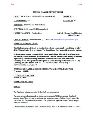
ZONING CHANGE REVIEW SHEET CASE: C14-2021-0188 – 10817 Old San Antonio Road ZONING FROM: SF-2 ADDRESS: 10817 Old San Antonio Road SITE AREA: 0.808 acres (35,196 square feet) PROPERTY OWNER: Caroline Riley DISTRICT: 5 ZONING TO: CS AGENT: Keepers Land Planning (Ricca Keepers) CASE MANAGER: Wendy Rhoades (512-974-7719, wendy.rhoades@austintexas.gov) STAFF RECOMMENDATION: The Staff recommendation is to grant neighborhood commercial – conditional overlay (LR-CO) combining district zoning. The Conditional Overlay prohibits service station. If the rezoning request is granted, it is recommended that 3 feet of right-of-way from the existing centerline should be dedicated for Old San Antonio Road and up to 9 feet of right-of-way from the existing centerline should be dedicated for Brezza Lane according to the Transportation Plan prior to Third Reading of the ordinance at City Council [LDC 25-6-51 and 25-6-55]. For a summary of the basis of Staff’s recommendation, see pages 2-3. ZONING AND PLATTING COMMISSION ACTION / RECOMMENDATION: February 15, 2022: CITY COUNCIL ACTION: March 24, 2022: ORDINANCE NUMBER: ISSUES: The Applicant is in agreement with the Staff recommendation. There are approved striping plans for the improvement of Old San Antonio Road and construction of Brezza Lane located near the southeast corner of Akins High School (SP- 2019-0161D – Brezza Lane Extension). The project was approved by the City on August 31, 2020 and included: - Southbound Left turn lane from Old San Antonio Road to its intersection with FM 1626 1 of 14B-8 C14-2021-0188 Page 2 - 6’ sidewalks and a 7’ shoulder on both sides of Old San Antonio Road from FM 1626 to approximately where Old San Antonio Road splits from Brezza Lane - Northbound Left turn lane from Brezza Lane onto Old San Antonio Road. Please refer to approved plan sheets at the back of this report. CASE MANAGER COMMENTS: The subject platted lot is located on Old San Antonio Road, a two-lane roadway just west of IH-35, approximately one mile south of Slaughter Lane. The property is located north of FM 1626, contains a single family residence and has had single family residence – standard lot (SF-2) zoning since its annexation into the City limits in 1997. Please refer to Exhibits A and A-1 – Zoning Map and Aerial Exhibit. The property is surrounded by an upholstery shop, private primary educational facility, and Akins High School football fields to the north (I-RR; LO-MU-CO); the extension of Brezza Lane (under construction) and undeveloped property to the east and south (GR-CO; CS-MU- CO); and Akins High School and outdoor athletic facilities, apartments and a City fire station and EMS facility to the west (I-RR; MF-3-CO; P). Old San Antonio Road is planned to connect with Brezza Lane approximately 270 feet to the south. The Applicant proposes to rezone the property to the general commercial services (CS) district so that it may be developed with a plant nursery and a restaurant. Access is proposed to be taken to both roadways and ATD staff does not have any access restrictions at this time. BASIS OF RECOMMENDATION: 1. The proposed zoning should be consistent with the purpose statement of the district sought. Staff Recommendation: The neighborhood commercial (LR) district is intended for shopping facilities that provide limited business services and offices to the residents of the neighborhood, such as consumer repair services, food sales, service stations, and pet services. The purpose statement listed in the City of Austin Land Development Code states: “The Neighborhood Commercial district is the designation for a commercial use that provides business service and office facilities for the residents of a neighborhood. Site development regulations and performance standards applicable to a LR district use are designed to ensure that the use is compatible and complementary in scale and appearance with the residential environment.” The Conditional Overlay (CO) combining district may be applied in combination with any base district. The district is intended to provide flexible and adaptable use or site development regulations by requiring standards tailored to individual properties. 2. Zoning changes should promote compatibility with adjacent and nearby uses. 3. Zoning should be consistent with approved and existing densities. The character of Old San Antonio Road has changed from primarily low density single family to one that allows for residential, commercial and civic uses and development. The property abuts a low intensity commercial use to the north and with right-of-way dedication 2 of 14B-8 C14-2021-0188 Page 3 will have access to Brezza Lane, a new collector street that is being constructed as part of the Double Creek development. Brezza Lane is designed to carry multifamily and commercial traffic and is a half loop road extending between IH 35 and FM 1626. A plant nursery is a conditional use in the LR zoning district and as such will require approval by the Zoning and Platting Commission of a conditional use permit prior to establishing the use. Both restaurant (limited) and restaurant (general) uses are allowed in the LR district, although the latter is limited to 4,000 square feet of gross floor area, and has limited hours of operation and outdoor seating area, prohibits outdoor entertainment as an accessory use, as well as outdoor amplified sound and drive-through facilities [(LDC Section 25-2-587(D)]. Staff recommends LR-CO zoning for the subject property due to its location adjacent to commercial use and zoning to the north and east, proximity to a secondary educational facility, and access to two collector streets. The Conditional Overlay prohibits service station use, an intensive commercial use in the LR district. EXISTING ZONING AND LAND USES: Site North ZONING SF-2 I-RR; LO-MU-CO South GR-CO; CS-MU-CO GR-CO; CS-MU-CO East I-RR; MF-3-CO; P West LAND USES One single family residence Upholstery shop; Private primary educational facility; AISD high school athletic fields Undeveloped Undeveloped; Apartments (under construction) AISD high school and athletic facilities; Apartments; COA fire station TIA: Is not required at the time of zoning SCENIC ROADWAY: No NEIGHBORHOOD PLANNING AREA: Not Applicable WATERSHED: Onion Creek – Suburban CAPITOL VIEW CORRIDOR: No SCHOOLS: Menchaca Elementary School COMMUNITY REGISTRY LIST: 627 – Onion Creek Homeowners Association 742 – Austin Independent School District 1363 – SEL Texas 1531 – South Austin Neighborhood Alliance 1616 – Neighborhood Empowerment Foundation 1774 – Austin Lost and Found Pets 1228 – Sierra Club, Austin Regional Group 1530 – Friends of Austin Neighborhoods Paredes Middle School Akins High School 3 of 14B-8 C14-2021-0188 Page 4 AREA CASE HISTORIES: NUMBER C14-2020-0116 – 10304 Old San Antonio Rd REQUEST I-RR to MF-3 To Grant MF-2 COMMISSION CITY COUNCIL Apvd MF-2 (3-25-2021). Note: Two motion sheets read into record regarding sidewalk and other pedestrian improvements, and transportation improvements for FM 1626. Apvd (1-23-2020). C14-2019-0143 – Matthew Brown Homestead – 10140 Old San Antonio Rd C14-2016-0021 & C14-03-0053(RCA) – Double Creek Residences – 420 East FM 1626 Rd C14-2015-0064 – Martin T. Moser Subdivision Rezoning – 10307 Old San Antonio Rd C14-2014-0077 – Whole Life Learning Center – 10801 Old San Antonio Rd C14-2013-0123 – Onion Creek Fire Station – 11112 Old San Antonio Rd C14-2010-0111 – 10301 Old San Antonio Road Rezone GR-MU-H-CO; GR-CO to P-H; P To Grant CS-CO; CS-MU- CO; GR-CO to CS-MU-CO, and to amend the Restrictive Covenant SF-2 to MF-2 To Grant CS-MU-CO w/CO for list of prohibited uses, and a new RC and an amdmt to the existing RC to update the conds of the TIA To Grant Apvd as Commission recommended (6-14-2018). Apvd (8-13-2015). I-RR to LR-MU To Grant LO-MU-CO w/CO for 2,000 trips/day Apvd LO-MU-CO as Commission recommended (11-6-2014). GR-MU-CO to P To Grant Apvd (11-21-2013). MF-2-CO to MF-2-CO, to remove the -CO that prohibits access to Old San Antonio Rd To Grant MF-2-CO w/CO limiting the number of driveways to Old San Antonio Rd to one; public RC to require the Owner to Apvd MF-2-CO w/RC for access issues, as Commission recommended (8-18-2011). 4 of 14B-8 C14-2021-0188 Page 5 build access through the loop road that adjoins the property along the SE property line to the IH 35 Service Rd prior to issuance of a Certificate of Occupancy and to restrict construction traffic to the loop road. To Grant MF-3-CO w/CO for limited access to Old San Antonio Rd., max. units of 430 and max. 5,753 trips day, and conds of updated TIA To Grant CS-MU-CO w/the CO for list of prohibited uses, Restrictive Covenant for conds of the TIA, and Street Deed for r-o- w for the new loop road between FM 1826 and IH 35 is part of TIA approval and required to be dedicated at the time of zoning. To Grant CS-MU-CO w/CO prohibiting certain uses and limiting development to 2,000 daily trips To Grant GR-MU-CO w/CO limiting development of the property to bed and breakfast residential, indoor and outdoor entertainment and restaurants, 200 trips per day, height of 35 Apvd MF-3-CO w/conds as recommended by ZAP (5-27-2010). Apvd CS-MU-CO with RC for conds of the TIA and Street Deed for r-o-w for new loop road as ZAP recommended (11-18-2010). Apvd CS-MU-CO as Commission recommended (12-2-2004). Apvd GR-MU-CO w/RC as Commission recommended (8-22-2002). C14-2010-0027 – Colonial Grand at Cityway – 11001 South 1st St GR-MU-CO to MF-3 I-RR; CS to CS- MU C14-2008-0220 – Double Creek Village – 10200 – 10614 S IH 35 Service Rd SB I-RR to CS-MU- CO I-RR to GR-MU- CO C14-04-0160 – Harrell Tract #5 – 10184-10224 S IH- 35 Service Rd SB; 10101-10139 Old San Antonio Rd C14-02-0052 – Wedding Facility, Catering and Restaurant – 10300 Old San Antonio Rd 5 of 14B-8 C14-2021-0188 Page 6 feet and 50% building coverage. RC specifying types of events and reservation of r-o-w on Old San Antonio Rd To Grant MF-2-CO w/CO prohibiting access to Old San Antonio Rd, 15’ wide vegetative buffer adjoining SF-2 property, and 2,000 trips per day I-RR to MF-2 C14-00-2031 – Stablewood Apartments – Old San Antonio Rd Apvd MF-2-CO as PC recommended (8-17-2000). RELATED CASES: The subject property was annexed into the City limits on December 31, 1997 (C7A-97-013). The property is platted as the Herbert K. Rigsbee Tract, a subdivision platted in July 1958. There are no site plan applications on the property. EXISTING STREET CHARACTERISTICS: Name ROW Pavement Classification Sidewalks Bicycle Route Old San Antonio Road 54 feet 23 feet ASMP Level 2 No (Collector) Shared Lane Capital Metro (within ¼ mile) No Brezza Lane 40 feet ASMP Level 2 Yes None No 60 – 115 feet (Collector) Note: A new traffic signal at Old San Antonio Road at FM 1626 Road is now fully operational. 6 of 14B-8 C14-2021-0188 Page 7 OTHER STAFF COMMENTS: Comprehensive Planning This rezoning case is located on a 0.808 acre parcel that contains a single family house, which is situated on the east side of Old San Antonio Road. The property is in an area without an adopted small area plan but is located approximately 0.70 miles south of Southpark Meadows Town Center and 0.22 miles east of the South 1st Street Activity Corridor. Surrounding land uses include a private school and the Akins High School outdoor track to the north; to the south is a house and a under construction multifamily apartment complex; to the east is undeveloped land, retail uses and an auto dealership; and to the west is Akins High School and associated sports fields and tennis courts. The proposal per the agent: To rezone the property from SF-2 to CS and use the existing structure and property for a plant nursery and café that does not serve alcohol. Old San Antonio Road is a narrow rural road with no nearby public transit stops or public sidewalks. The subject tract has no pedestrian and bicycle connectivity to Southpark Meadows Shopping Center. This property is not located near a public transit stop. Mobility options are poor while connectivity options are fair in the area, which necessitates a car to access them. Connectivity Imagine Austin The property is located near an Activity Corridor and a Town Center. Imagine Austin Centers are represented by a circle or globular shape that reflects the general location where the center should be located in the future. The center’s actual boundaries would need to be clarified through a small area planning process. Regional, town, and neighborhood centers are supposed to be walkable, bikable, and supported by transit. The following Imagine Austin policies are applicable to this project: • LUT P5. Create healthy and family-friendly communities through development that includes a mix of land uses and housing types and affords realistic opportunities for transit, bicycle, and pedestrian travel and provides both community gathering spaces, parks and safe outdoor play areas for children. • LUT P7. Encourage infill and redevelopment opportunities that place residential, work, and retail land uses in proximity to each other to maximize walking, bicycling, and transit opportunities. • HN P10. Create complete neighborhoods across Austin that have a mix of housing types and land uses, affordable housing and transportation options, and access to healthy food, schools, retail, employment, community services, and parks and recreation options. 7 of 14B-8 C14-2021-0188 Page 8 Conclusions: In the last several years, Old San Antonio Road has seen several large residential projects go up, which have provided a variety of housing types including apartment complexes, senior living, and a single-family subdivision, but provides few mobility options, including public sidewalks, bike lanes, or public transit stops to access nearby goods and services located at Southpark Meadows. Based on the project being located near a Town Center and an Activity Corridor, nearby civic and commercial uses, but poor mobility options in the area, this project only partially supports the Imagine Austin Comprehensive Plan. Drainage The developer is required to submit a pre- and post-development drainage analysis at the subdivision and site plan stage of the development process. The City’s Land Development Code and Drainage Criteria Manual require that the Applicant demonstrate through engineering analysis that the proposed development will have no identifiable adverse impact on surrounding properties. Environmental The site is not located over the Edwards Aquifer Recharge Zone. The site is in the Onion Creek Watershed of the Colorado River Basin, which is classified as a Suburban Watershed by Chapter 25-8 of the City's Land Development Code. The site is in the Desired Development Zone. Under current watershed regulations, development or redevelopment on this site will be subject to the following impervious cover limits: Development Classification % of Gross Site Area % of Gross Site Area Single-Family (minimum lot size 5750 sq. ft.) Other Single-Family or Duplex Multifamily Commercial 50% 55% 60% 80% with Transfers 60% 60% 70% 90% According to floodplain maps there is no floodplain within or adjacent to the project location. Standard landscaping and tree protection will be required in accordance with LDC 25-2 and 25-8 for all development and/or redevelopment. At this time, site specific information is unavailable regarding vegetation, areas of steep slope, or other environmental features such as bluffs, springs, canyon rimrock, caves, sinkholes, and wetlands. 8 of 14B-8 C14-2021-0188 Page 9 Under current watershed regulations, development or redevelopment requires water quality control with increased capture volume and control of the 2-year storm on site. Impervious Cover Within the Onion Creek watershed, the maximum impervious cover allowed by the LR zoning district would be 80%, which is a consistent figure between the zoning and watershed regulations. PARD – Planning & Design Review There are currently no parkland requirements for uses other than residential and hotel. Given that the application is for CS zoning, there would not be parkland dedication requirements or parkland impacts at the time of site plan or subdivision. Site Plan and Compatibility Standards Site plans will be required for any new development other than single-family or duplex residential. Any new development is subject to Subchapter E. Design Standards and Mixed Use. Additional comments will be made when the site plan is submitted. FYI: Additional design regulations will be enforced at the time a site plan is submitted. WILDLAND-URBAN INTERFACE This site is within the Wildland/Urban Interface and will need additional related review. Please reference https://www.austintexas.gov/department/wildland-urban-interface-code for additional information. Or, work directly with the fire reviewers during the site plan process. The fire reviewers are Yvonne Espinoza (Yvonne.Espinoza@austintexas.gov), Anthony Delmonico (Anthony.Delmonico@austintexas.gov), and Elliott Bucknall (Elliott.Bucknall@austintexas.gov). Austin Transportation Department A Traffic Impact Analysis shall be required at the time of site plan if triggered, when land uses and intensities will be known per LDC 25-6-113. The Austin Strategic Mobility Plan (ASMP) calls for 50 feet of right-of-way for Old San Antonio Rd. and 78 feet of right-of-way for Brezza Lane. It is recommended that 3 feet of right-of-way from the existing centerline should be dedicated for Old San Antonio Road and up to 9 feet of right-of-way from the existing centerline should be dedicated for Brezza Lane. according to the Transportation Plan prior to 3rd reading of the rezoning ordinance at City Council [LDC 25-6-51 and 25-6-55]. 9 of 14B-8 C14-2021-0188 Page 10 Austin Water Utility The landowner intends to serve the site with City of Austin water and wastewater utilities. The landowner, at own expense, will be responsible for providing any water and wastewater utility improvements, offsite main extensions, utility relocations and or abandonments required by the land use. The water and wastewater utility plan must be reviewed and approved by Austin Water for compliance with City criteria and suitability for operation and maintenance. Depending on the development plans submitted, water and or wastewater service extension requests may be required. All water and wastewater construction must be inspected by the City of Austin. The landowner must pay the City inspection fee with the utility construction. The landowner must pay the tap and impact fee once the landowner makes an application for a City of Austin water and wastewater utility tap permit. INDEX OF EXHIBITS AND ATTACHMENTS TO FOLLOW: A: Zoning Map A-1: Aerial Map Approved Signing and Pavement Marking Plan – Old San Antonio Road / FM 1626 and Brezza Lane / Old San Antonio Road 10 of 14B-8 ! ! ! ! ! ! ! ! ! ! ! ! MF-2-CO ! ! ! ! ! ! ! ! ! ! ! ! ! ! ! ! ! ! ! ! ! ! ! ! ! ! ! ! ! ! ! ! ! ! ! ! ! MF-4-CO C14-2019-0129 UNDEV ! ! ! ! ! ! ! ! ! ! ! ! ! ! ! ! ! ! ! ! ! ! MF-2-CO ! !! D N O Y P LIT A U R Q E T A W ( ( ( ( ( SF-2 C14-05-0175 ( ( SF-2 ( ( ( ( I-RR ( ( ! ! ! ! ! ! ! ! ! ! ! ! ! ! ! ! ! ! ! ! ! ! ! ! ! ! ! ! ! ! ! ! C14-2020-0116 MF-2 MF-2-CO C14-2010-0111 HIGH SCHOOL HIGH\SCHOOL FOOTBALL FIELD ( D NIO R O T N N A A D S L O I-RR N A L Z Z E R B I-RR HIGH SC HOOL\S OFTB ALL\FIELDS CS-MU-CO LO-MU-CO ( C14-2014-0077 ( I-RR ! ! ! ! ! ! ! ! ( SF-2 980326-L ! ! ! ! ! ! ! GR-CO C14-2016-0021 03-0053 C14-03-0053(RCA) 03-0053 C14-03-0053 C14-2008-0220 C14-05-0119 ( CS-MU-CO C14-2013-0128 ( 05-0119 CS-CO AUTO DEALERSHIP SF-2 T S T S 1 S MF-3-CO C14-2010-0027 APA R TM E N T S 0 4 - 0 0 1 8 C14-06-0063 S P - 0 7 - 0 1 5 6 C GR-MU-CO UNDEV PARKING MARBLE\GRANITE\COMPANY OFFICE\WHSE P C14-2013-0123 UNDEV CS-MU-CO CS-CO B S 5 3 H I S B S D R V S 5 3 H I S B N 5 3 H I S I-RR B N D R V S 5 3 H I S GR-CO C14-05-0044 S R E N A E L C I-SF-2 UNDEV MF-2 C14-2010-0174 UNDEV C14-04-0020 E F M 1626 R D N H L A R R FA S P - 20 0 7 - 0 4 3 2D CS-MU-CO ZONING Exhibit A ZONING CASE#: C14-2021-0188 C14-04-0019 UNDEV CRO W N COLONY DR I-SF-2 UNDEV SUBJECT TRACT ! ! ! ! ! ! PENDING CASE ZONING BOUNDARY ± This product is for informational purposes and may not have been prepared for or be suitable for legal, engineering, or surveying purposes. It does not represent an on-the-ground survey and represents only the approximate relative location of property boundaries. 1 " = 400 ' This product has been produced by the Housing and Planning Department for the sole purpose of geographic reference. No warranty is made by the City of Austin regarding specific accuracy or Created: 12/14/2021 11 of 14B-8 1 I-RR N A L Z Z E R B LO-MU-CO A I-RR B I D R O N O T N A N A S D L O F12 SF-2 C14-2021-0188 GR-CO 3 CS-MU-CO I-RR MF-3-CO 1 2 F11 1 CS-CO Copyright nearmap 2015 Exhibit A - 1 SUBJECT TRACT ZONING BOUNDARY ! ! ! ! ! ! PENDING CASE CREEK BUFFER 10817 Old San Antonio Road ZONING CASE#: LOCATION: SUBJECT AREA: GRID: MANAGER: C14-2021-0188 10817 Old San Antonio Road 0.808ACRES F12 WENDY RHOADES 1'' = 150' This map has been produced by the Communications Technology Management Dept. on behalf of the Planning Development Review Dept. for the sole purpose of geographic reference. No warranty is made by the City of Austin regarding specific accuracy or completeness. 12 of 14B-8 T E T T T ONLY EXIST ROW EXIST ROW OLD SAN ANTONIO ROAD 110+00 ONLY W R3-8 LK 36" x 30" STA 114+92.36 ONLY STA 115+69.36, 7.00' LT END C H TO BE CONSTRUCTED TO BE CONSTRUCTED SEPARATELY SEPARATELY C ' 1 1 ' 4 1 ' 1 1 115+00 J E W STA 114+77.37 BEGIN B C G H J I B G E I I E 10' 10' W W W W EXIST ROW | BREZZA LN 10+00 0 0 0 0 + + 9 9 1 1 1 1 . . A A T T S S E E N N I I L L H H C C T T A A M M EXIST ROW T T TO BE CONSTRUCTED TO BE CONSTRUCTED SEPARATELY SEPARATELY 6 2 6 1 M F ONLY T STA 115+77.99, 6.25' RT F @ 20' C-C BEGIN B W STA 117+55.54 END B SPEED LIMIT 35 EXIST SIGN TO BE RELOCATED AT SAME STATION EXIST ROW A 0 0 + 9 1 1 . A T S E N I L H C T A M OLD SAN ANTONIO ROAD 120+00 B G W1-10DR 36" x 36" STA 121+42.84 EXIST ROW STA 123+14.12, 7.00' RT BEGIN HC C BREZZA LN OLD SAN ANTONIO RD STA 300+97.57 A B G 15+00 I ' 1 1 ' 4 1 ' 1 1 J STA 300+30.06 OLD SAN ANTONIO RD BREZZA LN BREZZA LN M4-12T 24"X6" M4-12T 24"X6" STOP R1-1 30"X30" 10+00 E | OLD SAN ANTONIO RD | OLD SAN ANTONIO RD | OLD SAN ANTONIO RD STA 300+45.16 STA 300+45.16 BEGIN BEGIN A | OLD SAN ANTONIO RD STA 300+30.00 BEGIN B G PROP 35' PERMANENT TYPE III BARRICADE W/ 3 OBJECT MARKERS STA 124+86.69 STA 125+02.22 OLD SAN ANTONIO RD OLD SAN ANTONIO RD ' 1 1 ' 4 1 ' 1 1 E E 0 0 + 0 0 3 E 1 2 5 + 0 0 STA 124+89.19 BEGIN B F G NO OUTLET F @ 20' C-C B W14-2 30" x 30" STA 124+98.75 OLD SAN ANTONIO RD BREZZA LN STA 124+03.25 STA 124+15.35, 7.00' LT END GB STA 124+15.35, 7.00' RT END C H W3-01a 36" x 36" STA 302+62.18 STOP AHEAD OLD SAN ANTONIO RD | PROP OLD SAN ANTONIO RD STA 302+62.18 END A B G EXIST ROW 0 0 + 9 2 1 . A T S E N I L H C T A M EXIST ROW B G BREZZA LN | BREZZA LN STA 127+03.89 END B F n g d . 1 0 _ M P S _ D O O W E L B A T S \ 0 9 4 7 0 s m d \ r e i e g . n a i r b \ 1 0 - 1 0 1 e w p \ s m b \ : c : E L I F M A 0 5 : 8 0 : 9 0 2 0 2 / 1 1 / 6 : E T A D . p p A S N O I S I V E R e t a D . o N SCALE (IN FEET): 0 40 LEGEND: EXIST TRAFFIC FLOW PROP TRAFFIC FLOW SIGN A REFL PAV MRK TY I (W)(4")(SLD) REFL PAV MRK TY I (Y)(4")(SLD)(DBL) B C D E F G H I J REFL PAV MRK TY I (W)(8")(SLD) REFL PAV MRK TY I (W)(12")(SLD) REFL PAV MRK TY I (W)(24")(SLD) REFL PAV MRK TY I (Y)(24")(SLD) REFL PAV MRKR TY II A-A REFL PAV MRKR TY II-C-R REFL PAV MRK TY I (WORD) REFL PAV MRK TY I (ARROW) NOTES: 1. ALL PAVEMENT MARKINGS SHALL BE THERMOPLASTICS. 2. PAVEMENT MARKINGS ON ALL 4 APPROACHES AT THE INTERSECTION OF FM 1626 AND OLD SAN ANTONIO ROAD WILL BE REFRESHED. 3. CONTRACTOR TO NOTIFY LESLIE ALTAMIRANO AT (512) 974-7990 ONCE STRIPING HAS BEEN COMPLETED. 9 3 -4 . F o N n io t a r t is g e R s r e e in g n l E a n io s s fe o r f P o d r a o B s a x e T 3 9 4 .9 1 4 .4 2 1 5 � 4 4 7 8 7 s a x e , T in t s u A � 0 0 4 e it u , S d r a v le u o B s r o t c e ir D 1 0 7 1 G T B G T B G T B : . Y B D E N G I S E D ' 0 4 = " 1 : E L A C S : Y B D E K C E H C 0 2 0 2 / 1 1 / 6 : E T A D : Y B N W A R D 0 0 - 4 1 0 0 - 6 4 3 5 1 : . O N B O J A T E OF T E X A S T S BRIAN T. GEIER P R O L F I E S S 129554 CENS E D IONAL E N G R E E N I E N A L A Z Z E R B D A O R O I N O T N A N A S D L O 2 / 1 8 2 9 0 1 D N A G N I N G I S G N I K R A M T N E M E V A P SHEET NO. OF 50 29 CASE NO. SP-2019-0161D 6/11/202008/31/202013 of 14B-8 E EXIST ROW 0 0 + 9 2 1 . A T S E N I L H C T A M 130+00 EXIST ROW GB W W W W W W W BREZZA LN 135+00 STA 136+16.45 END B G W EXIST ROW EXIST ROW n g d . 2 0 _ M P S _ D O O W E L B A T S \ 0 9 4 7 0 s m d \ r e i e g . n a i r b \ 1 0 - 1 0 1 e w p \ s m b \ : c : E L I F M A 5 5 : 8 0 : 9 0 2 0 2 / 1 1 / 6 : E T A D . p p A S N O I S I V E R e t a D . o N SCALE (IN FEET): 0 40 LEGEND: EXIST TRAFFIC FLOW PROP TRAFFIC FLOW SIGN A REFL PAV MRK TY I (W)(4")(SLD) REFL PAV MRK TY I (Y)(4")(SLD)(DBL) B C D E F G H I J REFL PAV MRK TY I (W)(8")(SLD) REFL PAV MRK TY I (W)(12")(SLD) REFL PAV MRK TY I (W)(24")(SLD) REFL PAV MRK TY I (Y)(24")(SLD) REFL PAV MRKR TY II A-A REFL PAV MRKR TY II-C-R REFL PAV MRK TY I (WORD) REFL PAV MRK TY I (ARROW) NOTES: 1. ALL PAVEMENT MARKINGS SHALL BE THERMOPLASTICS. 2. PAVEMENT MARKINGS ON ALL 4 APPROACHES AT THE INTERSECTION OF FM 1626 AND OLD SAN ANTONIO ROAD WILL BE REFRESHED. 3. CONTRACTOR TO NOTIFY LESLIE ALTAMIRANO AT (512) 974-7990 140+00 ONCE STRIPING HAS BEEN COMPLETED. 9 3 -4 . F o N n io t a r t is g e R s r e e in g n l E a n io s s fe o r f P o d r a o B s a x e T 3 9 4 .9 1 4 .4 2 1 5 � 4 4 7 8 7 s a x e , T in t s u A � 0 0 4 e it u , S d r a v le u o B s r o t c e ir D 1 0 7 1 G T B G T B G T B : . Y B D E N G I S E D ' 0 4 = " 1 : E L A C S : Y B D E K C E H C 0 2 0 2 / 1 1 / 6 : E T A D : Y B N W A R D 0 0 - 4 1 0 0 - 6 4 3 5 1 : . O N B O J A T E OF T E X A S T S BRIAN T. GEIER P R O L F I E S S 129554 CENS E D IONAL E N G R E E N I E N A L A Z Z E R B D A O R O I N O T N A N A S D L O 2 / 1 8 2 9 0 1 D N A G N I N G I S G N I K R A M T N E M E V A P SHEET NO. OF 50 30 CASE NO. SP-2019-0161D 6/11/202008/31/202014 of 14B-8