B-01 (C14-2019-0166 - Parmer Business Park, District 1).doc.pdf — original pdf
Backup
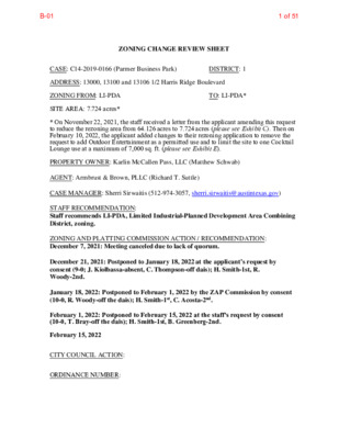
ZONING CHANGE REVIEW SHEET CASE: C14-2019-0166 (Parmer Business Park) DISTRICT: 1 ADDRESS: 13000, 13100 and 13106 1/2 Harris Ridge Boulevard ZONING FROM: LI-PDA TO: LI-PDA* SITE AREA: 7.724 acres* * On November 22, 2021, the staff received a letter from the applicant amending this request to reduce the rezoning area from 64.126 acres to 7.724 acres (please see Exhibit C). Then on February 10, 2022, the applicant added changes to their rezoning application to remove the request to add Outdoor Entertainment as a permitted use and to limit the site to one Cocktail Lounge use at a maximum of 7,000 sq. ft. (please see Exhibit E). PROPERTY OWNER: Karlin McCallen Pass, LLC (Matthew Schwab) AGENT: Armbrust & Brown, PLLC (Richard T. Suttle) CASE MANAGER: Sherri Sirwaitis (512-974-3057, sherri.sirwaitis@austintexas.gov) STAFF RECOMMENDATION: Staff recommends LI-PDA, Limited Industrial-Planned Development Area Combining District, zoning. ZONING AND PLATTING COMMISSION ACTION / RECOMMENDATION: December 7, 2021: Meeting canceled due to lack of quorum. December 21, 2021: Postponed to January 18, 2022 at the applicant’s request by consent (9-0; J. Kiolbassa-absent, C. Thompson-off dais); H. Smith-1st, R. Woody-2nd. January 18, 2022: Postponed to February 1, 2022 by the ZAP Commission by consent (10-0, R. Woody-off the dais); H. Smith-1st, C. Acosta-2nd. February 1, 2022: Postponed to February 15, 2022 at the staff's request by consent (10-0, T. Bray-off the dais); H. Smith-1st, B. Greenberg-2nd. February 15, 2022 CITY COUNCIL ACTION: ORDINANCE NUMBER: B-011 of 51 C14-2019-0166 ISSUES: N/A 2 CASE MANAGER COMMENTS: The site under consideration is a 7.724 acre parcel surrounding a water quality pond (known as Parmer Pond) that is part of a larger approximately 300 acre tract of land located at the southwest corner of two arterial roadways, East Howard Lane and Harris Ridge Boulevard. At the time of the original rezoning application in 2019, this property was undeveloped and sparsely vegetated. However, since that time a portion of the site has been developed as the Community Recreation- Private use (St. David's Performance Center and the Austin FC Youth Academy). In addition to these facilities, a project called "The Pitch" was also developed on the property that has restaurant and commercial uses in one and two-story container pods to provide services for the tenants and visitors of the adjacent soccer fields. The lots to the north of this larger LI-PDA zoned property, across E. Howard Lane, are also zoned LI- PDA and are developed with single-family residences. The tracts of land to south and east are zoned LI-PDA and LR-CO and are undeveloped. To the west, across Harris Ridge Boulevard, there is GR, LO-CO and SF-2 zoning transitioning away from E. Howard Lane to the south. There is a Service Station/Food Sales use (Chevron) located at the corner, a vacant tract of land, and single-family residences (Harris Ridge Owner’s Association). In this rezoning request, the applicant is asking for an amendment to the conditions the Planned Development Area (PDA) overlay for the property described as part of Lot 13, Parmer Business Park and Lot 14B, Parmer Business Park Amendment Plat of Lots 5, 6, 8A, and 14A to remove a condition in in Ordinance No. 20170518-056 that limits restaurant and cocktail lounge uses on the site. In addition, the applicant is requesting to amend the original PDA ordinances, Ordinance No. 980226-G and 980430-P, to add Cocktail Lounge as a permitted use in this portion of the PDA (Please see Applicant’s 2nd Amendment Request Letter- Exhibit E). The staff recommends the applicant’s request to amend the Planned Development Area overlay. The proposed PDA amendment will permit one up to 7,000 sq. ft. cocktail lounge use on this 7+ acre area on the LI-PDA property to allow for services to accompany the adjacent civic uses. The staff is recommending LI-PDA zoning for this site because of the commercial character of the area and because the property fronts onto and will take access to two major arterial roadways. The proposed zoning will permit the applicant to provide commercial services in an area with a variety of commercial and industrial employment centers along East Howard Lane. The applicant agrees with the staff’s recommendation. BASIS OF RECOMMENDATION: 1. The proposed zoning should be consistent with the purpose statement of the district sought. Limited industrial service (LI) district is the designation for a commercial service use or limited manufacturing use generally located on a moderately-sized site. The purpose of a planned development area (PDA) combining district is to: provide for industrial and commercial uses in certain commercial and industrial (1) base districts; or incorporate the terms of a planned development area agreement into a zoning (2) ordinance following annexation of a property that is subject to a planned development area agreement. B-012 of 51 C14-2019-0166 3 2. The proposed zoning should promote consistency and orderly planning. The proposed LI-PDA zoning will be compatible with surrounding land uses because this tract land is adjacent to undeveloped areas to the south and west. There is LI-PDA zoning to the west and to the north across E. Howard Lane. The original ordinance for this LI- PDA zoned property includes landscape buffers and building setbacks along Harris Ridge Boulevard between Howard Lane and Parmer Lane (Please see Ordinance No. 980226- G). These conditions provide for a separation between the uses within the PDA from the single-family residential developments to the east. 3. The proposed zoning should allow for a reasonable use of the property. The proposed amendment to the existing LI-PDA zoning will permit the applicant to provide for commercial services in an area with a variety of commercial and industrial employment centers along East Howard Lane. This PDA is located at the southwest intersection of two major arterial roadways, East Howard Lane and Harris Ridge Boulevard, and is near a designated neighborhood center, the Dessau/Parmer Neighborhood Center, which is to the east. The property is located between two activity corridors, the E. Howard Lane and Parmer Lane Activity Corridors, as identified in the Imagine Austin Comprehensive Plan. EXISTING ZONING AND LAND USES: ZONING Site North South East LI-PDA LI-PDA LI-PDA, LR-CO, SF-2 LI-PDA, SF-2 LAND USES Civic Uses, Commercial/Restaurant Uses Office, Soccer Fields Detention Pond, Undeveloped Area, Single Family Residences Soccer Fields, Single Family Residences (Harris Ridge Neighborhood) West LI-PDA Undeveloped NEIGHBORHOOD PLANNING AREA: N/A TIA: Not Required WATERSHED: Harris Branch SCHOOLS: Pflugerville I.S.D. Dessau Elementary School Delco Primary School Dessau Middle School Connally High School B-013 of 51 C14-2019-0166 4 NEIGHBORHOOD ORGANIZATIONS: Bike Austin Friends of Austin Neighborhoods Harris Glen Homeowners Association Harris Ridge Owner’s Association Harris Ridge Phase IV Homeless Neighborhood Association Neighborhood Empowerment Foundation North Growth Corridor Alliance Pflugerville Independent School District SELTEXAS Sierra Club, Austin Regional Group Tech Ridge Neighbors Yager Community AREA CASE HISTORIES: REQUEST LI-PDA to LI-PDA COMMISSION 3/07/17: Approved staff recommendation of LI-PDA zoning, with additional conditions for no outdoor amplified sound and to require a TIA at the time of Site Plan (10-0); B. Greenberg-1st, B. Evans-2nd. NUMBER C14-2016- 0124 (Parmer Business Park: Southwest Corner of East Howard Lane and Harris Ridge Boulevard) I-RR to LI C14-04-0139 (1100 East Howard Lane) 11/2/04: Approved staff’s recommendation of LI-CO zoning, with a 2,000 vtpd and adding a condition of no Adult Oriented Businesses, by consent (9-0); J. Martinez-1st, J. Gohil- 2nd. CITY COUNCIL 4/20/17: Approved the ZAP Commission’s recommendation for LI-PDA zoning on consent on 1st reading, with additional conditions that a multifamily use be limited to 900 residential dwelling units and that a TIA be conducted at the time of site plan review if a multifamily use is proposed to be built on the property (11-0); L. Pool-1st, G. Casar-2nd. 5/18/17: Ordinance No. 20170518- 056 was approved for limited industrial services-planned development area (LI-PDA) combining district zoning, to change a condition of zoning on Council Member Garza’s motion, Council Member Alter’s second on a 9-0 vote. Council Members Casar and Troxclair were off the dais. 12/02/04: Approved LI-CO (7-0); all 3 readings B-014 of 51 C14-04-0073 CS-CO to CS-1 7/20/04: Approved staff’s C14-00-2099 SF-2, GR to CS 10/17/00: Approved staff’s rec. C14-2019-0166 C14-04-0120 I-LI to LI C14-03-0069 SF-2 to CS C14-02-0111 Tract 1: GR- CO to GR Tract 2: CS-CO to CS C14-01-0169 IP to CS C14-98-0265 AV to LI C14-98-0212 I-RR to CS C14-96-0131 SF-2 to GR C14-93-0094 SF-2 to GR, CS-1 C14-93-0047 SF-2 to CS 9/7/04: Approved staff’s recommendation of LI-CO by consent (8-0, J. Martinez-absent) recommendation of CS-1 zoning by consent (8-0, J. Pinnelli- absent) 5/6/03: Approved CS-CO zoning with condition to prohibit Adult Oriented Businesses, by consent (8-0, K. Jackson-absent) 10/15/02: Approved staff’s recommendation of GR-CO; CS- CO zoning with added condition to prohibit Automotive Sales; by consent (7-0, D. Castaneda- absent) 2/5/02: Approved staff’s alternate rec. of CS-CO w/conditions by consent (8-0) of CS-CO, with no Adult Oriented Businesses (8-0) 5/25/99: Approved staff rec. of LI-PDA w/ condition regarding bicycle parking Approved GR-CO w/conditions for front to match existing GR and CS-CO for remainder of property, prohibit auto repair and auto washing except for on-site tenants (5-2, GW/DS-Nay) on 12/15/98 12/10/96: Approved staff rec. of GR (9-0) 5 10/21/04: Approved LI-CO zoning (7-0); all 3 readings 8/26/04: Approved CS-1 (7-0); all 3 readings 6/5/03: Granted CS-CO on all 3 readings (7-0) 12/5/02: Granted GR-CO for Tract 1 and CS-CO for Tract 2 on all 3 readings (7-0) 3/21/02: Approved CS-CO w/ other conditions (7-0); 1st reading 4/11/02: Approved CS-CO (6-0); 2nd/3rd readings 12/14/00: Approved CS-CO w/ additional prohibited uses (7-0); all 3 readings 6/3/03: Approved LI-PDA w/ conditions (7-0); all 3 readings-on emergency passage Approved PC rec. of GR-CO w/ conditions 97-0); 1st reading on 1/14/99 Approved CS-CO w/ conditions (7-0); 2nd/3rd readings on 4/15/99 1/9/97: Approved GR-CO w/ conditions (7-0); 1st reading 8/17/93: Approved CS-1-CO (TR1), GR-CO (TR2) w/ conditions (5-0) 4/27/93: Approved GR-CO (6-0) 5/6/93: Approved GR-CO & CS-CO 3/20/97: Approved GR-CO w/conditions (7-0); 2nd/3rd readings 11/3/94: Approved CS-1-CO & GR-CO (5-0); all 3 readings w/ conditions (6-0); 1st reading 6/17/93: Approved GR-CO (7-0); 2nd/3rd readings B-015 of 51 C14-2019-0166 RELATED CASES: 6 C14-2016-0124, C14-98-0032, C14-97-0141 (Previous Zoning Cases) C8-2015-0167.0A (Subdivision Case) EXISTING STREET CHARACTERISTICS: Name ROW Pavement Classification Sidewalks Bike Route Harris Ridge Boulevard Varies MAD-2 Major Arterial No E. Howard Lane 140’ MAD-4 Major Arterial Yes Yes Yes OTHER STAFF COMMENTS: Comprehensive Planning The subject tract for this zoning case is located near two Activity Corridors (East Howard Lane and East Parmer Lane) and near the Dessau/Parmer Neighborhood Center, which is to the east. The property is located on the west side of Harris Ridge Boulevard on a vacant parcel with a detention pond. The property is not located within the boundaries of a Neighborhood Plan Area. Surrounding land uses includes vacant land, an office/warehouse business park and a large single family subdivision to the north; to the south is large business park, a drugstore, a restaurant and several apartment complexes; to the east is a single family subdivision and Settler’s Ridge Park; and to the west is another large tech center/business park. The request is an amendment to the Planned Development Agreement from restaurant/cocktail lounge to a cocktail lounge and outdoor entertainment. Connectivity: A public sidewalk is located on the opposite side of Harris Ridge Boulevard. Bike lanes are located on both sides the street. There is a Cap Metro transit stops located approximately 1,800 linear feet, to the south of East Parmer Lane. Mobility options in the area are average while the connectivity options for the amount of development already in this area are fair. Imagine Austin The Imagine Austin Growth Concept Map, found in the Imagine Austin Comprehensive Plan (IACP), identifies this project as being near two Activity Corridors (E. Howard Lane and Parmer Lane). Page 106 of Imagine Austin states: “Activity Corridors have a dual nature. They are the connections that link activity centers and other key destinations to one another and allow people to travel throughout the city and region by bicycle, transit, or automobile. Activity Corridors are also characterized by a variety of activities and types of buildings located along the roadway — shopping, restaurants and cafés, parks, schools, single-family houses, apartments, public buildings, houses of worship, mixed-use buildings, and offices.” P. 106 This project is also located near the boundaries of a Neighborhood B-016 of 51 C14-2019-0166 7 Center, as identified on the Imagine Austin’s Growth Concept Map. Like many Imagine Austin Centers, this center is represented by a circle or globular shape that reflects the general location where the center should be located in the future. The center’s actual boundaries would need to be clarified through a small area planning process. Neighborhood Centers are defined as, “The smallest and least intense of the three mixed-use centers are neighborhood centers. As with the regional and town centers, neighborhood centers are walkable, bikeable, and supported by transit. The greatest density of people and activities in neighborhood centers will likely be concentrated on several blocks or around one or two intersections. However, depending on localized conditions, different neighborhood centers can be very different places. If a neighborhood center is designated on an existing commercial area, such as a shopping center or mall, it could represent redevelopment or the addition of housing. In other instances, new or redevelopment may occur incrementally and concentrate people and activities along several blocks or around one or two intersections. Neighborhood centers will be more locally focused than either a regional or a town center. Businesses and services— grocery and department stores, doctors and dentists, shops, branch libraries, dry cleaners, hair salons, schools, restaurants, and other small and local businesses—will generally serve the center and surrounding neighborhoods.” The following IACP policies are also relevant to this case: LUT P3. Promote development in compact centers, communities, or along corridors that are connected by roads and transit that are designed to encourage walking and bicycling, and reduce health care, housing and transportation costs. LUT P4. Protect neighborhood character by directing growth to areas of change that include designated redevelopment areas, corridors and infill sites. Recognize that different neighborhoods have different characteristics and new and infill development should be sensitive to the predominant character of these communities. LUT P7. Encourage infill and redevelopment opportunities that place residential, work, and retail land uses in proximity to each other to maximize walking, bicycling, and transit opportunities. HN P10. Create complete neighborhoods across Austin that have a mix of housing types and land uses, affordable housing and transportation options, and access to schools, retail, employment, community services, and parks and recreation options. Analysis and Conclusion This area of Austin has an abundance of residential uses and office parks but contains little in the way of walkable goods and services and a destination place for people living in this area. The Imagine Austin Growth Concept Map identifies this property being near a Neighborhood Center and two Activity Corridors, which supports a mix of neighborhood and regional serving goods and services. Based on the subject tract’s location, mobility strengths, the Imagine Austin policies above that supports complete communities, and providing neighborhood/regional serving goods and services, the proposed PDA amendment request supports Imagine Austin. B-017 of 51 C14-2019-0166 Environmental 8 The site is not located over the Edwards Aquifer Recharge Zone. The site is in the Harris Branch Watershed of the Colorado River Basin, which is classified as a Suburban Watershed by Chapter 25-8 of the City's Land Development Code. The site is in the Desired Development Zone. Under current watershed regulations, development or redevelopment on this site will be subject to the following impervious cover limits: % of Gross Site Area % of Gross Site Area with Transfers 50% 60% Development Classification Single-Family (minimum lot size 5750 sq. ft.) Other Single-Family or Duplex 55% 60% Multifamily 80% Commercial 60% 70% 90% According to floodplain maps there is a floodplain within or adjacent to the project location. Based upon the location of the floodplain, offsite drainage should be calculated to determine whether a Critical Water Quality Zone exists within the project location. Standard landscaping and tree protection will be required in accordance with LDC 25-2 and 25-8 for all development and/or redevelopment. At this time, site specific information is unavailable regarding vegetation, areas of steep slope, or other environmental features such as bluffs, springs, canyon rimrock, caves, sinkholes, and wetlands. Under current watershed regulations, development or redevelopment requires water quality control with increased capture volume and control of the 2-year storm on site. At this time, no information has been provided as to whether this property has any ls that preempt current water quality or Code requirements. Site Plan Site plans will be required for any new development other than single-family or duplex residential. Any development which occurs in an SF-6 or less restrictive zoning district which is located 540 feet or less from property in an SF-5 or more restrictive zoning district will be subject to compatibility development regulations. Any new development is subject to Subchapter E. Design Standards and Mixed Use. Additional comments will be made when the site plan is submitted. B-018 of 51 C14-2019-0166 9 Compatibility Standards The site is subject to compatibility standards. Along east property line, the following standards apply: • No structure may be built within 25 feet of the property line. • No structure in excess of two stories or 30 feet in height may be constructed • No structure in excess of three stories or 40 feet in height may be constructed within 50 feet of the property line. within 100 feet of the property line. • No parking or driveways are allowed within 25 feet of the property line. • A landscape area at least 25 feet wide is required along the property line. In addition, a fence, berm, or dense vegetation must be provided to screen adjoining properties from views of parking, mechanical equipment, storage, and refuse collection. • For a structure more than 100 feet but not more than 300 feet from property zoned SF-5 or more restrictive, height limitation is 40 feet plus one foot for each 10 feet of distance in excess of 100 feet from the property line. • An intensive recreational use, including a swimming pool, tennis court, ball court, or playground, may not be constructed 50 feet or less from adjoining SF- 3 property. • A landscape area at least 25 feet in width is required along the property line if the tract is zoned LR, GO, GR, L, CS, CS-1, or CH. Additional design regulations will be enforced at the time a site plan is submitted. FYI – There is a site plan currently under review on this property (SP-2019-0340D) proposing roadway construction associated water & wastewater improvements. Additional comments may be generated during the site plan review process. Transportation A Traffic Impact Analysis (TIA) was not required as it is waived per City Ordinance No. 980226-G for this site. Additional right-of-way maybe required at the time of subdivision and/or site plan. It is recommended that per LDC 25-6-101 (Ordinance No. 20170302-077), all subdivisions and site plans provide mitigation for traffic impacts with the zoning application. This should be included in the zoning ordinance. B-019 of 51 C14-2019-0166 10 The adjacent street characteristics table is provided below: Name ROW Pavement Classification Sidewalks Bicycle Facility Capital Metro (within ¼ mile) No ASMP Level 3 Yes Yes ASMP Level 3 No No No Howard lane 140’ Harris Ridge Blvd 90’ Austin Water Utility Multiple lanes with divided median Multiple lanes with divided median FYI: The landowner intends to serve the site with City of Austin water and wastewater utilities. The landowner, at own expense, will be responsible for providing any water and wastewater utility improvements, offsite main extensions, water or wastewater easements, utility relocations and or abandonments required by the proposed land use. Depending on the development plans submitted, water and or wastewater service extension requests may be required. Water and wastewater utility plans must be reviewed and approved by Austin Water for compliance with City criteria and suitability for operation and maintenance. All water and wastewater construction must be inspected by the City of Austin. The landowner must pay the City inspection fee with the utility construction. The landowner must pay the tap and impact fees once the landowner makes an application for Austin Water utility tap permits. INDEX OF EXHIBITS TO FOLLOW A: Zoning Map (Revised) B. Aerial Map (Revised) C. Applicant’s Amended Rezoning Request Letter D. Redlined PDA Zoning Ordinances E. Applicant's 2nd Amendment Request Letter, with Proposed Redlined Ordinance No. 980226-G B-0110 of 51 ! ! ! ! ! ! ! ! ! ! ! ! ! ! ! ! ! ! ! ! ! ! ! ! ! ! ! ! ! ! ! ! ! ! ! ! ! ! ! ! ! ! ! ! ! ! ! ! ! ! ! ! ! ! ! ! ! ! ! ! ! ! ! ! ! ! ! ! ! ! ! ! ! ! ! ! ! ! ! ! ! ! !! ! ! ! ! ! ! ! ! ! ! ! ! ! ! ! ! ! ! ! ! ! ! ! ! ! ! ! ! ! ! ! ! ! ! ! ! ! ! ! ! ! ! ! ! ! ! ! ! ! ! ! ! ! ! ! ! ! ! ! ! ! ! ! ! ! ! ! ! ! ! ! ! ! ! ! ! ! ! ! ! ! ! ! ! ! ! ! ! ! ! ! ! ! ! ! ! ! ! ! ! ! ! ! ! ! ! ! ! ! ! ! ! ! ! ! ! ! ! ! ! ! ! ! ! ! ! ! ! ! ! ! ! ! ! ! ! ! ! ! ! ! ! ! ! ! ! ! ! ! ! ! ! ! ! ! ! ! ! ! ! ! ! ! ! ! ! ! ! ! ! ! ! ! ! ! ! ! ! ! ! ! ! ! ! ! ! ! ! ! ! ! ! ! ! ! ! ! ! ! ! ! ! ! ! ! ! ! ! ! ! ! ! ! ! ! ! ! ! ! ! ! ! ! ! ! ! ! ! ! ! ! ! ! ! ! ! ! ! ! ! ! ! ! ! ! ! ! ! ! ! ! ! ! ! ! ! ! ! ! ! ! ! ! ! ! ! ! ! ! ! ! ! ! ! ! ! ! ! ! ! ! ! ! ! ! ! ! ! ! ! ! ! ! ! ! ! ! ! ! ! ! ! ! ! ! ! ! ! ! ! ! ! ! ! ! ! ! ! ! ! ! ! ! ! ! ! ! ! ! ! ! ! ! ! ! ! ! ! ! ! ! ! ! ! ! ! ! ! ! ! ! ! ! ! ! ! ! ! ! ! ! ! ! ! ! ! ! ! ! ! ! ! ! ! ! ! ! ! ! ! ! ! ! ! ! ! ! ! ! ! ! ! ! ! ! ! ! ! ! ! ! ! ! ! ! ! ! ! ! ! ! ! ! ! ! ! ! ! ! ! ! ! ! ! ! ! ! ! ! ! ! ! ! ! ! ! ! ! ! ! ! ! ! ! ! ! ! ! ! ! ! ! ! ! ! ! ! ! ! ! ! ! ! ! ! ! ! ! ! ! ! ! ! ! ! ! ! ! ! ! ! ! ! ! ! ! ! ! ! ! ! ! ! ! ! ! ! ! ! ! ! ! ! ! ! ! ! ! ! ! ! ! ! ! ! ! ! ! ! ! ! ! ! ! ! ! ! ! ! ! ! ! ! ! ! ! ! ! ! ! ! ! ! ! ! ! ! ! ! ! ! ! ! ! ! ! ! ! ! ! ! ! ! ! ! ! ! ! ! ! ! ! ! ! ! ! ! ! ! ! ! ! ! ! ! ! ! ! ! ! ! ! ! ! ! ! ! ! ! ! ! ! ! ! ! ! ! ! ! ! ! ! ! !! ! ! ! ! ! ! !! ! ! ! ! ! !! ! ! ! ! ! ! ! ! ! ! ! ! ! ! ! ! ! ! ! ! ! ! ! ! ! ! ! ! ! ! ! ! ! ! ! ! ! ! ! ! ! ! ! ! ! ! ! ! ! ! ! ! ! ! ! ! ! ! ! ! ! ! ! ! ! ! ! ! ! ! ! ! ! ! ! ! ! ! ! ! ! ! ! ! ! ! ! ! ! ! ! ! ! ! ! ! ! ! ! ! ! ! ! ! ! ! ! ! ! ! ! ! ! ! ! ! ! ! ! ! ! ! ! ! ! ! ! ! ! ! ! ! ! ! ! ! ! ! ! ! ! ! ! ! ! ! ! ! ! ! ! ! ! ! ! ! ! ! ! ! ! ! ! ! ! ! ! ! ! ! ! ! ! ! ! ! ! ! !! ! ! ! ! ! ! ! ! ! ! ! ! ! ! ! ! ! ! ! ! ! ! ! ! ! ! ! ! ! ! ! ! ! ! ! ! ! ! ! ! ! ! ! ! ! ! ! ! ! ! ! ! ! ! ! ! ! ! ! ! ! ! ! ! ! ! ! ! ! ! ! ! ! ! ! ! ! ! ! ! ! ! ! ! ! ! ! ! ! ! ! ! ! ! ! ! ! ! ! ! ! ! ! ! ! ! ! ! ! ! ! ! ! ! ! ! ! ! ! ! ! ! ! ! ! ! ! ! ! ! ! ! ! ! ! ! ! ! ! ! ! ! ! ! ! ! ! ! ! ! ! ! ! ! ! ! ! ! ! ! ! ! ! ! ! ! ! ! ! ! ! ! ! ! ! ! ! ! ! ! ! ! ! ! ! ! ! ! ! ! ! ! ! ! ! ! ! ! ! ! ! ! ! ! ! ! ! ! ! ! ! ! ! ! ! ! ! ! ! ! ! ! ! ! ! ! ! ! ! ! ! ! ! ! ! ! ! EXHIBIT A H E ! ! C12M-00-0005.09 ! ! ! !! O ! W A R ! E D L H ! N O LI-PDA W A ! R D L N ! ! ! ! ! ! ! ! ! ! ! C12M-00-0005.09 ! ! ! ! ! ! ! ! ! ! ! ! ! !! LI-PDA R E D G R RID E M R A P LI-PDA CENTER LAKE DR ! ! ! ! ! ! ! ! ! ! ! ! ! ! ! ! ! ! ! ! ! ! ! ! ! LI-PDA C14-97-0141 C14-97-0141 C14-2016-0124 ! ! ! ! ! ! ! ! ! ! ! ! ! ! ! ! ! ! ! ! ! ! ! ! ! ! ! ! ! ! ! ! ! ! ! ! ! ! ! ! ! ! ! ! ! ! ! ! ! ! ! ! ! ! ! ! ! ! ! 97-0141 SP- 04-0275C ! ! ! ! ! ! ! ! ! ! ! ! ! ! ! ! ! ! UNDEV ! ! ! ! ! ! ! ! ! ! ! ! ! ! ! ! ! !! ! ! ! ! ! ! ! ! ! ! ! ! ! ( ( ( ! ! ! ! ( ( ( ( ! ! ! ! ! ! H A R R I S R I D G E B L V D ! ! ! ! ! 2007-0087 C14-2016-0094 LR-CO C14-2007-0087 C14-95-0183(RCA) 95-0183 ( ( ( ( ( ( CASSAT CV ( ( ( UNDEV C14-2007-0087(RCA) C14-95-0183(RCA2) SP-2007-0360C GR-MU C14-2016-0094 99-0043 ! ! ! ! ! ! ! ! ! GR ! ! ! LO-CO ! ! ! ! ( ( ( ( ( SF-2 ( ( ( SF-2 ( ( C R E S T D R FAIR ( ( ( ( ( ( ( SF-2 ( ( ( ( HAVERFORD DR ( ( ( ( ( ( ( ( ( ( ( ! ! ! ! ! ! ( ( ! ! ! ! ! ! ! ! ! ( ( ( SF-2 ( ( ( ( ( ( BE N NIN G T O N LN ( ( ( ( ( B L U SF-2 E F O ( X D R ( ( ( ( ( ( ( ( ( ( ! ! ! ! ! ( ( ( ( ( ( ( ( ( H A T ( ( T E R A ( ( S D R ( ( ( ( ( ( ( ( ( ( ( ( ( ( B R IA ( ( R G A T E D R ( ( ( ( SF-2 ( ( ( ( DETENTION POND 94-0168 ( ( ( ( ( ( ( SF-2 ( ( ( ( ( ( ( ( ( ( ( ( ( ( SF-2 ( ( ( ( ( ( ( ( ( ( ( ( ( ( ( ( ( ( ( ( ( ( ( ( ( R E D AT G D L FIE ( SF-2 94-0168 ( JOSH RIDGE BLVD ( SF-2 ( ( ( ( ( ( ( ( ( ( 94-0168 ( ( ( ( ( ( ( ( ( ( ( ( ( ( H E Y E ( R D A H D I O ( SF-2 ( ( N Y S U ( S D R ( ( ( ( ( 94-0168 ( ( ( ( ( ( ( ( ( ( L D R ( ( SF-2 94-0168 ( ( ( ( ( 95-0183 MF-2-CO C14-99-0043 APARTMENTS SP-99-2069C ZONING ZONING CASE#: C14-2019-0166 E P A R M E R LN C14-98-0073 LI-PDA C14-96-0154 D LV E B G H RID C TE GR ± SUBJECT TRACT ! ! ! ! ! ! PENDING CASE ZONING BOUNDARY This product is for informational purposes and may not have been prepared for or be suitable for legal, engineering, or surveying purposes. It does not represent an on-the-ground survey and represents only the approximate relative location of property boundaries. 1 " = 400 ' This product has been produced by the Housing and Planning Department for the sole purpose of geographic reference. No warranty is made by the City of Austin regarding specific accuracy or Created: 4/23/2021 B-0111 of 51 EXHIBIT B 314B25A5362212127205323121242252434147131610262172910538413245A131416203513130281038442931161225723111921323130154591614156A3151733194268111528122473689286728B7118103116299C14-2019-0166LI-PDASF-2GR-MUMF-2-COSF-2SF-2SF-2LR-COSF-2SF-2LI-PDAHEYERDAHLDRBLUEFOX DRDIONYSUSDRBENNINGTON LNCASSATCVHATTERAS DRJOSHRIDGE BLVDBRIARGATE DRCENTER LAKE DRHARRISRIDGE BLVDHARRISRIDGE BLVDPERFORMANCE DRN34Copyright nearmap 2015±This map has been produced by the Communications Technology Management Dept. on behalf of thePlanning Development Review Dept. for the sole purpose of geographic reference. No warranty is madeby the City of Austin regarding specific accuracy or completeness.ZONING CASE#:LOCATION:SUBJECT AREA:GRID:MANAGER:C14-2019-016613106-1/2 Harris Ridge Blvd (SW corner of E Howard Ln & Harris Ridge Blvd)63.68 AcresN34SHERRI SIRWAITIS1'' = 300'CREEK BUFFERPENDING CASE!!!!!!ZONING BOUNDARYSUBJECT TRACTParmer Business ParkB-0112 of 51 EXHIBIT C B-0113 of 51 B-0114 of 51 EXHIBIT D ORDINANCE NO. 98Q43Q-P AN ORDINANCE REZONING AND CHANGING THE ZONING MAP ACCOMPANYING CHAPTER 13-2 OF THE CITY CODE ON APPROXIMATELY 450 ACRES OF LAND OUT OF THE ALEXANDER WALTERS SURVEY NO. 67, IN TRAVIS COUNTY, TEXAS, FROM "LI" LIMITED INDUSTRIAL DISTRICT AND "LI-PDA" LIMITED INDUSTRIAL SERVICES DISTRICT-PLANNED DEVELOPMENT AREA COMBINING DISTRICT DEVELOPMENT RESERVE DISTRICT TO "LI-PDA" LIMITED INDUSTRIAL SERVICES DISTRICT- PLANNED DEVELOPMENT AREA COMBINING DISTRICT, GENERALLY KNOWN AS THE DELL-PARMER NORTH DEVELOPMENT, LOCALLY KNOWN AS 301 EAST HOWARD LANE, IN THE CITY OF AUSTIN, TRAVIS COUNTY, TEXAS. BE IT ORDAINED BY THE CITY COUNCIL OF THE CITY OF AUSTIN: PART 1. The Zoning Map established by Chapter 13-2-22 of the City Code is amended to change the respective base zoning districts on the property (the "Property") described in File C14-98-0032, as follows: Tract 1: From "LI" Limited Industrial district to "LI-PDA" Limited Industrial Services district-Planned Development Area combining district. 150.576 acre tract of land out of the Thomas C. Collins Survey No. 61, Travis County, Texas, SAVE & EXCEPT a 0.099 acre parcel for R.O.W. recorded in Volume 12735, Page 1961, of the Real property Records of Travis County, Texas, the remaining 150.477 tract of land being more particularly described by metes and bounds in Exhibit "A" incorporated into this ordinance, Tract 2: From "LI-PDA" Limited Industrial Services district-Planned to "LI-PDA" Limited Industrial Development Area combining district Services district-Planned Development Area combining district. 32.485 acre tract of land out of the Alexander Walters Survey No. 67, Travis County, Texas, the tract of land being more particularly described by metes and bounds in Exhibit "B" incorporated into this ordinance #63 Page 1 of3 B-0115 of 51 Tract 3: From "LI-PDA" Limited Industrial Services district-Planned to "LI-PDA" Limited Industrial Development Area combining district Services district-Planned Development Area combining district. 33.342 acre tract of land out of the Alexander Walters Survey No. 67, Travis County, Texas, the tract of land being more particularly described by metes and bounds in Exhibit "C" incorporated into this ordinance, Tract 4: From "LI-PDA" Limited Industrial Services district-Planned Development Area combining district to "LI-PDA" Limited Industrial Services district-Planned Development Area combining district. 33.346 acre tract of land out of the Alexander Walters Survey No. 67, Travis County, Texas, the tract of land being more particularly described by metes and bounds in Exhibit "D" incorporated into this ordinance, Tract 5: From "LI-PDA" Limited Industrial Services district-Planned Development Area combining district to "LI-PDA" Limited Industrial Services district-Planned Development Area combining district. 56.495 acre tract of land out of the Alexander Walters Survey No. 67, Travis County, Texas, the tract of land being more particularly described by metes and bounds in Exhibit "E" incorporated into this ordinance, Tract 6: From "LI-PDA" Limited Industrial Services district-Planned to "LI-PDA" Limited Industrial Development Area combining district Services district-Planned Development Area 135.075 acre tract of land out of the Alexander Walters Survey No. 67 and the Menucan Hunt Survey No. 88, Travis County, Texas, the tract of land being more particularly described by metes and bounds in Exhibit "F" incorporated into this ordinance, Tract 7: From "LI-PDA" Limited Industrial Services district-Planned to "LI-PDA" Limited Industrial Development Area combining district Services district-Planned Development Area 10.721 acre tract of land out of the Alexander Walters Survey No. 67, Travis County, Texas, the tract of land being more particularly described by metes and bounds in Exhibit "G" incorporated into this ordinance, Page 2 of3 B-0116 of 51 generally known as the Dell-Parmer North Development, locally known as 301 East Howard Lane, in the City of Austin, Travis County, Texas, and as more particularly identified in the map attached as Exhibit "H". PART 2. The Property within the boundaries of the Planned Development Area combining district established by this ordinance shall conform to the site development standards as set forth in the "Site Development Standards" attached as Exhibit "I" to this ordinance. Except as specifically restricted under this ordinance, the Property may be developed and used in accordance with the regulations established for the "LI" Limited Industrial Services base district and other applicable requirements of the Land Development Code. PART 3. The Council waives the requirements of Sections 2-2-3, 2-2-5, and 2-2-7 of the City Code for this ordinance. PART 4. This ordinance takes effect on May 11, 1998. PASSED AND APPROVED 30 1998. Kirk Watson Mayor APPROVED: ATTEST: Andrew Martin City Attorney (J James E. Aldridge City Clerk Page 3 of 3 B-0117 of 51 'Ar-izoo SUBJECT TRACT PENDING CASE W7/////A • • • • • ZONING BOUNDARY CASE MGR: D.WAHLGF EN CASE #: C14- ADDRESS: 301 E.HC SUBJECT AREA (ac ZONING DATE: 98-03 Tl INTLS: / TRC OTY GRID REFERENCE NUMBER M34.M35 B-0118 of 51 SITE DEVELOPMENT STANDARDS Section 1. Applicable Site Development Regulations Development on the Property shall comply with applicable City of Austin regulations as of November 14, 1997, except as modified herein. Development on the Property will occur over time through the submission of multiple site plans. Section 2. Authorized Uses A. All "LI" Limited Industrial uses are permitted on the Property, except as set forth in Subsection B and C of this section. The following are additional permitted uses: Crop Production Animal Production B. The following uses are prohibited as principal and accessory uses of the Property: Automotive Sales Campground Exterminating Services Funeral Services Kennels Monument Retail Sales Stone Yards and Grain Elevators Railroad Facilities (except Terminals and Light Rail) Residential Treatment Veterinary Services Club or Lodge Congregate Living Transitional Housing Resource Extraction C. The following uses are prohibited principal uses of the Property, but are permitted as accessory uses to office, light manufacturing, assembly, and warehousing and distribution principal uses: 2/26/98 dellstds.2nd B-0119 of 51 Agricultural Sales and Services Automotive Rentals Automotive Repair Services Automotive Washing (of any type) Art & Craft Studio (Limited, General & Industrial) Construction Sales & Services Convenience Storage Equipment Repair Services Equipment Sales General Warehousing & Distribution Laundry Services Basic Industry Outdoor Entertainment Scrap & Salvage Recycling Center Counseling Services Maintenance & Service Facilities Indoor Entertainment Vehicle Storage Section 3. Site Development Regulations A. Performance Standards Development of the Property shall conform with all applicable provisions of the PDA Planned Development Area performance standards established by Section 13-2-269 of the Land Development Code. B. Base District Regulations Development of the Property shall conform to the site development regulations authorized for the "IP" Industrial Park district as set forth in the Land Development Code, except as provided for in this ordinance. Calculations for zoning impervious cover, building coverage, and floor-to-area ratios shall be based on the gross site area of the entire Property. 3) A site within the Property may extend across a public street or right-of-way. C. Buffers and Setbacks A 50-foot landscaped buffer zone shall be provided and maintained along the northern boundary of the Property adjacent to the Howard Lane/Dessau Road right-of-way in the area between Harris Ridge Boulevard and the western boundary of the residential lots west of Greinert Drive. An 80-foot landscaped buffer zone shall be provided and maintained along the property line adjacent to Harris Ridge Boulevard from Josh Ridge Boulevard to 1) 2) 1) 2) 2/26/98 dellstds.2nd B-0120 of 51 Howard Lane/Dessau Road. The buffer zone shall contain a four to six foot high undulating berm and a minimum of three shade trees and four ornamental trees trees per 100 linear feet along the Harris Ridge right-of-way. Construction of the berm shall begin prior to or concurrent with the construction of any building or parking lot within the area between Harris Ridge Boulevard and the existing row of trees located approximately 300 feet to 600 feet west of Harris Ridge Boulevard. Construction of the berm shall be diligently continued to completion. Improvements permitted within the buffer zone shall be limited to fences, drainage, sidewalks, utility improvements and improvements that may be required by the City of Austin or that are specifically authorized by the site development regulations for the Property. A 200-foot building setback shall be maintained from the existing right-of-way line of Harris Ridge Boulevard and between Howard Lane/Dessau Road and Farmer Lane. Improvements permitted within the setback shall be limited to fences, parking, driveways, landscaping, drainage, sidewalks, utility improvements and improvements that may be required by the City of Austin or that are specifically authorized by the site development regulations for the Property. A 300-foot setback, inclusive of the 200-foot building setback established in Subsection C(3) of this section, shall be maintained along Harris Ridge Boulevard from Parmer Lane to Howard Lane/Dessau Road. No structure shall be built to a height greater than 37 feet within the area. Utility improvements may be constructed within the setback. All distances shall be measured from the right-of-way lines that existed on November 14,1997, or that are shown on the preliminary plan for Harris Ridge (City of Austin File No. C8-84-0150). 3) 4) 5) Section 4. Landscaping A. Street Yard Requirements Street yard requirement calculations shall be based on the gross site area of the entire Property. Alternative compliance for truck staging areas shall be allowed. 2/26/98 dellstds.2nd 9 £0 s o >p B-0121 of 51 B. Tree Protection The owner of the Property is not required to replace a tree that is less than 19 inches in diameter after the tree is removed. The owner of the Property is required to replace each tree that is 19 inches or greater in diameter inch for inch, after the tree is removed. A surveyed tree that is eight inches or greater in diameter that is permanently preserved within the Property shall be counted toward the replacement of a tree that is 19 inches or greater in diameter that is removed. Section 5. Transportation A. Traffic Impact Analysis B. Access. C. Off-Street Parking No traffic impact analysis shall be required in connection with any zoning, subdivision, site development permit, or other city permit or approval with respect to the Property. No off-site traffic improvements shall be required in connection with any development. There shall be no curb cuts for vehicular access from the Property to Harris Ridge Boulevard between Josh Ridge Boulevard and Howard Lane. All vehicular access to the Property shall be from other adjacent public streets or through other portions of the Property. 1) 2) 3) 4) Off-street parking may be provided at any location on the Property, regardless of proximity to a particular building. There shall be at least one off-street parking space per 300 square feet of office or administrative activity space designed for human occupancy. There shall be at least one off-street parking space per 1,000 square feet of indoor manufacturing space designed for human occupancy. There shall be at least one off-street loading space per 140,000 square feet of occupied office, administrative, and indoor manufacturing space. For manufacturing and related support and test/sort areas, the number of square feet in the unoccupied mechanical, electrical, machine, air return and interstitial, 2/26/98 dellstds.2nd B-0122 of 51 utility, service and similar spaces shall not be included in determining parking and loading space computations. Accessory uses, including kitchen, cafeteria, dining, auditorium and similar spaces, recreational facilities, and day-care center and other similar facilities, shall not be included in the areas used to determine the required parking and loading space computations. Bicycle parking may be provided as deemed appropriate by the owner of the Property. 5) 6) Section 6. Water Quality A. B. The Director of the Watershed Protection Utility ("Director") or its successor department may grant a variance to authorize up to 20 feet of cut and fill to construct parking areas, driveways, temporary spoil sites, buildings, and loading docks between buildings. The Director may grant a variance to authorize up to 12 feet of cut and fill to construct a landscape berm. The provisions of Section 13-2-506 of the City Code apply to the variances requested under this section. Existing stock ponds with wetland characteristics located on the Property may be removed if mitigation is provided. Mitigation may occur within on-site or off-site wet pond water quality controls within the same drainage area or an equivalent mitigation strategy approved by the Director may be used. Section 7. Master Plan The owner of the Property shall track zoning impervious cover, building coverage, floor to area ratios, street yard compliance and off-street parking as development occurs on the Property. Current data on the standards shall be provided with each site plan that is submitted to the City for approval. Section 8. Amendments to City Code If the City Code is amended to authorize the director of a City department to administratively approve an amendment to or variance of any matters contained herein, the Owner of the Property shall be entitled to obtain an amendment or variance through the administrative process and shall not be required to seek Planning Commission or City Council approval of the amendment or variance. 2/26/98 dellstds.2nd B-0123 of 51 ORDINANCE NO. 20170518-056 AN ORDINANCE AMENDING ORDINANCE NO. 980226-G TO REZONE AND CHANGE THE ZONING MAP FROM LIMITED INDUSTRIAL SERVICES- PLANNED DEVELOPMENT AREA (LI-PDA) COMBINING DISTRICT TO LIMITED INDUSTRIAL SERVICES-PLANNED DEVELOPMENT AREA (LI- PDA) COMBINING DISTRICT FOR PROPERTY LOCATED AT THE SOUTHWEST CORNER OF EAST HOWARD LANE AND HARRIS RIDGE BOULEVARD. BE IT ORDAINED BY THE CITY COUNCIL OF THE CITY OF AUSTIN: PART 1. The planned development area is comprised of property originally known as the Dell-Parmer North Development planned development area ("Dell-Parmer North Development PDA"). On February 26, 1998, the Dell-Parmer North Development PDA was approved under Ordinance No. 980226-G. This ordinance affects a portion of the property identified in the Dell Parmer North Development PDA as described in Part 2 below and shown on the attached Exhibit "A". PART 2. The zoning map established by Section 25-2-191 of the City Code is amended to change the base district from limited industrial services-planned development area (LI- PDA) combining district to limited industrial services-planned development area (LI-PDA) combining district on the property described in Zoning Case No. CI4-2016-0124, on file at the Planning and Zoning Department, as follows: Lots 6 and 14, Parmer Business Park Subdivision, a subdivision in the City of Austin, Travis County, Texas, as more particulariy described in Document No. 201600107 recorded in the Official Public Records of Travis County, Texas (the "Property"), locally known as the southwest corner of East Howard Lane and Harris Ridge Boulevard in the City of Austin, Travis County, Texas, and generally identified in the map attached as Exhibit "A". PART 3. Development of the Property is subject to the limitations and conditions set forth below. A. A multifamily residential use is permitted on the Property. Any multifamily residential use on the Property shall be limited to 900 residential units and Page I of 2 B-0124 of 51 developed according to multifamily residence medium density (MF-3) base district site development standards. B. Development of the Property may include no more than one restaurant or one cocktail lounge use. If a restaurant is constructed on the Property, it may be a restaurant (general) or restaurant (limited) use. If a cocktail lounge is constructed on the Property, the cocktail lounge use is limited to a maximum of 6,000 square feet. C. A 175-foot wide building setback shall be established and maintained on the Property between industrial and multifamily residential uses and from the property line of any adjacent property with an industrial use. D. For multifamily residential use on the Property, a site plan or building permit for the Property may not be approved, released, or issued until a Traffic Impact Analysis (TIA) is submitted to and approved by the Director of the Development Services Department. PART 4. Except as otherwise provided in this ordinance, the terms and conditions of Ordinance No. 980226-G, as amended, remain in effect. PART 5. This ordinance takes effect on May 29, 2017. PASSED AND APPROVED May 18 2017 ayor APPROVED: ATTE Anne L. Morgan City Attorney Jannette S. Goodall City Clerk Page 2 of 2 B-0125 of 51 014-98-1 OFFICE/WAREHOUSE / -V "^.O T E C H V ^ ^ D G ' E " 3 L V D' GR*X "'X UNDEV G R^ N Subject Tract I ' "^ Pending Case L _ J Zoning Boundary Railroads Feet 0 200 400 600 1 " = 600 ' ZONING Case#: C14-2016-0124 EXHIBIT A This product Is for informational purposes and may not have tieen prepared tor or be suitable for legal, engineering, or surveying purposes. It does not represent an an-the.ground survey and represents only the approiimate relative location ol property boundaries. This product has been produced by Ihe Planning and Zoning Department for the sole purpose of geographic reference. No warranty is made by the City ol Austin regarding specific accuracy or completeness. Created: 3/22/2017 B-0126 of 51 EXHIBIT E B-0127 of 51 ORDINANCE NO. 98Q43Q-P AN ORDINANCE REZONING AND CHANGING THE ZONING MAP ACCOMPANYING CHAPTER 13-2 OF THE CITY CODE ON APPROXIMATELY 450 ACRES OF LAND OUT OF THE ALEXANDER WALTERS SURVEY NO. 67, IN TRAVIS COUNTY, TEXAS, FROM "LI" LIMITED INDUSTRIAL DISTRICT AND "LI-PDA" LIMITED INDUSTRIAL SERVICES DISTRICT-PLANNED DEVELOPMENT AREA COMBINING DISTRICT DEVELOPMENT RESERVE DISTRICT TO "LI-PDA" LIMITED INDUSTRIAL SERVICES DISTRICT- PLANNED DEVELOPMENT AREA COMBINING DISTRICT, GENERALLY KNOWN AS THE DELL-PARMER NORTH DEVELOPMENT, LOCALLY KNOWN AS 301 EAST HOWARD LANE, IN THE CITY OF AUSTIN, TRAVIS COUNTY, TEXAS. BE IT ORDAINED BY THE CITY COUNCIL OF THE CITY OF AUSTIN: PART 1. The Zoning Map established by Chapter 13-2-22 of the City Code is amended to change the respective base zoning districts on the property (the "Property") described in File C14-98-0032, as follows: Tract 1: From "LI" Limited Industrial district to "LI-PDA" Limited Industrial Services district-Planned Development Area combining district. 150.576 acre tract of land out of the Thomas C. Collins Survey No. 61, Travis County, Texas, SAVE & EXCEPT a 0.099 acre parcel for R.O.W. recorded in Volume 12735, Page 1961, of the Real property Records of Travis County, Texas, the remaining 150.477 tract of land being more particularly described by metes and bounds in Exhibit "A" incorporated into this ordinance, Tract 2: From "LI-PDA" Limited Industrial Services district-Planned to "LI-PDA" Limited Industrial Development Area combining district Services district-Planned Development Area combining district. 32.485 acre tract of land out of the Alexander Walters Survey No. 67, Travis County, Texas, the tract of land being more particularly described by metes and bounds in Exhibit "B" incorporated into this ordinance #63 Page 1 of3 B-0128 of 51 Tract 3: From "LI-PDA" Limited Industrial Services district-Planned to "LI-PDA" Limited Industrial Development Area combining district Services district-Planned Development Area combining district. 33.342 acre tract of land out of the Alexander Walters Survey No. 67, Travis County, Texas, the tract of land being more particularly described by metes and bounds in Exhibit "C" incorporated into this ordinance, Tract 4: From "LI-PDA" Limited Industrial Services district-Planned Development Area combining district to "LI-PDA" Limited Industrial Services district-Planned Development Area combining district. 33.346 acre tract of land out of the Alexander Walters Survey No. 67, Travis County, Texas, the tract of land being more particularly described by metes and bounds in Exhibit "D" incorporated into this ordinance, Tract 5: From "LI-PDA" Limited Industrial Services district-Planned Development Area combining district to "LI-PDA" Limited Industrial Services district-Planned Development Area combining district. 56.495 acre tract of land out of the Alexander Walters Survey No. 67, Travis County, Texas, the tract of land being more particularly described by metes and bounds in Exhibit "E" incorporated into this ordinance, Tract 6: From "LI-PDA" Limited Industrial Services district-Planned to "LI-PDA" Limited Industrial Development Area combining district Services district-Planned Development Area 135.075 acre tract of land out of the Alexander Walters Survey No. 67 and the Menucan Hunt Survey No. 88, Travis County, Texas, the tract of land being more particularly described by metes and bounds in Exhibit "F" incorporated into this ordinance, Tract 7: From "LI-PDA" Limited Industrial Services district-Planned to "LI-PDA" Limited Industrial Development Area combining district Services district-Planned Development Area 10.721 acre tract of land out of the Alexander Walters Survey No. 67, Travis County, Texas, the tract of land being more particularly described by metes and bounds in Exhibit "G" incorporated into this ordinance, Page 2 of3 B-0129 of 51 generally known as the Dell-Parmer North Development, locally known as 301 East Howard Lane, in the City of Austin, Travis County, Texas, and as more particularly identified in the map attached as Exhibit "H". PART 2. The Property within the boundaries of the Planned Development Area combining district established by this ordinance shall conform to the site development standards as set forth in the "Site Development Standards" attached as Exhibit "I" to this ordinance. Except as specifically restricted under this ordinance, the Property may be developed and used in accordance with the regulations established for the "LI" Limited Industrial Services base district and other applicable requirements of the Land Development Code. PART 3. The Council waives the requirements of Sections 2-2-3, 2-2-5, and 2-2-7 of the City Code for this ordinance. PART 4. This ordinance takes effect on May 11, 1998. PASSED AND APPROVED 30 1998. Kirk Watson Mayor APPROVED: ATTEST: Andrew Martin City Attorney (J James E. Aldridge City Clerk Page 3 of 3 B-0130 of 51 IFIELDNOTE DESCRIPTION land out of the Thomas C. Collins Survey No. BEING a 150.576 acre tract of that certain 267.278 acre 61 in Travis County, Texas and being a portion of in V o l. 7779, page 388 Deed Records of said county,SAVE & tract described in EXCEPT Volume 12735, Page 1961 of the Real Property Records of Travis County, Texas, a remaining 150.477 acre tract being more particularly described by metes and bounds as follows: for R . O . W. Acquisition recorded that 0.099 Acre parcel of land inch iron rod found the South Right-of-Way line of BEGINNING at a 1/2 in Volume 10247, Page West Dessau Road according to a Street Deed recorded for street widening), 296 R.P.R.T.C.T. (1.66 acre tract a 1/2 the Northeast corner inch iron rod was found for of said 267.278 acre tract and situated N 30° 03' 36" E, a distance of 66.50 feet; to City of Austin reference marking in THENCE departing said Right-of-Way line, along or near the East line of said Thomas C. Collins Survey and the West line of the Alexander Walters Survey and the general line of a barbed wire fence, the following two (2) calls: South 30° 03' 36" West, a distance of 2,598.25 feet iron rod found for corner at a fence intersection for angle point; to a 1/2 inch South 29° 56* 55" West, a distance of 2,129.86 feet to a 1/2 inch iron rod (with TxD.O.T. Aluminum cap ) the curving North Right-of-Way line of Parmer Lane (Farm-Market Road I 734 - 200' wide) as set forth in a Community Facilities contract between the City of Austin and Airpark Associates dated Sept. 20, \% inch iron pipe was(previously) 1984 and from said iron rod a found reference marking the Southeast corner of said 267.278 acre tract bearing S 29° 56' 55" W, a distance of 33.95 feet; found for corner for in THENCE along the said North Right-of-Way line of Parmer Lane the Three (3) calls: following along a circular curve to the left having a radius of 2,009.86 feet through a central angle of 09° 53' 30", an arc length of 346.98 feet, a chord bearing North 83° 25' 39" West a chord distance of 346.55 feet to a 1/2 inch iron rod (with TxD.O.T. aluminum cap) found for the Point of Tangency to said curve; ( with TxD.O.T. aluminum cap) found North 88° 25' 30" West, a distance of 27.31 feet rod a non-tangent, circular curve to feet; inch iron to a 1/2 for a Point of curvature of the left having a radius of 2,496.19 along said circular curve to the left, Chord bearing North 85° 16' 14" for West, a chord distance of 83.14 feet the Southeast corner of a 2.256 acre L . C . R . A. tract as described in Vol. 9790, Page 985 R.P.R.T.C.T.-, to a 1/2 inch iron rod found "substation" THENCE departing said North R.O.W. line of proposed Parmer Lane, along East (4) calls: then North line of said 2.256 acre L.C.R.A. tract the the following four B-0131 of 51 150.477 acres continued North 48° 39' 08" East, a distance of 14.06 feet iron rod found for angle point; to a 1/2 inch North 3° 43' 45" East, a distance of 94.09 feet to a 1/2 inch iron rod found for angle point; North 42° 41' 03" West, a distance of 14.07 feet iron rod found for angle point; to a 1/2 inch North 86° 13' 44" West, a distance of 328.93 feet iron rod found for corner; to a 1/2 inch THENCE departing the North line of said L.C.R.A. tract, across the said 267.278 acre tract the following three (3) calls: North 2° 50' 25" East, a distance of 82.63 feet to a 1/2 inch iron rod found in the Airport's emergency sand pit; South 87° 08' 52" East, a distance of 299.61 feet iron rod in concrete found for corner; to a 1/2 inch North 11° 11' 43" East, a distance of 5,122.29 feet to a 1/2 inch iron rod in concrete found for corner in the said South Right-of-Way line of West Dessau Road; THENCE along Road the following five (5) calls: the aforementioned new South Right-of-Way line of West Dessau Along a circular curve to the right having a central angle of 4° 43' 00", a radius of 1,456.64 feet, an arc length of 119.91 feet, a chord bearing of South 57° 07' 57" East, a chord distance of 119.88 feet to a 1/2 inch iron rod found for a point of tangency; South 54° 43' 18" East, a distance of 305.59 feet iron rod found for the right having a radius of 1,456.64 feet; inch the point of curvature of a circular curve to to a 1/2 Along said circular curve through a central angle of 4° 43' 03", an arc length of 119.95 feet, a chord bearing of South 57° 05' 18" East a chord distance of 119.90 feet to a 1/2 inch iron rod found for the point of tangency; the right to South 59° 27' 05" East, a distance of 1,255.22 feet to a 1/2 inch iron rod Set for a point of curvature of a circular curve to the right having a radius of 1,678.67 feet; Along said circular curve to through a central angle of 13° 20' 42", an arc length of 390.99 feet, a chord bearing of South 52° 46' 55" East, a chord distance of 390.10 feet the POINT OF BEGINNING and containing an area of 150.477 Acres of land. the right to B-0132 of 51 32.485 ACRES MARTHA LUCILLE McADAMS VERTREES TRACT 2- FN NO. 97-398 (MM) SEPTEMBER 18, 1997 BPI JOB NO. 725-05.92 DESCRIPTION OF A 32.485 ACRE TRACT OR PARCEL OF LAND OUT OF AND A PART OF THE ALEXANDER WALTERS SURVEY NO. 67, SITUATED IN TRAVIS COUNTY, TEXAS, BEING ALL OF THAT CERTAIN 32.48 ACRE TRACT CONVEYED TO MARTHA LUCILE McADAMS VERTREES BY DEED OF RECORD IN VOLUME 6424, PAGE 325 OF THE DEED RECORDS OF TRAVIS COUNTY, TEXAS; SAID 32.485 ACRES BEING MORE PARTICULARLY DESCRIBED BY METES AND BOUNDS AS FOLLOWS: BEGINNING, at a 1/2 inch iron rod found at the northwesterly corner of that certain 149.591 acre tract known as Parcel 3 conveyed to Ridge Investors Limited by deed of record in Volume 12038, Page 1581 of the Real Property Records of Travis County, Texas, being in the easterly line of that certain 150.477 acre tract conveyed to Northpoint Business Park (Austin) PIP, L.'P. by deed of record in Volume 12735, Page 1954 of said Real Property Records, same being the southwesterly corner of said 32.48 acre tract; THENCE, N29°43'18"E, along the easterly line of said 150.477 acre tract, being the westerly lir.e of said 32.48 acre tract, a distance of 2772.01 feet to a 1/2 inch iron rod found in the curving southerly right-of-way line of Dessau Road (R.O.W. varies), being the northeasterly corner of said 150.477 acre tract, same being the northwesterly corner of said 32.48 acre tract; THENCE, along the southerly line of Dessau Road, being the northerly line of said 32.48 are tract the following two (2) courses and distances: 1) 2) Along a non-tangent curve to the right, having a radius of 636.46 feet, a central angle of 11°34'13", an arc distance of 128.53 feet, and a chord which bears S39°08'07"E, a distance of 128.31 feet to a 1/2 ir.ch iron rod found at the point of tangency; S34°39'56"E, a distance of 458.51 feet to a 1/2 inch iron rod found at the northwesterly corner of that certain 33.34 acre tract of land conveyed to Martha Lucile McAdams Vertrees, et. al. by deed of record in Volume 8495, Page 747 of said Deed Records, being the northeasterly corner of said 32.48 acre tract, from which a 1/2 inch iron rod found in the northerly line of said 33.34 are tract bears S34°39'56"E, a distance of 427.84 feet; THENCE, S29°43'02"W, leaving the southerly line of Dessau Road, along the westerly line of said 33.34 acre tract, being the easterly line of said 32.48 acre tract, a distance of 2525.92 feet to a 1/2 inch iron rod found in the northerly line-of said Parcel 3, being the southeasterly corner of said 32-48 acre tract; B-0133 of 51 FN 97-398 (MM) SEPTEMBER 18, 1997 PAGE 2 OF 2 THENCE, N60°27'00"W, along the northerly line of said Parcel 3, being the southerly line of said 32.48 acre tract, a distance of 533.33 feet to the POIKT OF BEGINNING, containing an area of 32.485 acres (1,415,062 sq. ft.) of land, more or less, within these metes and bounds. I, JOHN T. BILNOSKI, A REGISTERED PROFESSIONAL LAND SURVEYOR, DO HEREBY CERTIFY THAT THE PROPERTY DESCRIBED HEREIN WAS DETERMINED BY A SURVEY MADE ON THE GROUND UNDER MY DIRECTION AND SUPERVISION. A LAND TITLE SURVEY WAS PREPARED TO ACCOMPANY THIS FIELDNOTE DESCRIPTION. BURY & PITTMAN, INC. ENGINEERS-SURVEYORS 3345 BEE CAVE ROAD SUITE 200 AUSTIN, TEXAS 78746 JOHN/?. BILNOSKI, R.P.L.S NO. 4998 STATE OF TEXAS DATE B-0134 of 51 3 DESCRIPTION 33.342 ACRES - TRACT 3 MARTHA LUCILE McADAMS VERTREES, ET. AL. FN NO. 97-399 (MM) SEPTEMBER 18, 1997 BPI JOB NO. 725-05.92 OF A 33.342 ACRE TRACT OR PARCEL OF LAND OUT OF AND A PART OF THE ALEXANDER WALTERS SURVEY NO. 67, SITUATED IN TRAVIS COUNTY, TEXAS, BEING ALL OF THAT CERTAIN 33.34 ACRE TRACT CONVEYED TO MARTHA LDCILE McADAMS VERTREES, ET. AL. BY DEED OF RECORD IN VOLUME 8495, PAGE 747 OF THE DEED RECORDS OF TRAVIS COUNTY, TEXAS; SAID 33.342 ACRES BEING MORE PARTICULARLY DESCRIBED BY METES AND BOUNDS AS FOLLOWS: BEGINNING, at a 1/2 inch iron rod found in the northerly line of that certain tract of land called Parcel 3 conveyed to Ridge Investors Limited by deed of record in Volume 12038, Page 1581 of the Real Property Records of Travis County, Texas, being the southeasterly corner of that certain 32.48 acre tract conveyed to Martha Lucile McAdams Vertrees by deed of record in Volume 6424, Page 325 of said Deed Records, same being the southwesterly corner of said 33.34 acre tract, from which a 1/2 inch iron rod found in the easterly line of that certain 150.477 acre tract conveyed to Northpoint Business Park (Austin) PIP, L.P. by deed of record in Volume 12735, Page 1954 of said Real Property Records, same being the northwesterly corner of said Parcel 3, and also being the southwesterly corner of said 32.48 acre tract bears, N60°27'00"W, a distance of 533.33 feet; THENCE, N29°43'02//E, along the easterly line of said 32.48 acre tract, being the westerly line of said 33.34 acre tract, a distance of 2525.92 feet to a 1/2 inch iron rod found in the southerly right-of-way line of Dessau Road (R.O.W. varies) , being the northeasterly corner of said 32.48 acre tract, same being the northwesterly corner of said 33.34 acre tract; THENCE, along the southerly line of Dessau Road, being the northerly line of said 33.34 acre tract, the following Two (2) courses and distances: 1) S34°39'56"E, a distance of 427.84 feet to a 1/2 inch iron rod found at the point of curvature of a non-tangent curve to the left; 2) Along said non-tangent curve to the left, having a radius of 1088.37 feet, a central angle of 12°31'02", an arc distance of 237.77 feet and a chord which bears S40°53'32"E, a distance of 237.30 feet to a 1/2 inch iron rod found at the northwesterly corner of that certain tract of land conveyed to MuecJce-McAdams Texas, Ltd. by deed of record in Volume 12963, Page 243 of said Real Property Records, being the northeasterly corner of said 33.34 acre tract; 3D-P- B-0135 of 51 FN 97-398 (MM) SEPTEMBER 18, 1997 PAGE 2 OF 2 THENCE, S29°42'54"W, leaving the southerly line of Dessau Road, along the westerly line of said Muecke-McAdams Texas, Ltd. Tract, being the easterly line of said 33.34 acre tract, a distance of 2259.27 feet to a 1/2 inch iron rod found in the northerly line of said Parcel 3, being the southwesterly corner of said Muecke- McAdams Texas, Ltd. tract, same being the southeasterly corner of said 33.34 acre tract; THENCE, along the northerly line of said Parcel 3, being the southerly line of said 33.34 acre tract, the following two (2) courses and distances: 1) N60°49'23"W, a distance of 171.55 feet to a 1 inch iron pipe found for an angle point; 2) N60°27'00"W, a distance of 438.17 feet to the POINT OF BEGINNING containing an area of 33.342 acres (1,452,390 sq. ft.) of land, more or less within these metes and bounds. I, JOHN T. BILNOSKI, A REGISTERED PROFESSIONAL LAND SURVEYOR, DO HEREBY CERTIFY THAT THE PROPERTY DESCRIBED HEREIN WAS DETERMINED BY A SURVEY MADE ON THE GROUND UNDER MY DIRECTION AND SUPERVISION. A LAND TITLE SURVEY WAS PREPARED TO ACCOMPANY THIS FIELDNOTE DESCRIPTION. BURY & PITTMAN, INC. ENGINEERS-SURVEYORS 3345 BEE CAVE ROAD SUITE 200 AUSTIN, TEXAS 78746 JOHN NO. 4^98 STATE OF TEXAS DATE B-0136 of 51 33.346 ACRES MUECXE-McADAMS TEXAS, LTD. FN NO. 97-400 (MM) SEPTEMBER 18, 1997 BPI JOB NO. 725-05.92 DESC3LI2TION OF A 33.346 ACRE TRACT OR PARCEL OF LAND OUT OF AND A PART OF THE ALEXANDER WALTERS SURVEY NO. 67, SITUATED IN TRAVIS COUNTY, TEXAS, BEING ALL OF THAT CERTAIN 33.34 ACRE TRACT CONVEYED TO MUECKE- McADAMS TEXAS, LTD. BY DEED OF RECORD IN VOLUME 12963, PAGE 243 OF THE REAL PROPERTY RECORDS Cr TRAVIS COUNTY, TEXAS; SAID 33.346 ACRES BEING MORE PARTICULARLY DESCRIBED BY METES AND BOUNDS AS FOLLOWS: BEGINNING, at a 1/2 inch iron, red found in the northerly line of that certain tract of land called Parcel 3 conveyed to Ridge Investors Limited by deed of record in Volume 12038, Page 1581 of said Real Property Records, being the southeasterly corner of that certain tract of land conveyed to Martha Lucile McAdams Vertrees, Et. Al. by deed of record ir. Vclume 8495, Page 747 of the Deed Records of Travis County, Texas, sane being the southwesterly corner of said 33.34 acre tract; THENCE, N29°42'54/'E/ along tr.s easterly line of said McAdams Vertrees tract, being the westerly line of said 33,34 acre tract, a distance of 2259.27 feet tc a 1/2 inch iron rod found in the curving southerly right-of-way line of Dessau Road (R.O.W. varies), being the northeasterly corner of said McAdams Vertrees tract, same being the northwesterly corner of said 33.34 acre tract; THENCE, along the southerly line of Dessau Road, being the northerly line of saici 33.34 acre tract, the following two (2) courses and distances: 1) Along a non-tangent curve co the left, having a radius of 1088.37 feet, a central ar.cle of 12°52'54", an arc distance of 244.70 feet and a chord which bears S53"35'3Q"E, a distance of 244.13 feet to a 1/2 inch iron rod set at the point of tangency of said curve; 2) S60aOO'57"E, a distance cf 4:3.30 feet to a 1/2 inch iron rod found at the northwesterly corner of that certain 56.51 acre tract conveyed to McAda.T.s Properties, Ltd. by deed of record in Volume 12335, Page 136 cf said Real Property Records, being the northeasterly corner of said 33.34 acre tract; THENCE, S29343'23"W, leaving the southerly line of Dessau Road, along the westerly line of said 55.51 acre tract, being the easterly line of said 33.34 acre tract, a distance of 2222.77 feet to a 1/2 inch iron rod found ir. the northerly line of said Parcel 3, being the southwesterly corner of said 56.51 acre tract, being the southeasterly corner cf said 33.34 acre tract; same •P B-0137 of 51 FN 97-400 (MM) SEPTEMBER 18, 1997 PAGE 2 OF 2 THZNCS, N60a49'23"W, along the r.criherly line of said Parcel 3, being the southerly line of said 33.34 acre tract, a distance of 651.03 feet to the POINT 0? BEGINNING, containing an area of 33.346 acres (1,452,554 sc. f~.) of land, more or less, within these metes and bounds. I, JOHN T. BILNOSKI, A REGISTERED PROFESSIONAL LAND SURVEYOR, DO HEREBY CERTIFY THAT THE PROPERTY DESCRIBED HEREIN WAS DETERMINED BY A SURVEY MADE ON THE GROUND UNDER MY DIRECTION AND SUPERVISION. A LAND TITLE SURVEY WAS PREPAID TO ACCOMPANY THIS FIELDNOTE DESCRIPTION. BURY & PITTMAN, INC. ENGINEERS-SURVEYORS 3345 BEE CAVE ROAD SUITE 200 AUSTIN, TEXAS 78746 JCHNvT. BILNOSKI, R.P.L.S. NO. ^998 ST.-.7E OF TEXAS DATS B-0138 of 51 56.495 ACRES McADAMS PROPERTIES, LTD. TRACT 5 FN NO. 97-401 (MM) SEPTEMBER 18, 1997 BPI JOB NO. 725-05.92 DESCRIPTION OF A 56.495 ACRE TRACT OR PARCEL OF LAND OUT OF AND A PART OF THE ALEXANDER WALTERS SURVEY NO. 67, SITUATED IN TRAVIS COUNTY, TEXAS, BEING ALL OF THAT CERTAIN 56.51 ACRE TRACT CONVEYED TO McADAMS PROPERTIES, LTD. BY DEED OF RECORD IN VOLUME 12335, PAGE 136 OF THE REAL PROPERTY RECORDS OF TRAVIS COUNTY, TEXAS; SAID 56.495 ACRES BEING MORE PARTICULARLY DESCRIBED BY METES AND BOUNDS AS FOLLOWS : BEGINNING, at a 1/2 inch iron rod found in the northerly line of that certain tract of land called Parcel 3 conveyed to Ridge Investors Limited by deed of record in Volume 12038, Page 1581 of the Real Property Records of Travis County, Texas, being the southeasterly corner of that certain 33.34 acre tract conveyed to Muecke-McAdams Texas/ Ltd. by deed of record in Volume 12963, Page 243 of said Real Property Records, same being the southwesterly corner of said 56.51 acre tract; THENCE, N29°43'23"E, along the easterly line of said 33.34 acre tract, being the westerly line of said 56.51 acre tract, a distance of 2222 .77 feet to a 1/2 inch iron rod found in the southerly line of Dessau Road (R.O.W. varies) , being the northeasterly corner of said 33.34 acre tract, same being the northwesterly corner of said 56 . 51 acre tract; THENCE, along the southerly line of Dessau Road, being the northerly line of said 56.51 acre tract the following two (2) courses and distances: 1) S60Q00'57"E, a distance of 786.24 feet to a 1/2 inch iron rod found at the point of curvature of a non- tangent curve to the right; 2) Along said non-tangent curve to the right, having a radius of 424.98 feet, a central angle of 25°56'57", an arc distance of 192.47 feet and a chord which bears S47°45'47"E, a distance of 190 .83 feet to a 1/2 inch iron rod found at the most northwesterly corner of that certain tract of land called Parcel 4 conveyed to Ridgs Investors Limited by deed of record in Volume 12038, Page 1581 of said Real Property Records, same being the northeasterly corner of said 56.51 acre tract; B-0139 of 51 FN 97-401 (MM) SEPTEMBER 18, 1997 PAGE 2 OF 2 THENCE, S22°14'40"W, leaving the southerly line of Dessau Road, along the westerly line of said Parcel 4, being the easterly line of said 56.51 acre tract, a distance of 2184.44 feet to a 1/2 inch iron rod set, being an angle point in the westerly line of that certain tract of land called Parcel 2, Tract 2 conveyed to Ridge Investors Limited by deed of record in Volume 12038, Page 1581, of said Real Property Records, being the northeasterly corner of said Parcel 3, same being the most southwesterly corner of said Parcel 4, same being the southeasterly corner of said 56.51 acre tract ; THENCE, N60°49'23"W, along the northerly line of said Parcel 3, being the southerly line of said 56.51 acre tract, a distance of 1256.91 feet to the POINT OF BEGINNING, containing an area of 56.495 acres (2,460,942 sq. ft.) of land, more or less, within these metes and bounds. I, JOHN T. BILNOSKI, A REGISTERED PROFESSIONAL LAND SURVEYOR, DO HEREBY CERTIFY THAT THE PROPERTY DESCRIBED HEREIN WAS DETERMINED BY A SURVEY MADE ON THE GROUND UNDER MY DIRECTION AND SUPERVISION. A LAND TITLE SURVEY WAS PREPARED TO ACCOMPANY THIS FIELDNOTE DESCRIPTION. BURY & PITTMAN, INC. ENGINEERS-SURVEYORS 3345 BEE CAVE ROAD SUITE 200 AUSTIN, TEXAS 78746 JOHM/T. BILNOSKI, R.P.L.S NO. 4998 STATE OF TEXAS DATE B-0140 of 51 A DESCRIPTION OF 135.075 ACRES OF LAND OUT OF THE ALEXANDER WALTERS SURVEY NO. 67 AND THE MENUCAN HUNT SURVEY NO. 88 IN TRAVIS COUNTY, TEXAS, SAID 135,075 ACRES BEING ALL OF THAT CERTAIN 23.099 ACRE TRACT (CALLED PARCEL 4), AND ALL OF THAT CERTAIN 1.537 ACRE TRACT (CALLED PARCEL 2, TRACT 2), A 108.952 ACRE PORTION OF THAT CERTAIN 149.591 ACRE TRACT OF LAND (CALLED PARCEL 3) AS CONVEYED TO RIDGE INVESTORS LIMITED BY DEED RECORDED IN VOLUME 12038, PAGE 1581 OF THE REAL PROPERTY RECORDS OF TRAVIS COUNTY, TEXAS AND THAT CERTAIN 1.181 ACRE TRACT AND 0.306 ACRE TRACT CONVEYED TO RIDGE INVESTORS LIMITED BY DEED RECORDED IN VOLUME 13059, PAGE 0386 OF THE REAL PROPERTY RECORDS OF TRAVIS COUNTY, TEXAS; SAID 135.075 ACRES BEING MORE PARTICULARLY DESCRIBED BY METES AND BOUNDS AS FOLLOWS: BEGINNING at a 1/2-inch iron rod found for the northwest corner of the original 149.591 acre tract, same being the southwest corner of that certain 32.48 acre tract conveyed to Martha Lucile HcAdams by deed recorded in Volume 6424, Page 325 of the Deed Records of Travis County, Texas, same also being in the west line of that certain 150.576 acre tract conveyed to Harris Ridge Joint Venture by deed recorded in Volume 11811, Page 1447 of the Real Property Records of Travis County, Texas; THENCE with the north line of the herein described tract and the south line of the said 32.48 acre tract, S60°36/14IIE, a distance of 533.25 feet to a 1/2-inch iron rod found at the southeast corner of the said 32.48 acre tract, same being the southwest corner of that certain 33.34 acre tract of land referred to as "Tract 1" as recorded in Volume 8495, Page 747 o f the Deed Records of Travis County, Texas; THENCE continuing with the north line of the herein described tract and the south line of the said "Tract 1", the following two (2) calls: 1. S60q46'44"E, 378.17 feet to a 3/4-inch iron pipe found, 2. S60"30'26HE, 231.57 feet to a 1/2-inch iron rod found for the southeast corner of the said "Tract 1", same being the southwest corner of that certain 33.34 acre tract of land conveyed to Huebert O. Mueke, et al by deed recorded in said Volume 12592, Page 1279 of the Real Property Records of Travis County, Texas; THENCE continuing along the north line of the herein described tract, and the south line of said 33.34 acre tract the following two (2) calls: 1. S60°29'57"E, 454.32 feet to a 1/2-inch galvanized iron pipe found, and 2. S62°00'18"E, 196.78 feet to a 1/2-inch iron rod found at the southeast corner of the said 33.34 acre tract, same being the southwest corner of that certain 56.51 acre tract of land referred to as "Tract 3" as recorded in said Volume 8495, Page 747 of the Deed Records of Travis County, Tejxas; THENCE continuing with the north line of the herein described tract and the south line of the said "Tract 3" the following two (2) calls: B-0141 of 51 S60-32'43"E, 613.29 feel iron pipe found, and fo a 1 and 1/2-inch galvanized 2. S6l"22'17"E, 643.92 feet to a 1/2-inch iron rod found for the southeast corner of the said "Tract 3", same being on the west line of Krause Lane as vacated on November 25, 1986, by order of the Travis County Commissioner's Court, Cause 11313. THENCE along the common line between said 56.51 acre tract and that certain 1.73 acre vacated portion of Krause Lane, N22005'48"E,'2,184.37 feet to a 1/2-inch rod found in the aforementioned curving south line of Dessau Road (ROW Varies); THENCE along said south line of Dessau Road the following five (5) courses: 1. a distance of 127.47 feet along the arc of said curve to the right having a central angle of 17°45'35", a radius of 411.25 feet and a chord which bears S25*13'4tJ"E, 126.96 feet to a 1/2-inch iron rod found for the end of said curve; 2. S 15°55'22" E a distance of 496.08 feet to a point 3. S 22°06'14" E a distance of 86.19 feet to a point for 4. S 39°37'17" E a distance of 40.77 feet to a point for for corner; corner; corner; 5. S 59"55'15" E a distance of 172.63 feet to a point for corner in the west line of Harris Ridge Boulevard (90' ROW); THENCE with the west line of Harris Ridge Boulevard the following eight (8) courses: 1. S 28°57'54" W a distance of 24.37 feet to a 1/2-inch iron rod found for the beginning of a curve; 2. a distance of 20.53 feet along the arc of a curve to the right having a central angle of 06°10'35", a radius of 190.43 feet and a chord which bears S3l"l4'44"W, 20.52 feet to a 1/2-inch iron rod found for the point of tangency of said curve; 3. S29"14'32"W, 68.83 feet to a 1/2-inch iron rod found for the point of curvature of a curve to the left; 4. a distance of 69.04 feet along the arc of a curve to the left having a central angle of 06*07'57", a radius of 645.00 feet and a chord which bears S26"41'05"W, 69.00 feet to a 1/2-inch iron rod found for the end of said curve; 5. S23*31'12"W, 141.43 feet to a 1/2-inch iron rod found for the point of curvature of a curve to the right; 6. a distance of 59.46 feet along the arc of a curve to the right having a central angle of 06*G8'17H, a radius of 555.00 feet and a chord which bears S26*35'50"W, 59,43 feet to a 1/2-inch iron rod found for the end_of_aayid_^ P B-0142 of 51 7.' S29 42/53llw a distance "of 730.37 feet to a 1/2-inch iron rod found for the point of curvature of a curve to the right; 8. a distance of 1,026.76 feet along the arc of a curve to the right having a central angle of 43°23'38", a radius of 1355.00 feet and a chord which bears S51°26'13"W, 1,002.39 feet to a 1/2-inch iron rod set for the point of tangency said curve; 8. S 73*06'13" W a distance of 271.53 feet to northwest terminus point of existing Harris Ridge Boulevard; THENCE southwesterly with the proposed extension of said Harris Ridge Boulevard the following two (2) courses: 1. S 73°06'13" W a distance of 356.44 feet to the point of curvature of a curve to the left; 2. a distance of 619.85 feet along the arc of a curve to the left having a central angle of 30°04'56", a radius of 1180.59 feet and a chord which bears S58°03'57"W a distance of 612.75 feet to a 1/2-inch iron rod set for the end of said curve; THENCE N59*48'56"W, 817.95 feet to a 1/2-inch iron rod set for corner; THENCE S29*43'06"W/ 596.00 feet to a 1/2-inch iron rod set for corner in the existing north line of Farmer Lane (200' ROW) ; THENCE westerly along said north line of Farmer Lane the following two (2) courses: 1. N60°01'59"W, 953.86 feet to a Texas Department of Transportation aluminum cap in concrete found for the point of curvature of a curve to the left; 2. 659.99 feet along the arc of a curve to the left having a central angle of 18°48'52", a radius of 2,009.86 feet and a chord bearing N69°23'13"W/ 657.02 feet to a 1/2- inch iron rod set for corner in the common line between the aforementioned 149.591 acre tract and 150.576 acre tract; THENCE N29°31'10"E, along said common line a distance of 2,022.56 feet to the POINT OF BEGINNING of the herein described tract and containing 135.075 acres of land. I HEREBY CERTIFY THAT THIS METES AND BOUNDS DESCRIPTION WAS PREPARED FROM AN ACTUAL SURVEY PERFORMED ONTHE GROUND UNDER MY SUPERVISION AND IS TRUE AND CORRECT TJirfOT^aEST OF MY KNOWLEDGE. STEVEN R. McANGUS, R.P/LJS. NO. 3680 (The bearings shown hefcsan are referenced to Harris Ridge Phase I, Sectipn II recorded in Vol. 86, Pg. 125A of the Plat Records of Travis County, Texas.) - P B-0143 of 51 10.721 ACRES LOT 3, BLOCK "A" FARMER NORTH SECTION TWO FN NO. 98-057(MJJ) FEBRUARY 23, 1998 BPI JOB NO. 725-03.00 DESCRIPTION OF 10.721 ACRES OF LAND OUT OF THE ALEXANDER WALTERS SURVEY NO. 67 SITUATED IN TRAVIS COUNTY, TEXAS, BEING A PORTION OF THAT 149.591 ACRE TRACT OF LAND CALLED PARCEL 3 CONVEYED TO RIDGE INVESTORS BY DEED OF RECORD IN VOLUME 12038, PAGE 1581 OF THE REAL PROPERTY RECORDS OF TRAVIS COUNTY, TEXAS; SAID 10,721 ACRES BEING MORE PARTICULARLY DESCRIBED BY METES AND BOUNDS AS FOLLOWS: BEGINNING at a concrete monument found at the point of curvature (Highway Centerline Station 56+38.92, 100' Left) in the northerly line of Farmer Lane (200' R.O.W.) , being the southerly line hereof, from which a concrete monument found in the southerly line of Farmer Lane bears S30°07'48"W, a distance of 200.01 feet; THENCE, N59°53'06"W, along the northerly line of Farmer Lane, being the southerly line hereof, a distance of 676.57 feet to a 1/2 inch iron rod set with aluminum cap for the southwesterly corner hereof, from which a 1/2 inch iron rod found bears N12°55' 40"E, a distance of 3.10 feet and also from which a concrete monument found in the northerly line of Farmer Lane at the point of tangency of a curve to the right (Highway Centerline Station 40+08-49, 100' Left) bears N59°53'06"W, a distance of 953.86 feet; THENCE, leaving the northerly line of Farmer Lane, over and across said 149.591 acres, the following five (5) courses and distances: 1) 2) 3} N29°46'26"E, a distance of 596.09 feet to a 1/2 inch iron rod set with aluminum cap for the northwesterly corner hereof from which a 1/2 inch iron rod found bears N04°39' 12"W, a distance of 3.66 feet; S59°39'53"E, a distance of 817.95 feet to a 1/2 inch iron rod set with aluminum cap for the point of curvature of a non- tangent curve to the right and the northeasterly corner hereof from which a 1/2 inch iron rod found bears N43°01'36"E, a distance of 4.59 feet; Along said non-tangent curve to the right having a radius of 1180,59 feet, a central angle of 10°29'33", an arc length of 216.20 feet and a chord which bears S37°54'45"W, a distance of 215.90 feet to a 1/2 inch iron rod set with aluminum cap for the end of said curve; 4) S32°39'58"W, a distance of 356.63 feet to a 1/2 inch iron rod set with aluminum cap for the point of curvature of a curve to the right; B-0144 of 51 FN 98-057 (MJJ) February 23, 1998 Page 2 of 2 5) Along said curve to the right having a radius of 25.00 feet, a central angle of 89°21'15", an arc length of 38.99 and a chord which bears S77°20'37"W, a distance of 35.16 feet to a 1/2 inch iron rod set with aluminum cap in the curving northerly line of Farmer Lane for the southeasterly corner hereof; THENCE, along the curving northerly line of Partner Lane, along a curve to the left having a radius of 2009.86 feet, a central angle of 01°54'22//, an arc length of 66.86 feet and a chord which bears N58°55'55"W, a distance of 66.86 feet to the POINT OF BEGINNING containing an area of 10.721 acres (467,002 sq. ft.) of land more or less, within these metes and bounds. I, JOHN T. BILNOSKI, A REGISTERED PROFESSIONAL LAND SURVEYOR, DO HEREBY STATE THAT THIS DESCRIPTION IS BASED UPON BY A SURVEY PERFORMED ON THE GROUND UNDER MY DIRECTION AND SUPERVISION. BUR.Y & PITTMAN, INC. ENGINEERS-SURVEYORS 3345 BEE CAVE ROAD SUITE 200 AUSTIN, TEXAS 78746 JOHN T/. BILNOSKI R.P.L/S. NO. 4998 STATE OF TEXAS DATE B-0145 of 51 'Ar-izoo SUBJECT TRACT PENDING CASE W7/////A • • • • • ZONING BOUNDARY CASE MGR: D.WAHLGF EN CASE #: C14- ADDRESS: 301 E.HC SUBJECT AREA (ac ZONING DATE: 98-03 Tl INTLS: / TRC OTY GRID REFERENCE NUMBER M34.M35 B-0146 of 51 SITE DEVELOPMENT STANDARDS Section 1. Applicable Site Development Regulations Development on the Property shall comply with applicable City of Austin regulations as of November 14, 1997, except as modified herein. Development on the Property will occur over time through the submission of multiple site plans. Section 2. Authorized Uses A. All "LI" Limited Industrial uses are permitted on the Property, except as set forth in Subsection B and C of this section. The following are additional permitted uses: Crop Production Animal Production B. The following uses are prohibited as principal and accessory uses of the Property: Automotive Sales Campground Exterminating Services Funeral Services Kennels Monument Retail Sales Stone Yards and Grain Elevators Railroad Facilities (except Terminals and Light Rail) Residential Treatment Veterinary Services Club or Lodge Congregate Living Transitional Housing Resource Extraction C. The following uses are prohibited principal uses of the Property, but are permitted as accessory uses to office, light manufacturing, assembly, and warehousing and distribution principal uses: 2/26/98 dellstds.2nd B-0147 of 51 Agricultural Sales and Services Automotive Rentals Automotive Repair Services Automotive Washing (of any type) Art & Craft Studio (Limited, General & Industrial) Construction Sales & Services Convenience Storage Equipment Repair Services Equipment Sales General Warehousing & Distribution Laundry Services Basic Industry Outdoor Entertainment Scrap & Salvage Recycling Center Counseling Services Maintenance & Service Facilities Indoor Entertainment Vehicle Storage Section 3. Site Development Regulations A. Performance Standards Development of the Property shall conform with all applicable provisions of the PDA Planned Development Area performance standards established by Section 13-2-269 of the Land Development Code. B. Base District Regulations Development of the Property shall conform to the site development regulations authorized for the "IP" Industrial Park district as set forth in the Land Development Code, except as provided for in this ordinance. Calculations for zoning impervious cover, building coverage, and floor-to-area ratios shall be based on the gross site area of the entire Property. 3) A site within the Property may extend across a public street or right-of-way. C. Buffers and Setbacks A 50-foot landscaped buffer zone shall be provided and maintained along the northern boundary of the Property adjacent to the Howard Lane/Dessau Road right-of-way in the area between Harris Ridge Boulevard and the western boundary of the residential lots west of Greinert Drive. An 80-foot landscaped buffer zone shall be provided and maintained along the property line adjacent to Harris Ridge Boulevard from Josh Ridge Boulevard to 1) 2) 1) 2) 2/26/98 dellstds.2nd B-0148 of 51 Howard Lane/Dessau Road. The buffer zone shall contain a four to six foot high undulating berm and a minimum of three shade trees and four ornamental trees trees per 100 linear feet along the Harris Ridge right-of-way. Construction of the berm shall begin prior to or concurrent with the construction of any building or parking lot within the area between Harris Ridge Boulevard and the existing row of trees located approximately 300 feet to 600 feet west of Harris Ridge Boulevard. Construction of the berm shall be diligently continued to completion. Improvements permitted within the buffer zone shall be limited to fences, drainage, sidewalks, utility improvements and improvements that may be required by the City of Austin or that are specifically authorized by the site development regulations for the Property. A 200-foot building setback shall be maintained from the existing right-of-way line of Harris Ridge Boulevard and between Howard Lane/Dessau Road and Farmer Lane. Improvements permitted within the setback shall be limited to fences, parking, driveways, landscaping, drainage, sidewalks, utility improvements and improvements that may be required by the City of Austin or that are specifically authorized by the site development regulations for the Property. A 300-foot setback, inclusive of the 200-foot building setback established in Subsection C(3) of this section, shall be maintained along Harris Ridge Boulevard from Parmer Lane to Howard Lane/Dessau Road. No structure shall be built to a height greater than 37 feet within the area. Utility improvements may be constructed within the setback. All distances shall be measured from the right-of-way lines that existed on November 14,1997, or that are shown on the preliminary plan for Harris Ridge (City of Austin File No. C8-84-0150). 3) 4) 5) Section 4. Landscaping A. Street Yard Requirements Street yard requirement calculations shall be based on the gross site area of the entire Property. Alternative compliance for truck staging areas shall be allowed. 2/26/98 dellstds.2nd 9 £0 s o >p B-0149 of 51 B. Tree Protection The owner of the Property is not required to replace a tree that is less than 19 inches in diameter after the tree is removed. The owner of the Property is required to replace each tree that is 19 inches or greater in diameter inch for inch, after the tree is removed. A surveyed tree that is eight inches or greater in diameter that is permanently preserved within the Property shall be counted toward the replacement of a tree that is 19 inches or greater in diameter that is removed. Section 5. Transportation A. Traffic Impact Analysis B. Access. C. Off-Street Parking No traffic impact analysis shall be required in connection with any zoning, subdivision, site development permit, or other city permit or approval with respect to the Property. No off-site traffic improvements shall be required in connection with any development. There shall be no curb cuts for vehicular access from the Property to Harris Ridge Boulevard between Josh Ridge Boulevard and Howard Lane. All vehicular access to the Property shall be from other adjacent public streets or through other portions of the Property. 1) 2) 3) 4) Off-street parking may be provided at any location on the Property, regardless of proximity to a particular building. There shall be at least one off-street parking space per 300 square feet of office or administrative activity space designed for human occupancy. There shall be at least one off-street parking space per 1,000 square feet of indoor manufacturing space designed for human occupancy. There shall be at least one off-street loading space per 140,000 square feet of occupied office, administrative, and indoor manufacturing space. For manufacturing and related support and test/sort areas, the number of square feet in the unoccupied mechanical, electrical, machine, air return and interstitial, 2/26/98 dellstds.2nd B-0150 of 51 utility, service and similar spaces shall not be included in determining parking and loading space computations. Accessory uses, including kitchen, cafeteria, dining, auditorium and similar spaces, recreational facilities, and day-care center and other similar facilities, shall not be included in the areas used to determine the required parking and loading space computations. Bicycle parking may be provided as deemed appropriate by the owner of the Property. 5) 6) Section 6. Water Quality A. B. The Director of the Watershed Protection Utility ("Director") or its successor department may grant a variance to authorize up to 20 feet of cut and fill to construct parking areas, driveways, temporary spoil sites, buildings, and loading docks between buildings. The Director may grant a variance to authorize up to 12 feet of cut and fill to construct a landscape berm. The provisions of Section 13-2-506 of the City Code apply to the variances requested under this section. Existing stock ponds with wetland characteristics located on the Property may be removed if mitigation is provided. Mitigation may occur within on-site or off-site wet pond water quality controls within the same drainage area or an equivalent mitigation strategy approved by the Director may be used. Section 7. Master Plan The owner of the Property shall track zoning impervious cover, building coverage, floor to area ratios, street yard compliance and off-street parking as development occurs on the Property. Current data on the standards shall be provided with each site plan that is submitted to the City for approval. Section 8. Amendments to City Code If the City Code is amended to authorize the director of a City department to administratively approve an amendment to or variance of any matters contained herein, the Owner of the Property shall be entitled to obtain an amendment or variance through the administrative process and shall not be required to seek Planning Commission or City Council approval of the amendment or variance. 2/26/98 dellstds.2nd B-0151 of 51