B-11 (C8-2021-0090.0A - Maxwell Subdivision; District 3).pdf — original pdf
Backup
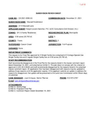
SUBDIVISION REVIEW SHEET CASE NO.: C8-2021-0090.0A COMMISSION DATE: December 21, 2021 SUBDIVISION NAME: Maxwell Subdivision ADDRESS: 2114 Maxwell Lane APPLICANT/AGENT: Sergio Lozano-Sanchez, P.E. (LOC Consultants Civil Division, Inc.) ZONING: SF-3 (Family Residence) NEIGHBORHOOD PLAN: Montopolis AREA: 0.59 acres (25,700 sf) LOTS: 5 COUNTY: Travis DISTRICT: 3 WATERSHED: Carson Creek JURISDICTION: Full Purpose VARIANCE: None DEPARTMENT COMMENTS: STAFF RECOMMENDATION: The request is for Final Plat approval for 5 Single Family lots comprised of 3 Cottage Special Use Single Family lots and 2 regular Single Family lots on 0.50 acres (25,700 sf). Staff recommends disapproval of the Final Plat for the reasons listed in the master comment report dated December 16, 2021, and attached as Exhibit C. The plat does not comply with the criteria for approval in LDC 25-4-84(B) and staff recommends disapproval for the reasons listed in the attached master comment report. An application that has been disapproved with reasons may be updated to address those reasons until the application expires. If the applicant submits an update to address the reasons for disapproval, that update will be presented to the Land Use Commission within fifteen days of submittal. CASE MANAGER: Juan Enriquez, Senior Planner PHONE: 512-974-2767 E-mail: juan.enriquez@austintexas.gov ATTACHMENTS Exhibit A: Vicinity Map Exhibit B: Proposed Final Plat Exhibit C: Comment Report Dated December 16, 2021 1 of 10 2 of 10 TRAVIS COUNTY CONSUMER PROTECTION NOTICE TO HOME BUYERS: IF YOU ARE BUYING A LOT IN THIS SUBDIVISION, YOU SHOULD DETERMINE WHETHER THE SUBDIVISION AND THE LAND AROUND IT ARE INSIDE OR OUTSIDE THE CITY LIMITS. THIS CAN AFFECT THE ENJOYMENT AND VALUE OF YOUR HOME. DEPENDING ON STATE LAW AND OTHER FACTORS, LAND OUTSIDE THE CITY LIMITS MAY BE SUBJECT TO FEWER LOCAL GOVERNMENT CONTROLS OVER THE DEVELOPMENT AND USE OF LAND THAN INSIDE THE CITY LIMITS. THE SUBDIVISION'S RESTRICTIVE COVENANTS MAY CREATE PRIVATELY ENFORCEABLE RESTRICTIONS INCOMPATIBLE LAND USES WITHIN THE AGAINST SUBDIVISION, WHETHER IT IS INSIDE OR OUTSIDE THE CITY LIMITS. DEPENDING ON STATE LAW AND OTHER FACTORS, HOWEVER, OUTSIDE THE CITY LIMITS NEITHER PRIVATE NOR GOVERNMENTAL RESTRICTIONS MAY BE AVAILABLE TO (1) RESTRICT EITHER THE NATURE OR EXTENT OF DEVELOPMENT NEAR THE SUBDIVISION, OR (2) PROHIBIT LAND USES NEAR THE SUBDIVISION THAT ARE INCOMPATIBLE WITH A RESIDENTIAL NEIGHBORHOOD. 3 of 10 9.2 0' 0.40' 0.60' LOT 1 JESSE TORRES SUBDIVISION BOOK 56, PAGE 27 T.C.P.R. (EASTERLY 130') S64°36'39"E 130.10' LOT 5 5,872.45 SF=0.13 ACRES C A L IN A S C U L A T O T E N D P E C OIN O L U T M N SNF 6801 E RIVERSIDE LLC 4.5906 ACRES 2019048013 T.C.P.R. N33°41'58"E 36.15' RAINAGE EASEMENT N33°41'58"E 67.92' N33°41'58"E 30.00' D LOT 3 THRASHER-CHAPA SUB AMENDED PLAT GILBERT & DORIS VELASQUEZ LOT 1 THRASHER-CHAPA SUB AMENDED PLAT GILBERT & DORIS VELASQUEZ 9.2 0' N33°41'58"E 30.00' N33°41'58"E 199.87' (N36°40'E 200') N33°41'58"E 30.00' N 6 4°4 4'2 4" W 1 2 8.6 6' LOT 4 3,859.36 SF=0.09 ACRES N 6 4°4 4'2 4" W 1 2 8.6 3' LOT 3 3,858.24 SF=0.09 ACRES N 6 4°4 4'2 4" W 1 2 8.5 9' LOT 2 3,857.11 SF=0.09 ACRES N 6 4°4 4'2 4" W 1 2 8.5 5' LOT 1 8,238.93 SF=0.18 ACRES S33°46'17"W 30.00' S33°46'17"W 199.61' (S36°40'W 200') S33°46'17"W 30.00' MAXWELL LANE HT-OF-WAY) (50' RIG 34.81' S33°46'17"W 55.11' N 5 6°1 3'4 3" W 5 0.0 0' 60d 523 20 5 S33°46'17"W 30.00' S33°46'17"W 54.50' (W N64°44'24"W 129.89' ESTERLY 130') CALIXTO CORTES PEREZ (0.43 ACRE) DOCUMENT #2006064759 T.C.D.R. LOT 3 THRASHER-CHAPA SUBDIVISION AMENDED PLAT GERRY DUKE LLC N33°41'58"E 73.72' LOT 3 THRASHER-CHAPA SUBDIVISION AMENDED PLAT GERRY DUKE LLC 4 of 10 CITY OF AUSTIN –DEVELOPMENT SERVICES DEPARTMENT SUBDIVISION APPLICATION – MASTER COMMENT REPORT CASE NUMBER: UPDATE: CASE MANAGER: C8-2021-0090.0A U0 Juan Enriquez, Senior Planner juan.enriquez@austintexas.gov PROJECT NAME: Maxwell Subdivision LOCATION: 2114 MAXWELL LN SUBMITTAL DATE: FINAL REPORT DATE: November 22, 2021 December 16, 2021 STAFF REPORT: This report includes all staff comments received to date concerning your most recent subdivision application submittal. The comments may include requirements, recommendations, or information. The requirements in this report must be addressed by an updated submittal. The subdivision application will be approved when all requirements from each review discipline have been addressed. If you have any questions, concerns or if you require additional information about this report, please contact your case manager at the phone number listed above or by using the contact information listed for each reviewer in this report. Any change to the plan/plat shall not cause noncompliance with any applicable code or criteria. In addition, any change to the plat may trigger new comments. UPDATE DEADLINE INFORMATION (LDC 25-4-56; 25-4-82): All comments must be addressed by filing an updated submittal prior to the update deadline of February 20, 2022. Otherwise, the application will expire. If this date falls on a weekend or City of Austin holiday, the next City of Austin workday will be the deadline. Extension of Review Period, Extension of Update Deadline and Tolling of Application Period do not apply to applications for preliminary plan, plat or subdivision construction plans (LDC 25-1-88; 25-1-89; 25-1- 90). UPDATE SUBMITTAL INSTRUCTIONS (LDC 25-1-83): 1. Applicants must make an appointment with Intake Staff (974-1770) in order to submit an update. 2. Your update must include the following items: a. This report b. The revised plat/plan in pdf format c. A letter that addresses each comment in the master comment report 3. Updates must be submitted on an approved submittal date, between the hours of 8:30 am and 4:00 pm. Refer to the submittal calendar for a list of approved submittal dates. REVIEWERS: Planner 1: Sophia Briones Site Plan Plumbing: Cory Harmon AW Utility Development Services: Derek Tucker Environmental: Mike Mcdougal Electric: Cody Shook ATD Engineering: Adrianna Morrow Drainage Engineering: David Marquez PARD / Planning & Design: Scott Grantham Subdivision: Juan Enriquez Water Quality: David Marquez 5 of 10 Electric Review - Cody Shook - 512-322-6881 EL 1. LDC § 25-4-132 - EASEMENTS AND ALLEYS. (A) Easements for public utilities and drainage ways shall be retained in all subdivisions in the widths and locations determined necessary by the director. All easements shall be dedicated to public use for the named purpose and shall be aligned to minimize construction and future maintenance costs. Source: § 13-2-421; Ord. 990225-70; Ord. 010607-8; Ord. 031211-11; Ord. 20131017-046 Fifteen-foot electric distribution, electric telecommunications, and electric fiber easement is required adjacent to all street R.O.W. (Maxwell Ln). Show the easement(s) on the face of the plat. 911 Addressing Review - Jorge Perdomo - 512-974-1620 AD1: This plat review is cleared; however, any changes to street names, street name labels, or street layouts will require a new review. §25-4-155 ATD Engineering Review - Adrianna Morrow - 512-974-6403 ATD 1. ATD 2. DE1 The ASMP requires 60 feet of right-of-way for Maxwell Lane. Dedicate 30 feet of right-of-way from the existing centerline in accordance with the ASMP (LDC 25-6-55). Sidewalks are required on the subdivision side of Maxwell Lane. Identify the location of the sidewalks by a dotted line on the final plat and include the sidewalk symbol within the legend. LDC 25-6-351. TCM, 4.2.1. Drainage Engineering Review - David Marquez - 512-974-3389 For drainage, the impervious cover calculations are a comparison of what is existing vs what is allowable by impervious cover. Existing conditions are not what can currently be built but rather what is existing on the ground. If impervious cover is to be limited, a restrictive covenant will need to be completed. It appears that some impervious cover existed due to the previous use. It appears that the value of impervious cover should be summed up to verify the existing impervious cover. Environmental Review - Mike McDougal - 512-974-6380 EV 01 Remove plat note number 4. Update 0: PARD / Planning & Design Review - Scott Grantham - 512-974-9457 PR1. A Parkland Early Determination (PED #1153) letter was issued for this project on 1/28/21, which stated that fees in lieu of parkland dedication and park development would be owed at that time of subdivision. 6 of 10 PR2. The parkland dedication and park development fee is required (City Code §25-1-601) and must be paid prior to approval. Park fee bills will be issued with the next update when the number of units have been confirmed. The code indicates that the minimum lot size for a duplex is 7,000 square feet. Please confirm total proposed units. PR3. Add the following note to the plat (and adjust number of units as needed): A fee-in-lieu of parkland dedication and park development has been paid for ___ dwelling units. Subdivision Review - Juan Enriquez – juan.enriquez@austintexas.gov SR 1. This subdivision application requires land use commission approval because the proposal includes five lots or more. Therefore, please reach out to our intake staff to add and pay for a “Subdivision Public Hearing Preparation” fee prior to next submittal. Intake staff can be contacted by email at LURintake@austintexas.gov or by phone at 512 974-1770. 25-1-83 SR 2. Add the case # (C8-2021-0090.0A) in the bottom right hand corner of each sheet in a visible and prominent location. 25-1-83 SR 3. Change all applicable dates to 20__. 25-1-83 SR 4. Revise the lines as follows: 25-1-83 The boundary line must be solid and the heaviest weighted line. All proposed lot lines must be solid and the second heaviest line. Easement lines (existing and proposed) must be broken, and a lighter weight than lot lines. The easement area may be shaded or hatched. Lot lines outside but adjacent to the project must be broken and the lightest weight. SR 5. Remove the Travis County Consumer Protection Notice to Home Buyers note on the cover sheet as this is only required for residential plats that are under the jurisdiction of Travis County. This plat is under the platting jurisdiction of the City of Austin. 25-1-83 SR 6. Remove the commissioner’s court signature block and add the Land Use Commission approval block. This property is within the City of Austin platting/subdivision jurisdiction and not Travis County. The case will need to be approved by the land use commission because you are proposing 5 lots. 25-1-83: Accepted and authorized for record by the Land Use Commission of the City of Austin, Texas, on this, the ______day of ______20__. ___________________________ ________________________ Chair Secretary SR 7. The plat diagram should be the first page. Typically the vicinity map and the plat diagram are on page one. The plat notes and signatures should be on the second page. 25-1-83 SR 8. The site contains existing structures. If the structures will be removed or demolished, the plat can be approved, but will not be recorded until the structures are demolished. The plat must be recorded no later than 80 business days after approval. 25-1-83 If the structures will remain, submit a scaled drawing that shows the existing structures and the new lot lines. The structures must meet setbacks from the new lot lines, and the new lots must comply with any applicable impervious cover (IC) and building cover (BC) limits. Include calculations for IC and BC. 25-1-83; 25-2-492 SR 9. Revise the owner’s dedication block as follows: 25-1-83, TX LGC 212.004(c) 7 of 10 That (owner) being the owner of that certain (acreage) tract of land out of the (survey/abstract) situated in _______ County, Texas, as conveyed by deed as recorded in Document No. ( XX ) of the official public records of _______ County, Texas, does hereby subdivide (XX) acres of land in accordance with the attached map or plat shown hereon, pursuant to Chapter 212 of the Texas Local Government Code, to be known as: TITLE OF SUBDIVISION And do hereby dedicate to the public, the use of the streets and easements shown hereon, subject to any easements and/or restrictions heretofore granted and not released. SR 10. If fiscal is not required to be posted, add the following note: 25-1-83: “By approving this plat, the City of Austin assumes no obligation to construct any infrastructure in connection with this subdivision. Any subdivision infrastructure required for the development of the lots in this subdivision is the responsibility of the developer and/or the owners of the lots. Failure to construct any required infrastructure to City standards may be just cause for the City to deny applications for certain development permits including building permits, site plan approvals, and/or certificates of occupancy.” SR 11. If fiscal is required, add the following note. The subdivision construction agreement (SCA) will be prepared by the fiscal officer. 25-1-83, 25-4-38, 25-4-84 "This subdivision plat was approved and recorded before the construction and acceptance of streets and other subdivision improvements. Pursuant to the terms of a Subdivision Construction Agreement between the subdivider and the City of Austin, Dated ____________, 20__, the subdivider is responsible for the construction of all streets and facilities needed to serve the lots within the subdivision. This responsibility may be assigned in accordance with the terms of that agreement. For the Construction Agreement pertaining to this subdivision, see the separate instrument recorded in Doc#. ____________________, in the Official Public Records of _________ County, Texas." SR 12. Add the following administrative approval block: 25-1-83 APPROVED, ACCEPTED AND AUTHORIZED FOR RECORD BY THE DIRECTOR, DEVELOPMENT SERVICES DEPARTMENT, CITY OF AUSTIN, COUNTY OF TRAVIS, THIS THE ____ DAY OF _____________, 20__, AD. _________________________________________________ Juan Enriquez for: Denise Lucas, Director Development Services Department SR 13. Provide a lot summary table near the legend. Indicate the acreage of the overall subdivision, the size of each lot (in square footage, Lot 1, Lot 2, Lot 3, etc.), and the number and total of each land use (open space, drainage, parkland, etc.) Identify the cottage special use lots in the summary. Also label the “cottage special use lots” inside each lot for easy referencing. 25-1-83 SR 14. Remove the note on the top, left hand side of sheet 4 referencing single family residential. 25-1- 83 SR 15. Remove plat note #27 referencing single family uses or cottage uses unless a specific reviewer is requesting this note be placed on the plat. 25-1-83 SR 16. Remove plat note #15 referencing a site plan unless another reviewer is specifically requesting this note be placed on the plat. 25-1-83 SR 17. Expand the legend to include other line types shown in the plat. 25-1-83 SR 18. Show subdivision name and record reference, Volume _______, Page _________, or Doc# for adjacent platted property. Show owner's name and deed reference for adjacent unplatted property. Including the lots across the street on Maxwell Lane. 25-1-83 8 of 10 SR 19. Revise the engineer’s certification as follows. 25-1-83 “I, (name of engineer), am authorized under the laws of the State of Texas to practice the profession of engineering and hereby certify that this plat is feasible from an engineering standpoint and complies with the engineering related portions of (Title 25) of the City of Austin Land Development Code, and is true and correct to the best of my knowledge.” SR 20. Revise the surveyor’s certification as follows. 25-1-83 “I, (name of surveyor), am authorized under the laws of the State of Texas to practice the profession of surveying and hereby certify that this plat complies with the surveying related portions of (Title 25) of the City of Austin Land Development Code, and is true and correct to the best of my knowledge, and was prepared from an actual on the ground survey of the property made under my direction and supervision.” SR 21. Because this area falls within the Airport Overlay, add a plat note that states: “Development of these lots shall comply with requirements of the Airport Hazard and compatible land use regulations, (Chapter 25-13) as amended.” SR 22. Revise the following note 25-1-83 and 25-2: “Building setback lines shall be in conformance with City of Austin zoning ordinance requirements.” AW Utility Development Services - Derek Tucker - 512-972-0077 AW1. Per §25-9: The site is within an area of capacity concern for wastewater service. The landowner must obtain City approval of a Service Extension Request (SER) for wastewater service. For more information pertaining to the SER process and submittal requirements contact the Austin Water SER team at ser@austintexas.gov. Austin Water reserves the right to make additional comments and to establish other requirements with the SER review. AW2. Per Utility Criteria Manual Section 2, §25-4, and the Uniform Plumbing Code: THE WATER AND WASTEWATER UTILITY SYSTEM SERVING THIS SUBDIVISION MUST BE IN ACCORDANCE WITH THE CITY OF AUSTIN UTILITY DESIGN CRITERIA. THE WATER AND WASTEWATER UTILITY PLAN MUST BE REVIEWED AND APPROVED BY AUSTIN WATER. ALL WATER AND WASTEWATER CONSTRUCTION MUST BE INSPECTED BY THE CITY OF AUSTIN. THE LANDOWNER MUST PAY THE CITY INSPECTION FEE WITH THE UTILITY CONSTRUCTION. AW3. Per Utility Criteria Manual Section 2, §15-9, §25-4, §25-5, §25-9, and the Uniform Plumbing Code: Once AW1 & AW2 are resolved then, the proposed subdivision is currently served with City of Austin water and wastewater utilities. Each lot must have a separate water and wastewater utility connection and no existing or proposed plumbing may cross lot lines. The landowner, at own expense, will be responsible for providing any future water and wastewater utility improvements, offsite main extensions, system upgrades, utility relocations and or abandonments to serve each lot. AW4. Uniform Plumbing Code: Obtain copies of your current tap records from the AW TAPs office at (512)-972-0000 and contact Cory Harmon (or his designee) at (512)-974-2882 or Cory.Harmon@austintexas.gov to determine if any non-compliant tap or private plumbing violations will be created by the proposed subdivision and obtain his approval. Written approval from Mr. Harmon will be required for successful plat release. FYI. The landowner must pay the tap and impact fee once the landowner makes an application for a City of Austin water and wastewater utility tap permit. 9 of 10 Water Quality Review - David Marquez - 512-974-3389 WQ1 How will the water quality pond be constructed? The pond may qualify as an exemption if the LOC is less than 3,000 sf. A separate site plan or construction plan can also be completed to build the pond. If an exemption is completed, the following items will be required. An engineer’s estimate of the pond for fiscal to be posted, an easement with required maintenance, an R table to validate the pond sizing, relevant calculations and drainage area maps, and plans for the pond including grading as included in the construction plans sheet. Keep in mind for residential subdivisions, LDC 25-8-64 can be used to calculate water quality values, which will likely be less than 45% impervious cover which is required for detention. Site Plan Plumbing - Cory Harmon - 512-974-2882 Pursuant to compliance with Sections 307.1, 609.6, and 721.1 of the 2021 Uniform Plumbing Code, add a plat note that conveys the following: “Each Lot within this subdivision shall have separate sewer taps, separate water meters, and their respective private water and sewer service lines shall be positioned or located in a manner that will not cross lot lines.” END OF MASTER COMMENT REPORT 10 of 10