B-11 (C14-2021-0161 - West William Cannon Housing; District 5).pdf — original pdf
Backup
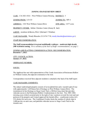
ZONING CHANGE REVIEW SHEET SITE AREA: 8.977 acres ZONING TO: MF-4 CASE: C14-2021-0161 – West William Cannon Housing DISTRICT: 5 ZONING FROM: LO-CO ADDRESS: 3101 West William Cannon Drive PROPERTY OWNER: Jubilee Christian Center (Jimmy R. Seal) AGENT: Armbrust & Brown, PLLC (Michael J. Whellan) CASE MANAGER: Wendy Rhoades (512-974-7719, wendy.rhoades@austintexas.gov) STAFF RECOMMENDATION: The Staff recommendation is to grant multifamily residence – moderate-high density (MF-4) district zoning. For a summary of the basis of Staff’s recommendation, see page 2. ZONING AND PLATTING COMMISSION ACTION / RECOMMENDATION: December 7, 2021: CITY COUNCIL ACTION: January 27, 2022: ORDINANCE NUMBER: ISSUES: The Applicant has met with representatives of the Condo Association at Persimmon Hollow on William Cannon, the adjacent community to the west. Correspondence received from adjacent residents is attached at the back of the Staff report. CASE MANAGER COMMENTS: The subject undeveloped property consists of seven platted lots and a vacated right-of-way with approximately 1,450 linear feet of frontage on West William Cannon Drive. The westernmost lot has frontage on Stage Coach Trail, a 200-foot long street that provides vehicular access to the Persimmon Hollow Condominiums to the west. Two 1995-1996 rezoning cases (which occurred prior to the right-of-way vacation) covered the west and east portions of the property and Council approved the limited office – conditional overlay (LO- CO) district for each case. The Conditional Overlay limits the number of vehicle trips to 2,000 per day on each case, and prohibits vehicular access to Stage Coach Trail on the western case. 1 of 20B-11 C14-2021-0161 Page 2 City maps show a creek buffer area running in a northerly to southerly direction through the western portion of the site and continuing to the 147 acre Stephenson Preserve to the south. Creek Buffers are unbuildable areas. There are single family residences in the Western Hills at Cherry Creek subdivision and apartments across William Cannon to the north (SF-3; SF-2; MF-2-CO), undeveloped land and a church to the east (LO-CO; LO); the Stephenson Preserve to the south (PUD), and attached condominiums across Stage Coach Trail to the west that also have frontage on William Cannon (SF-3). The Imagine Austin Growth Concept Map identifies West William Cannon Drive as an Activity Corridor which is a reflection of both land uses along a roadway and the available transportation options. Please refer to Exhibits A and A-1 – Zoning Map and Aerial Exhibit. The Applicant’s request is to rezone the property to the multifamily residence – moderate- high density (MF-4) district so that it may be developed with up to 300 apartment units. The Applicant’s conceptual plan shows that development will be located on the eastern portion of the site opposite existing apartments, and vehicular access would be taken to West William Cannon Drive. Please refer to Exhibit B – Applicant’s Conceptual Plan. BASIS OF RECOMMENDATION: 1. The proposed zoning should be consistent with the purpose statement of the district sought. The multi-family residence – moderate-high density (MF-4) district is intended for residential and multi-family use with a maximum density of up to 54 units per acre, depending on unit size and mix. This district is appropriate for multi-family residential areas located near supporting transportation and commercial facilities, generally in more centrally located areas. The property has access to West William Cannon Drive, an arterial and frontage on Stage Coach Trail, a local street which serves a condominium community. 2. Intensive multi-family zoning should be located on highways and major arterials. 3. Zoning changes should promote compatibility with adjacent and nearby uses. Staff recommends MF-4 zoning for the property based on the following considerations: 1) multifamily residential development is appropriate on William Cannon Drive, an arterial (Level 4) road and designated Activity Corridor, 2) it is suitable for residential development, consistent with multifamily residential developments to the north and east on William Cannon, and a multifamily development would assist towards accomplishing housing goals, and 3) the proposed development will be compact due to impervious cover restrictions within the Barton Springs Zone. 2 of 20B-11 C14-2021-0161 Page 3 EXISTING ZONING AND LAND USES: Site North South East West ZONING LO-CO SF-3; SF-2; RR-CO; MF-2-CO PUD LO-CO; LO; GR SF-3 LAND USES Undeveloped Single family residences in the Western Hills at Cherry Creek subdivision; Undeveloped; Apartments Stephenson Preserve Church; Apartments Persimmon Hollow Condominiums SCENIC ROADWAY: No NEIGHBORHOOD PLANNING AREA: Not Applicable TRAFFIC IMPACT ANALYSIS: Is not required WATERSHED: Williamson Creek Watershed – Barton Springs Zone (Recharge Zone) CAPITOL VIEW CORRIDOR: No SCHOOLS: Sunset Valley Elementary School Covington Middle School COMMUNITY REGISTRY LIST: 384 – Save Barton Creek Association 12 – Brodie Lane Homeowners Association 627 – Onion Creek Homeowners Association 511 – Austin Neighborhoods Council 943 – Save Our Springs Alliance 742 – Austin Independent School District 1343 – Oak Hill Trails Association 1228 – Sierra Club, Austin Regional Group 1424 – Preservation Austin 1363 – SEL Texas 1429 – Go Austin Vamos Austin 78745 1530 – Friends of Austin Neighborhoods 1531 – South Austin Neighborhood Alliance (SANA) 1550 – Homeless Neighborhood Association 1596 – TNR BCP – Travis County Natural Resources 1616 – Neighborhood Empowerment Foundation 1714 – East Oak Hill Neighborhood Association AREA CASE HISTORIES: 1774 – Austin Lost and Found Pets 1559 – Palomino Park HOA Crockett High School NUMBER C14-2014-0128 – The Vistas of Western Hills – 2910 West William Cannon Dr C814-98-0001 – The Forum PUD (Tract 4 / Parcel G and Tract 5 / Parcel REQUEST SF-2 to MF-2 SF-2 to PUD for approx 147 acres COMMISSION To Grant MF-2-CO w/CO for 2,000 vehicle trip limit / day, and Street Deed for r-o-w on W William Cannon To Grant PUD with conditions CITY COUNCIL Apvd MF-2-CO as Commission recommended (2-12-2015). Apvd PUD for the Preserve which is to be undeveloped except for trails, trail markers 3 of 20B-11 C14-2021-0161 Page 4 H) – south of W William Cannon Dr C14-95-0109 – 2900-3200 Block of W William Cannon Dr C14-94-0147 – Cherry Creek – 2900-3200 William Cannon Dr (even #s). C14-78-242 – City of Austin Planning C14-73-240 – Cannon West Shopping Center (Both sides of William Cannon) SF-2 to RR To Grant RR-CO Apvd MF-2-CO w/conds & direct Staff to initiate rezoning on adjacent greenbelt area zoned SF-2 (see C14-95-0109) SF-2 to MF Interim A Residence, First Height and Area to AA Residence, First Height and Area Interim A Residence, First Height and Area to BB Residence, First Height and Area (Tract B, located at 2809 W William Cannon, to the east) and development incidental to educational use (4-8-1999). Apvd RR-CO w/CO prohibiting community recreation (private and public), club or lodge, kennels, safety services, stables and telecommunications tower (6-27-1996). Apvd MF-2-CO w/CO for 12.44 units per acre (8-3-1995). Apvd BB Residence, First Height and Area (4-12-1979). Note: This converted to SF-2 zoning in 1984. Apvd BB Residence, First Height and Area (6-20-1974). Note: This converted to MF- 2 zoning in 1984. RELATED CASES: The rezoning area is platted as Lots 50-56, Western Hills, a subdivision recorded in 1953 (C8-1953-2104). The Ranch Road right-of-way located between Lots 53 and 54 was vacated by a vote of the Planning Commission on April 4, 2000 and recorded at the Travis County Clerk on April 6, 2000. On April 11, 1996, Council approved LO-CO zoning with the Conditional Overlay for a 2,000 daily vehicle trip limit for the eastern portion of the rezoning area (C14-95-0106 – Jubilee Christian Center). Also on April 11, 1996, Council approved LO-CO zoning with the Conditional Overlay for a 2,000 daily vehicle trip limit and prohibiting vehicular access to 4 of 20B-11 C14-2021-0161 Page 5 Stage Coach Trail for the western portion of the rezoning area (C14-95-0107 – Jubilee Christian Church / Wilke-Amey-Clay Funeral Home). EXISTING STREET CHARACTERISTICS: Name ROW Pavement Classification Sidewalks Bicycle Route Capital Metro (within ¼ mile) No Yes Yes Yes 43 feet Level 1 Level 4 Shared Lane None 95 – 100 feet 49 feet 43 feet West William Cannon Drive Stage Coach Trail OTHER STAFF COMMENTS: Comprehensive Planning This rezoning case is located on the south side of West William Cannon Drive on a 8.97 acre property that is undeveloped. It is also located along the William Cannon Road Activity Corridor and outside the boundaries of a small area plan. Surrounding land uses include a multifamily apartment complex and single-family houses to the north; to the south is Stephenson Nature Preserve and Outdoor Education Center; to the east is a church; and to the west are attached (two-unit) condominiums. The proposed land use is a 300-unit multifamily mid-rise apartment complex. Connectivity There are public sidewalks located along both sides of this portion of William Cannon Drive. A public transit stop is located directly in front of the property but there are no bike lanes located along this portion of William Cannon Drive. Retail uses and a park are located within a quarter of a mile radius. A grocery store is located a half mile to the west. The mobility and connectivity options in the area are average. Imagine Austin The Imagine Austin Comprehensive Plan (IACP) identifies this section of West William Cannon Drive as an Activity Corridor. Activity Corridors are intended to allow people to reside, work, shop, access services, people watch, recreate, and hang out without traveling far distances. They are characterized by a variety of activities and types of buildings located along the roadway — shopping, restaurants and cafés, parks, schools, single-family houses, apartments, public buildings, houses of worship, mixed-use buildings, and offices. The following Imagine Austin policies are applicable to this case: 5 of 20B-11 C14-2021-0161 Page 6 • LUT P1. Align land use and transportation planning and decision-making to achieve a compact and connected city in line with the growth concept map. • LUT P7. Encourage infill and redevelopment opportunities that place residential, work, and retail land uses in proximity to each other to maximize walking, bicycling, and transit opportunities. • HN P10. Create complete neighborhoods across Austin that have a mix of housing types and land uses, affordable housing and transportation options, and access to schools, retail, employment, community services, and parks and recreation options. Based on this property: (1) being situated along an Activity Corridor, which supports multifamily uses; (2) other residential uses, including multifamily, being located within a quarter mile radius of this site; (3) adding new residential units in support of the Strategic Housing Blueprint; and (4) the connectivity and mobility strengths available in the area, this project supports the policies of the Imagine Austin Comprehensive Plan. 6 of 20B-11 C14-2021-0161 Page 7 7 of 20B-11 C14-2021-0161 Page 8 Drainage The developer is required to submit a pre- and post-development drainage analysis at the subdivision and site plan stage of the development process. The City’s Land Development Code and Drainage Criteria Manual require that the Applicant demonstrate through engineering analysis that the proposed development will have no identifiable adverse impact on surrounding properties. There is a regional water quality / detention facility that will serve this site, therefore onsite drainage facilities will not be provided. Environmental This site is located over the Edwards Aquifer Recharge Zone. The site is in the Williamson Creek Watershed of the Colorado River Basin, which is classified as a Barton Springs Zone Watershed by Chapter 25-8 of the City’s Land Development Code. It is in the Drinking Water Protection Zone. Project applications at the time of this report are subject to the SOS Ordinance that allows 15% impervious cover in the Recharge Zone. A Water Quality Transition Zone / Critical Water Quality Zone exist within the project location. Standard landscaping and tree protection will be required in accordance with LDC 25-2 and 25-8 for all development and/or redevelopment. At this time, site specific information is unavailable regarding vegetation, areas of steep slope, or other environmental features such as bluffs, springs, canyon rimrock, caves, sinkholes, and wetlands. Under current watershed regulations, development or redevelopment requires water quality control with increased capture volume and control of the 2-year storm on site. Runoff from the site is required to comply with pollutant load restrictions as specified in Land Development Code. Impervious Cover Within the Barton Springs Zone portion of the Williamson Creek watershed, the maximum impervious cover allowed by the MF-4 zoning district is 15%, which is based on the more restrictive watershed regulations. PARD – Planning & Design Review Parkland dedication will be required at the time of subdivision or site plan application for new residential units, per City Code § 25-1-601, as amended. The proposed development meets the criteria for land dedication in City Code Title 25, Article 14. As such, a partial land dedication will be required, as well as any remaining fees in-lieu. 8 of 20B-11 C14-2021-0161 Page 9 The development is adjacent to Stephenson Preserve, and includes a segment of a Williamson Creek tributary, thereby meeting several of the criteria for dedication per § 25-1- 605 (B). The development as proposed will require parkland dedication for the new residential units that will serve the surrounding neighborhood through the additional park investment. The Parks and Recreation Department (PARD) would consider a connection along the creek toward satisfying the requirement at time of permitting (whether subdivision or site plan). Such a connection would improve neighborhood connectivity, and satisfy a connection with Williamson Creek, a recommendation identified in the Parks and Recreation Department’s Long Range Plan. Should there be any remaining fees in-lieu, those fees shall be used toward park investments in the form of land acquisition and/or park amenities within the surrounding area, per the Parkland Dedication Operating Procedures § 14.3.11 and City Code § 25-1-607 (B)(1) & (2). Should the applicant wish to discuss parkland dedication requirements in advance of site plan or subdivision applications, please contact this reviewer: thomas.rowlinson@austintexas.gov. At the applicant’s request, PARD can provide an early determination letter of the requirements as stated in this review. Site Plan and Compatibility Standards Any new development is subject to Subchapter E. Design Standards and Mixed Use. Additional comments will be made when the site plan is submitted. The site is subject to compatibility standards. Along the north and west property lines, the following standards apply: a. No structure may be built within 25 feet of the property line. b. No structure in excess of two stories or 30 feet in height may be constructed within 50 c. No structure in excess of three stories or 40 feet in height may be constructed within 100 feet of the property line. feet of the property line. d. No parking or driveways are allowed within 25 feet of the property line. e. A landscape area at least 25 feet wide is required along the property line. In addition, a fence, berm, or dense vegetation must be provided to screen adjoining properties from views of parking, mechanical equipment, storage, and refuse collection. Additional design regulations from LDC 25-2-1067 include the following: • Exterior lighting must be hooded or shielded so that the light source is not directly visible from adjacent property: (1) in an urban family residence (SF-5) or more restrictive district (2) on which a use permitted in an SF-5 or more restrictive zoning district is located • The noise level of mechanical equipment may not exceed 70 decibels at the property line. 9 of 20B-11 C14-2021-0161 Page 10 • A permanently placed refuse receptacle, including a dumpster, may not be located 20 feet or less from property: (1) in an SF-5 or more restrictive zoning district; or (2) on which a use permitted in an SF-5 or more restrictive zoning district is located. Density limits for MF-4 For sites zoned MF-4, the minimum site area for each dwelling unit is: (1) 800 square feet, for an efficiency dwelling unit; (2) 1,000 square feet, for a one-bedroom dwelling unit; and (3) 1,200 square feet, for a dwelling unit with two or more bedrooms. Transportation ASMP Assessment The Austin Strategic Mobility Plan (ASMP) calls for 120 feet of right-of-way for W William Cannon Drive and 50 feet of right-of-way for Stage Coach Trail. It is recommended that 60 feet of right-of-way from the existing centerline should be dedicated for W William Cannon Drive and 25 feet of right-of-way from the existing centerline should be dedicated for Stage Coach Trail according to the Transportation Plan with the first subdivision or site plan application [LDC 25-6-51 and 25-6-55]. Transportation Assessment Assessment of required transportation mitigation, including the potential dedication of right of way and easements and participation in roadway and other multi-modal improvements, will occur at the time of site plan application. A traffic impact analysis shall be required at the time of site plan if triggered per LDC 25-6-113. Austin Water Utility The landowner intends to serve the site with City of Austin water and wastewater utilities. The landowner, at own expense, will be responsible for providing any water and wastewater utility improvements, offsite main extensions, utility relocations and or abandonments required by the land use. The water and wastewater utility plan must be reviewed and approved by Austin Water for compliance with City criteria and suitability for operation and maintenance. Depending on the development plans submitted, water and or wastewater service extension requests may be required. All water and wastewater construction must be inspected by the City of Austin. The landowner must pay the City inspection fee with the utility construction. The landowner must pay the tap and impact fee once the landowner makes an application for a City of Austin water and wastewater utility tap permit. 10 of 20B-11 C14-2021-0161 Page 11 INDEX OF EXHIBITS AND CORRESPONDENCE TO FOLLOW: Exhibit A: Zoning Map Exhibit A-1: Aerial Map Exhibit B: Applicant’s Conceptual Plan Correspondence Received 11 of 20B-11 ( ( ( ( SF-2-NP ( ( ( ( ( ( SF-2-NP ( ( ( ( ( ( ( R Y D L ( ( E H D A ( ( SF-2-NP B U S H N E L ( L D R ( ( ( C14-2014-0019 ( ( ( ( ( SF-2-NP ( ( ( ( ( RR-CO C14-95-0109 ( ( ( ( L A N C ( R E ( T H I L ( L D R ( SF-2-NP ( ( ( ( ( ( ( ( ( ( ( MF-2-CO SP96-0115C C14-94-0147 ( ( ( ( ( 95-0109 C14-95-0109 RR-CO C14-2016-0045 MF-2 ( ( ( ( ( ( C14-78-242 ( ( ( SF-2 ( ( ( ( ( ( ( ( ( ( ( ( ( ( ( ( GR ( ( SF-3 SF-3 D UPLEXES G ALLO ( ( ( ( ( P C V ( ( ( ( ( ( W E S T E R ( ( ( ( ( N D R ( ( SF-3 ( ( SF-3 D U PLE XE S LOST VALLEY ( ( ( ( ( ( SF-2 ( ( ( ( C14-78-242 ( ( ( T S E L D D A S E D S I ( ( ( ( ( ( ( ( ( ( ( ( ( ( ( D R N E D R A E R ( ( ( ( ( ( ( ( ( ( ( ( LARIAT WAY ( ( ( ( ( ( ( ( ( SF-2 ( ( ( ( ( ( ( ( ( ( ( ( ( ( ( ( SF-2 ( ( ( ( ( ( ( ( ( ( ( ( ( ( L R T H C A O C E G A T S ( ( SF-2 ( ( ( ( ( ( ( ( ( SF-3 ( ( ( ( ( ! ! ! ! ! ! ! ! ! ! ! ! ! ! ! ! ! ! ! ! UNDEV ! ! ! LO-CO ! C14-95-0107 ! ! ! ! ! ! ! SF-2 79-251 ! ! ! D H R C N A R ! ! ! ! ! ! 95-0107 ! ! ! ! ! ! ! ! ! ! APARTMENTS ! ! ! ! ! ! W WILLIA ! ! ! ! UNDEV ! ! M C A N N O N D R ! ! LO-CO ! ! ! ! C14-95-0106 CHURCH 95-0106 79-251 MF-2-CO C14-2014-0128 81-124 SP-04-1091C.SH p83-026 MF-2 GR-NP P83-053 LO 73-240 GR 78-200 ( PUD C814-98-0001 MF-1 SF-3 ( ( ( ALDERWOOD DR ( ( R L D IL H N O T A E D ( ( ( ( ( SF-3 ( ( R L D HIL N A G E ( ( ( ( ( SF-3 ( B R Y O N H ( ( ( ALL D R ( SF-3 ( ( ( ( ( ( ( ( ( ( ( ( ( ( ( C H A RLE S W D E E RIN G ( ( HILL D R ( SF-3 ( ( SF-3 ( ( SF-3 ( ( ( O R TH D R ( ( ( ( ( ( ( ( ( ( PAIS ( SF-3 ( A N O T RL ( ( ( ( ± SUBJECT TRACT ! ! ! ! ! ! PENDING CASE ZONING BOUNDARY ZONING Exhibit A ZONING CASE#: C14-2021-0161 This product is for informational purposes and may not have been prepared for or be suitable for legal, engineering, or surveying purposes. It does not represent an on-the-ground survey and represents only the approximate relative location of property boundaries. 1 " = 400 ' This product has been produced by the Housing and Planning Department for the sole purpose of geographic reference. No warranty is made by the City of Austin regarding specific accuracy or Created: 10/6/2021 12 of 20B-11 23 24 25 26 MF-2 22 21 19 20 16 14 12 10 18 17 SF-2 15 11 13 9 8 7 5 GR 27 28 29 30 31 SF-3 LOST VALLEY 10 14 12 9 13 11 15 G 16 ALLO 25 P C V 26 17 18 8 7 6 19 20 27 24 23 28 29 30 11 10 9 8 12 13 14 15 16 17 7 6 SF-2 11 10 9 8 12 13 14 7 SF-2 5 D R N E D R A E R 6 5 4 3 2 T S E L D D A S E D S I 18 19 20 21 22 23 13 12 11 W E 10 W WILLIA M C 1 SF-3 13 12 11 22 31 32 S T E R 9 8 A N N O 21 SF-2 33 34 N D 7 6 R N D R 5 4 3 2 1 5 4 10 9 8 7 SF-3 6 5 2 1 3 1 4 3 2 4 3 24 1 2 25 LARIAT WAY 21 20 19 18 15 16 17 18 19 20 4 3 2 1 E G A T S L R T H C A O C 17 16 14 13 15 SF-2 11 12 10 9 8 1 2 3 SF-3 4 5 7 6 65 50 51 SF-2 MF-2-CO 64 63 LO-CO 52 H C N D A R R 53 62 61 C14-2021-0161 54 W WILLIA E17 55 LO-CO M C A N N O N D R 56 57 PUD 8 7 11 6 12 13 5 4 3 19 4 14 17 16 2 18 19 20 21 17 14 15 16 R Y D L 36 37 35 15 38 A N C R E 22 T 34 33 39 SF-2-NP 2 1 A E H L D 24 23 RR-CO 41 H I L L D R 21 20 19 18 17 16 15 14 42 43 44 45 31 5 4 46 47 48 13 12 11 10 9 8 60 58 MF-2-CO 1 59 MF-2 2 LO GR 1 SF-3 3 2 4 MF-1 ALDERWOOD DR 1 10 9 SF-3 12 B R Y 11 O N H D 10 13 R ALL 9 8 SF-3 15 7 16 9 8 8 7 15 16 17 6 5 17 18 4 5 SF-3 3 HILL R D 12 N A G E 6 7 8 11 10 13 9 D E E 12 RIN D R 9 SF-3 15 7 6 G HILL 5 Copyright nearmap 2015 9 17 16 18 4 1 SF-3 3 N PAIS 4 2 3 22 21 19 A 5 6 O T 7 RL 8 9 10 ± 1'' = 400' SUBJECT TRACT ZONING BOUNDARY ! ! ! ! ! ! PENDING CASE CREEK BUFFER West William Cannon Housing Exhibit A - 1 ZONING CASE#: LOCATION: SUBJECT AREA: GRID: MANAGER: C14-2021-0161 3101 West William Cannon Drive 8.977Acres E17 Wendy Rhoades This map has been produced by the Communications Technology Management Dept. on behalf of the Planning Development Review Dept. for the sole purpose of geographic reference. No warranty is made by the City of Austin regarding specific accuracy or completeness. 13 of 20B-11 WEST WILLIAM CANNON DRIVE 294 UNITS 5b LEVELS 5a LEVELS COURTYARD 7,680 PERVIOUS 15,180 SF IMPERVIOUS 12,350 SF PERVIOUS BLDG TABULATIONS: LVL SF/LVL GROSS SF NET SF 5a 104,830 139,390 5b TOTAL 244,220 132,700 176,450 309,150 26,540 35,290 UNITS TOTAL 126 168 294 UNIT SF AVE. 832 830 831 PARKING TABULATIONS: 6 LVL 465 SP 6 LVL PKG RATIO 1.58 SP/UNIT SITE TABULATIONS: SITE AREA BLDG AREA PAVING AREA 412,687 SF 89,045 SF 15,180 SF IMPERVIOUS 104,225 SF % 25.2 West William Cannon Drive STILLWATER CAPITAL SP-03 14 of 20B-11 From: To: Subject: Date: Rhoades, Wendy 3101 W. William Cannon Drive Project Friday, November 12, 2021 4:15:03 PM *** External Email - Exercise Caution *** Hello Ms. Rhoades, I live on William Cannon very close to the multifamily residence intended to be built at 3101 W. William Cannon Drive. (Case number C14-2021-0161) I am extremely troubled by this plan for a multifamily resident, or any building, to be built there. This part of William Cannon is already so congested. The traffic would make it almost impossible for me to turn left out of my apartment; it's already very difficult as it is. I'm additionally troubled by the noise and light pollution the construction would cause. Even more importantly, we cannot afford to continue building apartments in these untouched green spaces. We are losing too many and this once beautiful green city is turning into a concrete parking lot with plywood condos shoved in every corner. We are in the middle of a climate emergency and we cannot just build projects like this wherever we want without major, irrevocable damage and cost to our environment -- for us and future generations. This space is so beautiful and sacred. I've been walking to it for 11 years to watch the sunsets. It would be absolutely devastating and extremely troubling to have yet another apartment complex built here. We need more green spaces. I, along with my neighbors and fellow residents, will do everything possible to stop this. I am urging you to as well. Thank you, Eva Lorini (412) 260 - 7791 -- Eva Lorini, LPC Goes by she/her/hers CAUTION: This email was received at the City of Austin, from an EXTERNAL source. Please use caution when clicking links or opening attachments. If you believe this to be a malicious and/or phishing email, please forward this email to cybersecurity@austintexas.gov. 15 of 20B-11 16 of 20B-11 P E T I T I O N Date: December 4, 2021 Case File Number: C14-2021-0161 Address of Rezoning Request: 3101 West William Cannon Drive To: Austin City Council We, the undersigned owners of property affected by the requested zoning change described in the referenced file, do hereby protest against any change of the Land Development Code which would zone the property to any classification other than the existing zoning code of LO-CO – Limited Office district with Conditional Overlay, and certain single family residence zoning options such as SF-3, for single family residence. As members of the relevant surrounding neighborhood, we write to express our protest and concern over the moderate-high density proposed housing district for the plot at 3101 West William Cannon Drive. The zoning category in question is an unnecessary departure from the typical zoning for the surrounding neighborhood, which is nearly universally within the single family home category. While we, the petitioners, are not opposed to denser housing, we believe any rezoning should weigh the strains that a major development will likely have on (1) the difficult section of William Cannon the units are proposed to be built on, (2) the impact to one of the few contiguous greenspaces in this section of the city, and (3) additional challenges created by such a building to a difficult flood zone. The section of William Cannon in question was built for single family homes and the traffic they generate in mind. You can see this in the construction of the winding road that connects into quick turnoffs. The situation on William Cannon is already dangerous in this area. Just within the last two weeks, a driver slammed directly into the fence line of several neighbors, luckily hurting no one but impressing the point that the section of road in question is complex to navigate today. Adding a building the traffic demands equivalent to an entirely new neighborhood may push safety over the edge. However, we can see from duplexes adjacent to William Cannon today that a less dense housing structure creates fewer problems. In addition, some residents here remain concerned about the environmental impact these buildings will have to a section of the city in need of protected green space. The area of land to be developed comprises one of the few connective corridors between the Stephenson Nature Preserve and the South Hills Conservation Area. Stephenson has become a needed wildlife area in this section of the city, and the fact that the green space is one of the longest stretches of connected space is a value that will become increasingly difficult to replicate with the City’s expansion. In addition, the Preserve has long been neglected, with additional public access points near William Cannon being effectively non-existent. The petitioners would submit that a less dense zoning would materially mitigate the impact to the preserve, preventing a level of activity that will adversely affect the wildlife, while still allowing the City to meet its needs for greater housing in the area. 17 of 20B-11 Finally, the petitioners would like the city to consider the possible challenging impact of this development on the nearby flood zone. The neighborhoods directly adjacent and north of this proposed complex are highly prone to flooding and have been severely impacted by floods in the area previously. Residents still recall the Halloween flood several years ago that left sections of William Cannon in this exact location effectively impassable. With such a large amount of impervious ground cover created by a building of this size, it appears inevitable that the damage to the surrounding area from future flooding could be augmented materially. We appreciate the opportunity to offer our perspective as actual neighbors to the lot in question. While we would welcome appropriate uses of the land, some of which could add needed housing, the undersigned believe the current proposed rezoning asks too much of a unique and sensitive location. Consequently, we hereby protest the change and ask city officials to consider a more appropriate designation for this location. (PLEASE USE BLACK INK WHEN SIGNING PETITION TO FACILITATE REPRODUCTION) Signature __________________________ __________________________ __________________________ __________________________ __________________________ __________________________ __________________________ __________________________ __________________________ __________________________ __________________________ __________________________ __________________________ __________________________ __________________________ __________________________ __________________________ __________________________ __________________________ __________________________ __________________________ __________________________ __________________________ __________________________ __________________________ __________________________ __________________________ __________________________ Printed Name __________________________ __________________________ __________________________ __________________________ __________________________ __________________________ __________________________ __________________________ __________________________ __________________________ __________________________ __________________________ __________________________ __________________________ __________________________ __________________________ __________________________ __________________________ __________________________ __________________________ __________________________ __________________________ __________________________ __________________________ __________________________ __________________________ __________________________ __________________________ Address __________________________ __________________________ __________________________ __________________________ __________________________ __________________________ __________________________ __________________________ __________________________ __________________________ __________________________ __________________________ __________________________ __________________________ __________________________ __________________________ __________________________ __________________________ __________________________ __________________________ __________________________ __________________________ __________________________ __________________________ __________________________ __________________________ __________________________ __________________________ 18 of 20B-11 __________________________ __________________________ __________________________ __________________________ __________________________ __________________________ __________________________ __________________________ __________________________ __________________________ __________________________ __________________________ __________________________ __________________________ __________________________ __________________________ __________________________ __________________________ __________________________ __________________________ __________________________ __________________________ __________________________ __________________________ __________________________ __________________________ __________________________ __________________________ __________________________ __________________________ __________________________ __________________________ __________________________ __________________________ __________________________ __________________________ __________________________ __________________________ __________________________ __________________________ __________________________ __________________________ __________________________ __________________________ __________________________ __________________________ __________________________ __________________________ __________________________ __________________________ __________________________ __________________________ __________________________ __________________________ __________________________ __________________________ __________________________ __________________________ __________________________ __________________________ __________________________ __________________________ __________________________ __________________________ __________________________ __________________________ __________________________ __________________________ __________________________ __________________________ __________________________ __________________________ __________________________ __________________________ __________________________ __________________________ __________________________ __________________________ __________________________ __________________________ __________________________ __________________________ __________________________ __________________________ __________________________ __________________________ __________________________ __________________________ __________________________ __________________________ __________________________ __________________________ __________________________ __________________________ __________________________ __________________________ __________________________ __________________________ __________________________ __________________________ __________________________ __________________________ __________________________ __________________________ __________________________ __________________________ __________________________ __________________________ __________________________ __________________________ __________________________ __________________________ __________________________ __________________________ __________________________ __________________________ __________________________ __________________________ __________________________ __________________________ __________________________ __________________________ __________________________ __________________________ __________________________ __________________________ __________________________ __________________________ __________________________ __________________________ __________________________ __________________________ __________________________ __________________________ __________________________ __________________________ __________________________ __________________________ 19 of 20B-11 __________________________ __________________________ __________________________ __________________________ __________________________ __________________________ __________________________ __________________________ __________________________ __________________________ __________________________ __________________________ __________________________ __________________________ __________________________ __________________________ __________________________ __________________________ __________________________ __________________________ __________________________ __________________________ __________________________ __________________________ __________________________ __________________________ __________________________ __________________________ __________________________ __________________________ __________________________ __________________________ __________________________ __________________________ __________________________ __________________________ __________________________ __________________________ __________________________ __________________________ __________________________ __________________________ __________________________ __________________________ __________________________ __________________________ __________________________ __________________________ __________________________ __________________________ __________________________ Date: December 4, 2021 Contact Name: _________________________ Phone Number: _________________________ Contact Name: _________________________ Phone Number: _________________________ Contact Name: _________________________ Phone Number: _________________________ 20 of 20B-11