B-08 (C14-2021-0003 - Sun Auto; District 6).pdf — original pdf
Backup
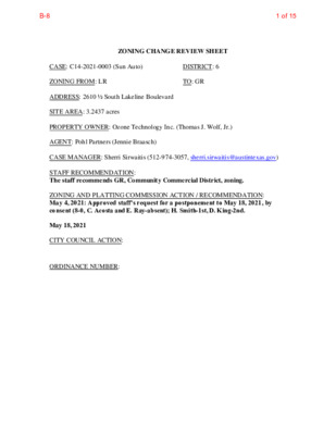
ZONING CHANGE REVIEW SHEET CASE: C14-2021-0003 (Sun Auto) DISTRICT: 6 ZONING FROM: LR TO: GR ADDRESS: 2610 ½ South Lakeline Boulevard SITE AREA: 3.2437 acres PROPERTY OWNER: Ozone Technology Inc. (Thomas J. Wolf, Jr.) AGENT: Pohl Partners (Jennie Braasch) CASE MANAGER: Sherri Sirwaitis (512-974-3057, sherri.sirwaitis@austintexas.gov) STAFF RECOMMENDATION: The staff recommends GR, Community Commercial District, zoning. ZONING AND PLATTING COMMISSION ACTION / RECOMMENDATION: May 4, 2021: Approved staff's request for a postponement to May 18, 2021, by consent (8-0, C. Acosta and E. Ray-absent); H. Smith-1st, D. King-2nd. May 18, 2021 CITY COUNCIL ACTION: ORDINANCE NUMBER: 1 of 15B-8 C14-2021-0003 ISSUES: N/A CASE MANAGER COMMENTS: 2 The property in question is undeveloped and moderately vegetated. There is floodplain along the eastern portion of the tract (please see Aerial Map – Exhibit B). The site is located to the northwest of Lakeline Mall on South Lakeline Boulevard. The front portion of this property is within the City of Austin and takes access to S. Lakeline Boulevard. The rear portion of this tract of land is within the City of Cedar Park’s jurisdiction and has access of off West Rivera Circle, a residential collector street. There is undeveloped land and a single-famil y residential neighborhood to the north. To the east of this site, along Lakeline Boulevard, there is a floodplain area and a multifamily use/apartment complex (The Park at Lakeline). To the west there is an undeveloped lot within the City of Cedar Park. The parcel to the south, across S. Lakeline Boulevard, zoned P and is parkland (Lakeline Neighborhood Park). The applicant is requesting Community Commercial zoning for this tract of land so that they may develop automotive uses on the property. The staff recommends GR, Community Commercial District, zoning. The property meets the purpose statement of the Community Commercial district as it is located on an arterial roadway and will provide services to the surrounding community. The site under consideration has constraints as only a corner (western portion) of this property is developable because of floodplain. The applicant has proposed an office concept plan for the portion of this tract of land to adjacent the residential neighbors in Cedar Park, which would provide for a transition for the proposed commercial uses along S. Lakeline Boulevard to the office uses and the single family residences to the north (please see Correspondence Received - Exhibit C). GR zoning will permit the applicant to develop office, civic or commercial uses on the site to provide services to the multifamily development to the east and the single-family residential neighborhoods to the north and the southwest. GR zoning is appropriate fronting an arterial roadway, Lakeline Boulevard, across from a public park and the Lakeline Mall development to the south. The property is located 0.75 miles from the ‘Lakeline Station Regional Center’, as identified on the Imagine Austin’s Growth Concept Map, found in the Image Austin Comprehensive Plan. The applicant agrees with the staff’s recommendation. BASIS OF RECOMMENDATION: 1. The proposed zoning should be consistent with the purpose statement of the district sought. Community Commercial district is intended for office and commercial uses serving neighborhood and community needs, including both unified shopping centers and individually developed commercial sites, and typically requiring locations accessible from major traffic ways. 2 of 15B-8 C14-2021-0003 3 2. The proposed zoning should allow for a reasonable use of the property. The proposed zoning would allow for a f air and reasonable use of the property because it will provide the opportunity for the applicant to develop a mixture of office and commercial development on this site adjacent to existing residential uses to the north, east and southwest. The property is located near a Regional Center a designated by the Imagine Austin Comprehensive Plan. EXISTING ZONING AND LAND USES: ZONING LAND USES Site North County LR South East West P SF-6, MF-3 County Undeveloped Undeveloped Tract, Single-Family Residential Neighborhood Undeveloped Multifamily (The Park at Lakeline) Office, Single-Family Residential NEIGHBORHOOD PLANNING AREA: N/A TIA: Not Required WATERSHED: Buttercup Creek SCHOOLS: Round Rock I.S.D. Sommer Elementary School Elsa England Elementary School Pearson Ranch Middle School McNeil High School NEIGHBORHOOD ORGANIZATIONS: Bike Austin City of Cedar Park Riviera Springs Community Development Association Friends of Austin Neighborhoods Leander ISD Population and Survey Analysts Neighborhood Empowerment Foundation SELTEXAS Sierra Club, Austin Regional Group 3 of 15B-8 C14-2021-0003 4 AREA CASE HISTORIES: REQUEST SF-6 to GR COMMISSION 8/06/13: Approved staff’s recommendation of LR zoning by consent (5-0, B. Baker & C. Banks-absent); R. McDaniel-1st, S. Compton-2nd. CITY COUNCIL 8/29/13: Approved LR zoning on all 3 readings (7-0); L. Morrison-1st, S. Cole-2nd. SF-6 to GR N/A N/A NUMBER C14-2013-0074 (Ozone Technology Inc.: 2610 ½ South Lakeline Boulevard) C14-2008-0201 (OTI: South Lakeline near Ridgeline Blvd.) C14-06-0134 (Lakeline Commons: North FM 620 at Ridgeline Boulevard) CH, CS, GR- CO, LO-CO to GR-MU 10/19/06: Approved ZAP Commission recommendation of GR-MU-CO zoning for Tract 1 and LO-CO zoning for Tract 2 with an exception to allow a 45 foot building height with a 200 foot setback (6- 0, Council Member Martinez- off the dais); L. Leffingwell-1st, S. Cole- 2nd. Staff was directed to bring back in the ordinance or in the form of a restrictive covenant those items requested by the neighborhood and agreed to by the applicant. 11/30/06: Approved GR-MU-CO zoning for Tract 1 and LO-CO zoning for Tract 2(6-0); 2nd/3rd readings 9/15/09: Case expired the from from Section 9/05/06: Approved GR-MU-CO zoning for Tract 1 and LO-CO zoning for Tract 2 with conditions of: For Tracts 1 & 2 (the following conditions were adopted existing ordinance for this tract of land (Ordinance No. 970710-A): 1) Outdoor Sports and Recreation and Outdoor Entertainment uses are prohibited on the Property; 2) The following uses are prohibited on the Property within an area 300-feet the easternmost property line of the Shenendoah 5 Subdivision: Automotive Repair Services, Automotive Washing type), Restaurant (of (General), Restaurant (Limited),- Theater, Indoor Entertainment, Club or Lodge; 3) No building of any kind shall be constructed within an area 100-feet from the easternmost property line of the Shenendoah 5 Subdivision; 4) No structure of any kind shall be built to a height greater than 30-feet above ground level within the area beginning 100-feet from the easternmost property line of the Shenendoah Section 5 Subdivision to a depth of 200-feet westerly from the 100-foot point. 6) Beyond the above no structure of any kind shall be 200-foot Section depth, any 4 of 15B-8 C14-2021-0003 5 Vote: (7-1, K. Jackson-Nay, J. Shieh-absent); J. Pinnelli-1st, T. Rabago-2nd. GR to GR-MU 5/23/00: Approved staff rec. of GR-MU by consent (8-0) C14-00-2058 (Pecan Park: Pecan Park Boulevard) C14-95-0149 (Lakeline- Tract 26: Ridgeline Boulevard) MF-3 to GR 6/22/00: Approved GR-MU on all 3 readings (7-0) 7/11/96: Approved GR-CO (Tract 1) and LO-CO (Tract 2) with conditions (6-1, JD-No); 1st reading 7/10/97: Approved 2nd/3rd readings (7-0) of: conditions built to a height greater than 35- feet above ground level. 7)Added new No development within the LO-CO tract (Tract 2); The applicant shall vegetate/re-vegetate the LO-CO area (Tract 2); The applicant will provide an 8-foot stone or masonry fence along the western property line adjacent to the 5 Subdivision. Shenedoah Section 4/23/96: Approved GR for Tract 1 and LO for Tract 2 (9-0), with the following conditions: prohibit Outdoor Sports and Recreation and Outdoor Entertainment uses; prohibit Automotive Repair Services, Automotive Washing, Restaurant (Limited, General), Theater, Indoor Entertainment, and Club or Lodge uses within an area 300 feet from the western property line; no building shall be constructed within and area 100 feet from the easternmost property line of the Shenendoah Section 5 Subdivision; limit building height to 30 feet within an area 100 feet from the easternmost property line of the Shenendoah Section 5 Subdivision to a depth of 200 feet; beyond the 200 foot depth limit building height to no greater than 35 feet; and on Tract 2 a privacy fence shall be constructed on the westernmost property line adjacent to the Shenendoah Section 5 Subdivision 5 of 15B-8 6 C14-2021-0003 RELATED CASES: Previous Zoning Cases: C14-2013-0074 C14-2008-0201 EXISTING STREET CHARACTERISTICS: Lakeline Blvd OTHER STAFF COMMENTS: Site Characteristics Name Existing ROW Pavement ASMP Sidewalks Bicycle Classification Route ASMP Required ROW 85’ 120' 50' 3 No Yes Capital Metro (within ¼ mile) No The subject tract is currently undeveloped and moderately vegetated. The property to the north is an undeveloped tract that is zoned Local Retail-Conditional Overlay District within the City of Cedar Park. This tract of land backs up to an established single-family residential neighborhood. To the east, there is floodplain and a multifamily complex. To the south, there is undeveloped land. The tract of land to the west, across S. Lakeline Boulevard, is developed with an office complex that backs up to a single-family residential neighborhood. Comprehensive Planning This zoning case is located on the north side of South Lakeline Boulevard, on an undeveloped property that is approximately 1.25 acres in size. The property is located 0.75 miles from the Lakeline Station Regional Center and is not located within the boundaries of a neighborhood planning area with an adopted plan. Surrounding land uses includes vacant land and single family houses the north; to the south is Lakeline Neighborhood Park; to the east is an apartment building; and to the west is a medical office and corporate office buildings. The proposed use is an automotive repair shop. Connectivity There are no public sidewalks located along this portion of South Lakeline Boulevard. One side of the road has an unprotected bike lane. There is no public transit stop is located within a half of a mile from the site. Mobility options are below average while connectivity options are fair but require the use of a car. Imagine Austin and Conclusions The property is located 0.75 miles from the ‘Lakeline Station Regional Center’, as identified on the Imagine Austin’s Growth Concept Map, found in the Image Austin Comprehensive Plan. A Regional Center is the most urban of the three activity centers outlined in the growth concept map. These centers are the places where the greatest density of people and jobs and the tallest buildings in the region will be located. Like many Imagine Austin Centers, this 6 of 15B-8 C14-2021-0003 7 center is represented by a circle or globular shape that reflects the general location where the center should be located in the future. The center’s actual boundaries would need to be clarified through a small area planning process. Regional, town, and neighborhood centers are supposed to be walkable, bikeable, and supported by transit. The following Imagine Austin policies are applicable to this case: • LUT P1. Align land use and transportation planning and decision-making to achieve a compact and connected city in line with the growth concept map. • LUT P3. Promote development in compact centers, communities, or along corridors that are connected by roads and transit, are designed to encourage walking and bicycling, and reduce healthcare, housing and transportation costs. • LUT P5. Create healthy and family-friendly communities through development that includes a mix of land uses and housing types and affords realistic opportunities for transit, bicycle, and pedestrian travel and provides both community gathering spaces, parks and safe outdoor play areas for children. Analysis Analyzing this specific site, there seems to be a lack of mobility options (protected bike lanes, public sidewalks and public transit) and nearby goods and services and public amenities only accessible by car. Based on this property being located by along a major arterial road and near an Regional Center, which supports commercial uses but the lack of mobility options the area (public sidewalks, bike lanes, and transit stops), this project appears to only partially support the Imagine Austin Comprehensive Plan. Environmental The site is located over the North Edwards Aquifer Recharge Zone. The site is in the Buttercup Creek Watershed, which is classified as a Suburban Watershed by Chapter 25-8 of the City's Land Development Code. It is in the Desired Development Zone. Under current watershed regulations, development or redevelopment on this site will be subject to the following impervious cover limits: Development Classification % of Gross Site Area % of Gross Site Area with Single-Family Residential (min. lot size 5750 sq. ft.) One or Two Family Residential (lot size < 5750 sq. ft.) Multifamily Residential Commercial 45% 55% 60% 65% Transfers 50% 60% 65% 70% According to floodplain maps there is a floodplain within or adjacent to the project location. Based upon the location of the floodplain, offsite drainage should be calculated to determine whether a Critical Water Quality Zone exists within the project location. 7 of 15B-8 C14-2021-0003 8 Standard landscaping and tree protection will be required in accordance with LDC 25-2 and 25-8 for all development and/or redevelopment. At this time, site specific information is unavailable regarding vegetation, areas of steep slope, or other environmental features such as bluffs, springs, canyon rimrock, caves, sinkholes, and wetlands. Under current watershed regulations, development or redevelopment requires water quality control with increased capture volume and control of the 2-year storm on site. At this time, no information has been provided as to whether this property has any ls that preempt current water quality or Code requirements. Fire No comments. Parks and Recreation Site Plan There are currently no parkland requirements for uses other than residential and hotel. Given that the application is for GR, there would not be parkland dedication requirements or parkland impacts at the time of site plan or subdivision. Site plans will be required for any new development other than single-family or duplex residential. Any development which occurs in an SF-6 or less restrictive zoning district which is located 540 feet or less from property in an SF-5 or more restrictive zoning district will be subject to compatibility development regulations. Any new development is subject to Subchapter E. Design Standards and Mixed Use. Additional comments will be made when the site plan is submitted. FYI: Additional design regulations will be enforced at the time a site plan is submitted. DEMOLITION AND HISTORIC RESOURCES The applicant is responsible for requesting relocation and demolition permits once the site plan is approved. The City Historic Preservation Officer will review all proposed building demolitions and relocations prior to site plan approval. If a building meets city historic criteria, the Historic Landmark Commission may initiate a historic zoning case on the property. 8 of 15B-8 C14-2021-0003 Transportation 9 The Austin Strategic Mobility Plan (ASMP), adopted 04/11/2019, identifies a need for 120’ of right- of-way for Lakeline Boulevard. Right-of-way should be dedicated for Lakeline Boulevard at the time of subdivision or site plan. Traffic impact analysis was waived, the TIA determination is deferred to site plan submittal, when land use and intensity will be finalized. Austin Water Utility The landowner intends to serve the site with City of Austin water and wastewater utilities. The landowner, at own expense, will be responsible for providing any water and wastewater utility improvements, offsite main extensions, utility relocations and or abandonments required by the land use. The water and wastewater utility plan must be reviewed and approved by Austin Water for compliance with City criteria and suitability for operation and maintenance. Depending on the development plans submitted, water and or wastewater service extension requests may be required. All water and wastewater construction must be inspected by the City of Austin. The landowner must pay the City inspection fee with the utility construction. The landowner must pay the tap and impact fee once the landowner makes an application for a City of Austin water and wastewater utility tap permit. INDEX OF EXHIBITS TO FOLLOW A: Zoning Map B. Aerial Map C. Correspondence from Interested Parties 9 of 15B-8 ( ( ( ( ( ( ( ( ( ( ( ( W R I V I E R A C I R ( ( ( ( ( ( ( ( ( ( ( ( ( ( ( ( ( ( ( S L A K E L I N E B L V D ( ( ( ( ( ( ( ( ( C A N N E S D R ( ( ( ( ( ( ( ( ( ( ( C E ( L I A D R ( ( ( ( ( ( ( ( ( ( ( ( ( ( R I V I E R A D R ( ( ( ( ( ( ( ( ( ( ( S R I V I E R A C I R ( ( ( ( ( ( ( ( ( ( ( ( ( ( C E L I A D R ( ( ( ( ( ( ( W R ( I V I E R ( A C I R ( ( ( ( ( ( ( ( ( ( ( ( ( ( ( R I V I E R A D R ( ( ( ( ( ( ( ( ( ( ( ( ( M O N A C O ( D R ( ( ( ( ( ( ( ( ( ( ( ( ( E R I V I E R A C I R ( ( ( ( ( ( ( ( ( ( C A N N E S D R ( ( ( ( ( ( ( ( S R I V I E R A C I R ( ( ( (EXPIRED) UNDEV 2008-0201 C E D A R P A R K C . L . L . ! ! ! ! ! ! ! LR C14-2013-0074 ! ! ! ! ! ! ! ! ! ! ! ! ! ! UNDEV ! ! ! ! ! ! ! ! ! ! ! ! SF-6 ! ! ! ! ( ( ( ( ( ( EXHIBIT A( ( ( ( ( ( ( ( D I O R D R ( ( ( ( ( ( ( ( ( ( ( ( ( ( M O N T E C ( ( ( A R L O D R ( ( ( ( ( ( ( ( ( ( ( ( ( ( ( ( ( ( ( D I J O N D R ( ( ( ( ( ( ( ( ( ( ( ( ( ( ( UNDEV ( ( ( L . L . C E D A R P A R K C . MF-3 UNDEV I M I T S C I T Y O F A U S T I N C I T Y L ( ( ( ( ( ( S H E N A N D O A H D R ( ( ( ( ( ( ( ( ( ( ( ( R D Y E L L A V T A E R G ± SUBJECT TRACT ! ! ! ! ! ! PENDING CASE ZONING BOUNDARY ( ( UNDEV P ( ( ( ( ( ( ( ( ( ( ( R D E K O N A O R ( ( ( ( ( ( ( C E D A C I T R Y P A R K O F A U C S ( ( I T Y L I M T I N C I T S I T Y L ( I M I T S ( ( V A L L E ( ( ( ( C14R-85-178 ( Y P I K E R D ( ( ( ( ( ( ( ( ( ( ( ( ( ( ( ( ( ( ( ( ( ( ( ( ( ( R D E L L I V N A D ( ( ( ( ( ( ( ( ( ( ( ( ( ( ( ( ( 0 6 - 0 1 3 4 LO-CO U N D E V ZONING 85-178 95-0149 06-0134 GR-MU-CO C14-06-0134 ZONING CASE#: C14-2021-0003 R I D G E L I N E B L V D CH R85-178 UNDEV CH C14R-85-178(RCA) ROCKSTOP BLVD GR CH This product is for informational purposes and may not have been prepared for or be suitable for legal, engineering, or surveying purposes. It does not represent an on-the-ground survey and represents only the approximate relative location of property boundaries. 1 " = 400 ' This product has been produced by the Housing and Planning Department for the sole purpose of geographic reference. No warranty is made by the City of Austin regarding specific accuracy or Created: 1/12/2021 10 of 15B-8 R I V I E R A D R C E L I A D R W R I V I E R A C I R S R I V I E R A C I R C A N N E S D R E R I V I E R A C I R E40 SF-6 LR C14-2021-0003 S L A K E L I N E B L V D S H E N A N D O A H D R R D E K O N A O R V A L L E Y P I K E R D E39 R DANVILLE D P LO-CO Sun Auto ± 1'' = 300' SUBJECT TRACT ZONING BOUNDARY ! ! ! ! ! ! PENDING CASE CREEK BUFFER ZONING CASE#: LOCATION: SUBJECT AREA: GRID: MANAGER: C14-2021-0003 600 - 2700 S Lakeline Blvd (NE at W Riviera Dr) 3.2437 Acres E40 Sherri Sirwaitis This map has been produced by the Communications Technology Management Dept. on behalf of the Planning Development Review Dept. for the sole purpose of geographic reference. No warranty is made by the City of Austin regarding specific accuracy or completeness. EXHIBIT B O N T E C A R L O D R M O N A C O D R F40 MF-3 S LAKELINE BLVD CH R I D G E L I N E B L V D CH GR-MU-CO F39 Copyright nearmap 2015 M 11 of 15B-8 EXHIBIT C 12 of 15B-8 13 of 15B-8 14 of 15B-8 Note: Should additional backup be submitted after the online publishing of this staff report, it may be found at the following link: https://www.austintexas.gov/cityclerk/boards_commissions/meetings/54_1.htm 15 of 15B-8