B-02 (C14-2020-0070 - JBR Holdings; District 5).pdf — original pdf
Backup
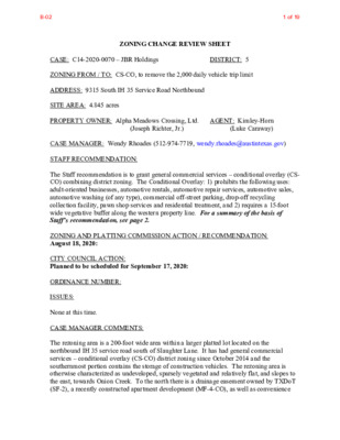
ZONING CHANGE REVIEW SHEET DISTRICT: 5 CASE: C14-2020-0070 – JBR Holdings ZONING FROM / TO: CS-CO, to remove the 2,000 daily vehicle trip limit ADDRESS: 9315 South IH 35 Service Road Northbound SITE AREA: 4.845 acres PROPERTY OWNER: Alpha Meadows Crossing, Ltd. AGENT: Kimley-Horn (Luke Caraway) (Joseph Richter, Jr.) CASE MANAGER: Wendy Rhoades (512-974-7719, wendy.rhoades@austintexas.gov) STAFF RECOMMENDATION: The Staff recommendation is to grant general commercial services – conditional overlay (CS- CO) combining district zoning. The Conditional Overlay: 1) prohibits the following uses: adult-oriented businesses, automotive rentals, automotive repair services, automotive sales, automotive washing (of any type), commercial off-street parking, drop-off recycling collection facility, pawn shop services and residential treatment, and 2) requires a 15-foot wide vegetative buffer along the western property line. For a summary of the basis of Staff’s recommendation, see page 2. ZONING AND PLATTING COMMISSION ACTION / RECOMMENDATION: August 18, 2020: CITY COUNCIL ACTION: Planned to be scheduled for September 17, 2020: ORDINANCE NUMBER: ISSUES: None at this time. CASE MANAGER COMMENTS: The rezoning area is a 200-foot wide area within a larger platted lot located on the northbound IH 35 service road south of Slaughter Lane. It has had general commercial services – conditional overlay (CS-CO) district zoning since October 2014 and the southernmost portion contains the storage of construction vehicles. The rezoning area is otherwise characterized as undeveloped, sparsely vegetated and relatively flat, and slopes to the east, towards Onion Creek. To the north there is a drainage easement owned by TXDoT (SF-2), a recently constructed apartment development (MF-4-CO), as well as convenience B-021 of 19 C14-2020-0070 Page 2 storage and equipment rental uses (CS-CO; I-RR); to the east is undeveloped property owned by the Applicant (GR-CO); and to the south is an equipment repair and sales business also owned by the Applicant (LI-CO, I-SF-2; I-RR) and a TXDOT office/warehouse facility (GO- CO). Please refer to Exhibits A (Zoning Map) and A-1 (Aerial View). The Applicant requests removal of the 2,000 daily vehicle trip limit established as a Conditional Overlay (-CO) with the 2014 rezoning ordinance as a necessary step prior to constructing site plan improvements that include an approximate 80,000 square foot general retail use. Austin Transportation Department staff recently approved a Transportation Impact Analysis (TIA) in conjunction with the site plan application. Please refer to Exhibit B (2014 Rezoning Ordinance) and Attachment A (TIA Memo). BASIS FOR RECOMMENDATION 1. The proposed zoning should be consistent with the purpose statement of the district sought. The general commercial services (CS) district is intended predominantly for commercial and industrial activities of a service nature having operating characteristics or traffic service requirements generally incompatible with residential environments. The CS district is best suited for uses located at intersections of arterial roadways or arterials with collector status. The intention is to promote safe and efficient use of transportation facilities. The Conditional Overlay (CO) combining district may be applied in combination with any base district. The district is intended to provide flexible and adaptable use or site development regulations by requiring standards tailored to individual properties. The property has access to the northbound IH 35 frontage road. 2. Zoning should promote the policy of locating retail and more intensive zoning near the intersections of arterial roadways. Staff recommends CS-CO zoning for the property based on the following considerations: 1) access is taken to a major arterial roadway; 2) compatibility with the zoning pattern and general land use character established along this segment of the IH-35 service road in proximity of East Slaughter Lane; 3) a TIA was approved in conjunction with the site plan and the removal of this component of the -CO established by zoning will eliminate a conflict between the two transportation-related restrictions; and 4) other components of the -CO that prohibit certain uses and require a vegetative buffer along the northbound IH 35 frontage road apply to similarly situated properties to the north that are developed with a convenience storage and truck rental business, and the Applicant did not propose removal or modification. EXISTING ZONING AND LAND USES: Site North ZONING CS-CO SF-2; I-RR; LAND USES Undeveloped TXDoT drainage easement; Apartments; Convenience B-022 of 19 C14-2020-0070 Page 3 MF-4-CO; CS-CO; County LI-CO; I-SF-2; I-RR; GO-CO GR-CO South East West N/A storage; Truck rental; Auto repair Equipment sales and rental; TXDoT office/warehouse facility Undeveloped (approved site plan for approximately 80,000 sf of general retail use) IH-35 Northbound service road and main lanes Bedichek Middle School SCENIC ROADWAY: No TIA: Please refer to Attachment A AREA STUDY: Not Applicable WATERSHED: Onion Creek – Suburban CAPITOL VIEW CORRIDOR: No SCHOOLS: Blazier Elementary School NEIGHBORHOOD ORGANIZATIONS: 242 – Slaughter Lane Neighborhood Association 627 – Onion Creek Homeowners Association 742 – Austin Independent School District 1228 – Sierra Club, Austin Regional Group 1258 – Del Valle Community Coalition 1408 – Go Austin Vamos Austin 78744 1363 – SEL Texas 1441 – Dove Springs Proud 1528 – Bike Austin 1530 – Friends of Austin Neighborhoods 1531 – South Austin Neighborhood Alliance (SANA) 1616 – Neighborhood Empowerment Foundation 1774 – Austin Lost and Found Pets AREA CASE HISTORIES: Crockett High School NUMBER C14-2014-0118 – NL Land Holdings, Ltd – 9101-9201 S IH 35 Service Rd NB REQUEST I-RR; CS-CO to MF-4, as amended CITY COUNCIL Approved MF-4-CO as Commission recommended (10-16-2014). COMMISSION To Grant MF-4-CO w/CO prohibiting access to Oak Hill Ln until improved to City standards, require a 15’ vegetative buffer along the west property line and 2,000 trips per day To Grant the Restrictive Covenant Termination C14-99-0132(RCT) – Prosperity Business Park – 9101-9201 S IH 35 Service Rd NB C14-2013-0009 – Prosperity Business To terminate the Restrictive Covenant Apvd as Commission recommended (8-08-2013). CS-CO to CS- CO, to change a To Grant CS-CO and remove provisions Apvd as Commission recommended B-023 of 19 C14-2020-0070 Page 4 Park – 9101-9201 S IH 35 Service Rd NB condition of zoning (8-08-2013). which limit signage and prohibit vehicular access from the property to Oak Hill Lane until this street is improved to City standards To Grant CS-CO SF-2 to CS C14-97-0081 – IH 35 South at Slaughter Lane – 9000-9100 Block of S IH 35 Service Rd NB Apvd CS-CO w/CO for 2,000 trips, list of prohibited uses, no vehicular access to Oak Hill Ln. until improved to City standards, 45’ height limit for structures, 40’ wide setback for structures from IH 35 r-o-w (10-16-1997). Apvd LI-CO w/CO for 2,000 trips per day (02-01-1996). SF-2 to LI To Grant LI-CO with conditions C14-95-0185 – Holt Company of Texas – 9601 S IH 35 Service Road NB RELATED CASES: The rezoning area was annexed into the full-purpose City limits on June 3, 1982 (C7a-80-023 – Ordinance No. 820603-P). On October 16, 2014, Council approved CS-CO zoning for the property (C14-2014-0121 – Ordinance No. 20141016-057). The property is a portion of Lot 1, Block A, Holt Cat Subdivision, recorded on February 26, 2016 (C8J-2015-0141.0A). Please refer to Exhibit C. On July 7, 2020, a site plan was administratively approved and released for a one-story general retail building (31.5 feet in height), totaling 79,484 square feet on a 15.68-acre site (SP-2019-0060C). EXISTING STREET CHARACTERISTICS: Name Classification Sidewalks ROW Pavement Bicycle Route South IH 35 511 23 feet Level 4 No Shared Capital Metro (within ¼ mile) No B-024 of 19 C14-2020-0070 Page 5 feet Lane Northbound OTHER STAFF COMMENTS: Comprehensive Planning The 4.845-acre undeveloped tract is located on the southbound service road IH 35 south of the intersection of Slaughter Land and the service road. Although it is not located within the boundaries of a City Council-adopted neighborhood plan, it is in the eastern portion of the Southpark Meadows Town Center, east of IH 35. To the northeast there is a large garden- style apartment complex. To the east is a large, undeveloped parcel that is under the same ownership. To the south is the HOLT CAT Austin heavy equipment supplier. The parcel has almost 1,200 feet of frontage along the service road. The proposed use is a 80,000 square foot home improvement store and the removal of the conditional overlay for the daily vehicle trip limit on the property. Connectivity There are no public sidewalks or bike lanes adjacent to the subject tract. All vehicular access to the site is via the one-way northbound IH 35 service road. The site is not served by transit. The nearest bus stop is approximately 0.50 miles away and is located on East Slaughter Lane adjacent to the Southpark Meadows Shopping Center on the western side of IH 35. There are no sidewalks along the service road. The subject tract also has poor roadway, pedestrian, and bicycle connectivity to most of the nearby residential uses. Imagine Austin Comprehensive Plan The subject tract falls at the far eastern portion of Southpark Meadows Town Center. Like many Imagine Austin Centers, this center is represented by a circle that reflects the general location where the center should be in the future. The center’s actual boundaries would need to be clarified through a small area planning process. Since much of the center is located west of IH 35, the subject tract has poor vehicular connections and scant bicycle or pedestrian connectivity to the center. Although the subject tract is located within the Southpark Meadows Town Center, due to the physical separation from most of the town center, it is not a part of it. Furthermore, this assessment is bolstered by the traffic circulation patterns generated by the one-way service road and the poor connectivity to nearby residential uses. The zoning request would change the zoning from / to CS-CO to remove the daily vehicle trip limit. Imagine Austin does not provide abundant policy guidance for zoning cases involving intense commercial zoning along freeway frontage roads beyond: LUT P20. Locate industry, warehousing, logistics, manufacturing, and other freight- intensive uses in proximity to adequate transportation and utility infrastructure. Based on the subject tract’s location and mobility issues, and the limited policy guidance offered by the comprehensive plan, the proposed zoning change request supports Imagine Austin. B-025 of 19 C14-2020-0070 Page 6 B-026 of 19 C14-2020-0070 Page 7 Drainage The developer is required to submit a pre- and post-development drainage analysis at the subdivision and site plan stage of the development process. The City’s Land Development Code and Drainage Criteria Manual require that the Applicant demonstrate through engineering analysis that the proposed development will have no identifiable adverse impact on surrounding properties. Impervious Cover The maximum impervious cover allowed by the CS-CO zoning district is 80%, based on the more restrictive watershed regulations. The approved site plan which includes the rezoning area and adjacent land to the east shows approximately 34.8% impervious cover. Environmental The site is not located over the Edwards Aquifer Recharge Zone. The site is in the Onion Creek Watershed of the Colorado River Basin, which is classified as a Suburban Watershed by Chapter 25-8 of the City's Land Development Code. The site is in the Desired Development Zone. Under current watershed regulations, development or redevelopment on this site will be subject to the following impervious cover limits: Development Classification % of Gross Site Area % of Gross Site Area Single-Family (minimum lot size 5750 sq. ft.) Other Single-Family or Duplex Multifamily Commercial 50% 55% 60% 80% with Transfers 60% 60% 70% 90% According to floodplain maps there is no floodplain within or adjacent to the project location. However, a critical water quality zone, as established by LDC 25-8-92, exists at the north end of the property boundary. Development within a critical water quality zone is restricted to that allowed by LDC 25-8-261. Standard landscaping and tree protection will be required in accordance with LDC 25-2 and 25-8 for all development and/or redevelopment. Under current watershed regulations, development or redevelopment requires water quality control with increased capture volume and control of the 2 year storm on site. B-027 of 19 C14-2020-0070 Page 8 Site Plan Any new development is subject to Subchapter E. Design Standards and Mixed Use. Additional comments will be made when the site plan is submitted. A retail use over 100,000 square feet and listed in 25-2-815 is a Conditional Use and will require approval by the Land Use Commission. The site is subject to compatibility standards. Along the southeast property line, the following standards apply: No structure may be built within 25 feet of the property line. No structure in excess of two stories or 30 feet in height may be constructed within 50 feet of the property line. No structure in excess of three stories or 40 feet in height may be constructed within 100 feet of the property line. No parking or driveways are allowed within 25 feet of the property line. A landscape area at least 25 feet wide is required along the property line. In addition, a fence, berm, or dense vegetation must be provided to screen adjoining properties from views of parking, mechanical equipment, storage, and refuse collection. Additional design regulations will be enforced at the time a site plan is submitted. Transportation The site is subject to the approved TIA with site plan case SP-2019-0060C. A TIA Waiver letter from a Certified Engineer (Traffic Engineer) indicating the approved trips and land uses, how many trips have been used, how many trips are left, etc, will be required with a site plan revision or correction. Additionally, provide a copy of fiscal receipts to ensure the site complies with the required mitigations. FYI – the TIA may need to be revised upon further review. Water / Wastewater FYI: The landowner intends to serve the site with City of Austin water and wastewater utilities. The landowner, at own expense, will be responsible for providing any water and wastewater utility improvements, offsite main extensions, utility relocations and or abandonments required by the land use. The water and wastewater utility plan must be reviewed and approved by Austin Water for compliance with City criteria and suitability for operation and maintenance. Depending on the development plans submitted, water and or wastewater service extension requests may be required. All water and wastewater construction must be inspected by the City of Austin. B-028 of 19 C14-2020-0070 Page 9 The landowner must pay the City inspection fee with the utility construction. The landowner must pay the tap and impact fee once the landowner makes an application for a City of Austin water and wastewater utility tap permit. INDEX OF EXHIBITS AND ATTACHMENT TO FOLLOW A: Zoning Map A-1: Aerial Map B: 2014 Rezoning ordinance C: Recorded Plat Attachment A: Transportation Impact Analysis Memo prepared for related Site Plan B-029 of 19 CONSTRUCTION\SALES/SERVICES C14-2018-0118 C14-96-0017 00-2119 COMMUN ICATION SERVICE CS-CO C14-2012-0092 ! ! C14-06-0203 ! ! ! GR-CO ! ! ! ! ! ! RETAIL ! ! CS-1 2008-0197 C14-2008-0197 ! ! ! C14-96-0015 96-0015 CARPET\RETAIL CS-CO 00-2114 AUTO TINTING/SECURITY SYS. SERV IC E\STATION SP-01-0282C 00-2089 RESTAURANT SP-04-0536C 96-0016 SP-00-2284C E V A S S E R G N O C S W SLAUGHTER LN 980326-L DENTAL\OFFICE C14-2012-0046 PET\SVCS. SLAUGHTER LN NB TO SB TRN 91-0058 FOOD SALES GR-CO GAS STATION B D S R V 5 S S IH 3 FINANCIAL\SERVICES SP- 99 -2169C 98-0125 C14-04-0037 C14-2007-0193 2007-0193 980326-L C14-04-0037 N L N E L L U C C14-05-0002 SHOPPING\CENTER 85-194 C14-03-0186 03-0066 SP-03-0283C SP-04-0318C GR-CO C14-03-0066 980326-L SP-03-0443C SP-03-0443C C14-96-0086 CS 96-0086 CS-CO C14-02-0070 02-0070 C7A-01-018 SP-00-2577D E SLAUGHTER LN UNDEV INDOOR\STORAGE C7A-01-018 I-RR C14-97-0081 CS-CO TRUCK\RENTAL SP- 97-0500C ( J U D Y D R ( ( COUNTY C14-02-0082.SH MF-3-CO AUTO REPAIR O A K H I L L L N ( TRUCKING CO. C14-02-0081 C14-2013-0053 ( C14-99-0132(RCT) C14-2013-0009 C14-99-0132 99-0132 APARTMENTS MF-4-CO C14-2014-0118 I-RR ! ! ! ! ! ! ! ! ! ! ! ! ! ! ! ! ! ! ! ! CS-1 C14-04-0203 04-0203 89-0048 T U R K LN SP-05-1166D GR-CO FURNITURE SALES C14-04-0075 99-0129 REST TAFT LN REST B N 5 3 H I S B S 5 3 H I S P M A K R R U O T B T 5 S S IH 3 P M A R B N 5 3 H I O T T D N A R B B D N R V 5 S S IH 3 ! ! ! ! ! ! ! CS-CO C14-2014-0121 ! ! ! ! ! ! ! ! ! ! ! ! ! ! ! ! ! ! ! ! ! ! C14-95-0185 LI-CO ! GR-CO C14-2018-0106 SP-05-1465D I-SF-2 EQUIPMENT\SALES E Q UIP M E N T R E P AIR I-RR ( ( ( ( ( ( ( ( ( ( ( ( ( SF-4A ( AUTO REPAIR COUNTY ( ( ( ( ( ( ( ( ( ( SF-4A ( ( ( ( M E R I D I A N O A K L N ( ( ( ( ( SF-4A ( ( ( ( ( ( ( ( ( ( ( ( ( ( ( ( ( ( ( ( ( ( ( ( ( ( ( ( ( ( ( ( C H A R L O T T E E S T A T E S D R ( ( ( ( ( ( ( ( SF-4A ( ( ( ( ( ( ( ( ( ( ( ( ( ( ( ( ( ( ( ( ( N A R R O W G L E N P K W Y ( ( ( ( ( ( ( ( ( ( ( N S L K A A O S LIS E M ( ( ( C14-02-0120A.SH ( ( ( ( ( ( SF-4A ( ( ( ( ( ( ( ( ( ( G R A N ( ( ( ( T F O R E S T D R ( ( SF-4A ( ( ( ( ( 02-0120a.SH ( ( I D L E W I L D E R U N D R ( ( ( ( ( ( ( ( ( ( ( ( ( ( ( ( ( ( ( ( ( ( ( ( ( ( ( ( ( ( ( ( ( ( ( ( GR-CO C14-2011-0012 SF-4A ( ( ( ( ( ( ( GO-CO C14-04-0204 04-0204 OFFICE/WHSE SP-01-0345D CS-CO C14-04-0094 98-0210 ± C14-04-0059 GR-CO SUBJECT TRACT ! ! ! ! ! ! PENDING CASE ZONING BOUNDARY ZONING Exhibit A ZONING CASE#: C14-2020-0070 This product is for informational purposes and may not have been prepared for or be suitable for legal, engineering, or surveying purposes. It does not represent an on-the-ground survey and represents only the approximate relative location of property boundaries. 1 " = 400 ' This product has been produced by CTM for the sole purpose of geographic reference. No warranty is made by the City of Austin regarding specific accuracy or completeness. Created: 6/29/2020 B-0210 of 19 1 3 GR-CO CS-1 1 3 5 CS-CO CS-CO 1 3 2 1 GR-CO 1 W SLAUGHTER LN 7 2 1 GR-CO 1 1 3 4 N L N E L L U C 3 4 8 B D S R V 5 S S IH 3 P M B 5 S A K R S IH 3 R U O T T P M A R B N 5 3 IH O T T D N A R B B D N R V S IH 35 S CS-CO G13 1 C14-2020-0070 GR-CO LI-CO A I-SF-2 B I-RR GO-CO 5 CS-1 7 7 T U R K LN GR-CO 6 8 9 10 T A F 11 T L N 13 B S D R V S 5 3 H I S 12 CS-CO 5 6 B S 5 3 B S IH 5 N 3 S IH B N D R V S 5 3 H I S GR-CO B 5 3 S IH D N R V S 4C CS 3 4A CS-CO E SLAUGHTER LN CS-CO 1 I-RR 2 J U D Y D R S L A U T L G O N H N S T E B B T R N R SLAUGHTER LN NB TO SB TRN B 5 S B 5 N S IH 3 S IH 3 4D 3 2 1 MF-3-CO 1B 1 15 17 14 13 O A K H I L L L N MF-4-CO 1A I-RR 1 2 3 4 5 6 7 SF-4A 8 30 29 31 33 32 34 3 2 1 37 9 10 11 16 17 18 SF-4A 19 20 21 16 19 22 23 25 24 26 27 28 8 11 22 17 12 18 20 21 16 14 15 M E R I D I A N O A K L N C H A R L O T T E E S T A T E S D R 9 SF-4A 30 28 31 6 33 34 26 25 28 27 4 35 36 30 29 2 23 23 21 13 24 25 26 32 5 7 24 6 7 3 4 5 15 16 14 12 13 14 19 18 17 16 15 A N S S L LIS K E A M 14 O 13 19 11 17 12 22 10 8 9 N A R R O W G L E N P K W Y 20 SF-4A 11 10 9 8 1 28 1 2 3 4 26 25 24 27 5 7 6 12 I D L E W I L D E R U N D R 45 46 42 41 43 SF-4A 44 51 47 48 49 50 23 22 21 20 2 3 4 5 6 7 19 18 17 16 39 38 31 32 36 37 35 34 33 29 O U T W O O D 58 M I L L L N 57 56 Copyright nearmap 2015 54 6 7 27 53 28 55 26 23 24 25 24 19 20 21 22 23 GR-CO 14 ± 1'' = 400' JBR HOLDINGS Exhibit A - 1 SUBJECT TRACT ZONING BOUNDARY ! ! ! ! ! ! PENDING CASE CREEK BUFFER ZONING CASE#: LOCATION: SUBJECT AREA: GRID: MANAGER: C14-2020-0070 9315 IH 35 SR NB 4.845 Acres G13 Wendy Rhoades This map has been produced by the Communications Technology Management Dept. on behalf of the Planning Development Review Dept. for the sole purpose of geographic reference. No warranty is made by the City of Austin regarding specific accuracy or completeness. B-0211 of 19 B-0212 of 19 B-0213 of 19 B-0214 of 19 B-0215 of 19 MEMORANDUM Date: To: CC: Reference: January 15, 2020 Robert Anderson, Case Manager Santiago Araque, P.E. Curtis Beatty, P.E. Amber Mitchell Joan Jenkins, EIT JBR Holdings – TIA Final Memo (SP-2019-0060C) Summary of the Transportation Impact Analysis (TIA): The Austin Transportation Department (ATD) has reviewed the December 4, 2019 (received December 5, 2019) “JBR TIA”, prepared by Kimley-Horn. The proposed land uses consist of 4,000 SF of shopping center, 80,000 SF of home improvement superstore, 12,000 SF of high-turnover (sit-down) restaurant, and 2,500 SF of coffee/donut shop with drive- thru. The development will be located south of Oak Hill Lane on the east side of the IH-35 northbound frontage road (NBFR), in south Austin, and is anticipated to be completed by 2020. The following is a summary of the review findings and recommendations: 1. A Fee-in-lieu contribution to the City of Austin shall be made for the improvements identified in Table 2, totaling $37,250. Of that $37,250 total, $14,155 shall be paid to the City of Austin before the site development permit is issued. Please see attached invoice (Exhibit A). 2. The remaining $23,095 fee in-lieu shall be paid with the associated zoning case to remove the conditional overlay. 3. Development of this property should not vary from the approved uses or deviate from the approved intensities and estimated traffic generation assumptions within the finalized TIA document, including land uses, trip generation, trip distribution, traffic controls, driveway locations, and other identified conditions. Any change in the assumptions made to the TIA document shall be reviewed by ATD and may require a new or updated TIA/addendum. 4. Two copies of the final TIA are required to be provided prior to the issuance of any site development permit. One should be delivered to ATD and one to DSD. 5. City staff reserves the right to reassign any or all the above monies to one or more of the identified improvements. Attachment A Page 1 of 4 B-0216 of 19 6. The findings and recommendations of this TIA memorandum remain valid until five (5) years from the date of this memo, after which a revised TIA or addendum may be required. Site Location and Existing Conditions: The development is intending to use two proposed driveways for site access. Both driveways take access to IH-35 NBFR, will require deceleration lanes, and will need to be approved by TxDOT. Assumptions: 1. The following reductions were applied for this development: Internal Capture (10% AM & PM) 2. Based on TxDOT AADT volume data, a two and one-half (2.5) percent annual growth rate was assumed to account for the increase in background traffic. 3. Below are the background projects that were assumed to contribute trips to surrounding roadway network in addition to forecasted traffic for 2020: South by South Congress Foremost Multi-Family Development Proposed Conditions: Trip Generation and Land Use Based on the Institute of Transportation Engineers (ITE) Trip Generation Manual (10th Edition), the development would generate approximately 6,534 average daily trips (ADT) upon final build-out. Table 1, below, shows the trip generation by land uses for the proposed development. Proposed Land Use (ITE Code) Size 24-Hour Two Way Volume AM Peak Hour PM Peak Hour Enter Exit Enter Exit Shopping Center (820) Home Improvement Superstore (862) High-Turnover (Sit- Down) Restaurant (932) Coffee/Donut Shop with Drive-thru (937) Total 4,000 SF 674 80,000 SF 2,460 12,000 SF 1,348 2 72 65 2 54 54 24 91 73 26 95 44 2,500 SF 2,052 113 109 54 54 6,534 252 219 242 219 Page 2 of 4 B-0217 of 19 Summary of Recommended Improvements As mitigation for this development, it is recommended that the applicant contribute a total of $37,250 in fee in-lieu towards improvements identified at the IH-35/Slaughter Lane interchange in the Slaughter Lane Corridor Improvement Plan. Due to a conditional overlay over a portion of the property, it is recommended that this payment be split into two phases to ensure that the fee is being assessed fairly. The fee in- lieu portion associated with the site plan is based on the daily trips from the home improvement superstore land use, as this land use is the only one allowed at this time given the conditional overlay. The home improvement superstore daily trips comprise 38% of the total daily trips, therefore a partial fee in-lieu payment of $14,155 is being requested at the time of site plan. The remaining $23,095 fee in-lieu payment shall be required with the associated zoning case to remove the conditional overlay. Table 2: Recommended Improvements and Developer’s Share Intersection Improvement Cost IH-35/Slaughter Lane Interchange IH-35/Slaughter Lane Interchange Corridor Improvements Corridor Improvements Pro-Rata Share % Pro-Rata Share $ $14,155 fee in-lieu payment to City as part of this site plan application $23,095 fee in-lieu payment to City as part of the zoning case to remove the conditional overlay Total $37,250 If you have any questions or require additional information, please feel free to contact me at 512-974-1449. Justin Good, P.E. Austin Transportation Department Page 3 of 4 B-0218 of 19 EXIBIT A INVOICE TRANSPORTATION MITIGATION FEE IN-LIEU DATE: January 15, 2020 TO: CC: Santiago Araque (Kimley-Horn) Alyssa Gutierrez (ATD Cashier) 901 S. Mopac Expressway, Bldg 5, Suite 300, Austin TX 78746 FROM: Justin Good, P.E. Austin Transportation Department AMANDA CASE#: SP-2019-0060C (JBR Holdings) FDU: 8401-2507-1103-4163 As a condition of approval for the site development permit, the applicant shall post a transportation mitigation fee with the City of Austin in the amount of $14,155.00 as listed in the TIA Final Memo in accordance with LDC. Staff has reviewed the fiscal estimates dated January 15, 2020, provided by Santiago Araque of Kimley-Horn. If you have any questions, please contact me at (512) 974-1449. Office Use only: Check: Received by: Page 4 of 4 B-0219 of 19