B-05 (C814-2018-0122 (Circuit of the Americas PUD Zoning Case Report) Part 3.pdf — original pdf
Backup
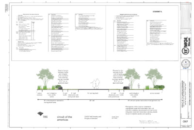
. B T C B E H - D R B : E L Y T S T O L P : M A 8 2 8 0 2 0 2 7 7 / / : N O D E T T O L P I S N B B E T S N O S L A I : Y B D E T T O L P . 3 C P F D P O T G W D : I H T W D E T T O L P . I K C R Y W A S S R A M I : I I Y B D E F D O M T S A L : M A 9 1 2 1 0 2 0 2 5 5 / / : I I N O D E F D O M T S A L 5 4 3 2 1 s l i l a t e D g n i t n a P T U O Y A L - g w d . t e e h S s l i a t e D n i t n a P l - 1 0 0 . 0 5 . 6 4 9 0 \ l a t t i m b u S r o i i f s n o s v e R n a P D U P \ s t i l i b h x E - 6 0 \ l i i v C - 1 0 \ i n o s n a p x E s a c i r e m A e h t f o t i u c r i C - 1 0 0 . 0 5 \ s a c i r e m A e h t f o t i u c r i C - 6 4 9 0 \ s t c e o r P j \ : P : E M A N E L F I G F E D C B A EXHIBIT L G F E D C B A Y B I I N O T P R C S E D E T A D . O N 2 0 7 8 7 , S A X E T , I N T S U A 0 0 2 E T U S I , T E E R T S H T 5 T S A E 1 2 0 2 5 8 0 5 1 - F : O N M R F I 0 6 5 5 . 9 6 6 . 2 1 5 N O I S N A P X E S A C I R E M A E H T F O T I U C R I C I D R A V E L U O B S A C R E M A E H T F O T U C R C 1 0 2 9 I I 7 1 6 8 7 S A X E T , Y T N U O C S V A R T I , I N T S U A S L I A T E D G N I T N A L P N O I T A R O T S E R : T C E J O R P : I E L T T T E E H S C007 ---- OF 10 C814-2018-0122 1 of 41 EXHIBIT M 2 of 41 3 of 41 4 of 41 5 of 41 6 of 41 EXHIBIT N 7 of 41 8 of 41 9 of 41 Carbon Impact Statement EXHIBIT O Project: Scoring Guide: 1-4: Business as usual 5-8: Some positive actions 9-12: Demonstrated leadership 1 2 3 4 5 6 7 8 9 10 11 12 Response: Y=1, N=0 Documentation: Y/N Transportation T1: Public Transit Connectivity T2: Bicycle Infrastructure T3: Walkability T4: Utilize TDM Strategies T5: Electric Vehicle Charging T6: Maximize Parking Reductions Water + Energy WE1: Onsite Renewable Energy WE2: Reclaimed Water Land Use LU1: Imagine Austin Activity Center or Corridor LU2: Floor-to-Area Ratio Food F1: Access to Food Materials M1: Adaptive Reuse Total Score: The Carbon Impact Statement calculation is a good indicator of how your individual buildings will perform in the Site Category of your Austin Energy Green Building rating. Notes: Brief description of project, further explanation of score and what it means 010000001111NNNNNNYYYYYN10 of 41 T1. Is any functional entry of the project within 1/4 mile walking distance of existing or planned bus stop(s) serving at least two bus routes, or within 1/2 mile walking distance of existing or planned bus rapid transit stop(s), or rail station(s)? T2. Is there safe connectivity from the project site to an “all ages and abilities bicycle facility” as listed in the Austin Bicycle Master Plan? T3. Is the property location “very walkable” with a minimum Walk Score of 70 (found at walkscore.com), or will the project include at least five new distinct basic services (such as a bank, restaurant, fitness center, retail store, daycare, or supermarket)? T4. Does the project utilize two or more of the following Transportation Demand Management strategies: unbundling parking costs from cost of housing/office space, providing shower facilities, providing secured and covered bicycle storage, and/or providing 2+ car sharing parking spaces for City-approved car share programs? T5. Will the project include at least one DC Fast Charging electric vehicle charging station? T6. Does the project utilize existing parking reductions in code to provide 20% less than the minimum number of parking spaces required under the current land development code (or 60% less than the code’s base ratios if there is no minimum parking capacity requirement)? WE1. Will the project include on-site renewable energy generation to offset at least 1% of building electricity consumption? WE2. Will the project include one or more of the following reclaimed water systems: large scale cisterns, onsite grey or blackwater treatment, and reuse or utilization of Austin Water Utility's auxiliary water system to eliminate the use of potable water on landscape/irrigation? LU1. Is the proposed project site located within one of the centers or corridors as defined in the Imagine Austin Comprehensive Plan Growth Concept Map? LU2. If located in an Imagine Austin activity center or corridor, will the proposed project use at least 90% of its entitled amount of floor-to-area ratio? F1. Will the project include a full service grocery store onsite, or is one located within 1 mile of the project, or will the project integrate opportunities for agriculture to the scale as defined by Austin Energy Green Building? M1. Will the project reuse or deconstruct existing buildings on the project site? 11 of 41 EXHIBIT P MEMORAN DUM Date: To: CC: June 19, 2020 Sherri Sirwaitis, Case Manager Dan Hennessey, P.E., WGI; Curtis Beaty, P.E., ATD; Joan Jenkins EIT, ATD; Amber Mitchell, ATD Reference: Circuit of the Americas PUD Transportation Impact Analysis Final Memo C814-2018-0122 Summary of the Transportation Impact Analysis (TIA): The Austin Transportation Department (ATD) has thoroughly reviewed the “Circuit of the Americas Expansion” TIA dated June 18, 2020, prepared by WGI. Note that for this particular case, specific sections of the TIA were submitted for early review as they became available due to the significant extent of the analysis. ATD then reviewed the final TIA to ensure consistency with the previously approved sections. The proposed development includes a 358-room hotel, a 150-room hotel, water slide park with 416 parking spaces, soccer complex with 11 fields, 30 dwelling units of recreational homes, 150,000 SF of general office, 50,000 SF of shopping center, 120,000 SF of general light industrial, 70,000 SF of museum, a 170,000 SF indoor sports facility, and a 20,000 SF e-sports arena. This development is located in southeast Austin on Circuit of the Americas Boulevard between FM 812 and Elroy Road. The development is anticipated to be completed in two phases with build-out years of 2021 and 2026 for Phase 1 and Phase 2, respectively. Below is a summary of our review findings and recommendations: 1. The applicant shall design, construct, and fund 100% of the improvements identified in Table 2 as part of their first site development application for Phase 1. No temporary certificate of occupancy (TCO) or certificate of occupancy (CO) shall be issued until the construction of the identified improvements is complete. Note: Cost estimates should not be assumed to represent the maximum dollar value of improvements the applicant may be required to construct. 2. The applicant shall also design, construct, and fund 100% of the improvements identified in Table 3, excluding the Kellam Road widening project, as part of their site development applications for Phase 2. Off-site improvements shall be included in the first site plan for each identified Planning Area based on the Planning Areas Map shown in Attachment B. No temporary certificate of occupancy (TCO) or certificate of occupancy (CO) shall be issued until the construction of the identified improvements is complete. Note: Cost estimates should not be assumed to represent the maximum dollar value of improvements the applicant may be required to construct. Page 1 of 13 12 of 41 3. If at the time of site plan it is determined by the Authority (government entity corresponding to the specific improvements) that the triggered improvements are already constructed or if other improvements noted in the TIA are deemed higher priority, then a fee-in-lieu payment for the estimated cost of the triggered improvements shall be made to the respective government entity. 4. The applicant shall contribute a fee-in-lieu payment to Travis County for the construction of an additional southbound through lane on Kellam Road between Pearce Lane and Elroy Road for each site plan application in Phase 2. The fee-in-lieu amount shall be determined by calculating the percentage of unadjusted site trips versus the most recent estimate of total trips to be generated by all Phase 2 land uses and applying that percentage to the estimated improvement cost of $2,727,273. Note that the current edition of the ITE Trip Generation Manual at time of site plan shall be used to calculate the unadjusted site trips. 5. Development of this property should not vary from the approved uses or deviate from the approved intensities and estimated traffic generation assumptions within the finalized TIA document, including land uses, trip generation, trip distribution, traffic controls, driveway locations, and other identified conditions. Any change in the assumptions made to the TIA document shall be reviewed by ATD and may require a new or updated TIA/addendum. 6. The applicant shall provide an electronic copy of the final TIA report, including all supplemental documents, before 3rd reading. 7. The findings and recommendations of this TIA memorandum remain valid until the end of the Phase 2 buildout year, December 31, 2026, after which a revised TIA or addendum may be required. Assumptions 1. The development will consist of two phases with build-out years of 2021 and 2026 for Phase 1 and Phase 2, respectively. 2. Based on TxDOT AADT volume data, a five (5) percent annual growth rate was assumed to account for the increase in background traffic. 3. Below are the background projects that were assumed to contribute trips to the surrounding roadway network in addition to forecasted traffic for 2021 and 2026: Lexington Parke Elroy Retail Trip Generation and Land Use Based on the Institute of Transportation Engineers (ITE) Trip Generation Manual (10th Edition) and trip generation studies for the indoor sports facility and e-sports arena, the development will generate approximately 15,342 unadjusted average daily vehicles trips (ADT) at full build out as shown in Table 1. Page 2 of 13 13 of 41 Table 1 – Trip Generation Size 24-Hour Two Way Volume AM Peak Hour Enter Exit PM Peak Hour Enter Exit Proposed Land Use (ITE Code) Phase 1 Land Uses Hotel (310) Water Slide Park (416) 358 Rooms 416 Parking Spaces General Office (710) 150 kSF Subtotal Phase 2 Land Uses Soccer Complex (488) Hotel (310) Recreational Homes (260) Shopping Center (820) General Light Industrial (110) Museum (580) Indoor Sports Facility (Custom Rate) E-Sports Arena (Custom Rate) 11 Fields 150 Rooms 30 DU 50 kSF 120 kSF 70 kSF 2,993 944 3,937 785 1,254 104 1,572 3,752 513 130 69 10 79 4 29 2 23 67 6 3 2 99 23 122 7 42 5 144 110 45 17 1 556 678 110 24 134 119 46 3 27 156 5 2 16 581 715 105 92 197 62 44 5 140 169 37 11 3 593 790 170 kSF 3,107 185 68 207 122 20 kSF 188 Subtotal Total 11,405 15,342 204 283 Summary of Recommended Improvements Mitigation for this development has been split between the two proposed phases. Specific improvements were identified for each phase in the TIA report to accurately assess the timing and priority of said improvements. Phase 1 is identified as including the 358-room hotel and water park. Improvements associated with Phase 1 are to be shown on the first site plan application and constructed before the TCO or CO is issued. Table 2 below summarizes the improvements associated with Phase 1. For Phase 2, a mitigation phasing agreement was established to ensure that improvements are being constructed proportional to the level of development activity occurring. Identified improvements for Phase 2 have been tied to specific development Planning Areas based on the Planning Areas Map shown in Attachment B. A TIA Waiver Letter will be required with all site plan applications to determine which improvements, if any, are triggered and ensure the development continues to comply with the requirements of this TIA memo. For the first site plan application associated with each Planning Area, all improvements tied to that Planning Area, as listed in Table 3, shall be shown on the site plan application and Page 3 of 13 14 of 41 constructed before the TCO or CO is issued. Note that the land uses from Phase 1 do not count towards triggering improvements from Phase 2. For all site plan applications in Phase 2, a fee-in-lieu payment to Travis County shall be required for the construction of a southbound through lane on Kellam Road from Pearce Lane to Elroy Road. This fee-in-lieu amount will be assessed based on the percentage of unadjusted site trips versus the most recent estimate for the total trips to be generated by all Phase 2 land uses. Note that the current edition of the ITE Trip Generation Manual at time of site plan shall be used to calculate the unadjusted site trips. Information regarding the fee-in-lieu amount shall be included in the TIA Waiver Letters mentioned above. Table 2 – Phase 1 Improvements Intersection Improvement Estimated Cost Improvement Trigger First site plan in Phase 1 First site plan in Phase 1 First site plan in Phase 1 First site plan in Phase 1 $250,000 $12,500 $102,272 $102,272 $102,272 First site plan in Phase 1 $68,182 First site plan in Phase 1 First site plan in Phase 1 First site plan in Phase 1 $250,000 $85,227 First site plan in Phase 1 Elroy Road & Circuit of the Americas Boulevard / Kellam Road Pearce Lane & Kellam Road Design and construct a traffic signal Restripe the northbound Circuit of the Americas Boulevard approach to provide dual left-turn lanes Design and construct a dedicated eastbound right-turn lane on Elroy Road (300-ft storage) Design and construct a dedicated eastbound left-turn lane on Pearce Lane (300-ft storage) Design and construct a dedicated westbound left-turn lane on Pearce Lane (300-ft storage) Design and construct a dedicated westbound right-turn lane on Pearce Lane (200-ft storage) Modify signal equipment $25,000 FM 812 & Circuit of the Americas Boulevard FM 973 (Clinger Road) & FM 812 Design and construct a traffic signal Design and construct a dedicated eastbound right-turn lane on FM 973 (Clinger Road) (250-ft storage) Total $997,725 Note: No temporary certificate of occupancy (TCO) or certificate of occupancy (CO) shall be issued until the construction of the identified improvements is complete. Page 4 of 13 15 of 41 Table 3 – Phase 2 Improvements Planning Area Intersection Improvement Improvement (Construction) N/A N/A N/A N/A N/A N/A FM 973 (Clinger Road) & FM 812 Pearce Lane & Wolf Lane Design and construct a traffic signal Design and construct a traffic signal Pearce Lane & Ross Road FM 812 & SH 130 Frontage Roads FM 812 & Elroy Road Design and construct a dedicated eastbound left-turn lane on Pearce Lane (500-ft storage) and modify signal equipment Design and construct traffic signals at both frontage road intersections Design and construct a traffic signal 1 2 3 4 5 6 7 8 Estimated Improvement Cost N/A Trigger N/A $250,000 First site plan $250,000 First site plan $200,000 First site plan $350,000 First site plan $250,000 First site plan Improvement (Fee-In-Lieu) Design and construct an additional southbound through lane from Pearce Lane to Elroy Road Total estimated cost: $2,727,273 Each site plan, regardless of Planning Area, shall contribute a fee-in-lieu payment to Travis County based on the percentage of unadjusted site trips versus the most recent estimate of total trips to be generated by all Phase 2 land uses. The current edition of the ITE Trip Generation Manual at time of site plan shall be used to calculate unadjusted site trips $2,727,273 N/A N/A N/A N/A Total $1,300,000 Note: For each site plan in Phase 2, no temporary certificate of occupancy (TCO) or certificate of occupancy (CO) shall be issued until the construction of the identified improvements is complete and the appropriate fee-in-lieu amount is paid. Again, it should be noted that the applicant shall design and construct all the improvements (except the road widening improvement to Kellam Road) noted in Table 2 and Table 3 above with the funding solely from the applicant. For the roadway widening improvement to Kellam Road, the applicant shall contribute fee-in-lieu mitigation payments to Travis County for every site plan application associated with Phase 2. The cost estimates noted in the tables above are planning level cost estimates for the purpose of discussion and review only. The cost estimates noted in the tables shall not be assumed to represent the maximum dollar value of improvements the applicant is required to construct. If you have any questions or require additional information, please contact me at 512-974- 1449. Justin Good, P.E. Austin Transportation Department Page 5 of 13 16 of 41 EXHIBIT A SITE LOCATION MAP Page 6 of 13 17 of 41 FigureStudy Area12345678910111213141516171819202122Key Study IntersectionXProject Site18 of 41 EXHIBIT B PLANNING AREAS MAP Page 8 of 13 19 of 41 FigureCOTA Planning Areas Map83276514Elroy RoadFM 812Kellam RoadMcAngus RoadBurkland Farms RoadElroy Road20 of 41 EXHIBIT C IMPROVEMENTS MAP – PHASE 1 Page 10 of 13 21 of 41 FigurePhase 1 (2021) Improvements1619Key Study IntersectionXProject SiteFM 973 (Clinger Road) / FM 812: Add Dedicated EBR Turn Lane (250' Storage)FM 812 / COTA Boulevard:Signalization149Pearce Lane / Kellam Road: Add Dedicated EBL Turn Lane (300' Storage)Add Dedicated WBL Turn Lane (300' Storage)Add Dedicated WBR Turn Lane (200' Storage)Modify Signal EquipmentElroy Road / COTA Boulevard / Kellam Road: SignalizationRe-Stripe NB ApproachAdd Dedicated EBR Turn Lane (300' Storage)22 of 41 EXHIBIT D IMPROVEMENTS MAP – PHASE 2 Page 12 of 13 23 of 41 FigurePhase 2 (2026) Improvements81016171822Key Study IntersectionXProject SiteFM 973 (Clinger Road) / FM 812:SignalizationFM 812 / TX-130 Frontage Roads:SignalizationElroy Road / FM 812: SignalizationPearce Lane / Ross Road:Add Dedicated EBL Turn Lane (500' Storage)Modify Signal EquipmentPearce Lane / Wolf Lane: SignalizationKellam Road:Add Southbound Lane from Pearce Lane to Elroy Road24 of 41 EXHIBIT Q ITEM FOR ENVIRONMENTAL COMMISSION MEETING DATE: July 15, 2020 NAME & NUMBER OF PROJECT: PUD: Circuit of the Americas (COTA) C814-2018-0122 NAME OF APPLICANT OR ORGANIZATION: Michele Rogerson-Lynch LOCATION: 9201Circuit of the Americas COUNCIL DISTRICT: 2 WATERSHED: Dry Creek East and Maha Creek REQUEST: To create a Planned Unit Development (PUD) STAFF RECOMMENDATION: RECOMMENDED CONDITIONS: Staff recommended with conditions 1. Water quality for all new development shall consist of 100% green storm water infrastructure 2. Impervious cover limited to 68% 3. Dedicate 11.38 gross acres of parkland 4. Provide 298 acres of Open Space 5. Restore 14.36 acres of wetlands 6. Re-permit and construct US Army Corps of Engineers creek restoration 7. Install 400 native trees minimum size 2" caliper and water trees for establishment. Trees shall not count towards any other landscape requirement 8. Provide .88 acres of water quality treatment to mitigate asphalt trail 9. Restore vegetation along asphalt trail per Sheet 9 10. Requirements outlined in conditions #5, #6, #7, #8, and #9 shall be constructed with the first site plan requiring a building permit and only a site plan for the recreation fields associated with PA 4 shall proceed these requirements 25 of 41 ENVIRONMENTAL COMMISSION MOTION 20200715-003a Date: July 15, 2020 RATIONALE: Subject: Circuit of the Americas (COTA) Planned Unit Development, C814-2018-0122 Motion by: Kevin Ramberg Seconded by: Mary Ann Neely WHEREAS, the Environmental Commission recognizes the applicant wishes to create a Planned Unit Development (PUD) on the 1,153-acre site at 9201 Circuit of the Americas Boulevard. WHEREAS, the Environmental Commission recognizes that staff recommends the approval of the PUD with recommendations. THEREFORE, the Environmental Commission recommends the creation of the COTA PUD with the following; Impervious cover limited to 68%; Staff Conditions 1. Water quality for all new development shall consist of 100% green storm water infrastructure; 2. 3. Dedicate 11.38 gross acres of parkland; 4. Provide 298 acres of Open Space; 5. Restore 14.36 acres of wetlands; 6. Re-permit and construct US Army Corps of Engineers creek restoration; 7. Install 400 native trees minimum size 2" caliper and water trees for establishment. Trees shall not count towards any other landscape requirement; 8. Provide 0.88 acre of water quality treatment to mitigate asphalt trail; 9. Restore vegetation along asphalt trail per Exhibit L; and, 10. Requirements outlined in conditions #5, #6, #7, #8, and #9 shall be constructed with the first site plan requiring a building permit and only a site plan for the recreation fields associated with PA 4 shall proceed these requirements. Environmental Commission Conditions: 1. Applicant will hire a certified arborist to oversee the maintenance of (i.e. plan for watering, pruning, mulching, etc.) the planted trees for three years. 1 26 of 41 For: Bedford, Creel, Smith, Thompson, Nill, Neely, Coyne, Maceo, Ramberg, Guerrero, and Gordon Against: None Abstain: None Recuse: None Absent: None VOTE 11-0 Approved By: Linda Guerrero, Environmental Commission Chair 2 27 of 41 Circuit of the Americas (COTA) C814-2018-0122 Atha Phillips, Environmental Program Coordinator Environmental Officer’s Office 28 of 41 Downtown Austin Site Location Austin ETJ Austin City Limits Edwards Aquifer Recharge Zone Edwards Aquifer Contributing Zone North 29 of 41 HWY 71 ABIA Site Location North 30 of 41 Site Location North 31 of 41 Site Data: • 1153 acres • Full-Purpose Jurisdiction • Watersheds: Dry Creek East and Maha Creek • Council District: 2 32 of 41 Critical Water Quality Zone Wetlands (typical) 33 of 41 100-year Floodplain 34 of 41 Project History: • Resolution 201120629-002: Allowed the City Manager to negotiate and execute an agreement with Circuit of the Americas • On July 31, 2011, the City entered into an agreement with Circuit of the Americas • The agreement had several requirements that have been tracked by the Economic Development Department. Some of the requirements include: • Air quality and emissions standards • Recycling program • Transportation management strategies • Renewable energy requirements • Land preservation and restoration • Locate a 5-acre community garden • Follow Environmental Board recommendations • Plant at least 800 trees • Protect existing wetlands and critical environmental features • Buildings shall meet AEGB 2-star rating or LEED Silver 35 of 41 Environmental Board recommendations: Comply with commercial landscape standards Comply with parking lot shading requirements Investigate the restoration of riparian of Dry Creek Demonstrate a black land prairie land restoration Perform restoration of Dry Creek Riparian Corridor and Blackland Prairie Corridor, by working with partners such as Texas A & M. Establish a monitoring program of any pervious pavement used on site N/A 36 of 41 Comparison: Water Quality 100% capture volume or payment in lieu 100% capture volume 100% Green Stormwater Infrastructure Existing Code/Agreement/Site plan Proposed PUD Drainage No adverse impact No adverse impact Impervious Cover 80% 68% Open Space 20% of non-residential tracts (Tier 1) Additional 20% (Tier 2) 273 acres Total: 23.6% Required as part of agreement. Will provide Integrated Pest Management Green Building 2-Star Certified 2-Star Certified Parkland Dedication 7.81 acres 11.38 acres and constructing soccer fields Cut and Fill 4’-8’ Administrative variance 8+ Land Use variance Certain capped amounts in PA 4 Critical Environmental Features Protect wetlands with buffer or provide mitigation. Protect existing features and provide additional 14.36 acres of mitigation 37 of 41 Comparison: Landscape Trees CWQZ Existing Code/Agreement/Site plan Proposed PUD Current code Current code Current code including Heritage Tree ordinance Current code including Heritage Tree ordinance 50’-300’ buffer depending on drainage and 100-year floodplain Current code CWQZ crossing Allowed 30’ decomposed granite trail with approved site plan Permit asphalt trail 38 of 41 39 of 41 Code Modifications: 25-8-262: Critical Water Quality Zone Street Crossings- To allow an existing asphalt trail to remain within the critical water quality zone. 25-8-341: To allow a specified amount of cut above 4’ within PA4. Cut 75,600 square feet 86,100 square feet 25-8-342: To allow a specified amount of fill above 4’ within PA4. Fill 121,800 square feet 52,500 square feet 4-8’ 8-14’ 4-8’ 8-20’ 40 of 41 Recommended with Conditions: 1. Water quality for all new development shall consist of 100%green storm water infrastructure Impervious cover limited to 68% 2. 3. Dedicate 11.38 gross acres of parkland 4. Provide 298 acres of Open Space 5. Restore 14.36 acres of wetlands 6. Re-permit and construct US Army Corps of Engineers creek 7. restoration Install 400 native trees minimum size 2" caliper and water trees for establishment. Trees shall not count towards any other landscape requirement 8. Provide .88 acres of water quality treatment to mitigate asphalt trail 9. Restore vegetation along asphalt trail per Sheet 9 10. Requirements outlined in conditions #5, #6, #7, #8, and #9 shall be constructed with the first site plan requiring a building permit and only a site plan for the recreation fields associated with PA 4 shall proceed these requirements. 41 of 41