B-03 (C14-2020-0054 - Naples; District 6) — original pdf
Backup
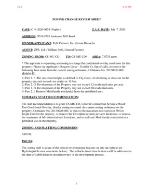
ZONING CHANGE REVIEW SHEET CASE: C14-2020-0054 (Naples) Z.A.P. DATE: July 7, 2020 ADDRESS: 9710-9718 Anderson Mill Road OWNER/APPLICANT: Pohl Partners, Inc. (Jennie Braasch) AGENT: ZFB, Ltd. (William Pohl, General Partner) ZONING FROM: CS-MU-CO TO: CS-MU-CO* AREA: 7.8733 acres * The applicant is requesting a rezoning to change the conditional overlay conditions for this property (Please see Applicant’s Request Letter – Exhibit C). Specifically, to remove the following four items from the current zoning ordinance, Ordinance No. 20130620-080 (Exhibit D). 1) Part 2. F. The maximum height, as defined in City Code, of a building or structure on the property may not exceed two stories or 30 feet. 2) Part 2. G. Development of the Property may not exceed 12 residential units per acre. 3) Part 2. H. Development of the Property may not exceed 60 residential units. 4) Part 2. I. Remove Multifamily residential from the prohibited uses. SUMMARY STAFF RECOMMENDATION: The staff recommendation is to grant CS-MU-CO, General Commercial Services-Mixed Use-Conditional Overlay, district zoning to amend the current zoning ordinance on the property, Ordinance No. 20130620-080, to remove the maximum two stories or 30 feet height limit for the property, to remove the 12 residential units per acre limitation, to remove the maximum of 60 residential unit limitation, and to add back Multifamily residential as a permitted use on the property. ZONING AND PLATTING COMMISSION: 7/07/20: ISSUES: The zoning staff is aware of the critical environmental features on this site (please see Hydrologist Review comments below). The setbacks from these features will be addressed at the time of subdivision or site plan review in the development process. 1 1 of 26B-3 DEPARTMENT COMMENTS: This property was annexed into the full purpose jurisdiction of the City of Austin on December 31, 2008, under annexation case C7A-08-009. A proposed site plan (SPC-2008- 0090D) for a convenience storage use was filed more than 90 days before the annexation, thereby establishing a Continuation of Land Use pursuant to the Texas Local Government Code § 43.002: (a) A municipality may not, after annexing an area, prohibit a person from: (1) continuing to use land in the area in the manner in which the land was being used on the date the annexation proceedings were instituted if the land use was legal at that time; or (2) beginning to use land in the area in the manner that was planned for the land before the 90th day before the effective date of the annexation if: (A) one or more licenses, certificates, permits, approvals, or other forms of authorization by a governmental entity were required by law for the planned land use; and (B) a completed application for the initial authorization was filed with the governmental entity before the date the annexation proceedings were instituted. Because the site plan was filed within the appropriate timeframe before annexation, the existing uses were determined on the property and considered grandfathered. Therefore, in the initial zoning case, C14-2008-0234, the staff recommended the continuation of these uses under the CS district for this site. The staff also recommended a conditional overlay that prohibited any uses allowed in the CS zoning district other than the current established use and recommended permitting uses allowed in the LO zoning district that are also permitted in CS district zoning (see below). In this case, the staff recommends and the “MU” mixed use combining district to the “CS” zoning while continuing the existing conditional overlay for this property. Thereby permitting the following uses on this site: Convenience Storage Bed & Breakfast (Group 1) Bed & Breakfast (Group 2) Condominium Residential Duplex Residential Group Residential Multifamily Residential Single-Family Attached Residential Single-Family Residential Small Lot Single-Family Residential Townhouse Residential Two-Family Residential Short-Term Rental Administrative and Business Offices Art Gallery Art Workshop 2 2 of 26B-3 Communication Services Medical Offices (exceeding 5000 sq. ft.) Medical Offices (not exceeding 5000 sq. ft.) Professional Office Software Development Communications Service Facilities Counseling Services Cultural Services Day Care Services (Limited, General, Commercial) Family Home Group Home, Class I (Limited, General) Local Utility Services Private Primary Educational Facilities Public Primary Educational Facilities Public Secondary Educational Facilities Religious Assembly Safety Services During the previous zoning case C14-2013-0012, the staff was supportive of the applicant’s request to add the Mixed Use Combining District to the existing zoning because the addition of the ability to develop residential uses to the site allowed for less intensive development on the property adjacent to a single-family residential neighborhood to the north, a day care facility to the east and a religious assembly use to the west. Therefore, the staff is supportive of the applicant’s current request to amend the zoning ordinance for this property, Ordinance 20130620-080, to remove the maximum two stories or 30 feet height limit for the property, to remove the 12 residential units per acre limitation, to remove the maximum of 60 residential units limitation, and to add back Multifamily residential as a permitted use on the property. This request is reasonable given the property’s location/frontage on a major retail corridor/arterial roadway, Anderson Mill Road, and the surrounding residential (SF-2), office (LO, LO-CO) and commercial (LR-CO, GR) uses and zoning. The proposed amendment to the existing conditional overlay will permit the applicant to develop multifamily residential units at this location which will provide for additional housing opportunities in this area of the city. The applicant agrees with the staff’s recommendation. 3 3 of 26B-3 EXISTING ZONING AND LAND USES: Site North South ZONING CS-MU-CO SF-2 LO, LR-CO, SF-6, East I-RR, LO-CO, DR West I-RR, LO-CO LAND USES Undeveloped Area, Barn Single-Family Residential Neighborhood (Acres West) Office (Oak Park Office Center), Banu TV Repair, Retail Center (Arboretum Park: Trillium Montessori, One on One Physical Therapy, Homecare Assistance, Korey Howell Photography, Salon, Republic Spine & Pain, Farmers Insurance, Tender Laser Care, Vital Sleep), Condominiums (Arboretum Park Cottages) Billboard, Service Station (Valero), Day Care Facility (Xplorer), Funeral Home (Chapel of the Hills Funeral Home) Undeveloped Tract, Cell Tower, Parking Area (for Bethany Methodist Church) AREA STUDY: N/A TIA: Deferred WATERSHED: Lake Creek, Bull Creek CAPITOL VIEW CORRIDOR: N/A HILL COUNTRY ROADWAY: N/A NEIGHBORHOOD ORGANIZATIONS: Acres West Homeowners Association Anderson Mill Neighborhood Association Bike Austin Bull Creek Foundation Cottages at Lake Creek Home Owners Association Friends of Austin Neighborhoods Long Canyon Homeowners Association Long Canyon Phase II & LLL Homeowners Association, Inc. Mountain Neighborhood Association (MNA) Neighborhood Empowerment Foundation SELTEXAS Sierra Club, Austin Regional Group Spicewood Springs Road Tunnel Coalition 2222 Coalition of Neighborhood Associations, Inc. SCHOOLS: Round Rock I.S.D. Hill Elementary School Murchison Middle School Anderson High School 4 4 of 26B-3 CASE HISTORIES: REQUEST CS-CO, I-RR to CS-MU- CO NUMBER C14-2013-0012 (Hooper Communities: 9710-9718 Anderson Mill Road) COMMISSION CITY COUNCIL 6/20/13: Approved CS-MU-CO zoning on consent on all 3 readings (7-0); C. Riley-1st, B. Spelman-2nd. 6/04/13: Approved staff’s recommendation of CS-MU- CO zoning that includes the following conditions: 1) The permitted “CS” district uses will be limited to Convenience Storage and all uses permitted in “LO” (Limited Office) district zoning that are also permitted in “CS” district zoning; 2) Limit development on the site to less than 2,000 vehicle trips per day; 3) A Convenience Storage use on the property will be limited to one story in height; 4) Mechanical equipment and dumpsters on the property shall be screened from the view of the adjacent single family residential properties to the north; 5) Exterior lighting must be hooded or shielded so that the light source is not directly visible from the adjacent single family residential properties to the north; and 6) An eight foot high solid fence shall be provided and maintained along the north property line that runs between the property and the adjacent single family residential properties. In addition, the Commission added the following with the following conditions agreed to by the applicant and the neighborhood as read into the record: 1) Under the ‘MU’ Combining District- prohibit civic uses, multi-family residential use and short-term rentals; 2) Limit the maximum height to two stories 5 5 of 26B-3 (30 ft.); 3) Limit the maximum density to 60 dwelling units or 12 per acre and 4) Note that the Buyer has agreed to prohibit 2nd floor open space (balconies) through a private restrictive covenant I-RR to CS (Vote: 6-0, G. Rojas-absent); P. Seeger-1st, S. Compton-2nd. 4/07/09: Approved CS-CO zoning on consent (7-0) C14-2008-0234 (ZFB, Ltd. Rezoning: 9710- 9718 Anderson Mill Road) DR to GR C14-2007-0191 (Anderson Mill Children’s Courtyard Day Care: 9706 Anderson Mill Road) 11/20/07: Approved staff recommendation of LO-CO zoning, with a CO to limit the development intensity for the entire site to less than 2,000 vehicle trips per day and a street deed to dedicate 57 feet of right-of-way from the existing centerline of Anderson Mill Road (7-0, S. Hale- 6 6/11/09: Approved CS-CO zoning with the following conditions: 1) One story convenience storage as the only (CS) commercial services use, 2) Permit all other (LO) limited office type uses, 3) Require a 2,000 trip limitation per day. The additional permitted uses were as follows: art gallery and software development. A right-of-way of 114 feet for Anderson Mill road if zoning is granted. Direction was given to staff to bring the item back for second and third readings on June 18, 2009. A friendly amendment was made by Council Member Morrison to add as additional conditional uses screening mechanical equipment on the roof and to have compatibility standard for screening and lighting. The friendly amendment was accepted by Council Member Leffingwell, the maker of the motion, and Council Member Shade, who seconded the motion. Vote: 6-0, S. Cole-absent); L Leffingwell-1st, R. Shade-2nd. 12/06/07: Approved ZAP recommendation of LO-CO zoning on Council Member Martinez’ motion, Council Member Martinez’ motion, Council Member Leffingwell’s second (7-0); 1st reading 6 of 26B-3 1/31/08 : Approved LO-CO zoning with conditions by consent (7-0); 2nd/3rd readings absent); J. Martinez-1st, K. Jackson-2nd, with the following additional conditions: 1) Prohibit the following uses: Urban Farm, Club or Lodge, College and University Facilities, Community Events, Community Recreation (Private), Community Recreation (Public), Congregate Living, Group Home, Class I (General), Group Home, Class I (Limited), Group Home, Class II, Hospital Services (Limited), Private Secondary Educational Facilities, Public Primary Educational Facilities, Public Secondary Educational Facilities, Residential Treatment, Safety Services; 2) Require a sound retarding fence to be constructed along the north property line adjacent to the single family residential property. (The applicant will be seeking a Board of Adjustment variance to provide a ten foot (10’) sound retarding fence at this location. This requirement will be noted in a private restrictive covenant between the applicant and the neighborhood.); 3) Require an eight foot (8’) sound retarding fence to be constructed along the side property lines for a minimum distance of 150-feet. 5/02/06: Approved LR-CO district zoning; limited to Financial Services, Pet Services, Restaurant (Limited), General Retail Sales (Convenience), and Personal Services as the only ‘LR’ district uses; permit all other ‘LO’ district uses, prohibit Drive-In Services, Food Sales, and Service Station uses; limit development intensity on the site to less than 2,000 vehicle 7 C14-06-0002 SF-1 to LR 6/08/06: Approved LR-CO district zoning by consent (7-0) 7 of 26B-3 C14-05-0109 9/29/05: Approved LR-CO by consent (7-0); all 3 readings should trips per day. trips per day (8-0, J. Martinez- absent) staff’s 8/16/05: Approved recommendation for LR-CO zoning (The CO will limit the development intensity for the entire site to less than 2,000 vehicle In addition, if the requested zoning the is granted, staff also that 57-feet of recommends right-of-way be dedicated in accordance with the Roadway Plan through a street deed.), with an added condition to prohibit Drive- Through Services, by consent (8-0, K. Jackson-absent) 3/4/03: Approved SF-6-CO zoning with following conditions: 1) A fifteen-foot (15’) vegetative buffer strip within the compatibility setback along the south and west property lines; 2) Fencing along the south and west property lines; 3) A unit limit of 12 residential units; (8-0, M. Whaley-absent) 9/24/02: Approved staff’s recommendation of SF-6 zoning, by consent (5-0, D. Castaneda, B. Baker- absent) C14-02-0140 RR to SF-6 4/03/03: Granted SF-6-CO on all 3 readings (5-0-2, Wynn/Goodman of dias) C14-02-0134 LR-CO to SF-6 C14-01-0142 RR, SF-1 to LR 1/22/02: Approved staff’s rec. on LR-CO zoning. (8-0, A. Adams-absent) C14-99-2033 RR to LO 10/05/99: Approved LO-CO allowing only ‘NO’ uses w/ ‘LO’ site regulations (8-0) 8 10/24/02: Granted SF-6 on 1st reading – Staff to report back on flooding complaints: What s been done and what the applicant can do to help mitigate the situation. (5-0, Garcia-off dais, Dunkerley- absent) 2/27/03: Approved (7-0); 2nd/3rd readings 2/28/02: Approved LR-CO zoning by consent on first reading (6-0-1, Thomas-off dais) 3/21/02: Approved LR-CO (7-0); 2nd/3rd readings. 11/04/99: Approved PC rec. of LO-CO on 1st reading (6-0); subject to current watershed regulations 8 of 26B-3 C14-98-0267 I-RR to GR 3/02/99: Approved staff rec. of LR-CO (5-3, BB/ JM/ RV-Nay) C14-98-0196 SF to GO 12/08/98: Approved LO (8-0) 3/30/00: Approved 2nd/ 3rd readings (6-0) 4/01/99: Approved PC rec. of LR- CO w/ conditions (6-0), 1st reading 5/06/99: Approved LR-CO w/ conditions (7-0); and/ 3rd readings 1/07/99: Approved PC rec. of LO w/ conditions (7-0); 1st reading 2/04/99: Approved LO (7-0); 2nd/ 3rd readings C14-98-0135 I-RR to GR 10/27/98: Approved staff rec. of GR-CO w/ conditions: 50’ greenbelt to be maintained w/ no impervious cover (6-0) 12/03/98: Approved PC rec. of GR-CO w/ conditions (6-0), 1st reading 2/11/99: Approved GR-CO w/ conditions (6-0); 2nd/ 3rd readings RELATED CASES: Annexation: NUMBER C7A-84-021 C7AD-89-043 C7A-08-009 Zoning: NUMBER C14-2008-0234 C14-2013-0012 (Hooper Communities: 9710-9718 Anderson Mill Road) REQUEST Limited Annexation (1984) Disannexation into 2-mile ETJ Full purpose annexation (2008) YEAR 1984 1989 2008 REQUEST I-RR to CS CS-CO, I-RR to CS-MU-CO zoning with CITY COUNCIL 6/11/09: Approved CS-CO conditions (please see Case Histories above). 6/04/13: Approved staff’s recommendation of CS-MU-CO zoning that includes the following conditions: 1) The permitted “CS” district uses will be limited to Convenience Storage and all uses permitted in “LO” (Limited Office) district zoning that are also permitted in “CS” district zoning; 2) Limit development on the site to less than 2,000 vehicle trips per day; 3) A Convenience Storage use on the property will be limited to one story in height; 4) Mechanical equipment and dumpsters on the property shall be screened from the view of the adjacent single family residential properties to the north; 5) Exterior lighting must be hooded or shielded so that the light source is not directly visible from 9 9 of 26B-3 the adjacent single family residential properties to the north; and 6) An eight foot high solid fence shall be provided and maintained along the north property line that runs between the property and the adjacent single family residential properties. In addition, the Commission added the following with the following conditions agreed to by the applicant and the neighborhood as read into the record: 2) Under the ‘MU’ Combining District- prohibit civic uses, multi-family residential use and short-term rentals; 2) Limit the maximum height to two stories (30 ft.); 3) Limit the maximum density to 60 dwelling units or 12 per acre and 4) Note that the Buyer has agreed to prohibit 2nd floor open space (balconies) through a private restrictive covenant (Vote: 6-0, G. Rojas-absent); P. Seeger-1st, S. Compton-2nd. ABUTTING STREETS: NAME ROW PAVMENT CLASSIFICATION DAILY TRAFFIC Anderson Mill Road 93’ 50’ Major Arterial N/A CITY COUNCIL DATE: ACTION: CASE MANAGER: Sherri Sirwaitis PHONE: 512-974-3057, sherri.sirwaitis@austintexas.gov 10 10 of 26B-3 STAFF RECOMMENDATION The staff recommendation is to grant CS-MU-CO, General Commercial Services-Mixed Use-Conditional Overlay, district zoning to amend the current zoning ordinance on the property, Ordinance No. 20130620-080, to remove the maximum two stories or 30 feet height limit for the property, to remove the 12 residential units per acre limitation, to remove the maximum of 60 residential unit limitation, and to add back Multifamily residential as a permitted use on the property. BASIS FOR RECOMMENDATION 1. Zoning should allow for reasonable use of the property. Because the site plan was filed within the appropriate timeframe before annexation, the existing uses were determined on the property. Therefore, in 2009 the staff recommended the continuation of these uses under CS, as well as uses allowed under both CS and LO zoning. In 2013, the staff further recommended adding MU, Mixed Use Combining District zoning to the site to allow for less intensive development on the property adjacent to the single-family residential neighborhood to the north, a day care facility to the east and a religious assembly use to the west. The applicant’s request in this rezoning application to add Multifamily Residential as a permitted use, to remove the residential unit limitations, and to remove the two stories or 30 feet height limitation to allow up to 60 feet in height as permitted by the CS base zoning district will allow for the development a multifamily complex on the property to allow for up to 250 residential units. The proposed revision in the conditions in the CS-MU-CO zoning are reasonable given the property’s location/frontage on a major retail corridor/arterial roadway, Anderson Mill Road, and the surrounding residential (SF-2), office (LO, LO-CO) and commercial (LR-CO, GR) uses and zoning. The property is located near the 183 & McNeil Neighborhood Center and the Lakeline Regional Center and is adjacent to numerous office and commercial services. The proposed amendment to the existing conditional overlay will permit the applicant to develop multifamily residential units at this location which will provide for additional housing opportunities in this area of the city. EXISTING CONDITIONS Site Characteristics The property in question is a moderately vegetated tract of land that contains a barn structure. To the north, there are single-family residential uses. To the east there is a service station, a day care facility and a funeral home. The property to the west consists of and undeveloped tract of land, a telecommunications tower, and a parking area for the Bethany Methodist Church. To the south, across Anderson Mill Road, there is are retail and office centers. 11 11 of 26B-3 Comprehensive Planning This zoning case is located on the north side of Anderson Mill Road, on a property that is 7.87 acres in size, which contains a barn. The property is located 1.13 miles from the 183 & McNeil Neighborhood Center and 1.05 miles from the Lakeline Regional Center. Surrounding land uses include a single family subdivision to the north; to the south are numerous office and medical office buildings, a tutoring center and a private school; to the east is a gas station, a preschool, an aquarium and a funeral home; and to the west is a church and its campus grounds. The proposed use is a 250 multi-family apartment complex, where all the units will be priced as affordable. The applicant is also requesting the removal of the following conditional overlays on the property: o The maximum height, as defined in City Code, of a building or structure on the property may not exceed two stories or 30 feet. o Development of the Property may not exceed 12 residential units per acre. o Development of the Property may not exceed 60 residential units. o Remove Multifamily residential from the prohibited uses. Connectivity Public sidewalks are located sparsely along this section of Anderson Mills Road (they are only in front of the adjacent church). There is a Cap Metro transit stop located within 300 feet of the subject property. There are no bike lanes or urban trails located within a quarter of a mile of this site. The mobility options in this area are fair, while local neighborhood goods and services (retail, restaurants, schools and medical uses) in the area are good. Imagine Austin The 183 & McNeil Neighborhood Center and the Lakeline Regional Center are located just over a mile away to the north and south of the subject property. Like many Imagine Austin Centers, these centers are represented by a circle that reflects the general location where the center should be located in the future. The center’s actual boundaries would need to be clarified through a small area planning process. Regional, town centers, and neighborhood centers are supposed to be walkable, bikeable, and supported by transit. The greatest density of people and activities in neighborhood centers will likely be concentrated on several blocks or around one or two intersections. However, depending on localized conditions, different neighborhood centers can be very different places. As for Anderson Mill Road, while it is not designated as an Activity Corridor, it acts as a major arterial road in this area of Austin, contains a variety of goods, services, civic uses and housing and is located less than 1,000 feet from Highway 183. The following Imagine Austin policies are applicable to this case: • LUT P5. Create healthy and family-friendly communities through development that includes a mix of land uses and housing types and affords realistic opportunities for transit, bicycle, and pedestrian travel and provides both community gathering spaces, parks and safe outdoor play areas for children. • HN P5. Promote a diversity of land uses throughout Austin to allow a variety of housing types including rental and ownership opportunities for singles, families with and without children, seniors, persons with disabilities, and multigenerational families. 12 12 of 26B-3 • HN P11. Protect neighborhood character by directing growth to areas of change and ensuring context sensitive infill in such locations as designated redevelopment areas, corridors, and infill sites. The Austin Strategic Housing Blueprint, which is an amendment to Imagine Austin, includes goals for affordable housing in every City Council district. Some of these goals include: (1) preventing households from being priced out of Austin; (2) providing an affordable housing choice; and (3) protecting diverse communities. While this project provides much needed affordable; has local goods and services within a mile of the site; and limited mobility options; the project does not provide a true mixed use of uses under the mixed used zoning category, and therefore it only partially supports the Imagine Austin Comprehensive Plan. 13 13 of 26B-3 14 14 of 26B-3 There is a sinkhole with a large catchment area and two other sinkholes that are located on this site. Please contact this reviewer at the site plan or subdivision submittal phase to discuss protection of these critical environmental features. Hydrologist Review Environmental The site is located over the North Edwards Aquifer Recharge Zone. The site is in the Lake Creek Watershed, which is classified as a Suburban Watershed by Chapter 25-8 of the City's Land Development Code. It is in the Desired Development Zone. Under current watershed regulations, development or redevelopment on this site will be subject to the following impervious cover limits: % of Gross Site Area % of Gross Site Area with Transfers 45% 50% Development Classification Single-Family Residential (min. lot size 5750 sq. ft.) One or Two Family Residential (lot size < 5750 sq. ft.) Multifamily Residential Commercial 55% 60% 65% 60% 65% 70% According to floodplain maps there is no floodplain within or adjacent to the project location. Standard landscaping and tree protection will be required in accordance with LDC 25-2 and 25-8 for all development and/or redevelopment. At this time, site specific information is unavailable regarding vegetation, areas of steep slope, or other environmental features such as bluffs, springs, canyon rimrock, caves, sinkholes, and wetlands. Under current watershed regulations, development or redevelopment requires water quality control with increased capture volume and control of the 2 year storm on site. At this time, no information has been provided as to whether this property has any ls that preempt current water quality or Code requirements. Site Plan Site plans will be required for any new development other than single-family or duplex residential. 15 15 of 26B-3 Any development which occurs in an SF-6 or less restrictive zoning district which is located 540-feet or less from property in an SF-5 or more restrictive zoning district will be subject to compatibility development regulations. The site is subject to compatibility standards. Along the north property line, the following standards apply: • No structure may be built within 25 feet of the property line. • No structure in excess of two stories or 30 feet in height may be constructed within 50 feet of the property line. • No structure in excess of three stories or 40 feet in height may be constructed within 100 feet of the property line. • No parking or driveways are allowed within 25 feet of the property line. • A landscape area at least 25 feet wide is required along the property line. In addition, a fence, berm, or dense vegetation must be provided to screen adjoining properties from views of parking, mechanical equipment, storage, and refuse collection. Any new development is subject to Subchapter E. Design Standards and Mixed Use. Additional comments will be made when the site plan is submitted. Transportation The Austin Strategic Mobility Plan (ASMP), adopted 04/11/2019, calls for 120 feet of right- of-way for Anderson Mill Road. It is recommended that 60 feet of right-of-way from the existing centerline should be dedicated for Anderson Mill Road at the time of subdivision or site plan. A traffic impact analysis should be deferred to the site plan application when land uses and intensities will be finalized. Name Existing ROW ASMP Required ROW Pavement ASMP Classification Sidewalks Bicycle Route Anderson Mill Road ~93’ 120’ 50’ 3 No Yes Capital Metro (within ¼ mile) Yes Water and Wastewater The landowner intends to serve the site with City of Austin water and wastewater utilities. The landowner, at own expense, will be responsible for providing any water and wastewater utility improvements, offsite main extensions, utility relocations and or abandonments required by the land use. The water and wastewater utility plan must be reviewed and approved by Austin Water for compliance with City criteria and suitability for operation and maintenance. Depending on the development plans submitted, water and or wastewater service extension requests may be required. All water and wastewater construction must be inspected by the City of Austin. 16 16 of 26B-3 The landowner must pay the City inspection fee with the utility construction. The landowner must pay the tap and impact fee once the landowner makes an application for a City of Austin water and wastewater utility tap permit. Site is currently served by an On-Site Sewage Facility. With the change of use, the owner must connect the site to city wastewater service through the cutover process. For more information pertaining to the wastewater cutover process, contact the AW OSSF team at OSSF@austintexas.gov or call 512-972-0050. The cutover process may also initiate a required review by the Industrial Waste Division and/or the Cross Connection Division depending on building usage. 17 17 of 26B-3 ( I-SF-2 ( ( ( ( LO-CO C14-2013-0150 CELL\TOWER SP05-1214D WILLIAMSON COUNTY UNDEV SP06-0767D I-SF-2 I-RR I-SF-2 I-SF-2 I-SF-2 M I S S E L T H R U S H D R S C I S S O R T A I L D R I-SF-2 O S P R E Y C T R O B I N R I D G E L N I-SF-2 I-SF-2 W O O D L A N D V I L L A G E D R ( I-SF-2 ( ( ( ( ( ( ( ( ( ( ( ( ( ( ( ( L O W D R ( ( ( ( ( S W A L ( ( ( ( ( ( ( ( SF-2 H Y M E A D O SF-2 I-SF-2 E G ( R E T C I R W D R W O O D I B I S C I R I-SF-2 SF-2 BLUE MARTIN DR I-SF-2 I-RR SP-05-1466C SF-2 ( ( ( GR-CO C14-2008-0224 C14-2010-0009 GO-CO C14-05-0043 GR-CO 05-0043 EXHIBIT A SF-2 ( ( N U S 1 93-0033 LO 7 9 - 1 2 7 7 9 -2 3 4 1 5 - 0 9 8 3 H W Y S V R D S B 7 9 - 1 0 ( ( 90-051 SF-2 ( ( C A L D W E L ( L D R ( ( ( ( N U S 1 8 3 H W Y S B P E T 78-159 80-220 ( ( SHOPPING CENTER 96-0440cs GR C14-98-0086 I-SF-2 CARE GR-CO C14-03-0104 7 9 - 1 6 4 GR I-RR I N S . CS N U S 1 8 5 - 3 6 5 8 3 H W Y S V R D N B N U S 1 8 3 H W Y N B C14-01-0155 GR-CO GR I-RR 8 3 - 1 5 4 I-SF-2 8 1 - 0 LR 8 8 SF-2 CS-CO C14-01-0165 C14-2014-0059 RETAIL\CENTER C14-03-0180 GR S H O P P I N G C E N T E R 84-069 CS-1 GR-CO GR GAS STA. GR 77-142 FAST FOOD ( ( SF-2 ( ( L O I S L N ! ! ! ! ! ! ! ! ! ! ! ! ! ! ! ! ! LO-CO C14-2007-0191 2008-0234 C14-2008-0234 C14-2013-0012 CS-MU-CO ! ! ! ! ! ! S T A T I O N S E R V I C E I-RR ! ! ! ! DR F U N E R A L H O M E ! UNDEV ! ! ! ! ! A N D E R S O N M I L L R D ( ( 98-0196 ( C14-98-0196 LO C14-05-0109 LR-CO UNDEV 98-0135 C14-98-0267 SP-03-0123C 02-0134 01-0142 GR-CO C14-98-0135 98-0135 9 8 - 0 2 6 7 02-0134 SF-6 C14-02-0134 UNDEV SP-05-1727C LR-CO C14-98-0154 ( LR C14-04-0186 ( C14-04-0186 ( ( ( SF-6 C14-98-0011 C14-2013-0126 O F F I C E SF-1 O F F I C E ( ( C14-06-0002 LR-CO C O N V E N I E N C E \ S T O R A G E 99-2033 SP-00-2306C LO-CO CHURCH RR ( ( ( ( ( ( ( ( SF-1 ( ( ( RR ( ( ( C L E A R O C K D R ( ( ( ZONING ( SF-1 ( ( ( ( ( ( ( SUBJECT TRACT ! ! ! ! ! ! PENDING CASE ZONING BOUNDARY ZONING CASE#: C14-2020-0054 ( ( ( SF-2 ( ± ( ( ( ( ( ( ( ( ( ( ( ( ( ( ( ( ( ( ( B A L C O N E S C L U B D R ( ( SF-1 ( ( GR D R D O O W K O O R B ( ( ( SF-1 ( ( ( ( ( C14-02-0140 SF-6-CO ( SF-1 ( ( SF-1 ( RR This product is for informational purposes and may not have been prepared for or be suitable for legal, engineering, or surveying purposes. It does not represent an on-the-ground survey and represents only the approximate relative location of property boundaries. 1 " = 400 ' This product has been produced by CTM for the sole purpose of geographic reference. No warranty is made by the City of Austin regarding specific accuracy or completeness. Created: 5/20/2020 18 of 26B-3 D N E D R O D L A G VIL L A O W I-SF-2 I-SF-2 GO-CO GR-CO EXHIBIT B SF-2 I-SF-2 C A L D W E L L D R LO M I S S E L T H R U S H D R I-SF-2 BLUE MARTIN DR SF-2 SF-2 F38 I-RR LOIS LN SF-2 I-SF-2 SF-2 I-RR R N W D E O D D HID E A M SF-2 B N W A X W I G C I R R O I N R I D G E L N I-SF-2 I-SF-2 I-SF-2 T R L O L D S T A G E I-SF-2 I-SF-2 S C I S S O R T I-SF-2 A I L D R O S P R E Y C T W O O D L A N D L A G E D R V I L I-SF-2 L O W D R S W A L I-SF-2 LO-CO GR CS-1 C14-2020-0054 CS-MU-CO LO-CO DR I-RR LR-CO SF-6 A N D E R S O N M I L L R D LO LO-CO LR-CO SF-1 F37 LR-CO LR GR-CO GR-CO CS I-RR N U S 1 N U S 1 8 3 H W Y 8 3 H W Y N B S V R D N B N U S 1 8 3 H W Y S V R D S B N U S 1 8 3 H W Y S B G38 GR GR-CO I-SF-2 LR SF-2 I-RR CS-CO CS-1-CO GR T O R B A S R L T N N 8 N N 1 A 3 S E D M I L GR-CO A T N A 1 M N 8 I L D 3 E N L T R B R S NN O N GR T O C L B U A 1 8 B L 3 C R A O S B M P N E S H W N Y U S S V 1 R 8 3 D S B GR-CO R O O K C V SF-1 G37 M O S S B GR RR A R C H H I L L D R SF-1 C L E A R O C K D R SF-1 RR B AL C O N E S C L U B D R RR D O O W K O O R B D R SF-6-CO SF-1 SF-1 Copyright nearmap 2015 SF-6 SF-2 ± 1'' = 400' SUBJECT TRACT ZONING BOUNDARY ! ! ! ! ! ! PENDING CASE CREEK BUFFER NAPLES ZONING CASE#: LOCATION: SUBJECT AREA: GRID: MANAGER: C14-2020-0054 9710 and 9718 Anderson Mill Rd 7.8733 ACRES F37 Sherri Sirwaitis This map has been produced by the Communications Technology Management Dept. on behalf of the Planning Development Review Dept. for the sole purpose of geographic reference. No warranty is made by the City of Austin regarding specific accuracy or completeness. 19 of 26B-3 EXHIBIT C Zoning Request The current ordinance number for Lots 1, Z.F.B. Subdivision in the City of Austin, Williamson County, Texas, according to the map or plat of record in Cabinet 86, slide 228 of the Plat Records of Williamson County, Texas (“the Property”) is 20130620-080. This tract is located at 9710-9718 Anderson Mill Road which is west of Highway 183. The requested zoning change is to remove four items from the current zoning ordinance. This request is for the removal of the following: 1) Part 2. F. The maximum height, as defined in City Code, of a building or structure on the property may not exceed two stories or 30 feet. 2) Part 2. G. Development of the Property may not exceed 12 residential units per acre. 3) Part 2. H. Development of the Property may not exceed 60 residential units. 4) Part 2. I. Remove Multifamily residential from the prohibited uses. Thank you for your consideration, ZFB, Ltd Partners 20 of 26B-3 ORDINANCE NO. 20130620-080 EXHIBIT D AN ORDINANCE ESTABLISHING INITIAL PERMANENT ZONING FOR THE PROPERTY LOCATED AT 9710-9718 ANDERSON MILL ROAD AND CHANGING THE ZONING MAP FROM GENERAL COMMERCIAL SERVICES -CONDITIONAL OVERLAY (CS-CO) COMBINING DISTRICT AND INTERIM- RURAL RESIDENCE (I-RR) DISTRICT TO GENERAL COMMERCIAL SERVICES-MIXED USE-CONDITIONAL OVERLAY (CS-MU-CO) COMBINING DISTRICT. BE IT ORDAINED BY THE CITY COUNCIL OF THE CITY OF AUSTIN: PART 1. The zoning map established by Section 25-2-191 of the City Code is amended to change the base district from general commercial services-conditional overlay (CS-CO) combining district and interim-rural residence (I-RR) district to general commercial services-mixed use-conditional overlay (CS-MU-CO) combining district on the property described in Zoning Case No. C14-2013-0012, on file at the Planning and Development Review Department, as follows: Lots 1, Z.F.B. Subdivision, a subdivision in the City of Austin, Williamson County, Texas, according to the map or plat of record in Cabinet 86, Slide 228 of the Plat Records of Williamson County, Texas (the "Property"), locally known as 9710-9718 Anderson Mill Road in the City of Austin, Wilhamson County, Texas, and generally identified in the map attached as Exhibit "A". PART 2. The Property within the boundaries of the conditional overlay combining district established by this ordinance is subject to the following conditions: A. A site plan or building permit for the Property may not be approved, released, or issued, if the completed development or uses of the Property, considered cumulatively with all existing or previously authorized development and uses, generate traffic that exceeds 2,000 trips per day. B. A building or structure for a convenience storage use on the Property may not exceed one story or 20 feet in height. C. Mechanical equipment and dumpsters on the Property shall be screened from the view of the adjacent single family residential property to the north. Page! of3 21 of 26B-3 D. Exterior lighting must be hooded or shielded so that the light source is not directly visible from the adjacent single family residential property to the north. An eight foot high solid fence shall be provided and maintained along the north property line that runs between the Property and the adjacent single family residential property. The maximum height, as defined in City Code, of a building or structure on the Property may not exceed two stories or 30 feet. Development of the Property may not exceed 12 residential units per acre F. G. H. I. Development of the Property may not exceed 60 residential units. The following uses are prohibited uses of the Property: Multifamly residential Agricultural sales and services Automotive rentals Automotive sales Bail bond services Business or trade school Campground Commercial off-street parking Consumer convenience services Electronic testing Electronic prototype assembly Equipment sales Financial services Food sales General retail sales (convenience) Hotel-motel Indoor sports and recreation Laundry services Off-site accessory parking Outdoor sports and recreation Pedicab storage and dispatch Personal services Plant nursery Short-term rental Alternative financial services Automotive repair services Automotive washing (of any type) Business maintenance services Business support services Commercial blood plasma center Construction sales and services Consumer repair services Drop-off recycling collection facility Equipment repair services Exterminating services Food preparation Funeral services General retail sales (general) Indoor entertainment Kennels Monument retail sales Outdoor entertainment Pawn shop services Personal improvement services Pet services Printing and publishing Page 2 of 3 22 of 26B-3 Research services Restaurant (limited) Theater Veterinary services Limited warehousing and distribution College and university facilities Community recreation (private) Congregate living Guidance services Hospital services (limited) Transitional housing Private secondary educational facilities Restaurant (general) Service station Vehicle storage Custom manufacturing Club or lodge Community events Community recreation (public) Convalescent services Hospital services (general) Maintenance and service facilities Residential treatment Transportation terminal Except as specifically restricted under this ordinance, the Property may be developed and used in accordance with the regulations established for the general commercial services (CS) base district, the mixed use combining district and other applicable requirements of the City Code. PART 3. This ordinance takes effect on July 1, 2013. PASSED AND APPROVED June 20 § § 2013§ jffingwell Mayor APPROVED ATTEST: 0 ] ^^ . Karen JVl^;ehnard City Attomey Jannette S. Goodall City Clerk Page 3 of 3 23 of 26B-3 CS-CO 200r� 0234 .,,,, .,,, c�ir,. " �RR \ �RKING\AREA �RR � �C14-9S.CI 154 LR .., .., c, 04-0188 ,,_.,,, .!f'-00-2306C LO-CO CHURCH 01-0142 02-0134 02-0134 C14-02 -0t311 UNDEV SP-05-17l7C C 14-98-0 1l5 '""°'" c::J SUBJECT TRACT ·-- 1-•1 PEN DING CASE L: � ZONING BOUNDARY ZONING ZONING CASE#: C14-2013-0012 lhls pn,ducl 11 for lntormillllonal purpose a and may no1 have been p�pa1Vd for ar be 5U•llele ror h11pl, unglneenng, orsurYeylng eppioiom ala mla�,e Joc:ebon olpropertybaunclenes. purposes. R does nol ntpnr.enl anon-1t,r..-gro1nd 1un,11y and re?l"esents only Ole 1" = 400' This product � lhe C,ty ofAustln regani•n1111peaf1cacC111&C)I or completeness has been promlced by CTM brlhe ao1e purp01oe of geograph,e reference No warranty,� mad& 02-01 Exhibit A 24 of 26B-3 EXISTING CONDITIONS EXHIBIT E 25 of 26B-3 ' •••••••••••• . . LOT 1 0-A : • I EX. : BLDG. • t- - . •, . • • • • • •. • • • • . '" 1 L50' • • HELEN LTD & WILLIAM B. POHL TRUST (2099/436) CHURCH L O-CO • • • • • �3r-------ffl�IM-------------------------------------------------------------. -_-_:::-�---- • • • • • • • • • • • • • • • • • ••• INST ALL 8' SOI.JO' WJ00 FENCE ACROSS NORlltERN BOUNDARY LINE. NORTH BOUNDARY OF LOT , • • • (J/227) LINE EX. LOT9 1)lli,�G LOT 1 0--C • • • • • RESIDEN TIAL LOT 1 0-E • • • • •• • • SF-2 -.--, : .-- EX : BUil!IIIBIM 1 ' 1 8 • ;; o·•r•2"E 72 90 : • (N69' '05"E) o.os· "E 99') • LOT 1 1-B CURRENT APPROVED SITE PLAN �-,.""'.'"· .... ___ ,...., ____ N 68.58'05"E 242.1 5'.., (N70-55' 48"E 242.1 6') N64" 35' 47"E : : : (N64'53'24"E (79.49'),,�- - .,;l BUILDING 7 9.44' LOT 1 1 -A (:f-· -••• .. -o : • EX 3�- ) Bl..DG.3A STORAGE f STORY "9,000,SJ" . FF=968,5 , _, . . ·· • / 1 20.0Q ;/.> , / .____ { X L.F • CONSIBUCT ±295 OF 6. CHAIN LINK FENCE PER C.O.A. SPEC. 701S FOR CEF BUFFER PROTECTION & 4' ACCESS GATE 0 C.E.F. SETBACK DOC. #2009010344 . U TILITY PERMIT NOTE: CONTRACTOR SHALL OBTA I N A PERM I T FROM THE COUN TY FOR WORK I N· THE EXISTING COUNTY R OW. TH I S INCLUDES A LIABILI TY AGREEMENT,. CONSTR U CTION COST ESTIMATE FOR WORK I N R OW I NCLU D I N G PAVEMENT REPAIR, PERFORMANCE BOND, CONSTRUCTION P LAN, AND TRAFFIC GONTROL PLAN . . I NSPECTION FEE, AND PRE-CONSTRUCTION M EETI N G REQUIRED. PERMIT M U ST B E APPROVED B Y· WILLIAMSON COUNTY COMMISSIONERS· IF ROAD CLOSURE IS I N VOLVED. EXHIBIT F LEGEND SCALE: 1 "= 410' SCALE I N FEET 40 20 0 40 FIRELANE STRIPING -··-·-• • • •• • • OUMPSTER ACCESSIBLE ROUTE UMl1S OF CONSIBUCTION �.-----(� ----- -, -- � PAVEMENT 1 00% CONC. / x \; - "{ - - ,-:-1,-5' TY?.--- ::::: :'.'. --- � - - - - - - - - - •" , , · ' l :f, �\.,_/x """ - - - - - (_:<J...,.__ ' --: < "' I J.. A' }- "- /� ���ze 1 .. ' --S'(� Gli. <. . ' / ./ '· :$ ··· ·, /�r, •• /.---. ; ( . t S · � � · · ( · . . . f ,\ XX ��9.5 . '-;175,b.Q} �'< .... �1 . . SJ .. ;". ( " ...l.. ;J§_Q .. L£GENO • 1 /Z" REBAR FOUND @ 1/Z" REBAR WllH CAP SET El IRON PIPE FOUND (SIZE NOlEO) ., CALCULA1ED POINT <I& BOLT IN CONC FOUND ® WAlER VM.VE ... ARE H'IDRANT (P) FOR PRIVAlE El PVC PIPE AJ UTILITY POLE � GUY WIRE -00- OVERHEAD UllLillES e-i WASlEWAlER MANHOI.£ ......IJ._ EDGE OF PAVEMENT -x-BARB WIRE FENCE � BENCHMARK LOCATION c • PROPOSED · (0.5:1: MIN. c;l'!All � .PAVEMENT HMAC PAVEM ENT PROPOSED (1.o,i: MIN., GRADE) PR1MARV' CONIROl. · POINT #1: . TRAVERSE CHAPARRAL 1 /2" REBAR WITli PLASl1C CAP STAM PED "RANDOM" SET POINT #1 : SURFACE COORDINA N 1 0137014.21 E 3097214.1 3 TES: TEXAS CENTR>,L ZONE STATE PLANE COORDINATES: N 1 01 370.14.21 E 30972 1 4.13 COMBINED SCA!.£ FACTOR: 0.999881966 EX. BUIL LOT 2 CHAPEL OF THE HIU.S 2.730 ACRES (F/20 1) •I • 22.4 • I II" _ / CIT,'(, OF _t,Ufil!li 'TI•__ . _ . - -· ;ntCTR.IC .EASEUENT • • f (525/1 23) I I I ',B o " (T :a�J �ii>J &� I /f ! . I f / I -·<- --- c·----- .L_--fil 60l,_(.O!'._' _ _j _, -·--- ··- EX. 2 STORY WOOD/BRICK - BARN g .- 7sr;;;,- --' 60.0 ED .c:: r; _: : . f I I --, ,,.._cI1Y OF AUSTI N 5' I ELECTRIC EASEMENT (525/123) COMMERCIAL LO-CO -- FUTURE DEVELOPMENT OVER THI S EXISTIN G SLAB SHALL REQUIRE A NEW FI NISHED FLOOR TO BE PLACED OVER EXISTING SLAB AND SLOPED TO WATER QUAU1Y POND JBM #1 -IS A 1/2" 'REBAR WITH PLASTIC CAP STAM PED "RANDOM" SET IN THE NORTH RIGHT--OF-'WA Y Of' ANDERSON MIU. ROAD. + /-21, OF A POWER POlE AND 4-/-SI FEET SOUTHWEAST FEET FROM THE EDGE OF ASPHAL T. ELEVA110N - 965.27' DATU M -NAVO 88 ,, . LINE TABLE No. B EA R I N G LENGTH L 1 N 68'09'2 1 "E 1 9_ 74' (N68"58'20"E 1 9.74') L2 S70" 3 1 ' 34"W 2 2 . 6 4 ' (s6rs2·oo" w 25.11 ·J L3 N 68' 0 3 ' 26"E 24.04' (N?o· 1 3' 46"E 23.92.) RECORD ENGINEE!UNG AND CONSTRCC'.FJON CONSULTANTS P.O, BOX :.141555 ·AtlSTIN� 11•:XAS 78734 , 512-:m5-29 1 t S 1 2..SBS-5400 FAX TEXAS HEGISTEREO FUlM f.1708 £1'4C:INEERli\'.C --E. OF'r-, \ . ,,,,,,,, /�?:'.i ·9:�i, • I'*/ � ···.*'' _\":!l f'!:,: ...... _ ......... ...... , .. ·1 .,_ ... , .......... ····· ... ·-····· � CHRIS McCOMB ;t. t,;,. 8 0 4 4 2 .,.,, ;, , 1l·· .-'(f� I o ··-i!9ENS�9··r,�.:' '�t���'w. 10/11/11 "' (J) {:J cc .,,.-w e • z .,,.z <( ..J ,_ i 0. • 0 I,; z(l) -" <( l' q..J 0. NOTE$ sut NOTES: 1 . PARK1NG SPACE DIMENSI0 1'1S: COA STANDARDS AS OUTLiNEO IN TRANSPORTATION CRITERIA MANUAL 2.PARKIN G SURFACE TO BE ASPHALT. SEE CONSTRUCTION 3. FOR DRIVEWAY THE OWNER IS RESPONSIBLE CONSTRUCTION: DETAILS. FOR AtL COSTS F FOR RELOCATION OR DAMAGE TO UTILITIES. O 4.COORDINATE ALL CONS1RUC-110N IN PRIVATE RIGHT-OF-WAY WITH OWNER'S REPRESENTATIVE PRIOR TO STARTING WORK. MATERIALS ARE 5.ALL DEMOLISHED BY DEMOLITION CONTRACTOR. TO BE MOVED TO AN OFF-��TE LOCATION 6.THERE ARE NO OlHER STRUCn.lRES OR BUILDINGS OTHER THAN THOSE SHOWN • LIMITS OF CONSTRUCTION WITHIN 50' OF THE 7. ESTABLISH FlRE ZONES AS St!OWN ON SITE BY PAINTING GUTrER RED. STENCIL THE WORDS 'FlRE ZONE/TOW-AWAY ZONE" IN \IHlTE LETTERS AT LEAST 3 INCHES HIGH AT 35' I NTERVALS ALONG THE CURB OR PAVEMENT AS NOTED· ON THE SITE PLAN. 8, ANY POWER. _OPERATED GAltS ACROSS FlRE _ACCESS ROADS" MUST BE PROVIDED W!1H A KNOX, l<EY S\YliCl:t.-GATES ·INSTALLED -ACROSS FJRE. ACCESS . ROADS SHALL BE EQUIPPED Wllfl GATE OPERATORS COMPLYING Wl·TH UL 325 AN!) ASTM F2200. A MANUAL MEANS Of OPENING -lliE GATE JN 11-IE E\fEN.T OF POWER LOSS IS R£QU1RED. 9.\,\JARORAII.S ARE REQUIRED ON Al.L STRUCTURES WHERE, THE VERTICAL GRADE DlFFERENCE IS GREATER THAN JO INCHES ACCORDING TO \HE UNIFOR!-1 BUILDING GUARDRAIL CODE. REFER TO ARCHITECTURAL PLANS fOR DESIGN ANO LAYOUT. 1 0. COMPLIANCE 1"1TH TH E COMMERCIAL AND MULTI-FAMIL Y RECYCLING MANDATORY FOR MULTI-FAMILY COMPLEXES 1"1 T H 1 00 OR BUSINESSES 1"1TH 1 00 OR MORE EMPLO\'EES [AUSTIN CllY ORDINANCE IS MORE UNITS AND CODE, SEC 15-6-911 1 1 . EACH COMPACT PARKING SPACE/AISLE WltL BE SIGNED •SMALL CAR ONLY". Cl ACCESSlBIWJY NOJES· USED TO PROVlDE CONTRAST 1 . WHEN MORE THAN ONE BUILDING OR FACILITY I S LOCATED ON A SITE, AT LEAST ONE ACCESSIBLE ELEMENTS, FACILITIES AND BUILOINGS. R(IUTE MUST BE PROVIDED BETWEEN ACCESSIBLE 2.SLOPES ON ACCESSIBLE ROUTES MAY NOT EXCEED 1, 20 UNU:SS DESIGNED 3. ACCESSIBLE ROUTES MUST HAVE A CROSS-SLOPE NO GREATER THAN 1,50_ 4.GROUND SURF ACES ALONG ACCESSIBLE ROUlES MUST BE ST;,BLE, FIRM AND AS A RAMP. SUP RESISTANT_ 5. THE MAXIMUM SLOPE OF A RAMP IN NEW CONSTRUCTION IS 1 :1 2. THE MAXIMUM RISE FOR ANY RAMP RUN IS 30 IN • 6.DETECTABLE WARNINGS FOR CURB RAMPS SHALL FOLLOW TDLR TECHNICAL DOMES 1"1TH A D1AME1ER' OF NOMINAL E MORANDUM TM 08-01 AND HAVE TEXTURES CONSISTING OF RAISED M TRUNCATED 0.2 IN. AND A CENTER TO CENlER SPACING OF NOMINAL 2.35 IN, NOMINCAL AND SHALL CONTRAST VlSUALLY 1"1TH ADJOINING SURFACES, EITHER LIGHT ON DARK; OR DARK ON LIGHT. THE MATERIAL St!ALL BE Al,J INTEGRAL PART Pf. THE WALKING SURFACE SLOPE NOT. EXCEEDING 1, 50. LOCATED ON A SURFACE 1"1TH 0.9 IN .• A HEIGHT OF 7. ACCESSIBlE PARKING SPACES !,IUST l;E 8.ACCESSIBLE PARKING SPACES MUST BE LOCATED ON THE SHORTEST POSSIBLE ACCESSIBLE ROUTE. OF'TRAVEL TO AN ACCESSIBLE BUILDING ENTRANCE. I N F ACIUTIES 1111H MULTIPLE ACCESSIBLE BUILDING . \\tTH ADJACENT .PARKING SPACES MUST BE ACCESSIBLE PARKING,. ENtRANCES Oi.SPERSED AND LOCA TEO NEAR THE ACCESSIBLE ENTRANCES. 9.EVERY ACCESSIBLE PARKING SPACE MUST BE IDENTlAEO _ BY J\ SIGN, CENTERED AT THE H EAD OF THE PARKING SPACE. THE SIGN MUST INCLUDE THE INTERNATIONAL EQUIVA(£NT BE LOCATED 60" MINIMUM OBSCURED BY A VEH!a..£ PARKED IN. ll-lE SPACE. SEE SIGN DETAIL ON CONSTRUC"OON DETAILS SHEET • LANGUAGE. CHARACTERS AND SYMBOLS ON SUCl-t SIGNS MUST ABOVE THE GROUND SO THAT THEY CANNOT BE SYMBOL Of ACCESSIBILITY R 1 0. AT EVERY PRIMARY PUBUC ENT ANCE AND AT EVERY M AJOR JUNCTION ANO STATE "RESERVED" OR ROUTE OF TRAVEL. TIS ERE MUST BE Al.ONG OR LEADING TO AN ACCESSIBLE A SIGN DISPLAYING SYMBOL OF ACCESSIEIILIT Y. SIGNS MUST INDICATE THE DIRECTION TO AN ACCESSIBLE BUIIJJING ENTRANCE. THE l!iTERNATIONAL 1 1 . THE CONTRACTOR St!ALL VERIFY AtL GRADES CONCERNlNG OF CONCRETE, THE 48 HOURS PRIOR TO ROUTES ANO WALKWAYS PRIOR TO CONTRACTOR SHALL CONTACT THE ENGlNEER CONCRETE PLACEMENT ON ALL ACCESSIBLE ORDER TO VERIFY FORM PLACEMENT, SLOPES AND GRADES. PLACEMENT ROUTES ANO WAI.J'.WA YS IN ACCESSIBLE 6.894 ACRES= 300,293 S.F. 7.876,ACRES = 343,035 S.F. 5.119ACRES= 222,973 �.F. 1,800 S.F. _M!! S.�. 1(1,i!O!J S.F. 90,950 S.F. 511631 S.F. 142,581 S.F. 41.56% TABULATION LIMITS OF CONSTRUCTION= SITE AREA -LOT 1 ALLOWABLE IMPERVIOUS COVER 65% PER SUBU� WATERSHED= ITOTAt SITE CALCULATI ONS EXISllNGlMPERVJOUSCOVER BUILDINGS PARt<tNG" DRIVES & WALKS TOTAL IMPE'RVIOUS COVER (EXIST.+. PROPOSED) BUILDINGS _ PARKING, DRIVES&' WA LKS \ USE STORAGE )Z:ONING CS-MU-CO )PROPOSED BUILDING INFO 8U1LDINGS t-9 BUILOING SIZE = 1A = BUILDING BUILDING 1B"" BUILDING 1C == BUUJ)ING 2A = BUILDING 28 -== BUILDING 3A = BUILDING 3B = 8UflDtNG3C'= OFFICE= BIJILDtlllG COVERAG E = BUILOING SUILDINGHSGHT= FOUNDATION= ·SLAB ON GRADE F .A.R.·= 85,250 S.F. 7,000 S.f. 7,700 S.F. 7,700 S.F. 19,SOO S.f. 15,350 S.F. 9,000 S.F • 9,000 S.F. 9,000 S.F. 900 S.F. SQ.250 S.F, : 85,250 S.F. = "' 2JJ FT. ....... 0.25 :1 1 STORY z-... :c Cl) 0 :::> z <C� u:. � I 0 0 a: ... <C (J) ' :E 1L -I w (J) CRl11CAL ENVlRONMENTAL FEATURE NOTE: NO DISTURBANCE, CONSTRUCTION OR DEVELOPMENT I S ALLOWED WITHIN THE CRl11CAL ENVlRONMENTAL FEATURE SETiiACKS OTHER COVENANT AGREEMENT RECORDED IN 2009010344, 1"1LLIAMSION COUNTY DEED RECORDS. THAN ALLOWED IN TH E RESIBICTIVE DOCUMENT NO. SITE PLAN APPROVAL SHEET -· OF 20 FILE NUMBER: - �S�P_;·2�0�1�7-0=1�43�C� _ APPLICATION APP-ROVEO OF CHAPTER 25-5 OF THE CITY EXPIRATION DATE (25-5.81, LDC) 5/ 2/ 2.. I CASE MANAGER 1,1 filMMONHMIJH BY PLANNING COMMISSION ON _____ DATE: ___ _;4:.:;/2,=5;..;/1cc7 __ _ OF AUSTIN _ UNDER SECTION CODE. __ ,Ll 1!.f2 _ _ SITE PLAN PROJkM:�T Director, Development z;o °J:G� Services Department ) , OWPZ ___ DDZ RELEASED FOR GENERAL COMPLIANCE: 5/2. / l& ZONING, _ _;C=,S,-'-M""-"U<--.,,C<.:G:c· -- SHEET NO. ,. - -- I I I I I I� -�./ I • • �! CS-MU-CO 7.875 ACRE (APPROX. 343,054 S.F.) LOT 1 Z.F.D. SUBDMSION (J/227) AUTOMATIC SLIDI N G GA TE 25' CLEAR WIDTH_ SEE N OTE 8 THI S SHEET. 0o' R\26, I \ \ ( \ ' ' I \J, GATE <:,O .,o. � ', -- CONSIBUCT ±865 L.F. "- OF 6 ' CHAIN LINK FENCE WOO PER C.O.A. SPEC. 701S SHED - � WITH AT LEAST ONE � i;__-c, � 1 I 6'X12' GA TE FOR CEF -�o:oo--" I ---�.';,--r:_:-·,-·;1?-,,H,;,·--z;_:: ,g�·:;.;, � BUFFER PROTECTION. . _,,, A , , .,coc, •·'- 0 .d,_,_,.,A cc'• .. \ -' '"'' } _ _ • .. � '<°'. _ _ _ 8_Jlia�lfiWo�ij�44 _ , .' 1 0' ELEC./TELECOM ESMT. ;;v;cs; DOC. JL201 7098290 _ _ _ _ _ _ .,-cc:-,-.._ ,_ . .,:-..r0 r�-�:. .. ,�,� -� -------" PROPOSED 6' SIDEWALK °"n·-· -- - -::::.0 --�-----�°'··· - -�=---9',-:; ;:;;:;;::;,.,J . ,/ • lb:!:::lrm:::ll: '��� •.. ' �� . . . o·r··---•- • ·-------···-- ··' - • , . • OC --- · • • • • • • • -;�-�- -�,;---r .. -. • • �--� • • --••. -•· "' • � • • -• • • .' , 0 ' '.:'.-<.-'1 2" ::,: ,';.: .. �.,-.:.,.· I '( , .--'" ___ ,.•''. .,,,?> , , , ANDERSON MILL ROAD,'; I COUN1Y ROAD 1 87) j ,: '"'·-' , ': (R.O.W 'MOTH VARIES) �� i K ,'= '.J&f-.5: · c , (CO!, 75., OE):'.!';t:>.i'f#-' 08137 �,-,. · 1 . ,,·,,.· .. '.;::;,E--,,/! ;.!: j • �� ,, ,,, -''fc ; , ,,. , ;s-Ge�, / \ r·-.:sp�ion '; ..,V • • "\ ', .. ." -,-,.· '.j ---·---· ___ __ • .,------� --'" .-· \ - - - -- --- ----- -- - - - -- ---- -- - - -- -- - - -- - - - - - - -- - --_ __ ?_ -_ _ , __ - -- -- .;. - - - - -- -- - -- -- , • / ___ --- ·�", --- � - t:Sy'<:C>574 -' _ _ --· --, ' • , Y. SEE sm. . - .. - Wf IVE 'I" • • • • 4 --.1 p S 3 -- , _ --- R - 0 3 - • , ,"-, ;;·---- ·: .--.-,--:;--·: , _ -·----- _ , -· --- _ __ /:' ,] -. • "· ,, , , 1\ . "''--'"' • ' --,, --- ' f _ . ______ _ ______ ---------· ,--·�-- , • __ . --· _ _ __ --- -.. .....Jd - TYPEIIICOMMERCIAL- - "<- -""----- _ _ __ __ _ _ \_.;_,._L-' - P\v1A \V $i11Jlt( <" ., � • ., !::§"2 ... ,10 Ji:2 ___ USE C.O.A. sm. BASI S OF TEMPORARY TRAFFIC 60 DAYS AFTER CONSIBUCTION OF THE A8UTTING CONIBOL PLAN TYPE I I APPROACHES BY THE OWNER WITHIN E 804S-1 FOR CONCRET TYPE Ill ORIVEWA YS MUST BE RECONSTRUCTED AS $,REET TO PERMANENT GRADE WITH CURBS AND GUTTERS. PROP. BLOG. F.F.=969.5/ F.F.=9 .5 X-SLOPE VARIES 2% MIN. - 8% MAX. 25.0' PROP. BLDG, F.F,=!)69.5/ F.F,"968.5 CONCRETE PAVEMENT BETVVEEN BUILDINGS @ 0.50% SLOPE MIN. TYPICAL ROADWAY SECTIONS OC�6 2017 N.T,S. Re.v.1 - -'- --'-'-------'--- Rev.2 Rev.3 ________ c.__ - ----�---� �rte<;tion 1 Correclion 2 Corteci.ion 3 Austi�ter Utility 8 of20 . FINAL Pl.A."(MUST BE RECORDED BY THE PROJECT EXPIRATION- DATE, IF APPl.1CA8LE. 'Sl.lBSEQVEN"f. SljE-P½NS)1VH fCH-DO NOT COMPI. Y REQUIRED BUILDING PERMITS AND/ORA NOTICE OF CONSTRUCTION {IF A BUIS.DING REQUIRED WffH,THE CODE'CURRENT AT THE TIME PRIOR TO THE PROJECT ), MUST ALSO BE APPROVED EXPIRATION DATE OF FILING, AND ALL PERMIT IS NOT SP-201 7-0143C 1:1 DRYSTACK (SEE PLAN FOR LOCATION) 25.0' 1/4" / FT_ · . ..... -------------------------� 26 of 26B-3