B-02 (C14-2020-0040 - New Lot; District 6)_Part1.pdf — original pdf
Backup
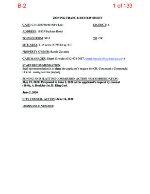
ZONING CHANGE REVIEW SHEET CASE: C14-2020-0040 (New Lot) DISTRICT: 6 ADDRESS: 11833 Buckner Road ZONING FROM: SF-3 TO: GR SITE AREA: 1.33 acres (57,934.8 sq. ft.) PROPERTY OWNER: Ramin Zavareh CASE MANAGER: Sherri Sirwaitis (512-974-3057, sherri.sirwaitis@austintexas.gov) STAFF RECOMMENDATION: Staff recommendation is to deny the applicant’s request for GR, Community Commercial District, zoning for this property. ZONING AND PLATTING COMMISSION ACTION / RECOMMENDATION: May 19, 2020: Postponed to June 2, 2020 at the applicant's request by consent (10-0); A. Denkler-1st, D. King-2nd. June 2, 2020 CITY COUNCIL ACTION: June 11, 2020 ORDINANCE NUMBER: 1 of 133B-2 ISSUES: On March 10, 2020, an Environmental Code Violation was filed for this address due to a complaint of clearing without a permit on the property. The ECV Enterprise Violation is an active red tag and the outstanding issues/fees have not been resolved (please see Exhibit C). CASE MANAGER COMMENTS: The property in question is a 1.33 acre vacant tract of land that is located on Buckner Road, a local roadway. The property to the north, across Buckner Road is undeveloped and zoned DR, Development Reserve. The tract to the south is zoned DR and contains a manufactured home and undeveloped land. The properties to the west, are also zoned DR and are developed with single family residences. The tract of land directly to the east is zoned SF-3 contains a single-family residence with outdoor storage. Further to the east, along Buckner Road, there is a lot zoned LO-CO (through case C14-2008-0199) that is developed with an office use (Time Warner Cable/Spectrum). In this request, the applicant is asking to rezone the site under consideration to the GR district to develop an automotive sales use at this location. The staff recommends denial of the applicant’s request for GR, Community Commercial District, zoning. The property does not meet the intent of the GR district as it is not located on a major roadway. While the staff has supported some commercial uses/zoning on Buckner Road, these tracts of land were located near the intersection of Buckner Road and FM 620. This proposed GR commercial zoning request is located on a designated single-family tract near the end Bucker Road, a narrow 20-foot local roadway. The property in question abuts single-family residences to the east and west. Additionally, the subject tract is located in an environmentally sensitive area adjacent to a creek where automotive uses would not be appropriate. The existing SF-3 zoning provides for a transition from the commercial zoning at the intersection of FM 620 Road and Buckner Road, to the office zoning and the residential zoning located along Buckner Road as it nears a terminus to the west. The applicant does not agree with the staff’s recommendation. BASIS OF RECOMMENDATION: 1. The proposed zoning is not consistent with the purpose statement of the district sought. Community Commercial district is intended for office and commercial uses serving neighborhood and community needs, including both unified shopping centers and individually developed commercial sites, and typically requiring locations accessible from major traffic ways. The existing SF-3 - Family residence district is the designation for a moderate density single-family residential use and a duplex use on a lot that is a minimum of 5,750 square feet. An SF-3 district designation may be applied to a use in an existing single- family neighborhood with moderate sized lots. 2 of 133B-2 The property is located on a small 20-foot wide local collector roadway where there are developed single family homes. The current SF-3 zoning would be compatible with the existing land uses in the immediate vicinity. 2. The proposed zoning should promote consistency and orderly planning. Buckner Road has a mixture of uses, from single-family, office, warehousing, storage automotive sales and automotive repair. However, the commercial uses are located at/ near the intersection of FM 620 Road. The staff has consistently recommended GR commercial zoning to a depth of 500 feet along the western side of the FM 620 corridor to allow for commercial services along this major arterial roadway. Permitting GR zoning at this location will introduce commercial uses on a tract of land that is located in an environmentally sensitive area with low visibility on a small local roadway. The staff recommends maintaining SF-3 zoning to provide for a transition down in the intensity of uses permitted along Buckner Road to the west. SF-3 zoning will allow for housing options at this location. 3. The proposed zoning should allow for a reasonable use of the property. Given the mixed character of the area, the staff believes that SF-3 zoning allows for a fair and reasonable use of the site. The properties to the north, south, west and east are zoned DR and SF-3 respectively, which permit residential uses. There are established single family residential homes (verified by TCAD property records) to the east and west on Buckner Road as it nears a terminus to the west. EXISTING ZONING AND LAND USES: Site North South East West ZONING SF-3 DR DR, County SF-3 DR LAND USES Undeveloped Tract Undeveloped Area Manufactured Home, Undeveloped Area Single-Family Residence Single Family Residences NEIGHBORHOOD PLANNING AREA: N/A TIA: Deferred to Site Plan WATERSHED: Lake Travis 3 of 133B-2 NEIGHBORHOOD ORGANIZATIONS: Bike Austin Friends of Austin Neighborhoods Leander ISD Population and Survey Analysts Sierra Club, Austin Regional Group TNR BCP – Travis County Natural Resources The Parke HOA Volente Neighborhood Association AREA CASE HISTORIES: NUMBER C14-2018-0092 (11900 Buckner Road) REQUEST GR-MU-CO, SF-6-CO to GR-MU-CO, LO-MU-CO COMMISSION 11/20/18: Approved staff’s recommendation of GR-MU-CO zoning for Tract 1 and LO-MU- CO zoning for Tract 2, with NTA conditions, by consent (8-0; D. Breithaupt, J. Kiolbasa and A. Tatkow-absent); B. Evans-1st, D. King-2nd. SF-2, GR to GR SF-2 to GR C14-2018-0076 (Sam’s Auto Shop, Part 2: 11815 Buckner Road) C14-2017-0041 (Sam’s Auto Shop: 11815 Buckner Road) 8/07/18: Approved the staff’s recommendation for GR zoning by consent (8-0, D. Breithaupt- arrived late, B. Evans-absent); S. Lavani-1st, A. Denkler-2nd. 6/06/17: Approved staff’s recommendation of GR zoning on consent (10-0, D. Breithaupt- absent); Aguirre-1st, S. Lavani-2nd. C14-2014-0082 (Stokes Ranch: 11900 Buckner Road) Tract 1: SF-2 to GR-MU and Tract 2: DR to SF-6 7/15/14: Approved staff’s recommendation of GR-MU-CO zoning for Tract 1 and SF-6-CO zoning for Tract 2, with a CO to limit the entire site to less than 2,000 vehicle trips per day and a street deed to dedicate 25 feet of right-of-way from the existing centerline of Buckner Road, CITY COUNCIL and hearing 12/13/18: The public hearing was conducted and a motion to close the public approve Ordinance No. 20181213-075 for GR-MU-CO zoning for Tract 1 and LO-MU-CO zoning for Tract 2, with conditions was approved on Council Member Alter’s motion, Council Member Casar’s second on a 9-0 vote. Mayor Adler was off the dais. Council Member Renteria was absent. 8/30/18: Approved GR zoning on all 3 readings by consent (11-0); L. Pool-1st. P. Renteria-2nd. 8/03/17: The public hearing was conducted and a motion to close the public hearing and approve Ordinance No. 20170803-106 for community commercial (GR) district zoning was approved on Council Member Garza’s motion, Council Member Casar’s second on an 11-0 vote. 8/07/14: Approved CS-CO zoning by consent on 1st reading only (7-0); B. Spelman-1st, M. Martinez-2nd. 10/16/14: Approved GR-MU-CO zoning for Tract 1 and SF-6-CO zoning for Tract 2 on consent on Mayor Pro Tem Cole’s motion, 4 of 133B-2 by consent (5-0, C. Banks & S. Compton-absent); P. Seeger-1st, R. McDaniel-2nd. Council Member Morrison’s second on a 7-0 vote. LR-CO to CS-1 10/05/10: Approved the CS-1-CO 10/28/10: Approved CS-l-CO zoning on consent on 2nd/3rd readings (7-0); B. Spelman-1st, L. Morrison-2nd. C14-2010-0152 M&S Project #2: 10601 N. FM 620 Road) zoning with the following conditions: 1) Limit the property to 2,000 vehicle trips per day per Ordinance No. 010125-14; 2) Prohibit Cocktail Lounge, Exterminating Services, Pawn Shop Services, Hotel-Motel, Indoor Sports and Recreation, and Auto Related Uses and 3) Limit the site to all other GR permitted uses (7-0); S. Baldridge-1st, P. Seeger-2nd. 10/31/08: Approved staff rec. of LO-CO zoning by consent (4-0) 2/01/05: Approved staff’s recommendation on consent for P- CO for Tract 1, GO-CO for Tract 2, with additional conditions to: 1) Prohibit access to Savannah Ridge Drive (other than for emergency vehicles), 2) Create a Tract 3 designated as RR-CO district zoning for a distance of 300-feet from the eastern most property line that is adjacent to SF-2 zoning, Vote: (9-0); J. Martinez-1st, J. Gohil-2nd. 3/29/05: Approved staff rec. of SF-3 zoning by consent (7-0) 12/21/04: Approved MF-2-CO, with staff condition to limit development to less than 2,000 vehicle trips per day beyond the existing development and additional condition for a 568 unit limit for the site (9-0) 9/21/04: Approved staff’s recommendation of MF-1-CO zoning by consent (7-0, K. Jackson-off dais, J. Gohil-absent) 12/02/08: Approved LO-CO zoning (6-0); all 3 readings 3/03/05: Approved P-CO for Tract 1, GO- CO for Tract 2, and RR-CO for Tract 3(7-0); all 3 readings 5/12/05: Approved SF-3 zoning (7-0); 1st reading 6/23/05: Approved SF-3 zoning; 2nd/3rd readings 1/27/05: Approved MF-2-CO (6-0, Dunkerley-absent); 1st reading 3/03/05: Approved MF-2-CO on consent (7-0); 2nd/3rd readings 10/21/04: Approved ZAP recommendation of MF-1-CO by consent (7-0); 1st reading C14-2008-0199 (Time Warner 620 HUB: 11827 Buckner Road) C14-04-0207 (ECO Resources: 9511 North FM 620 Road) DR to LO-CO I-RR to Tract 1: P and Tract 2: GO DR to CS* * Amended request to SF-3 on 1/03/05 I-RR to MF-3 I-RR to MF-1 C14-04-0197 (Buckner: 11833 Buckner Road) C14-04-0183 (Escalon at Canyon Creek Apartments: 9715 North FM 620 Road) C14-04-0137 (Estates at Canyon Creek: 9501 North FM 620 Road) 5 of 133B-2 C14-04-0035 (Eppright 12-Acre Tract: 9300-9800 Block of North FM 620 Road) C14-04-0003 (Canyon Creek West Section Three: 9800-9920 Block of Savannah Ridge Drive) C14-04-0002 (Canyon Creek West Section One: 10012- 10129 Brabrook Drive) C14-02-0154 (McDougal 620 Property: Windy Ridge Road at North FM 620 Road SF-2, DR to CS-CO C14-00-2122 (M & S Corner: North FM 620 Road) RR to CS-1-CO for Tract 1 and LR-CO for Tracts 2 & 3 11/4/04: Approved MF-1-CO (7-0); 2nd/3rd readings 8/12/04: Granted SF-6-CO on all 3 readings (5-1, B. McCracken – No, J. Goodman – off the dais) I-RR to SF-6 5/18/04: Approved staff’s rec. for SF-6-CO zoning, with the addition of the conditions listed in the Letter of Agreement between the applicant and the neighborhood, by consent (8-0) 2/3/04: Approved staff’s recommendation of SF-2 zoning, by consent (9-0) I-RR, I-SF-2 to SF-2 3/4/04: Granted SF-2 zoning (6-0, McCracken-absent); all 3 readings I-SF-2, I-RR to SF-2 2/3/04: Approved staff’s recommendation of SF-2 zoning, by consent (9-0) 3/4/04: Granted SF-2 zoning (6-0, McCracken-absent); all 3 readings 1/28/03: Approved W/LO-CO zoning with conditions of: • Limiting trips to 2,000 per day; • 50' vegetative buffer along the western property line; • 20' buffer along the southern property line; • Prohibit access on the western property line, with the exception of emergency access; • Only 2 access points on the southern property line; • Restrict semi-trucks, 3 axles or more to Windy Ridge entrance. Vote: (7-1, J.P.-Nay, J.D.-absent); K.J.-1st, M. W.-2nd. 9/12/00: Approved LR-CO zoning for Tracts 1, 2, &3 with following conditions: 1) Limit vehicle trips to 2,000 per day for Tracts 1&2; 2) Limit vehicle trips to 3,223 per day for Tract 3; 3) Property owner shall have a 10-foot setback with a vegetative buffer and hooded lights; 4) Garbage pickup shall be from 6-10 p.m.; 5) Construct an 8 foot fence (7-0, B.B. & S.A.- absent); S.L.-1st, B.H.-2nd. 3/20/03: Approved staff recommendation of GR-CO for 1st 700 feet off 620 and RR for balance (7-0); 1st reading only 3/25/03: Approved staff recommendation of GR-CO for 1st 700 feet off 620 and RR for balance (7-0); 2nd reading 1/27/05: Approved staff recommendation of GR-CO for 1st 700 feet off 620 and RR for balance (7-0); 3rd reading 10/12/00: Approved Planning Commission rec. of LR-CO, with conditions (7-0); 1st reading 11/30/00: Approved LR-CO for Tracts 1&2, and CS-1-CO for Tract 3, prohibiting cocktail lounge use (7-0); 2nd reading 1/25/01: Approved LR-CO for Tracts 1&2, and CS-1-CO for Tract 3, with the following conditions: 1) A 10-foot building setback along the east property 6 of 133B-2 line; 2) Limit vehicle trips to 2,000 per day for Tracts 1&2; 3) Limit vehicle trips to 3,223 per day for Tract 3; 4) Prohibit the following uses on Tract 1: Adult Businesses, Automotive Rental, Automotive Repair Services, Automotive Sales, Automotive Washing, Agricultural Sales and Services, Art and Craft Studio (General), Building Maintenance Services, Business or Trade School, Business Support Services, Campground, Cocktail Lounge, Commercial Blood Plasma Center, Commercial Off-Street Parking, Communication Services, Construction Sales and Services, Convenience Storage, Drop-Off Recycling Collection Facility, Electronic Prototype Assembly, Equipment Repair Services, Equipment Sales, Exterminating Services, Funeral Services, General Retail Sales, Hotel- Motel, Indoor Entertainment, Indoor Sports and Recreation, Kennels, Laundry Services, Monument Retail Sales, Outdoor Sports and Recreation, Pawn Shop Services, Personal Improvement Services, Research Services, Restaurant (General), Theater, Vehicle Storage, Veterinary Services, Custom Manufacturing, Limited Warehousing and Distribution, Maintenance and Service Facilities (7-0); 3rd reading RELATED CASES: C14-04-0197- Previous Rezoning Case 2020-056323 - PR Plan Review (Application on April 7, 2020 for new 1-story single-family residence with one bedroom and 1 bathroom and a detached four car garage) 7 of 133B-2 EXISTING STREET CHARACTERISTICS: Name Existing ROW ASMP Required ROW Pavement ASMP Classification Sidewalks Bicycle Route Capital Metro (within ¼ mile) Buckner Road ~44’ Existing 20’ 1 No No No OTHER STAFF COMMENTS: Comprehensive Planning This zoning case is located on the south side of Buckner Road. The property is 1.33 acres in size, undeveloped and is not located within the boundaries of an existing neighborhood planning area. Surrounding land uses includes vacant land and single-family housing to the north; to the south is vacant land; to the west is single family housing and vacant land; and to the east is vacant land, single family housing and commercial uses. The proposed use is auto sales and service. Connectivity There are no public sidewalks or a Cap Metro transit stop located along this portion of Buckner Road or along the adjacent FM 620. The mobility and connectivity options in this area are below average. Imagine Austin The property is not situated along an Activity Corridor or by an Activity Center but it is adjacent to a creek buffer/waterway setback and erosion hazard zone review buffer zone, which is an environmentally sensitive feature. The following Imagine Austin policy is applicable to this case: • LUT P4. Protect neighborhood character by directing growth to areas of change that include designated redevelopment areas, corridors and infill sites. Recognize that different neighborhoods have different characteristics and new and infill development should be sensitive to the predominant character of these communities. • LUT P22. Protect Austin’s natural resources and environmental systems by limiting land use and transportation development in sensitive environmental areas and preserving areas of open space. • HN P11. Protect neighborhood character by directing growth to areas of change and ensuring context sensitive infill in such locations as designated redevelopment areas, corridors, and infill sites. Although previous zoning cases have introduced commercial uses along Buckner Road, these were largely located closer to intersection of Buckner Road and FM 620. The proposed zone change is located at the end of a narrow road and adjacent to an enclave of single-family houses and appears to be a case of commercial encroachment. Additionally, the subject tract 8 of 133B-2 is located in an environmentally sensitive area, next to a creek. Spills and runoff associated with automobile sales and repair could inadvertently contribute to increased ground water pollution. Based upon adjacent residential uses, which represents commercial encroachment, and the property being in an environmentally sensitive area, this proposed commercial project does not support the policies of the Imagine Austin Comprehensive Plan. Environmental The site is located over the Edwards Aquifer Recharge Zone. The site is in the Lake Travis Watershed of the Colorado River Basin, which is classified as a Water Supply Rural Watershed by Chapter 25-8 of the City's Land Development Code. It is in the Drinking Water Protection Zone. Under current watershed regulations, development or redevelopment on this site will be subject to the following impervious cover limits: Development Classification % of Net Site Area % NSA with Transfers Allowable Density One or Two Family Residential Multifamily Residential Commercial n/a 20% 20% n/a 25% 25% n/a n/a 1 unit/2 acres net site area Single family or duplex development within a Water Quality Transition Zone may not exceed a density of one unit per three acres, exclusive of land within a 100-year floodplain. According to floodplain maps there is a floodplain within or adjacent to the project location. Based upon the location of the floodplain, offsite drainage should be calculated to determine whether a Water Quality Transition Zone / Critical Water Quality Zone exist within the project location. Standard landscaping and tree protection will be required in accordance with LDC 25-2 and 25-8 for all development and/or redevelopment. At this time, site specific information is unavailable regarding vegetation, areas of steep slope, or other environmental features such as bluffs, springs, canyon rimrock, caves, sinkholes, and wetlands. Under current watershed regulations, development or redevelopment requires water quality control with increased capture volume and control of the 2-year storm on site. At this time, no information has been provided as to whether this property has any preexisting approvals that preempt current water quality or Code requirements. 9 of 133B-2 Site Plan Site plans will be required for any new development other than single-family or duplex residential. Any development which occurs in an SF-6 or less restrictive zoning district which is located 540 feet or less from property in an SF-5 or more restrictive zoning district will be subject to compatibility development regulations. Any new development is subject to Subchapter E. Design Standards and Mixed Use. Additional comments will be made when the site plan is submitted. Compatibility Standards The site is subject to compatibility standards. Along the east, west, and southern property line, the following standards apply: • No structure may be built within 25 feet of the property line. • No structure in excess of two stories or 30 feet in height may be constructed within 50 feet of property zoned SF-5 or more restrictive. • No structure in excess of three stories or 40 feet in height may be constructed within 100 feet of the property line. • No parking or driveways are allowed within 25 feet of the property line. • A landscape area at least 25 feet wide is required along the property line. In addition, a fence, berm, or dense vegetation must be provided to screen adjoining properties from views of parking, mechanical equipment, storage, and refuse collection. • For a structure more than 100 feet but not more than 300 feet from property zoned SF-5 or more restrictive, height limitation is 40 feet plus one foot for each 10 feet of distance in excess of 100 feet from the property line. • For a structure more than 300 feet but not more than 540 feet from property zoned SF-5 or more restrictive, 60 feet plus one foot for each four feet of distance in excess of 300 feet from the property zoned SF-5 or more restrictive. • An intensive recreational use, including a swimming pool, tennis court, ball court, or playground, may not be constructed 50 feet or less from adjoining SF-3 property. • A landscape area at least 25 feet in width is required along the property line if the tract is zoned LR, GO, GR, L, CS, CS-1, or CH. Height compatibility standards are triggered along the northern property line: • No structure in excess of two stories or 30 feet in height may be constructed within 50 feet of property zoned SF-5 or more restrictive. • No structure in excess of three stories or 40 feet in height may be constructed within 100 feet of the property line. • For a structure more than 100 feet but not more than 300 feet from property zoned SF-5 or more restrictive, height limitation is 40 feet plus one foot for each 10 feet of distance in excess of 100 feet from the property line. • For a structure more than 300 feet but not more than 540 feet from property zoned SF-5 or more restrictive, 60 feet plus one foot for each four feet of distance in excess of 300 feet from the property zoned SF-5 or more restrictive. 10 of 133B-2 Transportation Water Utility The Austin Strategic Mobility Plan (ASMP) adopted 04/11/2019, identifies existing right-of- way appears as sufficient, but will be reviewed at the time of site plan. A traffic impact analysis should be deferred until the time of site plan when final land uses and intensities are known. City of Austin water and wastewater service is not available to serve this tract. Individual private wells and On-Site Sewage Facilities may be utilized, or Service Extension Requests must be submitted to obtain City service. For more information pertaining to the private well and On-Site Sewage Facilities process and submittal requirements contact the AW OSSF team at OSSF@austintexas.gov or call 512-972-0050. For more information pertaining to the Service Extension Request process and submittal requirements contact Alberto Ramirez with Austin Water, Utility Development Services at 625 E. 10th St., 7th floor. Ph: 512-972-0211. INDEX OF EXHIBITS TO FOLLOW A: Zoning Map B. Aerial Map C. ECV Enterprise Violation Information D. Plan Review Residential Construction Permit E. Information Provided by the Applicant F. Correspondence from Interested Parties 11 of 133B-2 DR HANGING VALLEY DR DR C14-2020-0040 C14-04-0197 SF-3 04-0197 EXHIBIT A SP-05-1665D RR C14-02-0154 BOAT SALES 02-0154 DR WINDY RIDGE RD 02-0154 GR-CO SF-2 C14-2018-0092 LO-MU-CO C14-2014-0082 C14-2014-0082 GR-MU-CO C14-2018-0092 BUCKNER RD LO-CO C14-2008-0199 VACANT DR E FIC F O SPORTS EQUIPMENT SALES SF-2 W H S E C14-2018-0076 C14-2017-0041 SF-2 REPAIR GR LR-CO C14-00-2122 00-2122 B O ULD ER LN A 0 1 3 3-0 -9 C P S SF-6 NO-CO 058 92-0 POOL SALES N F M 620 RD BOAT\SALES AUTO\REPAIR CHURCH CHURCH SF-2 99-0022 99-0022 C14-99-0022 SF-2 C7A-84-001 C7A-04-013 MF-2-CO C14-04-0183 DR C7A-84-021 C7A-04-013 DR ( ( RETAIL\SALES\GENERAL ZONING ZONING CASE#: C14-2020-0040 DR I-RR GR-CO C14-2010-0100 SUBJECT TRACT ! ! ! ! ! ! PENDING CASE ZONING BOUNDARY ± This product is for informational purposes and may not have been prepared for or be suitable for legal, engineering, or surveying purposes. It does not represent an on-the-ground survey and represents only the approximate relative location of property boundaries. 1 " = 400 ' This product has been produced by CTM for the sole purpose of geographic reference. No warranty is made by the City of Austin regarding specific accuracy or completeness. Created: 3/19/2020 12 of 133B-2 RR DR C14-2020-0040 BUCKNER RD SF-3 D37 LO-MU-CO LO-CO DR SF-2 ± 1'' = 200' SUBJECT TRACT ZONING BOUNDARY ! ! ! ! ! ! PENDING CASE CREEK BUFFER NEW LOT ZONING CASE#: LOCATION: SUBJECT AREA: GRID: MANAGER: C14-2020-0040 11833 BUCKNER RD. 1.33 ACRES D37 Sherri Sirwaitis This map has been produced by the Communications Technology Management Dept. on behalf of the Planning Development Review Dept. for the sole purpose of geographic reference. No warranty is made by the City of Austin regarding specific accuracy or completeness. 13 of 133B-2 EXHIBIT B RR DR C14-2020-0040 BUCKNER RD SF-3 D37 LO-MU-CO LO-CO DR SF-2 ± 1'' = 200' SUBJECT TRACT ZONING BOUNDARY ! ! ! ! ! ! PENDING CASE CREEK BUFFER NEW LOT ZONING CASE#: LOCATION: SUBJECT AREA: GRID: MANAGER: C14-2020-0040 11833 BUCKNER RD. 1.33 ACRES D37 Sherri Sirwaitis This map has been produced by the Communications Technology Management Dept. on behalf of the Planning Development Review Dept. for the sole purpose of geographic reference. No warranty is made by the City of Austin regarding specific accuracy or completeness. Copyright nearmap 2015 14 of 133B-2 EXHIBIT C Wyrick, Amanda Sirwaitis, Sherri RE: Status of Red Tag for 11833 Buckner Road Monday, May 11, 2020 3:02:47 PM image001.png From: To: Subject: Date: Attachments: Sherri, The site still has an active Stop Work Order for development(clearing of vegetation) that was done without a permit. The owner has installed erosion controls and is going through the site plan process to obtain a permit for the development that has occurred and for future plans. The Zoning case is the first step towards obtaining compliance on the property. I hope this helps. Please let me know if there is anything else I can help with. Amanda Wyrick Environmental Compliance Specialist Senior City of Austin Development Services Department 5202 E. Ben White Blvd, Bldg 2, Suite 300 Work Cell: 512-999-4535 PER CITY ORDINANCE: All individuals scheduling or accepting a meeting invitation with a City Official are requested to provide responses to the questions at the following link: DSD Visitor Log. Please note that all information provided is subject to public disclosure via DSD’s open data portal. For more information please visit: City of Austin Ordinance 2016-0922-005 | City Clerk’s website | City Clerk’s FAQ’s From: Sirwaitis, Sherri Sent: Monday, May 11, 2020 2:29 PM To: Wyrick, Amanda <Amanda.Wyrick@austintexas.gov> Subject: Status of Red Tag for 11833 Buckner Road Importance: High Hi Amanda, I see that there is an ECV Enterprise Violation/ red tag for clearing on the property at 11833 Buckner Road. Can you tell me if this violation has been cleared or is the red tag still active? I have a rezoning request for this property from SF-3 zoning to GR zoning that is scheduled to be heard by the Zoning and Platting Commission next Tuesday night (5/19/20). I am working to compile the backup material for the meeting and I want to make sure that I have all of the current information regarding the property. Thank you, 15 of 133B-2 Sherri Sirwaitis City of Austin Planning & Zoning Department sherri.sirwaitis@austintexas.gov 512-974-3057(office) 16 of 133B-2 EXHIBIT D Residential New Construction and Addition Permit Application Residential Review – One Texas Center 505 Barton Springs Road, Austin, TX 78704; Phone 3-1-1 Property Information Project Address: Legal Description: Zoning District: Neighborhood Plan Area (if applicable): Required Reviews Tax Parcel ID: Lot Area (sq ft): Historic District (if applicable): Is project participating in S.M.A.R.T. Housing? (If yes, attach signed certification letter from NHCD, and signed conditional approval letter from Austin Energy Green Building) Y N Does project have a Green Building requirement? (If yes, attach signed conditional approval letter from Austin Energy Green Building) Y N Is this site within an Airport Overlay Zone? (If yes, approval through Aviation is required) Y N Does this site have a septic system? Y N (If yes, submit a copy of approved septic permit. OSSF review required) Does the structure exceed 3,600 square feet total under roof? Is this property within 200 feet of a hazardous pipeline? Y Y N N (If yes, Fire review is required) (If yes, Fire review is required) Is this site located within an Erosion Hazard Zone? Is this property within 100 feet of the 100-year floodplain? Y N (If yes, EHZ review is required) Y N (Proximity to floodplain may require additional review time.) Are there trees 19” or greater in diameter on/adjacent to the property? If yes, how many?_____ ( Provide plans with a tree survey, tree review required.) Y N Was there a pre-development consultation for the Tree Review? Y N Is this site in the Capital View Corridor? (If yes, a preliminary review through land use is needed to determine if full view corridor review is required.) Does this site currently have: water availability? wastewater availability? Y Y Y N N N Proposed impacts to trees: (Check all that apply) Root zone Canopy Removal None/Uncertain Is this site within the Residential Design and Compatibility Standards Ordinance Boundary Area? (LDC 25-2 Subchapter F) Y N (If no, contact Austin Water Utility to apply for water/wastewater taps and/or service extension request.) Does this site have or will it have an auxiliary water source? (Auxiliary water supplies are wells, rainwater harvesting, river water, lake water, reclaimed water, etc.) Does this site require a cut or fill in excess of four (4) feet? Y N (If yes, contact the Development Assistance Center for a Site Plan Exemption) (If yes, submit approved auxiliary and potable plumbing plans.) N Y Is this site within the Waterfront Overlay? (LDC 25-2 Subchapter C Article 3) Y N Is this site within the Lake Austin Overlay? (LDC 25-2-180, 25-2-647) Y N Does this site front a paved street? (If no, contact Development Assistance Center for Site Plan requirements.) Does this site have a Board of Adjustment (BOA) variance? Y N (If yes, provide a copy of decision sheet. Note: A permit cannot be approved within 10 days of approval of a variance from BOA.) Description of Work Is this site adjacent to a paved alley? (Public Works approval required to take access from a public alley.) Y Y N N Case # _________________________ (if applicable) Is Total New/Added Building Area > 5,000 sq. Ft.? Y N (If yes, construction material recycling is required per LDC 25-11-39) Existing Use: vacant single-family residential duplex residential two-family residential other: _________ Proposed Use: vacant single-family residential duplex residential two-family residential other: _________ Project Type: new construction addition addition/remodel other:__________ Will all or part of an existing exterior wall, structure, or roof be removed as part of the project? (Notes: Removal of all or part of a structure requires a Demolition Permit Application per LDC 25-11-37. A demo permit is not required for the removal of all or part of an interior wall, floor or ceiling) # existing bedrooms: # bedrooms upon completion: # baths upon completion: # baths existing: Y N Project Description: (Note: Please provide thorough description of project. Attach additional pages as necessary.) _________________________________________________________________________________________________ _________________________________________________________________________________________________ _________________________________________________________________________________________________ Trades Permits Required (Check as applicable): mechanical (HVAC) concrete (R.O.W.) plumbing electric City of Austin | Residential New Construction and Addition Permit Application 10/4/2019 | Page 1 of 7 17 of 133B-2 0 0 0 0 0 0 0 0 0 0 0 0 0 0 0 0 0 0 0 0 0 0 0 0 Total Remodeled Floor Area (if applicable) 0 sq ft. (work within existing habitable square footage) Job Valuation – For Properties in a Floodplian Only Total Job Valuation: $__________ 0 ______ Amount for Primary Structure: Elec: Y N | Plmbg: Y $ ________________ N | Mech: Y N Note: The total job valuation should be the sum total of all valuations noted to the right. Labor and materials only, rounded to nearest dollar. Amount for Accessory Structure: Elec: Y N | Plmbg: Y $ ________________ N | Mech: Y N Existing sq. ft. to Remain New/Added sq. ft. Total sq. ft. Bldg. 1 Bldg. 2 Bldg. 1 Bldg. 2 Bldg. 1 Bldg. 2 Site Development Information Area Description Note: Provide a separate calculation for each distinct area. Attach additional sheets as necessary. Measurements are to the outside surface of the exterior wall. a) 1st Floor conditioned area b) 2nd Floor conditioned area c) 3rd Floor conditioned area d) Basement e) Covered parking (garage or carport) f) Covered patio, deck, porch, and/or balcony area(s) g) Other covered or roofed area h) Uncovered wood decks i) Pool j) Spa k) Remodeled Floor Area, excluding Addition / New Construction Total Building Area (total a through h) 0 0 0 0 The Calculation Aid on page 7 is to be used to complete the following calculations and to provide additional information. Building Coverage Information Note: Building Coverage means the area of a lot covered by buildings or roofed areas, but excludes ground-level paving, landscaping, open recreational facilities, incidental projecting eaves, balconies, and similar features. Pools, ponds, and fountains are not included in this measurement. (LDC 25-1-21) Total Building Coverage (sq ft): ___________ % of lot size: ________ Impervious Cover Information Note: Impervious cover is the total horizontal area of covered spaces including building coverage, paved areas, walkways, and driveways. The term excludes pools, ponds, fountains, and areas with gravel placed over pervious surfaces that are used only for landscaping or by pedestrians. For an uncovered wood deck that has drainage spaces between the deck boards and that is located over a pervious surface, 50 percent of the horizontal area of the deck is included in the measurement of impervious cover. (LDC 25-1-23) Total Impervious Cover (sq ft): _____________ % of lot size: ________ Setbacks Are any existing structures on this site a non-compliant structure based on a yard setback requirement? (LDC 25-2-492) Does any structure (or an element of a structure) extend over or beyond a required yard? (LDC 25-2-513) Is front yard setback averaging being utilized on this property? (LDC 25-2, Subchapter F, Sec. 2.3 or 25-2-778) Height Information (LDC 25-1-21 or 25-2 Subchapter F, Section 3.4) Parking (LDC 25-6 Appendix A & 25-6-478) Y Y N N Y N Building Height: _______ ft ___ in Number of Floors: _____ # of spaces required: ________ # of spaces provided: ________ Right-of-Way Information Is a sidewalk required for the proposed construction? (LDC 25-6-353) *Sidewalks are to be installed on any new construction of a single family, two-family or duplex residential structure and any addition to an existing building that Y N increases the building’s gross floor area by 50 % or more. Will a Type I driveway approach be installed, relocated, removed or repaired as part of this project? Y N Width of approach (measured at property line): ___________ ft Distance from intersection (for corner lots only): __________ ft Are storm sewer inlets located along the property or within ten (10) feet of the boundaries of the property? (If driveway is located within 10 feet of driveway, Drainage review is required) Y N City of Austin | Residential New Construction and Addition Permit Application 10/4/2019 | Page 2 of 7 18 of 133B-2 Subchapter F Gross Floor Area This section is only required for projects located within the Residential Design and Compatibility Standards Ordinance Boundaries as defined and illustrated in Title 25-2 Subchapter F of the Land Development Code. The Gross Floor Area of each floor is measured as the area contained within the outside edge of the exterior walls. Existing sq. ft. New/Added to remain sq. ft. Proposed Exemption (check article utilized) Applied Total sq. ft. Exemption sq. ft. 0 0 0 0 0 0 0 0 0 0 0 0 0 1st Floor 2nd Floor 3rd Floor Attic 5 Garage2 (check article utilized) Carport2: (check article utilized) Area w/ ceilings > 15’ Ground Floor Porch1 (check article utilized) Basement 4 Attached Detached Attached Detached Accessory Building(s) (detached) Totals Must follow article 3.3.5 Full Porch sq. ft. (3.3.3.A) 200 sq. ft. (3.3.3 A 2) Must follow article 3.3.3B, see note below Must follow article 3.3.3C, see note below 200 sq. ft. (3.3.2 B 1) 450 sq. ft. (3.3.2 A 1 / 2a) 200 sq. ft. (3.3.2 B 2a / 2b) 450 sq. ft. (3.3.2 A 3) 200 sq. ft. (3.3.2 B 1)3 450 sq. ft. (3.3.2 A 1) 0 0 TOTAL GROSS FLOOR AREA (Total Gross Floor Area ÷ Lot Area) x 100 = ___________________ Floor-To-Area Ratio (FAR) Is a sidewall articulation required for this project? Y N (Yes, if: a wall, 15’ tall or higher, within 9 feet of a side property line extends further than 36 feet in length per article 2.7.1) Does any portion of the structure extend beyond a setback plane/exemption exhibit (aka “tent”)? (If Yes, indicate applicable section of Subchapter F and length of protrusion on the drawings.) Y N 1 Ground Floor Porch exemption: A ground floor porch, including a screened porch, may be exempted, provided that the porch is not accessible by automobile and is not connected to a driveway; and the exemption may not exceed 200 square feet if a porch has habitable space or a balcony above it. 2 Garage and carport exemptions (in relation to primary structure): Exemptions must follow the code as outlined in Title 25-2 Subchapter F 3.3.2. Each amount listed (450 or 200) is the maximum exclusion allowed per the article designated. Note: Article 3.3.2 C, “An applicant may receive only one 450-square foot exemption per site under paragraph A. An applicant who receives a 450-square foot exemption may receive an additional 200-foot exemption for the same site under paragraph B, but only for an attached parking area used to meet minimum parking requirements.” 3Ordinance article 3.3.2 B 1 is 200 sq. ft. exemption may be combined with a 450 sq. ft. exemption. Otherwise only one 450 exemption or one 200 sq. ft. exemption may be taken. 4 Basement exemption: A habitable portion of a building that is below grade may be exempted if the habitable portion does not extend beyond the first-story footprint and is below natural or finished grade, whichever is lower; and it is surrounded by natural grade for at least 50% of its perimeter wall area and the finished floor of the first story is not more than three feet above the average elevation at the intersections of the minimum front yard setback line and the side property lines. 5 Habitable Attic exemption: A habitable portion of an attic may be exempted if: 1) The roof above it is not a flat or mansard roof and has a slope of 3 to 12 or greater; 2) It is fully contained within the roof structure; 3) It has only one floor; 4) It does not extend beyond the footprint of the floors below; 5) It is the highest habitable portion of the building, or a section of the building, and adds no additional mass to the structure; and 6) Fifty percent or more of the area over 5 feet has a ceiling height of seven feet or less. City of Austin | Residential New Construction and Addition Permit Application 10/4/2019 | Page 3 of 7 19 of 133B-2 Contact Information Mailing Address Owner Phone Email Phone Email General Contractor Mailing Address Applicant/Agent Mailing Address Phone Email Phone Email Design Professional Mailing Address Authorization ___ I understand that in accordance with Sections 25-1-411 and 25-11-66 of the Land Development Code (LDC), non-compliance with the LDC may be cause for the Building Official to suspend or revoke a permit and/or license. ___ I further understand that no portion of any roof structure may overhang in any public utility or drainage easement. I acknowledge that customer will bear the expense of any necessary relocation of existing utilities to clear this driveway location and/or the cost to repair any damage to existing utilities caused during construction. Water services, meters, and wastewater cleanouts are not permitted within or beneath driveways or sidewalks. Private plumbing appurtenances will not be located in public right-of-way or public easements. Private plumbing lines will not cross lot lines. ___ I agree that this application is good for twelve (12) months after the date it is filed, and will expire if not approved for compliance within that time frame. If the application expires, a new submittal will be required and compliance with current code may be required. ___ I hereby certify that to the best of my knowledge and ability, the information provided in this application is complete and accurate. I further acknowledge that, should any information contained herein prove incorrect, the building official may suspend or revoke any resulting permit and/or license. ___ As owner or authorized agent, my signature authorizes staff to visit and inspect the property for which this application is being submitted. I understand that without consent the review process may be delayed. ___ I also understand that if there is a septic system located on the property, I am required to complete an On-site Sewage Facility (a.k.a. an OSSF or septic system) application by contacting Austin Water at (512) 972-0050 or ossf@austintexas.gov . This initiates the septic system permitting requirement needed to proceed with the development review process. ___ Erosion and Sedimentation Controls are required per Section 25-8-181 of the LDC. Failure to comply with this requirement may result in a Stop Work Order and/or legal action by the City of Austin including criminal charges and fines of up to $2,000.00 per day. ___ I am the record owner of this property and authorize the agent/applicant listed above to apply for and acquire a permit on my behalf. ___ I have checked for any property-specific information that may affect the review and/or construction of this project, including but not limited to: any subdivision notes, deed restrictions, restrictive covenants, zoning conditional overlays, and/or other requirements specific to proposed development on this property (collectively, the “Property Information”), located at: __________________________________. deed restrictions that may apply to this property. ___ I understand that the review of this project by the City of Austin will not include a review of any private restrictive covenants or ___ I am responsible for any conflicts between the Property Information and the request submitted to the City of Austin. I further acknowledge that I understand the implications of use and/or development restrictions that are a result of the Property Information. Additionally, I understand that the issuance of a City permit for this project does not affect the enforceability of any private restrictive covenants applicable to the property. ____I understand that if requested I must provide copies of any and all of the Property Information that may apply to this property. Owner’s signature: _________________________________________________________ Date: ____________________________ Applicant’s signature: ______________________________________________________ Date: ____________________________ Design Professional’s signature: ______________________________________________ Date: ____________________________ General Contractor’s signature: _______________________________________________ Date: ____________________________ City of Austin | Residential New Construction and Addition Permit Application 10/4/2019 | Page 4 of 7 20 of 133B-2 Residential New Construction and Addition Permit Application Residential Review – One Texas Center 505 Barton Springs Road, Austin, TX 78704; Phone 3-1-1 Additional Information Application Process Please submit all documents single-sided. Submission requirements: Completed application 2 large-format sets of permit exhibits (11”x17”, 12”x18”, 18”x24”, or 24”x36”) 1 small-format set of permit exhibits (11”x17”, 8.5”x14”, or 8.5”x11”) Austin Energy Building Service Plan Application (BSPA) Note: The BSPA and the small-format plot plan must be stamped by AE in the Development Assistance Center on the first (1st) floor of the One Texas Center prior to submittal Austin Water Utility W&WW Service Plan Verification, if water demand is to increase or a dwelling is added. (e.g. addition of a bath) Note: The AWU form and the small-format plot plan must be stamped by AWU in the Development Assistance Center on the first (1st) floor of the One Texas Center prior to submittal Completed Demolition application with all required documentation, if any portion of an exterior wall is to be removed or modified. If submitting for a total demolition for new construction, demolition application must be submitted separately. All drawings must be to a City of Austin verifiable scale, see Building Criteria Manual for additional details and a list of acceptable scales. Check for expired permits: https://abc.austintexas.gov/web/permit/public-search-other?reset=true If there are expired permits associated with this property, they must be resolved. This can be done in the following ways: Submit an Acknowledgement of Expired Permits form with this application if the work is not related to the work being permitted. OR Include it in the description of work on this application and reference expired permits to be resolved If the Acknowledgement of Expired Permits form is used for this project, information about what will be required to resolve the expired permit(s) can be obtained during Residential Review General Information Walk-in hours. All new construction must comply with the Visitability Ordinance. Submit application package during Intake hours. For hours and additional information go to our website at http://www.austintexas.gov/department/residential-building-review About the Review Disciplines Technical Review – Any permit exhibits not sealed and signed by a Texas-registered architect or certified building designer will be subject to a limited technical review. The technical review is not intended to be exhaustive of all possible building code requirements. Erosion Hazard – There is a review of structural design if a property is located in the Erosion Hazard Zone, as defined by the boundaries located on the City of Austin GIS map. These zones align with locations where water flow and watershed could lead to erosion damage of the surrounding land features (e.g creeks, stream beds, …). Fire Review – There is additional review of a project if the square footage of a structure exceeds 3,600 square feet in area. The 3,600 sq. ft. includes the total goss building area: all first, second, and additional floor areas; attached covered porches, patios, decks, and balconys; attached garages; and any other attached roofed areas. The review ensures adequate proximity to fire hydrants and sufficient water supply to the hydrants based on the total gross area of the structure. Properties within 200 feet of a hazardous pipeline may also require additional review. Floodplain Review – Any work requiring a permit on property located within 100 feet of the 100-Year floodplain will require additional review. If review is anticipated, include supporting information such as FEMA elevation certificate form 086-0-033 and/or topographic surveys referencing NAVD88. To check your property for proximity to a flood plain visit www.ATXFloodPro.com or the City’s Floodplain Development Information website. Historic Review – There is additional review of exterior changes if property is a City Landmark or located in a Local Historic District, National Register Historic District, H or HD zoned district, or partial demolition of exterior features on property over 45 years old. Tree Review – All design proposals must abide by the Tree Preservation Criteria set forth in Section 3.5.2 of the City of Austin’s Environmental Criteria Manual. Cut and fill is limited to 4” within ½ Critical Root Zones (foundations cannot adhere to this), canopy removal is limited to 25% or less per tree, and 50% or more of the full Critical Root Zone must be kept at natural grade with natural ground cover. If proposing to remove a tree that is dead, diseased or an imminent hazard, please provide a Tree Risk Assessment from a Certified Arborist and/ or photographic evidence City of Austin | Residential New Construction and Addition Permit Application 10/4/2019 | Page 5 of 7 21 of 133B-2 Documentation Explanations and Definitions Additional Information, Continued Permit Exhibits: Plot Plan – Plot Plans must be drawn to a standard scale and are to include but are not limited to the following items: property address and legal description, north arrow, drawing scale, trees within the ROW or trees equal to or greater than 19 inches in diameter located on the property and immediately adjacent to the property, property lines, building lines for both existing and proposed improvements, easements, required zoning setbacks and roof overhangs, water meter and wastewater cleanout locations, underground and overhead utility lines and appurtenances, and water and/or wastewater line size and material. Floorplan(s) – Floorplans must be drawn to a standard scale and are to include (but are not limited to) the following items: drawing scale, room labels, new wall measurements, new ceiling heights, new door and window schedule, smoke detector* and carbon monoxide detector** specifications and locations, dimensioned locations of new plumbing fixtures, handrail/guardrail locations and room square footages. Please provide Existing and Proposed Floor plan if part of the improvements includes removing or adding any wall, window, door, plumbing fixtures, etc. Clearly differentiate between existing, demolished, and new items. *provide smoke detector system (hardwired, interconnected, battery back-up) at each sleeping room and vicinity in accordance with IRC R314 **provide carbon monoxide detector in immediate vicinity of sleeping rooms in accordance with IRC R315. Exterior Elevations – Elevation plans must be drawn to a standard scale are are to include front, rear, and sides of the structure. For additions, elevations are reqired of all sides of the new portion of the structure. Height deminsions are required on all elevations. If building height exceeds 20’ or building is multi-story include deminsions of high, low, and average elevations at grade. Setback Plane Compliance Plan – If subject to Subchapter F – A separate exhibit must be submitted showing topographic elevations on 1-foot intervals on the property, including the top of foundation spot elevation and intersections of the property boundary with the building line segments per Subchapter F, Section 2.6. All topographic information must be prepared and sealed by a Texas-registered professional land surveyor. Structural Drawing(s) – Foundation plan of sufficient detail to show conformance to the provisions of the currently adopted IRC including but not limited to: 1) size, spacing and strength of reinforcing steel 2) foundation requirements for braced wall panels required in braced wall plan. Wall and floor/ceiling/roof sections and details, framing plans and/or framing design information as follows: General – lumber size, grade, species and spacing of all wood elements. Wood framed floors – spans and intermediate girders Wood framed walls – wall type (e.g. 2x4’s @ 16 in. o.c.), wall height, headers. Wood framed roofs – roof framing plan to include rafters and girders as a minimum. Brace wall plan showing compliance with the currently adopted IRC. The plan shall clearly indicate the braced wall lines and the braced wall method use for compliance to expedite review. Additional Requirements: Non-complying Structures (applicable to all work types) – A separate exhibit must be submitted showing the existing building footprint location in relation to the property boundaries and required setbacks. Exterior walls and supporting structural elements must be clearly labeled and dimensioned showing walls to be removed per Land Development Code Section 25-2-963. Setback Averaging – If using setback averaging, one copy of the Contextual Site Plan showing four adjacent properties with location of existing buildings and existing front yard setbacks identified for front yard setback averaging per the provisions of Subchapter F, Residential Design and Compatibility Standards, Section 2.3. Surveys must be provided by a Texas-registered professional land surveyor showing existing buildings and their distance from the front lot line. Design Professionals – For any project exceeding 20 feet in height or more than one-story within the Subchapter F boundaries, all permit exhibits must be sealed and signed by a Texas-registered architect or certified building designer (National Council of Building Designers or Texas Institute of Building Design) Localized flooding – If there is a storm drain inlet or pipe, drainage ditch, or drainage easement on or near the property or the property is at the low point of a roadway, there may be a chance of flooding from the local drainage system. The proposed development cannot cause additional flooding on other property nor have an adverse impact on the existing local drainage system. Contact the Development Assistance Center for more information .Tree Survey – Provide a tree survey per ECM 3.3.2 that labels the ¼, ½ and full Critical Root Zones and provides the diameter and species of each protected tree (a Tree Legend is recommended). Depict proposed access routes and material staging. Show all proposed and existing utilities. Show specific locations of tree protection fencing and mulching per requirements of ECM 3.5.2. City of Austin | Residential New Construction and Addition Permit Application 10/4/2019 | Page 6 of 7 22 of 133B-2 0 0 0 0 0 0 0 0 0 0 0 0 0 0 0 0 0 0 0 0 0 0 Calculation Aid Area Description Note: Provide a separate calculation for each distinct area. Attach additional sheets as Existing Sq Ft Total Sq Ft New/Added Sq Ft necessary. Measurements are to the outside surface of the exterior wall. a) 1st floor conditioned area b) 2nd floor conditioned area c) 3rd floor conditioned area d) Basement e) Attached Covered Parking (garage or carport) f) Detached Covered Parking (garage or carport) g) Covered Wood Decks (counted at 100%) h) Covered Patio i) Covered Porch j) Balcony k) Other – Specify: l) Driveway m) Sidewalks n) Uncovered Patio o) Uncovered Wood Decks (counted at 50%) p) AC pads and other concrete flatwork q) Other (Pool Coping, Retaining Walls) r) Pool s) Spa 0 0 0 Total Building Area (TBA) (add: a through k) Total Building Coverage (TBC) (from TBA subtract, if applicable: b, c, d, and j) (A) 0 0 (B) Total Site Impervious Coverage (add: TBC and l through q) (C) 0 (D) Building Coverage Information Note: Building Coverage means the area of a lot covered by buildings or roofed areas, but excludes ground level paving, landscaping, open recreational facilities, incidental projecting eaves, balconies, and similar features. Pools, ponds, and fountains are not included in this measurement. (LDC 25-1-21) Lot Area (sq. ft.): ______________ Existing Building Coverage (see above A, sq. ft.): ____________ 0.00 Final Building Coverage (see above B, sq. ft.): ________ 0.00 Existing Coverage % of lot (A ÷ Lot Area) x 100 : ________ % Final Coverage % of lot (B ÷ Lot Area ) x 100 : ________ % Impervious Cover Information Note: Impervious cover is the total horizontal area of covered spaces including all building coverage, paved areas, walkways, and driveways. The term excludes pools, ponds, fountains, and areas with gravel placed over pervious surfaces that are used only for landscaping or by pedestrians. (LDC 25-1-23) Existing Impervious Coverage (see above C, sq. ft.): _____________ 0.00 Final Impervious Coverage (see above D, sq. ft.): _____________ 0.00 Existing coverage % of lot (C ÷ Lot Area ) x 100 : ________ % Final coverage % of lot (D ÷ Lot Area ) x 100 : ________ % City of Austin | Residential New Construction and Addition Permit Application 10/4/2019 | Page 7 of 7 23 of 133B-2 24 of 133B-2 25 of 133B-2 (cid:51)(cid:66)(cid:78)(cid:74)(cid:79)(cid:67)(cid:91)(cid:33)(cid:72)(cid:78)(cid:66)(cid:74)(cid:77)(cid:15)(cid:68)(cid:80)(cid:78) (cid:51)(cid:66)(cid:78)(cid:74)(cid:79)(cid:1)(cid:59)(cid:66)(cid:87)(cid:66)(cid:83)(cid:70)(cid:73) (cid:18)(cid:18)(cid:25)(cid:20)(cid:20)(cid:1)(cid:67)(cid:86)(cid:68)(cid:76)(cid:79)(cid:70)(cid:83)(cid:1)(cid:83)(cid:69)(cid:1)(cid:34)(cid:86)(cid:84)(cid:85)(cid:74)(cid:79)(cid:1)(cid:53)(cid:57)(cid:1)(cid:24)(cid:25)(cid:24)(cid:19)(cid:23) (cid:34)(cid:35)(cid:52)(cid:1)(cid:21)(cid:24)(cid:25)(cid:1)(cid:52)(cid:54)(cid:51)(cid:1)(cid:21)(cid:22)(cid:22)(cid:1)(cid:45)(cid:74)(cid:87)(cid:74)(cid:79)(cid:72)(cid:84)(cid:85)(cid:80)(cid:79)(cid:1)(cid:34)(cid:1)(cid:38)(cid:1)(cid:34)(cid:36)(cid:51) (cid:89) (cid:49)(cid:38)(cid:36) (cid:89) (cid:79)(cid:70)(cid:66)(cid:83)(cid:1)(cid:85)(cid:73)(cid:70)(cid:1)(cid:74)(cid:79)(cid:85)(cid:70)(cid:83)(cid:66)(cid:79)(cid:68)(cid:70)(cid:1)(cid:80)(cid:71)(cid:1)(cid:85)(cid:73)(cid:70)(cid:1)(cid:77)(cid:80)(cid:85)(cid:1)(cid:88)(cid:74)(cid:85)(cid:73)(cid:74)(cid:79)(cid:1)(cid:19)(cid:17)(cid:1)(cid:71)(cid:74)(cid:85)(cid:1)(cid:80)(cid:71)(cid:1)(cid:49)(cid:38)(cid:36)(cid:1)(cid:81)(cid:80)(cid:88)(cid:70)(cid:83)(cid:1)(cid:77)(cid:74)(cid:79)(cid:70)(cid:1)(cid:81)(cid:70)(cid:83)(cid:1)(cid:85)(cid:73)(cid:70)(cid:74)(cid:83)(cid:1)(cid:74)(cid:79)(cid:84)(cid:85)(cid:83)(cid:86)(cid:68)(cid:85)(cid:74)(cid:80)(cid:79)(cid:84) (cid:79)(cid:70)(cid:70)(cid:69)(cid:1)(cid:85)(cid:73)(cid:70)(cid:1)(cid:66)(cid:81)(cid:81)(cid:77)(cid:74)(cid:68)(cid:66)(cid:85)(cid:74)(cid:80)(cid:79)(cid:1)(cid:84)(cid:85)(cid:66)(cid:78)(cid:81)(cid:70)(cid:69)(cid:1)(cid:84)(cid:80)(cid:1)(cid:88)(cid:70)(cid:1)(cid:68)(cid:66)(cid:79)(cid:1)(cid:85)(cid:86)(cid:83)(cid:79)(cid:1)(cid:74)(cid:79)(cid:1)(cid:71)(cid:80)(cid:83)(cid:1)(cid:80)(cid:86)(cid:83)(cid:1)(cid:84)(cid:74)(cid:79)(cid:72)(cid:77)(cid:70)(cid:1)(cid:73)(cid:80)(cid:86)(cid:84)(cid:70)(cid:1)(cid:67)(cid:86)(cid:74)(cid:77)(cid:69)(cid:1)(cid:81)(cid:70)(cid:83)(cid:78)(cid:74)(cid:85)(cid:1) (cid:51)(cid:66)(cid:78)(cid:74)(cid:79)(cid:1)(cid:59)(cid:66)(cid:87)(cid:66)(cid:83)(cid:70)(cid:73) 26 of 133B-2 PATRICK M. MCELHENNY & ALISA R. MCELHENNY CALLED 3.5963 ACRES TRACT (DOC. NO. 2001047099) LEGAL DESCRIPTION OF THE LAND· BEING A 1.32 (CALLED 1.33) ACRE TRACT OF LAND, OUT OF THE Af)AfJ. E. LIVINGSTON SURVEY NUMBER 455, ABSTRACT NUMBER 478, TRAVIS COUNlY, TEXAS, SMJ.E BEING CONVEYED TO SILVERMAN DEVELOPMENT, LTD, AND DESCRIBED IN DOCUMENT NUMBER 2008117157, OFFICIAL PUBLIC RECORDS OF TRAVIS COUNlY, TEXAS, SAID TRACT BEING MORE PARTICULARLY DESCRIBED IN EXHIBIT "A" ATTACHED HERITO AND MNJE A PART HEREOF. NOT AE POWER .Bo-c. 4'°#.e'. I.R. WITH YELLOW CAP FND. 1/2"��(60• 'J? h 7J•2 .j �c I' S 71 (F' driveway -� �'27" . /?,0 fr �•0.,1.l) 7.79• . t!!:!1:0/>1.J · PP VACANT LOT CALLED 1.33 ACRES TRACT ( DOC. NO. 2008117157) LEGEND These standard symbols will be found in the drawing. ----- BOUNDARY LINE EASEMENT LINE ',\ ·- WOOD FENCE - -E-E- OVERHEAD ELECTRIC $ 0 • ® • CALCULATED POINT FOUND IRON ROD FOUND PK NAIL WELL POWER POL£ GUY ANCHOR (DEED) (F.M.) RECORDED ON DEED FIELD MEASURED PHILIP M. SMITH & CINDY SMITH CALLED 0. 727 ACRE TRACT (VOL. 8218, PG. 489) �: "-' .. �§' ::; ,!j I !!)' '"" lJ .� • "-1, -� ·"' 57643 SQ. FT. 1.32 ACRES / / / � driveway £�� � LR. WrTH YELLOW CAP -- I l · ··. ,: . . ,,, \ . ,,, \ \ ··•••. HOUSE \ \ 36x30x I 8 I I I Septic I tank I I I I GA OJ Garage 51x30x 14 I \ \ \ PATRICK M. MCELHENNY & ALISA R. MCELHENNY CALLED 5.14 ACRES TRACT ( DOC. NO. 2004154996) \ \ \ '-... '-... '-. '-.. --- SURVEYOR'S NOTE(S): BASIS OF BEARING, TEXAS CENTRAL NAO 83. THIS SURVEY IS PRODUCED WITHOUT THE ADDITION OF RESEARCH FROM A TITLE OR A TITLE ABSTRACT COMPANY. THEREFORE, ADDITIONAL DEED OR REAL PROPERTY RESTRICTIONS, SUCH AS EASEMENTS OR SETBACKS, MAY APPLY THAT ARE NOT GRAPHICALLY OR OTHERWISE SHOWN, AND/OR LISTED ON THIS SURVEY. THE RESTRICTIONS, ADDRESSED HEREON, ARE AS ALREADY KNOWN TO THE UNDERSIGNED. TO AFFECT THIS SUBDIVISION. THEIR DEPICTIONS ARE NOT MEANT TO REPRESENT ALL POSSIBLE ESMTS. AND SETBACKS THAT MAY APPLY TO THIS LOT. 100 FEET RADIUS SANITARY CONTROL EASEMENT DEPICTED HEREON IS PER ADMINISTRATIVE RULES OF THE TEXAS DEPARTMENT OF LICENSING AND REGULATION (TDLR) 16 TEXAS ADMINISTRATIVE CODE, CHAPTER 76. SECTION 76. 1 00. FOR !NFORMAT!ON AND OR CLARIFICATION PLEASE VISIT TDLR WEBSITE AT https:/ /www.ldlr.lexas.gov/wwd/wwdrules.htm#76100 , X the property is ,n FEMA designated as verified by FEMA mop Panel No. At dote of this survey ZONE 48453C 0230 J effective dote of Exact designations con only be determined by a Elevation Cert,f1cote This information is subject to change as a result of future FEMA map revis,ons and/or amendments ,lANtJARY 6 2016 The survey is hereby accepted with the discreponcies, conmcts, or shortages in oreo or boundary lines, encroachments, prolr1.Jsions, or overlapping of lmprovemenls shown. f GRAPHIC SCALE o' so· r-.•-""i 1 Inch = 50 Feet opyright © ArneriSuf'Veyors shown on this survey ore for general ;111.Jslrotion purposes only end rnoy not porTroy exoc RIVER PLACE HOLDINGS CORPORATION CALLED 1.248 ACRES TRACT ( DOC. NO. 2008156795) FND. 1/2" I.R. WITH � / YELLOW CAP f:2 0 �I? O;j �:,,,�": $$!!& ��,!J� "' 0 'l, �[;;ff',- , is: c �t,·c:," fj�'-1 '<j\..: & JASS 2, INC. CALLED 9.391 ACRES TRACT (VOL. 11981, PG. 841) I, ROY JOHN RONNFELDT , o Registered Profe ssional Land Surveyor in t he State of Texas, d o hereby certify --- to s rt cr as i : �� e� d�t�0�� t e � ��1b{� � c s h� \ ��o��� f�1 �r0th and--- ----- ------ ----�-- ---- ---- -- t hat the above map is true and correct according to on ocluol field survey, mode by me on th e groun d or shown hereon or described by field notes occomponymg this drawing. I furl.her under mh supervision, of the propert d n:0�·P;��!�f r 9 ���r��ch%e�\s� �� �� ;����-d minimum s tandards established by the Texas Boord of Profussionol Land Surveying (Section 663.18). Borrower/Owner: Address: 11833 BUCKNER ROAD, AUSTIN, TX 78726 Legal Description of the Land· SEE ABOVE ..... i. f��h�� ���lit phl��f' thl� SILVERMAN D EVELOPMENT LTD s h �� �is�b!: 2!!�a��;� ; d otf m;����m e h e �fg ts eri;t� n a�d r GF No. i��ii. irv°�y e e o� --- :-th� e c � ii�id o� 1ine bo o n FINAL "AS-BUILT" SURVEY 1911066274 /NO./ REVlSION I DATE JOB NO.: DATL 11/18/19 DRAWN BY: JD/SV APPROVED BY: SUBJECT TO RESTRICTIVE COVENANTS AND/OR EASEMENTS RECORDED IN• -AMERISURVEYORSu.c ,on No. 3520 nd Surveyor 27 of 133B-2 28 of 133B-2 29 of 133B-2 30 of 133B-2 31 of 133B-2 32 of 133B-2 33 of 133B-2 34 of 133B-2 35 of 133B-2 36 of 133B-2 37 of 133B-2 38 of 133B-2 39 of 133B-2 40 of 133B-2 41 of 133B-2 42 of 133B-2 43 of 133B-2 44 of 133B-2 45 of 133B-2 46 of 133B-2 47 of 133B-2 48 of 133B-2 49 of 133B-2 50 of 133B-2 51 of 133B-2 52 of 133B-2 53 of 133B-2 54 of 133B-2 55 of 133B-2 56 of 133B-2 57 of 133B-2 58 of 133B-2 59 of 133B-2