B-03 (C14-2020-0045 - Dessau Rezoning; District 1) — original pdf
Backup
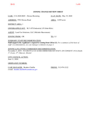
ZONING CHANGE REVIEW SHEET CASE: C14-2020-0045 – Dessau Rezoning Z.A.P. DATE: May 19, 2020 ADDRESS: 9701 Dessau Road AREA: 0.959 acres DISTRICT AREA: 1 OWNER/APPLICANT: SL5 ATX Industrial, LP (John Kiltz) AGENT: Land Use Solutions, LLC (Michele Haussmann) ZONING FROM: GR TO: LI SUMMARY STAFF RECOMMENDATION: Staff supports the Applicant’s request for zoning from GR to LI. For a summary of the basis of staff’s recommendation, see case manager comments on page 2. ZONING & PLATTING COMMISSION RECOMMENDATION: November 5, 2019: TO GRANT LI-CO AS RECOMMENDED BY STAFF, ON CONSENT. (9-0) [Smith- 1st, Evans- 2nd; Duncan- Absent] CITY COUNCIL ACTION: June 11, 2020: ORDINANCE NUMBER: CASE MANAGER: Heather Chaffin e-mail: heather.chaffin@austintexas.gov PHONE: 512-974-2122 B-031 of 6 C14-2020-0045 Page 2 ISSUES: The subject property is an undeveloped lot that is surrounded by an existing warehousing/distribution land use that was developed in the 1990s. CASE MANAGER COMMENTS: The subject property is located on east side of Dessau Road approximately 1/3-mile north of Rundberg Lane. The GR property is undeveloped and surrounded by Cameron Business Park, an industrial park occupied by a variety of commercial and limited industrial land uses. Tenants include medical equipment sales, custom manufacturing, and other uses. The industrial park is zoned LI and LI-CO. South of the rezoning property is land zoned GO-CO that is developed with religious assembly land use and land zoned LI-CO that is developed with another industrial park. Further south are properties zoned LR-CO, SF-3, LO and LI. Land uses on these properties include undeveloped, single family residential, religious assembly and commercial services. Further east is property outside Austin city limits that is developed with a mix of limited industrial uses along Brown Lane. To the north is I-RR land that is partially undeveloped and partially occupied by religious assembly land use. Further north is property that was rezoned from LI to MF-4 in 2018; the property has not yet been developed with multifamily land use. Across Dessau Road to the west is the Windsor Hills residential neighborhood which is zoned SF-3-NP. (Please see Exhibit A - Zoning Map). Staff supports the zoning request. LI zoning would allow the property to be developed with uses like the adjacent LI and LI-CO properties. The property is in an area with numerous limited industrial uses and is compatible with those neighboring properties. The proposed zoning should be consistent with the purpose statement of the district sought. BASIS OF RECOMMENDATION: 1. Limited industrial service (LI) district is the designation for a commercial service use or limited manufacturing use generally located on a moderately-sized site. Granting of the request should result in an equal treatment of similarly situated properties. 2. The limited industrial properties along Dessau have been rezoned since annexation to LI-CO and LI. Zoning should allow for reasonable use of the property. 3. Zoning the property would allow the existing development to make site and land use changes. It also allows the whole property to develop and change as a cohesive industrial park. EXISTING ZONING AND LAND USES: ZONING LAND USES GR Site North LI-CO, I-RR South LI, GR, LI-CO, GO-CO, East West SF-3, LO LI, LI-CO SF-3-NP Undeveloped Industrial park, Undeveloped, Religious assembly Industrial park- mixed commercial and industrial uses, Religious assembly, single family residential Mixed commercial and industrial uses Single family residential B-032 of 6 Page 3 C14-2020-0045 RELATED CASES: NUMBER C14-2019-0115 C14-2018-0126 Pioneer Hill Apartments REQUEST I-RR to LI- CO LI-CO to MF-4 COMMISSION 11/5/2019: To grant LI-CO (max 2,000 v.p.d.) 4/2/2018: to grant MF-4-CO, with max 600 d.u. CITY COUNCIL 12/5/2019: To grant LI-CO 5/9/2018: To grant MF-4 WATERSHED: Little Walnut Creek TIA: N/A NEIGHBORHOOD ORGANIZATIONS: Homeless Neighborhood Association Neighborhood Empowerment Foundation North Growth Corridor Alliance Windsor Hills Neighborhood Association Bike Austin SELTexas Heritage Hills/ Windsor Hills Neighborhood Plan Contact Team Austin Neighborhoods Council Friends of Austin Neighborhoods Harris Branch Master Association, Inc. AISD Sierra Club EXISTING STREET CHARACTERISTICS: Name ROW Pavement Classification Sidewalks Bicycle Route No ASMP Level 4 Yes 77’ Capital Metro (within ¼ mile) No Dessau Road 125’ OTHER STAFF COMMENTS Comprehensive Planning Connectivity - The Walkscore is 35/100, Car Dependent, meaning most errands require a car. There are public sidewalks located along both sides of Dessau Road. There are no public transit or bike lanes within 1/4 from the site. The mobility and connectivity options in the area are below average. Imagine Austin - The Imagine Austin Growth Concept Map identifies this project as being located along an Activity Corridor (Dessau Road). Activity Corridors are characterized by a variety of activities and types of buildings located along the roadway — shopping, restaurants and cafés, parks, schools, single- family houses, apartments, public buildings, houses of worship, mixed-use buildings, and offices. The following Imagine Austin policy is applicable to this case: LUT P4. Protect neighborhood character by directing growth to areas of change that includes designated redevelopment areas, corridors and infill sites. Recognize that different neighborhoods have different characteristics and new and infill development should be sensitive to the predominant character of these communities. Based on this property: (1) being situated along an Activity Corridor, which supports commercial uses, including office/warehouse uses; (2) having a large number of other light industrial and office/warehouses located within a quarter of a mile radius of this site; and (3) supporting the Imagine Austin policy referenced above that supports context sensitive infill while respecting the predominate character of the area, the proposed rezoning appears to support the Imagine Austin Comprehensive Plan. Site Plan SP1. Site plans will be required for any new development. SP2. Any development which occurs in an SF-6 or less restrictive zoning district which is located B-033 of 6 C14-2020-0045 Page 4 540 feet or less from property in an SF-5 or more restrictive zoning district will be subject to compatibility development regulations. SP3. Any new development is subject to Subchapter E. Design Standards and Mixed Use. Additional comments will be made when the site plan is submitted. SP4. FYI: Additional design regulations will be enforced at the time a site plan is submitted. SP5. The site is subject to compatibility standards due to proximity of SF-3-NP to west across Dessau Rd. and to SF-3 to the southeast. The following standards apply: No structure in excess of two stories or 30 feet in height may be constructed within 50 feet from the property zoned SF-5 or more restrictive. No structure in excess of three stories or 40 feet in height may be constructed within 100 feet from the property zoned SF-5 or more restrictive. For a structure more than 100 feet but not more than 300 feet from property zoned SF-5 or more restrictive, height limitation is 40 feet plus one foot for each 10 feet of distance in excess of 100 feet from the property zoned SF-5 or more restrictive. For a structure more than 300 feet but not more than 540 feet from property zoned SF- 5 or more restrictive, 60 feet plus one foot for each four feet of distance in excess of 300 feet from the property zoned SF-5 or more restrictive. An intensive recreational use, including a swimming pool, tennis court, ball court, or playground, may not be constructed 50 feet or less from property in an SF-5 or more restrictive zoning district. Transportation TR1. The traffic impact analysis for this site was waived because the TIA determination has been deferred until the Site plan application. TR2. A neighborhood traffic analysis was not required for this case because the site is accessing a Level 4 street per the ASMP. Existing Street Characteristics: Name ROW Pavement Classification Sidewalks Bicycle Route No ASMP Level 4 Yes 77’ Capital Metro (within ¼ mile) No Dessau Road 125’ Environmental 1. The site is not located over the Edwards Aquifer Recharge Zone. The site is located in the Little Walnut Creek Watershed of the Colorado River Basin, which is classified as an Urban Watershed by Chapter 25-8 of the City's Land Development Code. 2. Zoning district impervious cover limits apply in the Urban Watershed classification. 3. According to floodplain maps there is no floodplain within or adjacent to the project location. 4. Standard landscaping and tree protection will be required in accordance with LDC 25-2 and 25-8 for all development and/or redevelopment. 5. At this time, site specific information is unavailable regarding vegetation, areas of steep slope, or other environmental features such as bluffs, springs, canyon rimrock, caves, sinkholes, and wetlands. 6. This site is required to provide on-site water quality controls (or payment in lieu of) for all development and/or redevelopment when 8,000 s.f. cumulative is exceeded, and on site control for the two-year storm. B-034 of 6 C14-2020-0045 Page 5 Water and Wastewater WW1. The landowner intends to serve the site with City of Austin water and wastewater utilities. The landowner, at own expense, will be responsible for providing any water and wastewater utility improvements, offsite main extensions, utility relocations and or abandonments required by the land use. The water and wastewater utility plan must be reviewed and approved by Austin Water for compliance with City criteria and suitability for operation and maintenance. Depending on the development plans submitted, water and or wastewater service extension requests may be required. All water and wastewater construction must be inspected by the City of Austin. The landowner must pay the City inspection fee with the utility construction. The landowner must pay the tap and impact fee once the landowner makes an application for a City of Austin water and wastewater utility tap permit. INDEX OF EXHIBITS TO FOLLOW: A. Zoning Map B-035 of 6 ! ! ! MF-4 C14-2018-0126 ! ! ! ! ! ! ! ! ! ! ! ! ! ! ! ! ! C7A-03-007 ! ! ! I-RR C7A-03-010 ! ! ! ! ( ( ( ( T E A S D A LE T E R SF-3-NP B O N NIE B R A E SF-3-NP SF-3-NP ( ( C HIL ( SF-3-NP ( ( ( D R E S S D R ( ( ( ( SF-3-NP ( ( ( ( ( ( ( ( R LIN D FAY ( ( ( ( ( ( ( ( ( ( W E R N E ( SF-3-NP ( ( SF-3-NP ( ( M A N F O R ( ( ( ( ( ( D HILL D ( R ( SF-3-NP ( ( ( R H I L ( L D R ( ( ( ( ( ( ( ( ( ! ! ! GR-CO ! ! ! AR B O ! R SIDE D R ! ! GR-CO SF-6-CO MF-3-CO C7A-03-007 W H I T A K E R D R SF-6-CO ( ( ( ( ( ( ( ( ( ( ( ( ( ( ( ( ( ( ( ( ( ( ( ( ( ( ( ( SF-3-NP ( ! ! ! ! E ! D G E W O GR-CO ! ! ! R T H B N D C14T-03-0001.01 SF-6-CO SF-6-CO SF-6-CO SF-6-CO L A M P T O N L N LI-CO C14T-03-0001 C14T-03-0001.01 ( ( SPC94- 0196A SPC95 -0476C ! ! ! ! ! ! ! ! ( ( ( ( SF-3-NP ( ( ( ( ( ( ( ( ( ( ( D U R A S S E D ( ( G R E E N ( W I C ( H D R ( ( ( ( ( ( ( R AL D ( ( ( ( D N E K ( ( SP-94-0416C ! ! ! ! ! ! ! ! GR ! 83-231 ! ! ! ! ! ! ! ( ( ( C14-2010-0161 ( ( ( ( NP-2010-0028 ( ( ( ( ( MARSTON CIR ( ( ( R A M ( ( ( ( ( ( ( ( ( ( ( R H D G U O R O B L R A M ( ( ( ( ( SF-3-NP ( ( ( ( ( ( R X D A LIF A H ( ( ( ( ( ( ( ( ( SF-3-NP ( ( ( ( N N L O T S ( ( ( ( ( ( ( ( SF-3-NP ( ( ( TH CIR U O ( ( ( BRIGHTON LN ( ( SF-3-NP ( M N O M ( ( A PL T T VIS OIN P D O BIE D R SF-3-NP P OIN T VISTA PL SF-3-NP ( ( ( ( TA R TA N LN ( ( ( ( ( SF-3-NP ( ( ( SF-3-NP Y A N W E E D R E B A ( ( ( ( ( ( ( ( ( ( ( ( ( ( ( ( BRIG HTO ( ( N CIR ( ( ( ( ( ( AV E B U ( ( RY CIR ( ( P-NP P82-44 MF-3-NP A P A R T M 70-155 E N T S ( ( M A R L B O ( ( ( R O U G ( H CIR APA RTM E NTS 70-155 p83-098 MF-3-NP LI-CO C14-2019-0115 C7A-02-016 83-231 GO-CO 95-097 C14-83-231 PRIVATE SC H O OL LI 83-231 WHSE RETAIL SP-98-0135C C14-95-0097 SP96-0381C LI-CO 95-097 C14-95-0159 95-0159 C H U R C H LR-CO 95-0159 C14-2020-0009 ( SF-3 CHURCH LO SP85-136 79-149-RC SP-99-0033C SP-06-0133C SF-3 LI SP-04-0947C S. E S H W G A N LN D U N 76-96 CS-1-CO C14-01-0114 RENTAL SALES S E S U O H E R A W LI-CO C14-02-0186 MINI W H SES. LI SPC-02-0014A ( O. C. C ( E L E S P89-0050C PL U M BIN G S U P PLY 85-248 ( ZONING ZONING CASE#: C14-2020-0045 C O N C R E T E C O M P A N Y ( ( A U T O/S T O ( R A G E ( PAVIN G C O. ( N N L W O R B M H C O U N TY C O N S TR U CTIO O FFIC E N C O. A UT O S U P PLY ( 76-117 FE N C E S U PPLY 85-033 ( ( O FFIC E/W H S E 74-123 SF-3 85-169 ( SF-3 E R A Y C A D ( ( C H U R C H VA C A NT TA C O STA N D E R U N GR-MU-V-NP STO R E G A S\S T A TIO N GR ( ( ( CS OFFICE WHSE RZ85-075 D B E R G L N 7 5-2 1 C A R 60-143 GR-NP C14-2010-0160 R Z 8 6-4 3 MH-NP CS-CO C14-00-2156 00-2156 LI-NP SP95-0502C INDUSTRIAL\CENTER SP-99-2015C D R N O R E M A C ( ( LI C14-2014-0136 ( SUBJECT TRACT ! ! ! ! ! ! PENDING CASE ZONING BOUNDARY ± This product is for informational purposes and may not have been prepared for or be suitable for legal, engineering, or surveying purposes. It does not represent an on-the-ground survey and represents only the approximate relative location of property boundaries. 1 " = 400 ' This product has been produced by CTM for the sole purpose of geographic reference. No warranty is made by the City of Austin regarding specific accuracy or completeness. Created: 4/2/2020 B-036 of 6