B-02 (C14-2020-0015 - TechRidge Hotel a; District 1) — original pdf
Backup
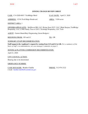
ZONING CHANGE REVIEW SHEET CASE: C14-2020-0015 TechRidge Hotel Z.A.P. DATE: April 21, 2020 ADDRESS: 12316 Tech Ridge Boulevard AREA: 5.036 acres DISTRICT AREA: 1 OWNERS/APPLICANTS: Bellflower RR, LLC; Rising Stars GUV, LLC; Bhatt Kunjan; TechRidge Hospitality, LLC; LWR Family Trust of 2015; Techridge Hospitality, LLC Tech AGENT: Garrett-Ihnen/Bieyl Engineering (Jason Rodgers) REZONING FROM: GO and LI TO: GR SUMMARY STAFF RECOMMENDATION: Staff supports the Applicant’s request for zoning from GO and LI to GR. For a summary of the basis of staff’s recommendation, see case manager comments on page 2. ZONING & PLATTING COMMISSION RECOMMENDATION: April 21, 2020: CITY COUNCIL ACTION: Hearing date to be determined ORDINANCE NUMBER: CASE MANAGER: Heather Chaffin e-mail: heather.chaffin@austintexas.gov PHONE: 512-974-2122 B-021 of 7 ISSUES: No issues at this time. The Applicants are requesting GR zoning to allow Hotel/motel land use. CASE MANAGER COMMENTS: The subject property is located at the northwest corner of Canyon Ridge Drive and Tech Ridge Boulevard. The southern portion of the rezoning area, approximately two-thirds, is zoned GO and the northern portion is zoned LI. The property is undeveloped. To the north are properties zoned LI that include personal improvement services land use. To the west are properties zoned LI, RR, and GR. These areas are undeveloped; the RR portion is floodplain. Northwest is a large commercial center zoned GR with retail, restaurant, and related uses. To the east, across Canyon Ridge Drive, is a Dell corporate campus. Across Tech Ridge Boulevard to the south and southeast are properties zoned GR and MF-4. These include undeveloped parcels and a Hotel/motel. (Please see Exhibits A and B- Zoning Map and Aerial Exhibit). The Applicant is proposing to develop the property with Hotel/motel land use. The traffic generation for the proposed development is required to comply with an existing Traffic Impact Analysis (TIA) that was previously prepared for the area. If the TIA needs to be revised to accommodate the vehicular trips of the proposed development, it will be required at time of site plan. Staff supports the proposed rezoning to GR. The property is roughly two-thirds GO zoning which does not permit Hotel/motel land use. As a property split with two disparate zoning classification, any development is challenging. The property is surrounded by GR, LI, LI-PDA, and MF-4; the GO zoning is the least intense commercial zoning in a wide area. The property is located approximately 3000 feet south of an Activity Center and very close to an intersection with Interstate 35 and Yager Lane, an Activity Corridor. BASIS OF RECOMMENDATION: 1. Zoning should allow for reasonable use of the property. Zoning should promote the policy of locating retail and more intensive zoning near the The property is currently zoned GO and LI. Development of a property with very different zoning classifications is very challenging. GR is somewhat a middle ground between GO and LI and will allow cohesive development. 2. intersections of arterial roadways or at the intersections of arterials and major collectors. The adjacent intersection of an arterial and major collector is an appropriate location for GR zoning. 3. GR is an appropriate zoning classification for a property surrounded by GR, LI, LI-PDA and MF-4 zoning. EXISTING ZONING AND LAND USES: Zoning changes should promote an orderly relationship among land uses. ZONING LAND USES GO, LI Site North LI South GR, MF-4 East LI-PDA Undeveloped Personal improvement services Undeveloped, Hotel/motel Corporate campus West GR, RR, LI, GO, LI-PDA Undeveloped B-022 of 7 RELATED CASES: NUMBER C14-2018-0063 12427 Tech Ridge Boulevard CITY COUNCIL 08/23/2018: To grant CS-CO as rec. by ZAP; Ord. No. 20180823-065 COMMISSION 07/17/2018: To grant with additional prohibited uses: Adult oriented bus., Construction sales & svs, REQUEST GR to CS-CO, prohibiting Ag. sales & svs, Campground, Elec. prototype assembly, Equip. repair svs, Food prep, Laundry svs, Plant nursery, Veterinary svs, Indoor crop production, Building maint. Svs, Comml blood plasma ctr, Elec. Testing, Equip sales, Kennels, Monument retail sales, Vehicle storage, Ltd warehousing & dist., Maint. & service facilities, Transitional housing, Transportation terminal LI to LI-PDA with 80’ height C14-2016-0014 211 Canyon Ridge Drive Hotel WATERSHED: Walnut Creek (Suburban) NEIGHBORHOOD ORGANIZATIONS: Homeless Neighborhood Association Friends of Austin Neighborhoods Sierra Club Neighborhood Empowerment Foundation North Growth Corridor Alliance Yager Planning Area EXISTING STREET CHARACTERISTICS: 05/03/2016: Forward without recommendation WITHDRAWN TIA: N/A SEL Texas Bike Austin Austin Neighborhoods Council Techridge Neighbors Friends of Copperfield Trails Pflugerville ISD Name ROW Pavement Classification Sidewalks Tech Ridge Blvd 140’ 100’ Canyon Ridge Dr OTHER STAFF COMMENTS 110’ (inc median) 55-70’ Arterial Collector Yes Yes Bicycle Route Yes, bike lane Yes, bike lane Capital Metro (within ¼ mile) Yes Yes Comprehensive Planning Imagine Austin- Tech Ridge Boulevard is not located in an Activity Center or along an Activity Corridor but a highly traveled arterial in this area. The following Imagine Austin policies are applicable to this case: LUT P3. Promote development in compact centers, communities, or along corridors that are connected by roads and transit that are designed to encourage walking and bicycling, and reduce health care, housing and transportation costs. B-023 of 7 LUT P4. Protect neighborhood character by directing growth to areas of change that includes designated redevelopment areas, corridors and infill sites. Recognize that different neighborhoods have different characteristics and new and infill development should be sensitive to the predominant character of these communities. LUT P7. Encourage infill and redevelopment opportunities that place residential, work, and retail land uses in proximity to each other to maximize walking, bicycling, and transit opportunities. Based on comparative scale of the other commercial uses in the area, including another hotel, and a variety of existing mobility options (public sidewalks, bike lanes, and bus stops), and a variety of connectivity options (retail and commercial uses) within walking distance of the subject property, this case supports the policies of the Imagine Austin Comprehensive Plan. Environmental 1. The site is not located over the Edwards Aquifer Recharge Zone. The site is in the Walnut Creek Watershed of the Colorado River Basin, which is classified as a Suburban Watershed by Chapter 25-8 of the City's Land Development Code. 2. to the following impervious cover limits: Under current watershed regulations, development or redevelopment on this site will be subject Development Classification % of Gross Site Area % of Gross Site Area Single-Family (minimum lot size 5750 sq. ft.) Other Single-Family or Duplex Multifamily Commercial 50% 55% 60% 80% with Transfers 60% 60% 70% 90% 3. According to floodplain maps there is no floodplain within or adjacent to the project location. 4. Standard landscaping and tree protection will be required in accordance with LDC 25-2 and 25-8 for all development and/or redevelopment. 5. At this time, site specific information is unavailable regarding vegetation, areas of steep slope, or other environmental features such as bluffs, springs, canyon rimrock, caves, sinkholes, and wetlands. 6. Under current watershed regulations, development or redevelopment requires water quality control with increased capture volume and control of the 2 year storm on site. Site Plan SP 1. Site plans will be required for any new development other than single-family or duplex residential. SP 2. Any development which occurs in an SF-6 or less restrictive zoning district which is located 540 feet or less from property in an SF-5 or more restrictive zoning district will be subject to compatibility development regulations. SP 3. Any new development is subject to Subchapter E. Design Standards and Mixed Use. Additional comments will be made when the site plan is submitted. SP 4. FYI: Additional design regulations will be enforced at the time a site plan is submitted. COMPATIBILITY STANDARDS SP 6. The site is subject to compatibility standards. Due to RR zoning to the northwest, the following standards apply: No structure may be built within 25 feet of the property line. B-024 of 7 No structure in excess of two stories or 30 feet in height may be constructed within 50 feet of the property line. No parking or driveways are allowed within 25 feet of the property line. A landscape area at least 25 feet wide is required along the property line. In addition, a fence, berm, or dense vegetation must be provided to screen adjoining properties from views of parking, mechanical equipment, storage, and refuse collection. For a structure more than 100 feet but not more than 300 feet from property zoned SF-5 or more restrictive, height limitation is 40 feet plus one foot for each 10 feet of distance in excess of 100 feet from the property zoned SF-5 or more restrictive. For a structure more than 300 feet but not more than 540 feet from property zoned SF-5 or more restrictive, 60 feet plus one foot for each four feet of distance in excess of 300 feet from the property zoned SF-5 or more restrictive. Transportation Sufficient right-of-way exists for both Tech Ridge Blvd. and Canyon Ridge Drive. A site plan must demonstrate compliance with the previous TIA approved with zoning case C14-85-322. The TIA may need to be amended depending on land uses and intensities submitted with site plan. Name Classification Sidewalks ROW Pavement Capital Metro (within ¼ mile) Yes Bicycle Route Yes, bike lane Yes, bike lane Tech Ridge Blvd 140’ Arterial Yes 110’ (inc median) 55-70’ Yes Yes 100’ Collector Canyon Ridge Dr Water and Wastewater WW1. The landowner intends to serve the site with City of Austin water and wastewater utilities. The landowner, at own expense, will be responsible for providing any water and wastewater utility improvements, offsite main extensions, utility relocations and or abandonments required by the land use. The water and wastewater utility plan must be reviewed and approved by Austin Water for compliance with City criteria and suitability for operation and maintenance. Depending on the development plans submitted, water and or wastewater service extension requests may be required. All water and wastewater construction must be inspected by the City of Austin. The landowner must pay the City inspection fee with the utility construction. The landowner must pay the tap and impact fee once the landowner makes an application for a City of Austin water and wastewater utility tap permit. INDEX OF EXHIBITS TO FOLLOW: A. Zoning Map B. Aerial Exhibit B-025 of 7 GR MF-4 SP-06-0123C C14-2012-0121 SP-05-1625C CS C14-96-0154 RR 85-322RC MC CALLEN PASS SP-03-0367C C14-98-0073 SP-00-2170CF 98-0073 SP-00-2170CF LI GR CS SP-05-1360C GR RR N 3 5 N B T O C A N Y O N R I D G E R A M P C14-88-0077 CS N I H 3 5 S V R D S B AIR COND. LI RR SP-05-1549C SP-00-2170CF SP-00-2170CF LI-PDA 98-0073 C14-96-0154 LI C14-96-0154 I R D E G D R N O Y N A C ! ! ! ! ! 96-0154 ! ! ! ! ! ! ! ! UNDEV ! GO ! ! ! ! ! ! ! GR N I H 3 5 S V R D N B GR SP-04-0308D 85-322 SP-02-0394D GR UNDEV SP-05-1663D SP97-0325C LO 85-149 IP MF-4 C14-2019-0010 89-0064 UNDEV N I H 3 N 5 I V S B H F 3 W 5 T N O B I H 3 5 N B R A M P GO EQUIPMENT SALES GR ± SUBJECT TRACT ! ! ! ! ! ! PENDING CASE ZONING BOUNDARY C14-92-0150(RCT) MF-3-CO C14-00-2150 90-008C SP94-0316C ZONING ZONING CASE#: C14-2020-0015 TECH RIDGE BLVD 85-322RC P 98-0067 C14-2018-0063 CS-CO LR 98-0 067 E YA 00-2150 G E R LN MF-2 SF-6 C14-85-339(RCA) C14-2008-0193 SF-6-CO SF-6-CO UNDEV LR 85-339RC MF-2 This product is for informational purposes and may not have been prepared for or be suitable for legal, engineering, or surveying purposes. It does not represent an on-the-ground survey and represents only the approximate relative location of property boundaries. 1 " = 400 ' This product has been produced by CTM for the sole purpose of geographic reference. No warranty is made by the City of Austin regarding specific accuracy or completeness. Created: 2/4/2020 B-026 of 7 CS CS GR CANYON RIDGE DR GR RR M34 MF-4 M C C ALLE N PASS GR RR LI LI-PDA N34 N33 GR C14-2020-0015 GO W YAGER LN TECH RIDGE BLVD M33 N I H 3 5 N N I B H 3 5 S B N I H 3 5 S V R D S B LO N I H 3 5 S V R D N B P A N F I R 3 K 5 R T S A M P H B I R T O T Y V F 3 W R 5 T A M N O B I P H GR I R D E G D R N O Y N A C GR P MF-4 CS-CO MF-3-CO E Y A G E R L N LR Copyright nearmap 2015 TECH RIDGE HOTEL C14-2020-0015 Creek Buffers ZONING BOUNDARY ZONING CASE#: LOCATION: SUBJECT AREA: GRID: MANAGER: C14-2020-0015 12316 TECH RIDGE BLVD. 5.036 Acres M33 Heather Chaffin This map has been produced by the Communications Technology Management Dept. on behalf of the Planning Development Review Dept. for the sole purpose of geographic reference. No warranty is made by the City of Austin regarding specific accuracy or completeness. IP ± 1'' = 300' B-027 of 7