Backup — original pdf
Backup
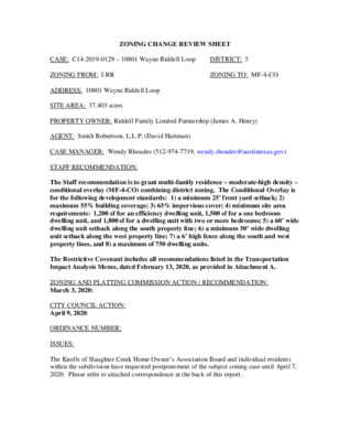
ZONING CHANGE REVIEW SHEET DISTRICT: 5 ZONING TO: MF-4-CO CASE: C14-2019-0129 – 10801 Wayne Riddell Loop ZONING FROM: I-RR ADDRESS: 10801 Wayne Riddell Loop SITE AREA: 37.403 acres PROPERTY OWNER: Riddell Family Limited Partnership (James A. Henry) AGENT: Smith Robertson, L.L.P. (David Hartman) CASE MANAGER: Wendy Rhoades (512-974-7719, wendy.rhoades@austintexas.gov) STAFF RECOMMENDATION: The Staff recommendation is to grant multi-family residence – moderate-high density – conditional overlay (MF-4-CO) combining district zoning. The Conditional Overlay is for the following development standards: 1) a minimum 25’ front yard setback; 2) maximum 55% building coverage; 3) 65% impervious cover; 4) minimum site area requirements: 1,200 sf for an efficiency dwelling unit, 1,500 sf for a one bedroom dwelling unit, and 1,800 sf for a dwelling unit with two or more bedrooms; 5) a 60’ wide dwelling unit setback along the south property line; 6) a minimum 50’ wide dwelling unit setback along the west property line; 7) a 6’ high fence along the south and west property lines, and 8) a maximum of 750 dwelling units. The Restrictive Covenant includes all recommendations listed in the Transportation Impact Analysis Memo, dated February 13, 2020, as provided in Attachment A. ZONING AND PLATTING COMMISSION ACTION / RECOMMENDATION: March 3, 2020: CITY COUNCIL ACTION: April 9, 2020: ORDINANCE NUMBER: ISSUES: The Knolls of Slaughter Creek Home Owner’s Association Board and individual residents within the subdivision have requested postponement of the subject zoning case until April 7, 2020. Please refer to attached correspondence at the back of this report. C14-2019-0129 Page 2 CASE MANAGER COMMENTS: The subject unplatted property contains one single family residence and zoned interim – rural residence (I-RR) district since its annexation into the City limits in December 1997. The tract has access to South First Street and the terminus of Wayne Riddell Loop. There are single family (detached) subdivisions to the west and south (SF-2, SF-1), Slaughter Creek flows through the north portion of the property (SF-2), and Akins High School is to east, across South First Street (MF-2). Please refer to Exhibits A (Zoning Map) and A-1 (Aerial View). Along the west property line, there is a 30-foot wide area owned by the Knolls of Slaughter Creek HOA that contains a gas pipeline easement and functions as a buffer area. As shown in Exhibit A-1, there are large groupings of trees at the southwest and south portion of the site as well as the north portion, the latter of which includes floodplain adjacent to Slaughter Creek. The Applicant proposes to rezone the property to the multifamily residence – moderate-high density – conditional overlay (MF-4-CO) district for the construction of up to 750 apartments. As listed on page 1, the Applicant’s requested Conditional Overlay limits development of the property to MF-3 development standards for the front yard setback, building coverage, impervious cover, and minimum site area requirements, as well as greater setbacks for dwelling units and fencing along the south and west property lines. BASIS OF RECOMMENDATION: 1. The proposed zoning should be consistent with the purpose statement of the district sought. The multi-family residence – moderate-high density (MF-4) district is intended for residential and multi-family use with a maximum density of up to 54 units per acre, depending on unit size and mix. This district is appropriate for multi-family residential areas located near supporting transportation and commercial facilities, generally in more centrally located areas. The Conditional Overlay (CO) combining district may be applied in combination with any base district. The district is intended to provide flexible and adaptable use or site development regulations by requiring standards tailored to individual properties. 2. Intensive multi-family zoning should be located on highways and major arterials. 3. Zoning changes should promote a balance of intensities and densities. Staff recommends the Applicant’s request for MF-4-CO zoning given its access to an arterial and a collector street, connectivity will be provided through the tract, thereby adding an access option for area residents, and additional buffers are provided between single family residences and proposed multifamily residences. Staff recommends the Applicant’s request for 60 feet given that the maximum height allowed by the MF-4 zoning district can be achieved at a distance of approximately 300 feet from the closest single family residences (Meadows at Double Creek Subdivision). C14-2019-0129 Page 3 The Traffic Impact Analysis memo recommends the extension of Wayne Riddell Loop from its terminus in the Knolls at Slaughter Creek subdivision to South First Street. The Wayne Riddell extension is shown in the Austin Strategic Mobility Plan adopted by Council in April 2019 and is consistent with a priority of the Imagine Austin Comprehensive Plan to create a compact and connected city. Please refer to Attachments A and B. EXISTING ZONING AND LAND USES: ZONING LAND USES Site North South I-RR SF-2 SF-2 West SF-1; SF-2 One single family residence Slaughter Creek Single family residences within the Meadows at Double Creek subdivision School Single family residences in the Knolls at Slaughter Creek subdivision East I-RR; MF-2-CO; MF-3-CO Apartments, Slaughter Creek; Austin ISD High SCENIC ROADWAY: No TIA: Is required – Please refer to Attachment A AREA STUDY: Not Applicable WATERSHEDS: Slaughter Creek / Onion Creek – Suburban CAPITOL VIEW CORRIDOR: No SCHOOLS: Menchaca Elementary School NEIGHBORHOOD ORGANIZATIONS: 627 – Onion Creek Homeowners Association 742 – Austin Independent School District 1228 – Sierra Club, Austin Regional Group 1307 – Oak at Twin Creeks Homeowners’ Association 1462 – Meadows at Double Creek POA 1530 – Friends of Austin Neighborhoods 1616 – Neighborhood Empowerment Foundation AREA CASE HISTORIES: 1531 – South Austin Regional Alliance (SANA) 1785 – Knolls of Slaughter Creek 1363 – SEL Texas 1528 – Bike Austin Akins High School Paredes Middle School NUMBER REQUEST COMMISSION CITY COUNCIL GR-MU-CO to P To Grant P C14-2013-0123 – Onion Creek Fire Station – 11112 Old San Antonio Rd Apvd P as Commission recommended (11-21- 2013). C14-2019-0129 Page 4 C14-2010-0027 – Colonial Grand at Cityway – 11001 South 1st St GR-MU-CO to MF-3 C14-05-0175 – Newmark Homes – Northwest corner of S First St and W FM 1626 I-RR to GR for Tract 1; SF-2 for Tract 2 C14-05-0014 – Harrell Tract – 9900 S First St I-RR to SF-2 I-RR to MF-2 C14-04-0125 – Harrell Tract 2 – 10000-10450 S First St C14-04-0124 – Harrell Tracts 1A and 1B – 10116 S IH-35 Service Rd SB; 9800 – 10000 S First St I-RR to GR-MU- CO for Tract 1A; CS-CO for Tract 1B To Grant MF-3-CO w/CO for limited access to Old San Antonio Rd., max. units of 430 and max. 5,753 trips/day, and conds of updated TIA To Grant GR-CO w/the CO for prohibited uses and SF-2 for Tract 2, and a Restrictive Covenant for the conds of the TIA and a private RC to prohibit the installation of video games To Grant SF-2 with a Restrictive Covenant for the conds of the TIA To Grant MF-2-CO w/the CO for MF-1 density, and a Restrictive Covenant for the conds of the TIA. To Grant GR-MU-CO for Tract 1A; CS-CO for Tract 1B with CO for prohibited uses, with a Restrictive Covenant for the conditions of the TIA and establishing a minimum square footage for restaurant uses. Apvd MF-3-CO w/conds as Commission recommended (5-27-2010). Apvd GR-CO for Tract 1 and SF-2 for Tract 2 with a Restrictive Covenant as Commission recommended (3-23-2006). Apvd SF-2 with a Restrictive Covenant for the conds of the TIA, as Commission recommended (5-12-2005). Apvd MF-2-CO, with a Restrictive Covenant for the TIA, as Commission recommended (12-2-2004). Apvd GR-MU-CO for Tract 1A and CS-CO for Tract 1B, with a Restrictive Covenant for the TIA and minimum square footage for restaurant uses, as Commission recommended (12-2-2004). RELATED CASES: The property was annexed into the City limits on December 31, 1997 (C7A-97-013). The subject zoning area occupies a central portion of the Preliminary Plan of Stablewood at Slaughter Creek, Revision No. 2, approved on April 11, 2001 (C8-95-0211.03). The zoning area is depicted with a single family residential lot layout and a recreation center, and Bicycle Route Capital Metro (within ¼ mile) Yes Bike Lane C14-2019-0129 Page 5 includes the extension of Wayne Riddell Loop to South First Street. If multifamily residence zoning is approved by Council, a change accounting for this land use must be addressed prior to approval of a final plat. Please refer to Exhibit B. There are no site plan cases on the subject property. EXISTING STREET CHARACTERISTICS: Name ROW Pavement ASMP Classification Sidewalks South 1st Street Wayne Riddell Loop 75 feet 120 – 130 feet 62 feet 40 feet Level 3 (Arterial, 4 lanes, Divided) No Level 2 (Neighborhood Collector) Yes No No OTHER STAFF COMMENTS: Comprehensive Planning The subject tract for this zoning case is located along an Imagine Austin Corridor (South 1st Street) and within one-half mile of the Imagine Austin Southpark Meadows Regional Center. The subject tract is 37.40 acres in size and contains one single family house. Surrounding uses includes undeveloped land and a single family subdivision to the north; to the south is a single family subdivision and an apartment complex; to the west is a single family subdivision; and to the east is Akins High School. The proposed use is a 750 unit multi- family apartment complex. Connectivity There are shared bike lanes adjacent to the subject tract located along South 1st Street but no public sidewalks. The adjoining single family subdivision to the west has public sidewalks. There are no public transit stops located within a half a mile of this property. All vehicular access to this property is currently from Wayne Riddell Loop, which is west of the property. The mobility options are below average while connectivity options are average (a public school across the street and shopping center being one-half mile away.) Imagine Austin The subject tract falls outside of the Imagine Austin designated Southpark Meadows Regional Center. Like many Imagine Austin Centers, this center is represented by a circle that reflects the general location where the center should be located in the future. The center’s actual boundaries would need to be clarified through a small area planning process. The project is also located along the South 1st Street Activity Corridor. Activity Corridors are intended to allow people to reside, work, shop, access services, people watch, recreate, C14-2019-0129 Page 6 and hang out without traveling far distances. They are characterized by a variety of activities and types of buildings located along the roadway — shopping, restaurants and cafés, parks, schools, single-family houses, apartments, public buildings, houses of worship, mixed-use buildings, and offices. The following Imagine Austin policies are applicable to this case: • LUT P3. Promote development in compact centers, communities, or along corridors that are connected by roads and transit that are designed to encourage walking and bicycling, and reduce health care, housing and transportation costs. • LUT P4. Protect neighborhood character by directing growth to areas of change that includes designated redevelopment areas, corridors and infill sites. Recognize that different neighborhoods have different characteristics and new and infill development should be sensitive to the predominant character of these communities. • LUT P5. Create healthy and family-friendly communities through development that includes a mix of land uses and housing types and affords realistic opportunities for transit, bicycle, and pedestrian travel and provides both community gathering spaces, parks and safe outdoor play areas for children. Conclusion: The Austin Strategic Housing Blueprint, which is an amendment to Imagine Austin, includes goals for affordable housing in every City Council district. Some of these goals include: (1) preventing households from being priced out of the Austin; (2) providing an affordable housing choice; and (3) protecting diverse communities. While this project does not have an affordable housing component, it will provide much needed workforce housing. Based on the subject tract’s location along an Activity Corridor but the lack of mobility options in the area, the proposed request partially supports the Imagine Austin Comprehensive Plan. C14-2019-0129 Page 7 C14-2019-0129 Page 8 Drainage 60% % of Gross Site Area % of Gross Site Area with Transfers 50% The developer is required to submit a pre- and post-development drainage analysis at the subdivision and site plan stage of the development process. The City’s Land Development Code and Drainage Criteria Manual require that the Applicant demonstrate through engineering analysis that the proposed development will have no identifiable adverse impact on surrounding properties. Environmental The site is not located over the Edwards Aquifer Recharge Zone. The site is in the Onion Creek and Slaughter Creek Watersheds of the Colorado River Basin, which is classified as a Suburban Watershed by Chapter 25-8 of the City's Land Development Code. The site is in the Desired Development Zone. Under current watershed regulations, development or redevelopment on this site will be subject to the following impervious cover limits: Development Classification Single-Family (minimum lot size 5750 sq. ft.) Other Single-Family or Duplex 55% 60% Multifamily Commercial 80% According to floodplain maps there is a floodplain within or adjacent to the project location. Based upon the location of the floodplain, offsite drainage should be calculated to determine whether a Critical Water Quality Zone exists within the project location.> Standard landscaping and tree protection will be required in accordance with LDC 25-2 and 25-8 for all development and/or redevelopment. At this time, site specific information is unavailable regarding vegetation, areas of steep slope, or other environmental features such as bluffs, springs, canyon rimrock, caves, sinkholes, and wetlands. Under current watershed regulations, development or redevelopment requires water quality control with increased capture volume and control of the 2 year storm on site. At this time, no information has been provided as to whether this property has any preexisting approvals that preempt current water quality or Code requirements. Site Plan and Compatibility Standards Site plans will be required for any new development other than single-family or duplex residential. 60% 70% 90% C14-2019-0129 Page 9 Any development which occurs in an SF-6 or less restrictive zoning district which is located 540 feet or less from property in an SF-5 or more restrictive zoning district will be subject to compatibility development regulations. Any new development is subject to Subchapter E. Design Standards and Mixed Use. Additional comments will be made when the site plan is submitted. FYI: Additional design regulations will be enforced at the time a site plan is submitted. The site is subject to compatibility standards due to adjacency of SF-1 to the west and SF-2 to the north, south and west. The following standards apply: • No structure may be built within 25 feet of the property line to the north, west, and south. • No structure in excess of two stories or 30 feet in height may be constructed within 50 feet of the property line to the north, west, and south. • No structure in excess of three stories or 40 feet in height may be constructed within 100 feet of the property line to the north, west, and south. • No parking or driveways are allowed within 25 feet of the property line to the north, west, and south. • Landscaping or screening is required along the north, west, and south property lines in accordance with the screening requirements (Section 25-2-1006 and ECM 2.9.1.), Parking Design Standards (Section 25-6-563) and/or Screening Standards (Section 25.2.1066) to screen adjoining properties from views of parking, mechanical equipment, storage, and refuse collection. • For a structure more than 100 feet but not more than 300 feet from property zoned SF-5 or more restrictive, height limitation is 40 feet plus one foot for each 10 feet of distance in excess of 100 feet from the property zoned SF-5 or more restrictive. • For a structure more than 300 feet but not more than 540 feet from property zoned SF-5 or more restrictive, 60 feet plus one foot for each four feet of distance in excess of 300 feet from the property zoned SF-5 or more restrictive. • An intensive recreational use, including a swimming pool, tennis court, ball court, or playground, may not be constructed 50 feet or less from property in an SF-5 or more restrictive zoning district. DEMOLITION AND HISTORIC RESOURCES The Applicant is responsible for requesting relocation and demolition permits once the site plan is approved. The City Historic Preservation Officer will review all proposed building demolitions and relocations prior to site plan approval. If a building meets city historic criteria, the Historic Landmark Commission may initiate a historic zoning case on the property. Transportation A traffic impact analysis is required and has been received. Additional right-of-way, participation in roadway improvements, or limitations on development intensity may be C14-2019-0129 Page 10 recommended based on review of the TIA [LDC 25-6-142]. Comments are provided in Attachment A. The Austin Strategic Mobility Plan (ASMP) adopted 04/11/2019, calls for 78 feet of right-of- way for Wayne Riddell Loop. It is recommended that 78 feet of right-of-way from the future centerline should be dedicated for Wayne Riddell Loop at the time of the subdivision and/or site plan application, whichever comes first [LDC 25-6-51 and 25-6-55]. Water and Wastewater FYI: The landowner intends to serve the site with City of Austin water and wastewater utilities. The landowner, at own expense, will be responsible for providing any water and wastewater utility improvements, offsite main extensions, water or wastewater easements, utility relocations and or abandonments required by the proposed land use. Depending on the development plans submitted, water and or wastewater service extension requests may be required. A wastewater SER has been approved for this site. Water and wastewater utility plans must be reviewed and approved by Austin Water for compliance with City criteria and suitability for operation and maintenance. All water and wastewater construction must be inspected by the City of Austin. The landowner must pay the City inspection fee with the utility construction. The landowner must pay the tap and impact fees once the landowner makes an application for Austin Water utility tap permits. INDEX OF EXHIBITS AND ATTACHMENTS TO FOLLOW: Exhibit A: Zoning Map Exhibit A-1: Aerial Map Exhibit B: Preliminary Plan of Stablewood at Slaughter Creek, Revision No. 2 Attachment A: Traffic Impact Analysis Memo Attachment B: Illustration of the Wayne Riddell Loop Extension Applicant’s Summary Letter Correspondence Received SF-2 SF-2 CAMPERDOWN ELM DR C14-05-0014 C14-04-0125 MF-2-CO SF-2 ( ( ( ( SF-1 ( ( ( ( ( SF-2 ( ( ( ( ( ( ( ( ( ( SF-1 ( ( ( ( SF-2 ( ( ( ( ( ( ( R D Y B R E D D R O L ( SF-1 ( A S S ( ( SF-2 ( ( ( ( ( ( SF-2 ( ( ( ( T R O P H ( Y P ( SF-2 ( ( ( ( ! ! ! ! ( ( ( ( TURF CV ( ( SF-2 ( ( ( ! ( ( ! ( ( 980326-L SF-1 ( ! ! ! ! ! ! ! ! ! C14-04-0124 T T S S S 1 ! ! ! ! ! ! ! ! ! ! SF-1 SF-2 P E D I G R E E D R ( ( ( ( SF-1 ( ( SF-1 ( ( ( ( SF-2 ( ( ( ( ( ( PEDIGREE CV ( ( SF-1 ( ! ! ( ( ! ! ! ( SF-2 ( ( ! ! ! ! ( SF-2 ( SF-1 ! ( ( ! ! ! I-RR ( UNDEV I-RR ! ! ! ! ! ! ! ! ! ! ! ! ! ! ! ! ! ! ! ( ( ( ( ! ! ! ! ! ! ! ( ( ( ( ( SF-2 ( DESERT WILLOW LOOP ( ( ( ( ! ( ( ( ( ( ( ( ( ( ( ( ( ( ( ( ( ( ( ( ( ( ( SF-2 ( ( ( ( ( ( ( ( ( ( ( ( ( ( ( ( ( C14-05-0175 ( ( ( ( ( ( ( ( ( SF-2 ( ( ( ( ( SPC-06-0388CS ( ( ! ( ( ! ( ! ! ! ! ( ( ( ( I-RR ( ( ( ( ( ( ( ( ( ( ( ( ( ( ( ( SF-2 ( ( ( ( POND ( ( ( ( ( ( ( ( ( C14-2010-0027 C14-06-0063 MF-3-CO 04-0018 ZONING Exhibit A ZONING CASE#: C14-2019-0129 ( ( ( ( ( ( ( ( SF-1 SF-2 SF-1 ( W AYNE RIDDELL LO OP ( SF-2 ( ( ( ( ( ( ( ( ( ( C O L O ( ( ( SF-1 ( ( ( ( ( ( SF-2 ( ( ( ( ( ( ( ( ( ( ( ( ( ( ( MINT JULEP DR ( ( SF-2 ( ( N E ( IN W L ( ( ( ( ( N L O O ( P ( ( SF-4A ( ( ( SF-2 ( ( ( ( ! ( ( ( ( ( ( ( ( ! ! ( ( ( ( ( ( ( ( ! ! ! ! ! ! ( ( ( ( SF-1 ( ( ( ( ( ( ( ( ( ( ± ( ( ( I-RR SF-2 ( ( ( ( SF-2 ( V I S A R O S E D R ( SF-2 ( ( ( ! ! ! ! ! SUBJECT TRACT ! PENDING CASE ZONING BOUNDARY This product is for informational purposes and may not have been prepared for or be suitable for legal, engineering, or surveying purposes. It does not represent an on-the-ground survey and represents only the approximate relative location of property boundaries. 1 " = 400 ' This product has been produced by CTM for the sole purpose of geographic reference. No warranty is made by the City of Austin regarding specific accuracy or completeness. Created: 9/30/2019 HIGH SCHOOL C14-2014-0077 I D R O N O T N A N A S D L O C14-03-0053 79 21 22 12 11 37 38 13 23 24 25 26 C A M P E R D 10 9 27 8 7 O W 28 N E L SF-2 31 32 M D R 5 3 6 4 2 1 41 42 43 40 M V E K C L A S A O 5 4 3 2 1 33 35 34 36 12 11 10 9 8 6 7 5 4 2 3 1 21A 4 MF-2-CO 25 80 78 24 T T S S S 1 SF-2 128 129 130 131 132 133 122 121 120 119 SF-1 124 SF-2 125 123 8 7 SF-1 TH O R O U G HBRED D R 14 15 16 13 5 3 2 137 136 135 134 TURF CV SF-2 138 139 140 5 6 7 4 2 9 1 145 141 146 147 8 R D Y D R 151 LO B R E D SF-1 148 149 160 115 114 113 SF-2 110 3 SF-1 F12 105 SF-2 101 107 108 SF-1 SF-1 98 97 96 100 102 P E D I G R E E D R 5 SF-2 4 3 1 2 9 10 11 SF-1 60 13 25 WAYNE RI DDELL LOOP SF-2 161 69 70 O CT 71 72 74 73 77 78 SEA HER 75 SF-2 60 61 63 67 68 65 26 27 1 2 3 4 C A 19 18 17 16 15 14 21 22 23 24 79 SF-1 80 81 S E A H 10 9 SF-1 5 4 RIS LN E R O L 2 N M A TIC 94 83 84 85 89 86 87 82 SF-2 32 31 30 1A 13 12 11 10 9 1 8 29 28 3 25 SF-1 11 10 8 26 7 6 4 5 R A C E T R A C K 30 D R 29 SF-1 34 35 22 36 27 26 25 24 2 3 5 10 31 32 39 38 37 14 15 18 17 4 19 93 25 21 20 22 28 26 SF-2 17 1 2 3 24 23 22 C OLO NEL WIN N LO O P MINT JULEP DR 5 6 20 19 18 44 45 42 43 15 14 13 8 9 SF-2 15 14 SF-2 3 2 52 53 4 55 54 46 47 48 SF-2 51 23 22 21 19 7 6 1 7 4 1 59 56 58 8 SF-2 I-RR C14-2019-0129 33 35 34 36 SF-1 29 37 38 39 40 58 T S T S 1 S 25 24 26 27 29 28 SF-2 35 34 36 37 39 38 DESERT WILLOW LOOP 40 5 4 3 6 2 7 29 1 8 9 28 SF-2 26 24 14 23 15 21 20 17 19 15 ROSE MALLOW WAY 20 18 16 17 14 3 2 1 SF-2 18 5 19 DESERT 14 PRIMROSE DR 12 13 41 42 43 44 18 46 45 I-RR 47 48 49 50 51 52 55 53 54 I-RR 21 20 J O C K E Y B L U F F D R 14 13 12 9 11 17 14 13 12 SF-2 9 8 SF-1 SF-4A 18 SF-2 W FM 1626 RD 16 17 26 19 18 19 16 15 SF-2 4 5 E N Y A W L L E D ID R P O O L 13 12 11 10 9 8 7 6 5 SF-2 16 15 21 24 27 26 MORNING PRIMROSE CT 8 9 10 11 7 6 4 12A 5 3 56 1 1 2 13 GR-CO 2 4 3 2 1 I-RR D NIO R O T N N A A D S I-RR L O A LO-MU-CO I-RR B SF-2 GR-CO CS-MU-CO 1 MF-3-CO I-SF-4A 75 I-RR A 2 GR-MU-CO P Copyright nearmap 2015 ± 1'' = 500' SUBJECT TRACT ZONING BOUNDARY ! ! ! ! ! ! PENDING CASE CREEK BUFFER 10801 WAYNE RIDDELL LOOP Exhibit A -1 ZONING CASE#: LOCATION: SUBJECT AREA: GRID: MANAGER: C14-2019-0129 10801 WAYNE RIDDELL LOOP 37.403 Acres F12 Wendy Rhoades This map has been produced by the Communications Technology Management Dept. on behalf of the Planning Development Review Dept. for the sole purpose of geographic reference. No warranty is made by the City of Austin regarding specific accuracy or completeness. Exhibit B MEMORAN DUM Date: To: CC: Reference: February 13, 2020 Wendy Rhoades, Case Manager Dan Hennessey, P.E. Curtis Beatty, P.E. Amber Mitchell Joan Jenkins, EIT South 1st Street Apartments – TIA Final Memo (C14-2019-0129) Summary of the Transportation Impact Analysis (TIA): The Austin Transportation Department (ATD) has reviewed the December 31, 2019 (received January 2, 2020) “South 1st Street Apartments Transportation Impact Study”, prepared by WGI. The proposed land use consists of 750 dwelling units of mid-rise multi- family. The development will be located on the west side of South 1st Street across from Akins High School, in south Austin, and is anticipated to be completed in two phases. Phase 1 and Phase 2 have estimated build-out years of 2021 and 2023, respectively. The following is a summary of the review findings and recommendations: 1. A fee in-lieu contribution to the City of Austin shall be made for the sidewalk improvement identified in Table 2, totaling $55,500, as a condition of approval for the zoning application. Please see attached invoice (Exhibit A). 2. The applicant shall design and construct the improvements identified in Table 2. Improvements to be built by the applicant should be included with the site plan or subdivision construction set. No temporary certificate of occupancy (TCO) or certificate of occupancy (CO) shall be issued until the construction of the identified improvements is complete. Note: With the exception of the traffic signal installation, cost estimates should not be assumed to represent the maximum dollar value of improvements the applicant may be required to construct. 3. Development of this property should not vary from the approved uses or deviate from the approved intensities and estimated traffic generation assumptions within the finalized TIA document, including land uses, trip generation, trip distribution, traffic controls, driveway locations, and other identified conditions. Any change in the assumptions made to the TIA document shall be reviewed by ATD and may require a new or updated TIA/addendum. 4. Two copies of the final TIA are required to be provided prior to the approval of the zoning application. One should be delivered to ATD and one to DSD. Attachment A Page 1 of 5 5. The findings and recommendations of this TIA memorandum remain valid until five (5) years from the date of this memo, after which a revised TIA or addendum may be required. Site Location and Existing Conditions: The site is expected to be developed in two phases: Phase 1 on the north side of the future Wayne Riddell Loop extension and Phase 2 on the south side. Both phases will take access to South 1st Street and the future Wayne Riddell Loop extension. The driveways on Wayne Riddell Loop will be full access, while the driveways on South 1st Street will allow inbound access from both northbound and southbound directions but only right-turn movements for outbound vehicles. Assumptions: 1. The following reductions were applied for this development: Active Modes and Transit (10% AM & PM) 2. Based on TxDOT AADT volume data, a three (3) percent annual growth rate was assumed to account for the increase in background traffic. 3. Below are the background projects that were assumed to contribute trips to surrounding roadway network in addition to forecasted traffic for 2023: Mercedes-Benz of South Austin Star Furniture South Conroy Warehouses Double Creek Retail Austin Onion Creek Fire & EMS Station Proposed Conditions: Trip Generation and Land Use Based on the Institute of Transportation Engineers (ITE) Trip Generation Manual (10th Edition) and the trip reductions mentioned above, the development would generate approximately 3,661 adjusted average daily trips (ADT) upon final build-out. Table 1, below, shows the trip generation by land uses for the proposed development. Proposed Land Use (ITE Code) Size 24-Hour Two Way Volume AM Peak Hour PM Peak Hour Enter Exit Enter Exit 375 DU 1,823 30 85 90 57 375 DU 1,838 90 91 57 3,661 175 181 114 31 61 Phase 1: Multi-family Housing (Mid-Rise) (221) Phase 2: Multi-family Housing (Mid-Rise) (221) Total Page 2 of 5 Summary of Recommended Improvements The applicant shall dedicate 68’ of ROW across the property to accommodate the extension of Wayne Riddell Loop as shown in the Austin Strategic Mobility Plan (ASMP). In addition, the applicant shall design and construct the Wayne Riddell Loop extension from its current terminus to South 1st Street. The design intent is for a full three-lane cross-section from South 1st Street to the project driveways, after which the cross-section shall taper to match the existing Wayne Riddell Loop cross-section. The proposed cross-section shall consist of two 5-ft sidewalks, two 2-ft buffer zones, two 7-ft bike lanes with 2-ft buffers, and three 12- ft lanes, for a total width of 68’. Two 2-ft easements will be required on either side for sidewalk maintenance. Coordination with applicable City departments shall be required for the design of the extension. As part of the Wayne Riddell Loop extension, the applicant shall design and install a traffic signal at the intersection of Wayne Riddell Loop and South 1st Street. The Arterial Management Division (AMD) will be responsible for the approval and operation of the traffic signal. To improve bicycle safety and connectivity near the project site, the applicant shall upgrade the existing buffered bike lanes to delineator-separated protected bike lanes on both sides of South 1st Street adjacent to the property. As mitigation for this development, the applicant shall also make a $55,500 fee in-lieu payment to the City to provide sidewalk connection from the south property line to the existing sidewalk north of Desert Primrose Drive. Table 2: Recommended Improvements and Developer’s Share Location Improvement Developer Requirement Wayne Riddell Loop Extension Wayne Riddell Loop Extension Dedicate ROW and Sidewalk Easements Construct Wayne Riddell Loop extension (three-lane cross- section) and associated pedestrian elements Dedicate as part of site plan or subdivision construction set Estimated Cost $56,214 Construct as part of site plan or subdivision construction set $920,455 Wayne Riddell Loop/South 1st Street Install traffic signal Construct as part of site plan or subdivision construction set $300,000 South 1st Street South 1st Street Convert buffered bike lanes to delineator-separated protected bike lanes Construct sidewalk from south property line to existing sidewalk north of Desert Primrose Drive Construct as part of site plan or subdivision construction set $12,000 Fee in-lieu payment to City $55,500 Total $1,344,169 Page 3 of 5 If you have any questions or require additional information, please feel free to contact me at 512-974-1449. Justin Good, P.E. Austin Transportation Department Page 4 of 5 EXIBIT A INVOICE TRANSPORTATION MITIGATION FEE IN-LIEU DATE: February 13, 2020 TO: CC: Dan Hennessey, P.E. (WGI) Alyssa Gutierrez (ATD Cashier) 901 S. Mopac Expressway, Bldg 5, Suite 300, Austin TX 78746 FROM: Justin Good, P.E. Austin Transportation Department AMANDA CASE#: C14-2019-0129 (South 1st Street Apartments) FDU: 8401-2507-1103-4163 As a condition of approval for the zoning application referenced above, the applicant shall post a transportation mitigation fee with the City of Austin in the amount of $55,500 as listed in the TIA Final Memo in accordance with LDC. If you have any questions, please contact me at (512) 974-1449. Office Use only: Check: Received by: Page 5 of 5 Attachment B ONIONCREEKPKWYRACETRACKDRCONROYLNOLDSANANTONIORDWFM1626RDASHTREECTTEXASASHCVMINTJULEPDRPEDIGREECVSALEMOAKCVHILLHOUSELNTROPHYCVGRAZINGHORSELNLORDDERBYDRDESERTWILLOWLOOPASHBROOKDRBIRLANDIERCTGRIZZLYOAKDRPEDIGREEDRCARISMATICLNCAMPERDOWNELMDRDESERTPRIMROSEDRTURFCVJOCKEYBLUFFDRAUTUMNASHDRCLUBHOUSETURNDRENGLISHOAKDRTROPHYPASSVISAROSEDRHOGGPECANPASSHILLSTABLECTEFM1626RDMORNINGPRIMROSECTKARENHILLPLTHOROUGHBREDDRS1STSTROSEMALLOWWAYS1STSTS 1ST STFARRAHLNCOLONELWINNLOOPANACUALOOPWAYNERIDDELLLOOPWayne Riddell Loop Extension as adopted in the ASMP¯ASMP Street Table00.150.30.07MilesAkinsHighSchoolLegendExisting Right-of-Way (ROW)TCAD ParcelsWayne Riddell Loop (Connection - New Road)Wayne Riddell Loop (Existing Road)This map has been produced by the Planning Development ReviewDepartment for the sole purpose of geographic reference. No warrantyis made by the City of Austin regarding specific accuracy orcompleteness. Applicant's Summary Letter Correspondence Received