B-07 (SP-2019-0108D - Thaxton Road Tract Offsite Wastewater Improvements; District 2).pdf — original pdf
Backup
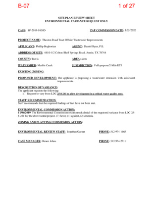
SITE PLAN REVIEW SHEET ENVIRONMENTAL VARIANCE REQUEST ONLY CASE: SP-2019-0108D ZAP COMMISSION DATE: 3/03/2020 PROJECT NAME: Thaxton Road Tract Offsite Wastewater Improvements APPLICANT: Phillip Boghosian AGENT: Daniel Ryan, P.E. ADDRESS OF SITE: 6810-1/2 Colton Bluff Springs Road, Austin, TX 78744 COUNTY: Travis AREA: acres WATERSHED: Marble Creek JURISDICTION: Full-purpose/2-Mile ETJ EXISTING ZONING: PROPOSED DEVELOPMENT: The applicant is proposing a wastewater extension with associated improvements. DESCRIPTION OF VARIANCE: The applicant requests the following: 1. Request to vary from LDC 25-8-261 to allow development in a critical water quality zone. STAFF RECOMMENDATION: Staff recommends that the required findings of fact have not been met. ENVIRONMENTAL COMMISSION ACTION: 11/06/2019: The Environmental Commission recommends denial of the requested variance from LDC 25- 8-261 for the above noted project. (7) favor, (1) against, (2) absentia ZONING AND PLATTING COMMISSION ACTION: ENVIRONMENTAL REVIEW STAFF: Jonathan Garner PHONE: 512-974-1665 CASE MANAGER: Renee Johns PHONE: 512-974-2711 B-071 of 27 ENVIRONMENTAL COMMISSION MOTION 20191106 008b Date: November 6, 2019 Subject: Thaxton Road Tract Offsite Wastewater Improvements, SP-2019-0108D Motion by: Ryan Nill Seconded by: Peggy Maceo RATIONALE: WHEREAS, the Environmental Commission recognizes the proposed applicant is requesting a variance from LDC 25-8-261 to allow development within a Critical Water Quality Zone; and WHEREAS, the Environmental Commission recognizes that City of Austin Staff does not recommend this variance, having determined that the findings of fact have not been met. THEREFORE, the Environmental Commission recommends denial of the requested variance from LDC 25- 8-261 for the above noted project; however, should the Land Use Commission move to approve the variance, the Environmental Commission recommends the following conditions be considered: 1. For the proposed wastewater line, access roads shall be minimized to the maximum extent practicable within the critical water quality zone, including during time of construction or future maintenance. 2. For the proposed wastewater line, the utility alignment crossing the creek shall bore under the creek and encase the line, and the bore and receiving pits shall be located outside of the erosion hazard zone. 3. For the proposed wastewater line, no amount of the stabilized construction entrances shall be located within 150’ of the creek centerline. 4. The waste water line shall be encased within all areas of the inner half of the Critical Water Quality Zone. The developer shall provide riparian revegetation for all areas in the inner half of the Critical Water Quality Zone and erosion hazard zone. The developer shall avoid placement of manholes in the inner half of the Critical Water Quality Zone where feasible. For the proposed wastewater line, access roads shall be minimized to the maximum extent practicable within the Critical Water Quality Zone, including during time of construction or future maintenance. For the proposed wastewater line, the utility alignment crossing the creek should be bored under the creek and encased and the bore and the receiving pits shall be located outside the erosion hazard zone. For the proposed wastewater line, no amount of stabilized construction entrance shall be located within 150 feet of the creek centerline. 10. The existing eight-inch line shall be connected to proposed thirty-inch wastewater line prior to completion of construction and the remainder of the eight-inch line be abandoned in place. 5. 6. 7. 8. 9. 1 B-072 of 27 Staff Findings of Fact and Exhibits B-073 of 27 Development Services Department Staff Recommendations Concerning Required Findings Project Name: SP-2019-0108D Thaxton Road Tract Offsite Wastewater Improvements Ordinance Standard: Watershed Protection Ordinance Variance Request: To allow development in a Critical Water Quality Zone Include an explanation with each applicable finding of fact. A. Land Use Commission variance determinations from Chapter 25-8-41 of the City Code: 1. The requirement will deprive the applicant of a privilege available to owners of similarly situated property with approximately contemporaneous development subject to similar code requirements. No. The wastewater line is proposed within a dedicated easement that was not reviewed and approved by environmental review staff of the Development Services or Watershed Protection Departments prior to dedication. The proposed wastewater line would encroach into the erosion hazard zone and an area that is less than the minimum 150 feet setback from the center line of the adjacent major waterway (Marble Creek). An easement dedication does not guarantee the right to construct a utility otherwise prohibited by the Land Development Code. 2. The variance: a) Is not necessitated by the scale, layout, construction method, or other design decision made by the applicant, unless the design decision provides greater overall environmental protection than is achievable without the variance; No. Alternative alignments that would not encroach into the minimum setback of the critical water quality zone exist. However, the applicant intends to take advantage of an already dedicated easement and provide a gravity-fed wastewater line, rather than dedicate a new easement within the right-of-way and provide a force main line with lift stations, as needed. As proposed, the wastewater line will result in permanent alteration of the critical water B-074 of 27 quality zone and does not provide greater overall environmental protection because of the potential for leaks and breaks in the line resulting in sewage overflows into clean-flowing creeks. b) Is the minimum deviation from the code requirement necessary to allow a reasonable use of the property; No. There are alternative locations for the wastewater line and access road that would not necessitate a variance. c) Does not create a significant probability of harmful environmental consequences. No. As currently designed, the proposed wastewater line construction intends to bore under the critical water quality zone and the erosion hazard zone, with an overall approximate average depth of 8-12 feet, resulting in disturbance to subsurface hydrology and removal of native soils. The proposed wastewater line will require future repairs from eventual breaks and sewage overflows, which will require trenching to repair the line that equates to removal of riparian vegetation and disturbance to hydrologic functions. 3. Development with the variance will result in water quality that is at least equal to the water quality achievable without the variance. N/A. Water quality treatment is not required for a subsurface utility line. B. The Land Use Commission may grant a variance from a requirement of Section 25- 8- 422 (Water Supply Suburban Water Quality Transition Zone), Section 25-8-452 (Water Supply Rural Water Quality Transition Zone), Section 25-8-482 (Barton Springs Zone Water Quality Transition Zone), Section 25-8-368 (Restrictions on Development Impacting Lake Austin, Lady Bird Lake, and Lake Walter E. Long), or Article 7, Division 1 ( Critical Water Quality Zone Restrictions ), after determining that:: 1. The criteria for granting a variance in Subsection (A) are met; Staff has made the determination that because an alternative route and method of construction are available to provide wastewater utility service, the proposed location of the wastewater utility within the minimum setback of a Critical Water Quality Zone and the erosion hazard zone does not meet the criteria for granting a variance in Subsection A. No. 2. The requirement for which a variance is requested prevents a B-075 of 27 reasonable, economic use of the entire property; No. There are viable alternatives to the proposed design. 3. The variance is the minimum deviation from the code requirement necessary to allow a reasonable, economic use of the entire property. No. There are viable alternatives to the proposed design that would not require a variance. Staff Determination: Staff determines that the findings of fact have not been met. Environmental Reviewer (DSD) Jonathan Garner Environmental Review Manager (DSD) Mike McDougal Date 10-30-2019 Date 10-30-2019 Environmental Officer (WPD) ____________________________ Chris Herrington, P.E. Date ________________ 10-31-2019 B-076 of 27 Applicant Form and Findings of Fact B-077 of 27 September 18, 2019 ENVIRONMENTAL COMMISSION VARIANCE APPLICATION FORM PROJECT DESCRIPTION Applicant Contact Information Name of Applicant Street Address City State ZIP Code Work Phone E-Mail Address Case Name Case Number Address or Location Environmental Reviewer Name Environmental Resource Management Reviewer Name Applicable Ordinance Philip Boghosian 7316 N. Hulbert Fresno, California 93711 SP-2019-0108D 9000-10423 Thaxton Road Jonathan Garner Variance Case Information Thaxton Road Tract Offsite Wastewater Improvements Springfield Accommodation Agreement (Attached 245) Watershed Name Marble Creek Watershed Classification ☐Urban ☐ Suburban ☐Water Supply Suburban ☐Water Supply Rural ☐ Barton Springs Zone City of Austin | Environmental Commission Variance Application Guide 1 B-078 of 27 September 18, 2019 Edwards Aquifer Recharge Zone ☐ Barton Springs Segment ☐ Northern Edwards Segment ☐ Not in Edwards Aquifer Zones Edwards Aquifer Contributing Zone Distance to Nearest Classified Waterway ☐ Yes ☐ No 50 Feet at Closest Point on Alignment Water and Waste Water service to be provided by Austin Water Utility Request The variance request is to allow a utility parallel to and within the critical water quality zone within 150 feet from the centerline of a major waterway (25-8-261 (E)). Impervious cover Existing square footage: ___N/A_____ ________ ________ Proposed ____N/A_____ _________ _________ The property slopes between 0 and 10% generally. Elevations range from 648 ft to 578 ft above MSL. The subject site is located within the Blackland Prairie ecological area of Texas and the Live Oak-Mesquite-Ashe Juniper Parks vegetational area of Texas. The subject site is dominated by woodland and rangeland species. The woodland species include honey mesquite, sugarberry, and ashe juniper while the grassland species include ragweed, johnsongrass, bluebonnet, and Texas prickly pear. The geology of the site is composed of Fluviatile terrace deposits (Qt) and the Ozan Formation (Ko). These are composed of gravel, sand, silt and clay in various proportions. The site runs along Marble Creek which is a suburban watershed and does not encroach on any wetland CEFs. The alignment is located within the CWQZ of Marble Creek. The alignment crosses the 100 year fully developed floodplain. acreage: percentage: Provide general description of the property (slope range, elevation range, summary of vegetation / trees, summary of the geology, CWQZ, WQTZ, CEFs, floodplain, heritage trees, any other notable or outstanding characteristics of the property) City of Austin | Environmental Commission Variance Application Guide 2 B-079 of 27 September 18, 2019 Project: Ordinance: A. Clearly indicate in what way the proposed project does not comply with current Code (include maps and exhibits) The project includes a section of gravity wastewater line proposed with an existing easement that is located parallel to and within the CWQZ within 150 feet of a major waterway, which is not allowed under 25-8-261 (E) of the Land Development Code. Please find attached exhibits documenting proposed variance. FINDINGS OF FACT As required in LDC Section 25-8-41, in order to grant a variance the Land Use Commission must make the following findings of fact: Include an explanation with each applicable finding of fact. Land Use Commission variance determinations from Chapter 25-8-41 of the City Code: 1. The requirement will deprive the applicant of a privilege available to owners of similarly situated property with approximately contemporaneous development subject to similar code requirements. Yes. The prohibition on construction of the wastewater line within the half critical water quality zone would mean the project would not be able to use the easement previously obtained by the City of Austin Water Utility for the purpose of installing this wastewater line. The Springfield subdivision was required to grant the easement in lieu of constructing this line. The City of Austin reviewed and accepted the easement knowing its location in relation to the centerline of the creek. In addition, the Springfield subdivision was previously allowed to construct a wastewater line within the exact same area as the area proposed. See also note on the applicability of the Accommodation Agreement by Mr. Jeff Howard on the attached letter. 2. The variance: a) Is not necessitated by the scale, layout, construction method, or other design decision made by the applicant, unless the design decision provides greater overall environmental protection than is achievable without the variance; Yes, the variance requested is not based on a condition caused by the method City of Austin | Environmental Commission Variance Application Guide 3 B-0710 of 27 September 18, 2019 chosen by the applicant. The proposed wastewater line location is the location established by the Austin Water Utility in an approved, and unexpired service extension request (see attached). There is an existing easement previously approved and accepted by the City of Austin being used for the location of the line. In addition, the development method does provide greater environmental protection than is achievable without the variance as a lift station in very close proximity to the creek would be required without that variance. In addition, the alternative would require an easement from the adjoining landowner, and no such easement has been obtained to date, and there is no means to require that such adjoining landowner provide such an easement. Is the minimum deviation from the code requirement necessary to allow a reasonable use of the property; Yes, the variance requested is the minimum change necessary to allow for development of the property. Gravity wastewater service is necessary for the safe and orderly development of not only this tract but the entire upstream watershed. Does not create a significant probability of harmful environmental consequences. Yes, the proposed variance does not create a significant probability of harmful environmental consequences. In addition to being located above the bank of the creek on the high side, and adjacent to existing development, which minimizes the additional impact, the applicant proposes to bore and encase the pipe through the zone of encroachment to the maximum extent possible. 3. Development with the variance will result in water quality that is at least equal to the water quality achievable without the variance. Yes, the proposed project will result in equal water quality at a minimum. No disturbance of riparian areas is proposed, and the line will be encased through the section of encroachment. Moreover, this proposed alignment does not require a lift station which is considered more vulnerable to wastewater overflows due to mechanical failure or power outages. Additional Land Use Commission variance determinations for a requirement of Section 25-8-422 (Water Quality Transition Zone), Section 25-8-452 (Water Quality Transition Zone), Article 7, Division 1 (Critical Water Quality Zone Restrictions), or Section 25-8-368 (Restrictions on Development Impacting Lake Austin, Lady Bird Lake, and Lake Walter E. Long): 1. The criteria for granting a variance in Subsection (A) are met; City of Austin | Environmental Commission Variance Application Guide 4 b) c) B. B-0711 of 27 September 18, 2019 2. Yes, for the reasons provided above. The requirement for which a variance is requested prevents a reasonable, economic use of the entire property; Yes, if the alignment approved with the original easement is not allowed the reasonable use of the property is prevented. A lift station, force main, and disturbance to existing public facilities, including existing subdivision streets, significantly greater than what is required for the approved easement would be required, at a significantly higher cost to the applicant and the City of Austin and impact to existing public streets, neighborhoods and residents. 3. The variance is the minimum deviation from the code requirement necessary to allow a reasonable, economic use of the entire property. Yes, the proposed alignment of the wastewater line is the minimum necessary change to allow for the reasonable economic use of the property and reasonable mitigation of the impacts is being proposed. **Variance approval requires all above affirmative findings. City of Austin | Environmental Commission Variance Application Guide 5 B-0712 of 27 B-0713 of 27 B-0714 of 27 B-0715 of 27 Applicant Exhibits B-0716 of 27 SHEET 6 2 4 5 540 538 536 WW 5 2 2 534 5 3 2 5 2 2 5 2 4 526 542 0 4 7 1 7 0 6 1 0 C # 2 O T D N E M E S A L E W W 1 4 7 1 7 0 6 1 0 C # 2 O T D N E M E S A L E W W 544 540 538 536 SHEET 7 WWL EASEMENT DOC # 2016071741 5 6 4 5 6 2 5 6 0 5 5 8 5 5 0 5 7 2 5 6 6 5 7 0 5 6 8 4 6 5 4 6 5 560 5 6 2 540 542 544 538 WW 5 4 0 5 4 2 5 4 0 540 5 4 2 540 532 530 530 538 540 0 5 5 5 3 2 MARBLE CREEK 5 3 2 544 542 0 4 5 5 4 0 5 7 4 2 7 5 5 7 0 5 6 8 5 6 6 564 562 550 532 560 556 538 540 540 5 3 8 5 4 0 W 552 W 550 552 W W D O 548 4 5 L E 6 546 544 542 538 528 0 4 5 532 534 8 3 5 5 3 6 5 3 4 532 5 3 4 536 538 542 5 3 6 5 3 4 5 3 0 4 3 5 6 7 5 4 7 5 2 7 5 S H E 564 ET 8 562 558 556 560 556 554 556 552 550 5 4 6 2 4 5 4 4 5 E S A C # 2016071740 NT E M 5 4 6 5 4 4 5 3 4 552 5 4 8 W W 550 36" CSC WL (C-86-763) D. S R G RIN P F S F U L N-B O T L O C 560 558 556 554 W W 552 JANES RANCH N O N N A M C LIA WIL SPRINGFIELD . R D N O N N A C M A I L L I W D N E B A R T N A D N O SHEET 18 546 24" CSC WL (C-86-763) ZE Q UIEL TLE R Y E M P E R C 602 614 640 8 4 6 636 614 6 1 0 602 580 590 586 584 588 596 594 582 578 2 4 5 2 6 5 6 0 6 6 0 0 536 554 8 5 5 5 6 6 5 6 4 5 6 2 5 6 0 5 5 8 556 556 606 564 6 7 5 0 8 5 602 598 596 626 4 9 5 8 3 6 6 3 0 6 3 2 6 2 8 LI S O S 590 8 8 5 584 582 580 578 578 5 8 0 558 6 5 5 566 2 6 5 572 F E L I P E 0 0 6 598 6 0 8 2 1 6 0 1 6 614 616 618 0 2 6 2 2 6 4 1 6 618 6 2 0 6 3 6 640 634 2 4 6 0 3 6 8 3 6 6 4 8 4 4 6 642 6 4 0 8 3 6 6 3 6 632 8 2 6 6 2 6 Y FALLS E N C KIN M 634 4 4 6 646 622 618 0 2 6 4 4 6 4 3 6 0 4 6 610 4 3 6 6 1 6 6 4 2 646 8 4 6 638 6 5 2 6 5 4 648 0 5 6 6 4 6 2 4 6 644 6 2 6 620 6 2 2 618 616 8 0 6 624 0 2 6 8 1 6 6 0 6 COA FULL-PURPOSE 8 8 5 COA ETJ 600 4 4 6 594 602 596 598 614 612 6 1 6 626 6 3 2 636 4 3 6 630 6 1 8 624 628 654 626 636 6 3 0 4 3 6 6 4 0 2 4 6 656 8 4 6 0 5 6 662 2 3 6 8 5 6 6 6 0 6 6 2 4 6 6 606 614 8 0 6 584 0 9 5 588 2 9 5 5 9 2 5 8 6 8 8 5 6 0 6 604 5 9 6 COTTONMOUTH CREEK 6 0 0 608 6 0 6 4 0 6 6 0 2 6 0 8 2 2 6 4 1 6 610 620 626 2 5 6 0 5 6 8 4 6 6 4 6 2 1 6 T H A X T O N 6 5 2 636 6 2 2 0 2 6 616 0 1 6 6 0 4 594 2 9 5 H C 606 4 0 6 8 0 6 I L A C R E M M O C . C A 0 8 . 0 1 H C H C . N L R E T H G U A L S 5 9 2 GILLEN CONSTANCE A 17.649 Ac. 789642 4 0 6 0 0 6 592 596 8 9 5 4 9 5 6 0 6 48" DI WL (2009-0067) 5 9 4 N A M S S A S 606 2 0 6 0 1 6 4 1 6 4 1 6 624 0 2 6 6 1 6 8 1 6 2 1 6 N O T X A H T 6 2 4 618 616 2 2 6 4 2 6 8 2 6 6 2 6 0 3 6 0 4 6 2 3 6 634 636 8 3 6 636 4 3 6 6 3 0 2 3 6 628 626 620 624 622 616 8 1 6 SHEET 10 564 574 572 5 7 0 568 5 6 6 SHEET 11 5 7 6 574 572 580 578 580 554 2 5 5 5 5 8 554 552 552 550 556 554 550 550 5 5 2 550 5 6 0 8 5 5 556 554 5 5 2 5 5 0 0 8 6 6 5 5 5 5 5 554 570 568 566 560 564 562 558 556 552 552 556 554 5 5 2 572 5 7 0 5 6 8 5 45 6 6 2 5 6 6 560 558 554 570 WW 568 566 5 6 4 5 6 2 566 564 562 5 7 0 2 5 5 554 SHEET 9 562 564 566 2 6 5 0 6 5 558 556 5 5 4 560 8 5 5 WW 2 5 5 5 5 6 5 5 4 0 5 5 5 4 8 546 550 5 4 6 5 4 8 5 4 8 5 4 8 5 6 2 560 558 5 5 6 554 555 6 5 5 5 6 2 560 W W 5 5 6 5 5 4 0 5 5 8 4 5 5 5 0 5 5 2 8 4 5 MARBLE CREEK 576 574 WW 572 560 SHEET 12 586 4 8 5 5 7 6 580 8 7 5 4 7 5 6 7 5 4 7 5 W W 5 7 4 5 7 2 5 7 0 5 6 8 5 6 6 5 6 4 5 6 2 564 566 5 7 6 574 572 570 W W 568 4 6 5 5 6 4 572 5 6 6 SHEET 13 572 574 5 8 2 0 8 5 5 7 8 574 W W 5 7 6 572 570 5 6 6 WW 570 570 5 6 8 5 6 8 562 566 566 564 564 566 562 562 566 564 564 566 PROP. W.W.L. 'A' 5 7 2 WW 570 568 564 566 MARBLE CREEK 566 5 5 5 5 5 4 5 5 8 2 6 5 2 6 5 566 4 6 5 580 5 8 8 2 8 5 5 8 8 ARL M 6 5 5 8 5 5 2 7 5 4 7 5 576 8 7 5 0 8 5 N E X FLA 5 8 2 2 8 5 4 8 5 2 8 5 586 2 8 5 582 2 9 5 8" PVC WL (EX. 'W-G') C8-2013-0092 (2017-0565) *ADJUSTMENT NEEDED* *SEE SHEETS 22-24 FOR DETAILS* BRIARTON 562 4 7 5 8 7 5 2 7 5 BLE BUSH M BRA N O T X A H T 576 2 5 5 5 5 5 D. N R O T X A H T K C O M R U L A 2 7 5 8 7 5 0 8 5 580 E C A GIE TR R O E G 0 8 5 550 8 4 5 546 542 5 4 8 548 4 5 5 0 4 5 4 4 5 5 5 5 M A R B L E C R E E K 538 542 5 3 6 0 4 5 544 6 4 5 M A R B L E R I D G E E TIM G RIN P S S G RIN P F S F N BLU O OLT C CATS EYE REDRICK A R A T 558 564 562 RBSDALE 4 6 5 FO 5 6 6 H G U O R O B E S O R 0 7 5 Y R R BE N SE O R 2 7 5 6 6 5 0 7 5 8 6 5 A R O D U E 4 7 5 4 7 5 2 6 5 555 2 5 5 4 5 5 6 5 5 0 6 5 560 R ATE G W 558 NIN N U R 564 562 566 5 6 6 8 6 5 568 K C O N N BA 572 0 7 5 L Y R A C N E K 8 6 5 0 7 5 2 7 5 O C N A L S B A R D PIE 8 6 5 K E E R E C L B R A M ST E R BLE C R A M S G SALT SPRIN O L E P U T VERBANK VILLA 566 554 555 556 558 562 560 R BIXLE Y B S G RIN 572 582 EJA D 580 E D U CLA N O T UIN Q CURETON 5 5 8 564 560 568 570 568 5 7 8 582 5 8 4 584 580 584 S N W O Y D B R E D 8 8 5 RY DSBU 5 9 0 N U M ED 8 7 5 584 6 8 5 6 7 5 2 8 5 5 8 6 584 586 6 8 5 584 586 MILTON LEASE 590 0 9 5 STAMBOURNE E N R O H T Y A B 588 WINTER HAVEN 5 9 2 0 9 5 588 4 9 5 600 2 1 6 6 1 6 8 1 6 2 0 6 6 0 6 D N A L R E D N U S 600 6 0 4 8 9 5 602 2 1 6 602 0 0 6 4 0 6 6 7 5 574 0 7 5 8 6 5 2 7 5 K O O R D B A O R B 580 2 8 5 0 8 5 A RIN B A S L A Y O D 578 578 8 7 5 580 568 570 2 7 5 574 5 6 7 K C O M R U L A W O D A E 6 7 5 FALL M 574 5 7 6 2 7 5 8 7 5 O R E D A N A P 576 4 7 5 574 6 7 5 5 7 4 6 7 5 N O T UIN Q 5 7 4 TAIN 2 7 5 N U O S M D E LE 6 7 5 568 8 7 5 580 568 566 6 7 5 570 574 582 4 8 5 5 8 4 EY M M KA P U K L A W 2 8 5 WILEY 582 4 7 5 0 8 5 6 6 5 N E H H NIS R O C 582 586 4 8 5 0 9 5 2 9 5 4 9 5 5 8 4 6 8 5 TLE S A H C WIC R O N Y WILE 6 9 5 K O O R D B BIR 5 6 8 566 562 566 574 SHEET 14 5 7 4 5 7 8 576 572 W W H C 570 5 6 6 5 6 8 572 0 7 5 0 7 5 5 6 8 5 7 0 5 6 6 0 7 5 568 570 5 7 0 568 570 572 574 578 H C 566 568 5 6 6 576 5 7 6 5 7 2 574 576 574 5 7 2 572 W W 568 2 7 5 W W SHEET 15 4 9 5 GILLEN CONSTANCE A 612 614 98.819 Ac. 610 298694 5 8 8 5 8 8 6 0 0 2 0 6 5 9 0 5 9 2 5 9 4 5 9 8 5 9 6 8 0 6 6 0 6 5 7 6 5 7 4 2 5 7 5 7 0 5 7 0 2 7 5 5 8 6 5 8 4 5 7 5 8 8 0 5 8 2 5 7 2 5 7 5 0 7 2 5 7 4 4 0 6 5 8 8 5 9 0 5 8 6 5 8 5 4 8 2 578 5 8 0 5 9 4 5 9 6 5 9 6 5 9 6 5 7 2 592 594 5 7 4 5 5 8 8 8 6 5 7 6 5 7 6 5 7 6 576 5 9 2 5 9 0 5 8 8 5 8 6 5 7 8 5 8 8 5 9 0 5 8 6 584 W W 578 5 8 2 K E E R C E L B R A M 0 7 5 596 S H E 5 9 4 E 5 9 2 5 9 4 T 1 6 5 8 8 5 8 6 5 8 4 5 8 2 5 9 0 580 5 8 25 8 4 5 8 6 5 8 85 9 0 594 5 9 2 4 9 5 2 9 5 5 8 8 8 7 5 SHEET 19 6 7 5 580 6 7 5 8 7 5 584 6 8 5 8 7 5 W W 5 8 4 5 8 6 590 2 7 5 5 8 2 5 8 0 5 8 8 590 SHEET 17 5 6 9 5 9 2 5 8 6 5 8 8 5 8 4 582 5 8 0 W 5 8 4 W 5 8 0 5 8 8 5 8 6 592 5 7 8 5 7 8 5 8 6 584 5 9 0 5 7 8 5 8 8 5 7 4 6 7 5 5 9 0 8 8 5 8 7 5 574 4 8 5 6 8 5 582 5 9 4 5 9 2 578 6 7 5 2 8 5 0 8 5 5 8 4 580 582 8 7 5 584 6 8 5 568 2 7 5 4 6 5 0 9 5 610 614 6 3 0 636 8 6 5 564 562 566 0 7 5 574 642 646 0 3 6 620 588 590 626 628 6 3 4 638 6 3 2 4 4 6 LOC = 13.10 ACRES 0 2 6 6 2 6 0 3 6 8 1 6 0 4 6 652 650 4 3 6 8 1 6 2 2 6 590 654 642 648 656 658 8 5 6 6 5 2 0 5 6 644 642 646 6 4 8 6 5 8 0 6 6 662 8 6 6 6 6 6 658 4 6 6 656 4 5 6 2 5 6 0 5 6 6 4 6 8 4 6 646 644 642 3/4" 596 2 9 5 K E E R C E L B R A M 2 8 5 4 8 5 584 8 8 5 6 8 5 R E V E G F RIN P S M O S S E BLO G N A R O S S A R N G E E R G E Z E E R G B AILIN S E N I O T N A S R L E A H E C K L A A S A R E D RID E D RHETT DIXIE 400 200 0 400 800 SCALE IN FEET I E N L R E T A W E T S A W E T S F F O I I D R S G N R P S F F U L B N O T L O C 0 1 8 6 P A M X E D N I T C E J O R P L L A R E V O D A O R N O T X A H T E T A D Y B I S N O S V E R I I I N O T P R C S E D . O N / 9 1 0 2 2 1 3 0 / : E T A D K W R : Y B D E N G S E D I . I g w d X E D N _ L L A R E V O - 9 0 4 - 6 7 2 A S D J C A J : Y B D E K C E H C I G N W A R D : E M A N : Y B N W A R D 6 8 3 1 - F - N R F 6 1 7 4 . 9 3 4 . 2 1 5 x a F 0 0 7 4 . 9 3 4 . 2 1 5 e n o h P . c n I , i g n i r e e n g n E A J L l d r a v e u o B o t l i a R 0 0 5 7 0 0 1 e t i u S , I I g n d i l i u B 5 3 7 8 7 s a x e T , n i t s u A ALL RESPONSIBILITY FOR THE ADEQUACY OF THESE PLANS REMAINS WITH THE ENGINEER WHO PREPARED THEM. IN REVIEWING THESE PLAN, THE CITY OF AUSTIN MUST RELY UPON THE ADEQUACY OF THE WORK OF THE DESIGN ENGINEER. REVIEWED BY: PLANNING & REVIEW DEVELOPMENT DEPARTMENT DATE JOB NUMBER: A276-0409 SHEET NO. 5 OF 26 SHEETS SP-2019-0108D B-0717 of 27 B-0718 of 27 B-0719 of 27 B-0720 of 27 B-0721 of 27 \ \ % \ % \ \ \ \ \ \ \ \ \ \ \ \ \ \ % \ % \ S P % RIN G F % !P % % Springfield Neighborhood Park 5 2 0 % 18" PVC !P % % !P % 18" P V C \ \ \ \ \ \ \ \ \ % \ \ % \ 540 \ \ \ \ \ \ \ \ \ \ % \ % % % \ \ \ \ \ \ \ R U N NIN G W A TE R D R % !P R T E % % !P V E L R % \ \ \ \ \ \ 16" DI 10" DI \ \ \ \ \ \ % \ \ % \ \ !P % 54 SPRINGFIELD LS % [7L !P !P % % %\ %\ \ \ \ \ \\ \\ 10" DI % !P 18" !P % \ \ \ % !P 540 % 8" PVC !P % UIE 1 5 L D " P R V % C 5 3 0 % !P % 8" P !P % !P E % Z % Q !P % C V 8" P 8" P E M P E % % !P C R % !P % 0 5 5 R V C Y R L T % !P C E D V 15" P % L R E T % TIM !P C G RIN % !P % P S % V % !P % % C V P " 5 1 540 5 4 0 0 4 5 0 3 6 0 3 6 630 5 9 0 Springfield Neighborhood Park 600 STAFF PROPOSED APPROXIMATELY 150 FEET OF 8-INCH GRAVITY WASTEWATER MAIN D H R C N A R S E N A J 0 2 6 6 1 6 0 0 8" PVC %% !P E WILLIAM CANNON DR 0 %% !P %% !P 8" PVC 8" PVC % R D D L E I F G !P N % % I R P S K13 6 2 0 0 1 6 STAFF PROPOSED APPROPRIATELY SIZED WASTEWATER EASEMENT 0 8 5 650 6 4 0 % !P % !P % % J13 % !P % C V P " 5 !P % % !P 1 TARA DR % C V P " 5 1 !P % % !P !P % 8" PVC !P % % !P % PIEDRAS BLANCO DR % !P % 1 5 " P V C % % !P MARBLE CREEK LOOP %% !P !P % 0 1 " % % !P 10" PVC % ROSEBOROUGH DR !P % P V C % % 5 4 0 A L U M R O C K D R !P % % 1 0 " P V C % M A R B L E R I !P % % D G E D R 1 0 " % !P % !P % % !P 8 " % P B R I V C A R T O N !P % D R 8 " % P V C % !P % !P 5 7 0 % TH J12 % !P !P AXTO N R !P % D % 5 6 0 P V C % % % !P 0 . 0 9 5 C O LT O N B L U FF S P RIN G S R D K E E R C E L B R A M 0 5 5 550 5 7 0 0 6 5 250 500 1,000 1,500 Feet W.W. S.E.R. Name: Springfield Sections 2, 3, 4 & 5 W.W. S.E.R. Number: 3414 Utility Development Services Plotted 05/01/2014 Y W K S P L L A Y F E N C KIN M 0 4 6 0 3 6 0 2 6 640 6 5 0 C O LT O N B L U FF S P RIN G S R D 6 2 0 0 3 6 6 1 0 K12 Subject Tract 100-yr FEMA Floodplain Springfield Neighborhood Park Full-Purpose City Limit Limited-Purpose City Limit B-0722 of 27 B-0723 of 27 B-0724 of 27 B-0725 of 27 B-0726 of 27 B-0727 of 27