B-05 (C14-2020-0005 - Applied Materials Warehouse; District 1).pdf — original pdf
Backup
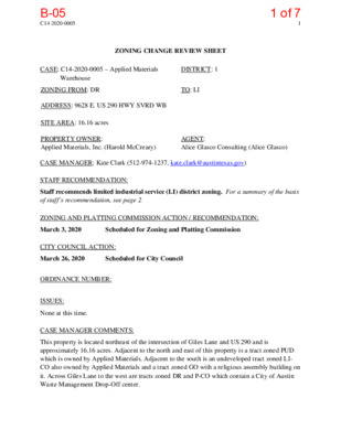
C14-2020-0005 1 ZONING CHANGE REVIEW SHEET CASE: C14-2020-0005 – Applied Materials DISTRICT: 1 Warehouse ZONING FROM: DR ADDRESS: 9628 E. US 290 HWY SVRD WB SITE AREA: 16.16 acres TO: LI PROPERTY OWNER: Applied Materials, Inc. (Harold McCreary) AGENT: Alice Glasco Consulting (Alice Glasco) CASE MANAGER: Kate Clark (512-974-1237, kate.clark@austintexas.gov) STAFF RECOMMENDATION: Staff recommends limited industrial service (LI) district zoning. For a summary of the basis of staff’s recommendation, see page 2. ZONING AND PLATTING COMMISSION ACTION / RECOMMENDATION: March 3, 2020 Scheduled for Zoning and Platting Commission CITY COUNCIL ACTION: March 26, 2020 Scheduled for City Council ORDINANCE NUMBER: ISSUES: None at this time. CASE MANAGER COMMENTS: This property is located northeast of the intersection of Giles Lane and US 290 and is approximately 16.16 acres. Adjacent to the north and east of this property is a tract zoned PUD which is owned by Applied Materials. Adjacent to the south is an undeveloped tract zoned LI- CO also owned by Applied Materials and a tract zoned GO with a religious assembly building on it. Across Giles Lane to the west are tracts zoned DR and P-CO which contain a City of Austin Waste Management Drop-Off center. 1 of 7B-05 C14-2020-0005 2 BASIS OF RECOMMENDATION: 1. Zoning changes should promote compatibility with adjacent and nearby uses. The applicant is requesting to rezone from DR to LI. This tract is adjacent to an existing LI base zoning district and a PUD tract with similar allowed land uses. Rezoning this tract to LI would not be introducing a new zoning district to the area and would be compatible with surrounding land uses. EXISTING ZONING AND LAND USES: Zoning Land Uses Site DR North PUD Vacant Industrial (Applied Materials) South LI-CO and GO Vacant, religious assembly building East PUD Industrial (Applied Materials) West P-CO and DR (across Giles Lane) City of Austin Waste Management Drop-Off Center NEIGHBORHOOD PLANNING AREA: N/A TIA: The TIA determination will be deferred to site plan submittal when land uses and intensities have been finalized. WATERSHED: Decker Creek (suburban) OVERLAYS: None SCHOOLS: Bluebonnet Trail Elementary, Decker Middle and Manor High Schools (Manor ISD) NEIGHBORHOOD ORGANIZATIONS Austin Neighborhoods Council Bike Austin Del Valle Community Coalition Friends of Austin Neighborhoods Harris Branch Residential Property Owners Homeless Neighborhood Association Neighborhood Empowerment Foundation Neighbors United for Progress North Growth Corridor Alliance SELTexas Sierra Club, Austin Regional Group 2 of 7B-05 C14-2020-0005 3 AREA CASE HISTORIES: Number Request Commission City Council C14-2020-0004 DR to LI In progress In progress C14-00-2227 DR to LI Approved LI-CO, with CO limiting trips to 2,000/day. Approved LI-CO as Commission recommended. RELATED CASES: None at this time. EXISTING STREET CHARACTERISTICS: Street ROW Pavement Classification Sidewalks Bike Route Capital Metro (within ¼ mile) Giles Road 84’ 78’ 3 Yes Yes Yes OTHER STAFF COMMENTS: Comprehensive Planning This zoning case is located near the northeast corner of East US 290 and Giles Lane, on a 16.16 acre parcel, which is undeveloped, and is not located near an Activity Corridor or Center or in a neighborhood planning area. Surrounding land uses includes vacant land and an Applied Materials facility (chips, coatings and display manufacturer) to the north; to the south is a religious assembly building and US 290, south of US 290 is vacant land, a nursing home, a truck depot, a tire store and an office use; to the east is vacant land and Applied Materials; and to the west is a City maintained waste management center. The proposed use is an Applied Materials industrial warehouse. Connectivity There are public sidewalks on the frontage road of US 290 and Giles Lane, but no bike lanes or public transit stops. The mobility and connectivity options in the area are below average. Imagine Austin The property is not located by or near an Activity Corridor or Center. The following Imagine Austin policies are applicable to this case: • LUT P4. Protect neighborhood character by directing growth to areas of change that includes designated redevelopment areas, corridors and infill sites. Recognize that 3 of 7B-05 C14-2020-0005 4 different neighborhoods have different characteristics and new and infill development should be sensitive to the predominant character of these communities. • LUT P20. Locate industry, warehousing, logistics, manufacturing, and other freight- intensive uses in proximity to adequate transportation and utility infrastructure. Based on this property: (1) having a large number of other light industrial and/or office/warehouses located within a mile radius of this site; and (2) the Imagine Austin policies above that recognize that different neighborhood have different characteristics, including an area having warehouse and industrial uses; and (3) the property being situated along US 290 and less than a mile from Highway 130, which would provide access to the entire region, this proposed industrial warehouse supports the Imagine Austin Comprehensive Plan. Environmental The site is not located over the Edwards Aquifer Recharge Zone. The site is in the Decker Creek Watershed of the Colorado River Basin, which is classified as a Suburban Watershed by Chapter 25-8 of the City's Land Development Code. Under current watershed regulations, development or redevelopment on this site will be subject to the following impervious cover limits: Development Classification % of Gross Site Area % of Gross Site Area with Transfers Single-Family (minimum lot size 5750 sq. ft.) 50% Other Single-Family or Duplex 55% Multifamily Commercial 60% 80% 60% 60% 70% 90% According to floodplain maps there is no floodplain within or adjacent to the project location. Standard landscaping and tree protection will be required in accordance with LDC 25-2 and 25-8 for all development and/or redevelopment. At this time, site specific information is unavailable regarding vegetation, areas of steep slope, or other environmental features such as bluffs, springs, canyon rimrock, caves, sinkholes, and wetlands. Under current watershed regulations, development or redevelopment requires water quality control with increased capture volume and control of the 2 year storm on site. At this time, no information has been provided as to whether this property has any preexisting approvals that preempt current water quality or Code requirements. 4 of 7B-05 C14-2020-0005 5 Site Plan Site plans will be required for any new development other than single-family or duplex residential. Any development which occurs in an SF-6 or less restrictive zoning district which is located 540 feet or less from property in an SF-5 or more restrictive zoning district will be subject to compatibility development regulations. Any new development is subject to Subchapter E. Design Standards and Mixed Use. Additional comments will be made when the site plan is submitted. Transportation The TIA determination will be deferred to site plan submittal when land uses and intensities have been finalized. The Austin Strategic Mobility Plan (ASMP) adopted 04/11/2019, calls for 94 feet of right-of-way for Giles Road. It is recommended that 47 feet of right-of-way from the existing centerline should be dedicated for Giles Road according to the Transportation Plan at the time of site plan. [LDC 25-6-51 and 25-6-55]. Austin Water Utility This site is currently served by an On-Site Sewage Facility. No City wastewater service is available. If wastewater service is desired, a service extension request (SER) will be required to provide service to this lot. City Council approval of the SER is required due to the property’s location within the Drinking Water Protection Zone and outside the full purpose corporate limits (LDC 25-9-35). For more information pertaining to the Service Extension Request process and submittal requirements contact Alberto Ramirez with Austin Water, Utility Development Services at 625 E. 10th St., 7th floor. Ph: 512-972-0211. The landowner intends to serve the site with City of Austin water and unknown wastewater utilities. The landowner, at own expense, will be responsible for providing any water and wastewater utility improvements, offsite main extensions, utility relocations and or abandonments required by the land use. The water and wastewater utility plan must be reviewed and approved by Austin Water for compliance with City criteria and suitability for operation and maintenance. Depending on the development plans submitted, water and or wastewater service extension requests may be required. All water and wastewater construction must be inspected by the City of Austin. The landowner must pay the City inspection fee with the utility construction. The landowner must pay the tap and impact fee once the landowner makes an application for a City of Austin water and wastewater utility tap permit. INDEX OF EXHIBITS TO FOLLOW Exhibit A: Zoning Map Exhibit B: Aerial Map 5 of 7B-05 DR Q28 P-CO N S L E GIL DR C14-2020-0005 PUD 0 M 9 A P S 2 B R E U W E U S 2 9 0 E B R A M P P28 I-RR ± 1'' = 400' GO DR DR B E O T 0 9 2 B W Y N N H O J T A 0 9 2 I N R T S R R O M GR CS CS T C R I O V R E S E R P27 E U S 2 9 0 H W Y S V R D E B E U S 29 0 H W Y S V R D W B DR B W O T 0 9 2 B E Y N N H O J T A 0 9 2 N R T S R R O M I D RIS R Y N N H O R J O M LI-CO E U S 2 9 0 H W Y S V R D W B E U S 2 9 0 H W Y W B E U S 2 9 0 H W Y E B E U S 2 9 0 H W Y S V R D E B Q27 N D L R O F F O R C SUBJECT TRACT ZONING BOUNDARY Creek Buffers Applied Materials Warehouse ZONING CASE#: LOCATION: SUBJECT AREA: GRID: MANAGER: C14-2020-0005 9628 E. US 290 Hwy SR WB 16.1568 Acres Q28 Heather Chaffin This map has been produced by the Communications Technology Management Dept. on behalf of the Planning Development Review Dept. for the sole purpose of geographic reference. No warranty is made by the City of Austin regarding specific accuracy or completeness. 6 of 7B-05 DR Q28 P-CO N S L E GIL DR C14-2020-0005 PUD 0 M 9 A P S 2 B R E U W E U S 2 9 0 E B R A M P P28 I-RR ± 1'' = 400' GO DR DR B E O T 0 9 2 B W Y N N H O J T A 0 9 2 I N R T S R R O M GR CS CS T C R I O V R E S E R P27 E U S 2 9 0 H W Y S V R D E B E U S 29 0 H W Y S V R D W B DR B W O T 0 9 2 B E Y N N H O J T A 0 9 2 N R T S R R O M I D RIS R Y N N H O R J O M LI-CO E U S 2 9 0 H W Y S V R D W B E U S 2 9 0 H W Y W B E U S 2 9 0 H W Y E B E U S 2 9 0 H W Y S V R D E B Q27 N D L R O F F O R C Copyright nearmap 2015 SUBJECT TRACT ZONING BOUNDARY Creek Buffers Applied Materials Warehouse ZONING CASE#: LOCATION: SUBJECT AREA: GRID: MANAGER: C14-2020-0005 9628 E. US 290 Hwy SR WB 16.1568 Acres Q28 Heather Chaffin This map has been produced by the Communications Technology Management Dept. on behalf of the Planning Development Review Dept. for the sole purpose of geographic reference. No warranty is made by the City of Austin regarding specific accuracy or completeness. 7 of 7B-05