Item B-07 (SP-2018-0565D - Ventura at Parmer Lane).pdf — original pdf
Backup
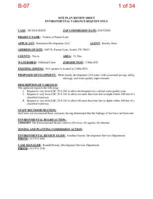
SITE PLAN REVIEW SHEET ENVIRONMENTAL VARIANCE REQUEST ONLY CASE: SP-2018-0565D ZAP COMMISSION DATE: 01/07/2020 PROJECT NAME: Ventura at Parmer Lane APPLICANT: Dominium Development, LLC. AGENT: Kimley-Horn ADDRESS OF SITE: 8407 E. Parmer Lane, Austin, TX 78653 COUNTY: Travis AREA: 31.29ac. WATERSHED: Gilleland Creek JURISDICTION: 2-Mile ETJ EXISTING ZONING: N/A (project is located in 2-Mile ETJ) PROPOSED DEVELOPMENT: Multi-family development (216 units) with associated paving, utility, drainage, and water quality improvements DESCRIPTION OF VARIANCE: The applicant requests the following: 1. Request to vary from LDC 25-8-261 to allow development in a critical water quality zone. 2. Request to vary from LDC 25-8-341 to allow cut more than four feet in depth within 100 feet of a classified waterway. 3. Request to vary from LDC 25-8-342 to allow fill more than four feet in depth within 100 feet of a classified waterway. STAFF RECOMMENDATION: Staff does not recommend these variances, having determined that the findings of fact have not been met. ENVIRONMENTAL BOARD ACTION: 12/04/2019: The Environmental Board voted in (10) favor, (0) against, (0) absentia ZONING AND PLATTING COMMISSION ACTION: ENVIRONMENTAL REVIEW STAFF: Jonathan Garner, Development Services Department PHONE: 512-974-1665 CASE MANAGER: Randall Rouda, Development Services Department PHONE: 512-974-3338 1 of 34B-07 1 ENVIRONMENTAL COMMISSION MOTION 20191204 008a Date: December 4, 2019 Subject: Ventura at Parmer Lane, SP-2018-0565D Motion by: Andrew Creel Seconded by: Wendy Gordon RATIONALE: WHEREAS, the Environmental Commission recognizes that the provision of affordable housing in the City of Austin is vital to ensure a resilient and equitable future for our City; and WHEREAS, the Environmental Commission recognizes that the applicant has worked to design improvements to the site that would have overall environmental benefits, including reduction in impervious cover and the protection of heritage trees. THEREFORE, the Environmental Commission recommends approval of the requested variances: to vary from LDC 25-8-261 to allow development in a critical water quality zone, to vary from LDC 25-8-341 to allow cut more than four feet in depth within 100 feet of a classified waterway, and to vary from LDC 25-8-341 to allow fill more than four feet in depth within 100 feet of a classified waterway with the following Environmental Commission conditions: 1. A restricted covenant to limit total development to 30% impervious cover 2. Commitment from the applicant to protect or mitigate at 300% any heritage trees removed on site 3. Restoration and preparation of a management plan for riparian zones approved by the Watershed Protection Department. 4. The applicant will continue to work in good faith with the Watershed Protection Department to ensure site scale environmental superiority. 5. Mitigate wetland impacts at a 1:1 ratio 6. Utilization of native and adapted plantings site wide, including planting plans with Blackland Prairie species 7. Compliance with dark skies design standards 8. Both CWQZ crossings will incorporate a span bridge that is not less than 20’ from the creek centerline in lieu of culvert crossings, (with potential additional culverts beyond the 40 ft span as needed) and incorporate structural controls to further reduce cut and fill required in the critical water quality zone. VOTE 10-0 For: Bedford, Smith, Creel, Thompson, Guerrero, Coyne, Nill, Neely, Maceo, and Gordon 2 of 34B-07 2 Against: None Abstain: None Recuse: Ramberg Absent: None Approved By: Linda Guerrero, Environmental Commission Chair 3 of 34B-07 Staff Findings of Fact and Exhibits 4 of 34B-07 Development Services Department Staff Recommendations Concerning Required Findings Project Name: Ventura at Parmer Lane SP-2018-0565D Ordinance Standard: Watershed Protection Ordinance Variance Request: LDC 25-8-261 – to allow development in a critical water quality zone Include an explanation with each applicable finding of fact. A.Land Use Commission variance determinations from Chapter 25-8-41 of the City Code:1.The requirement will deprive the applicant of a privilege available to owners ofsimilarly situated property with approximately contemporaneous developmentsubject to similar code requirements.No The property contains uplands that are completely developable without the need for a variance from the Land Development Code. The majority of the parcel can be developed without the additional crossing of the critical water quality zone. Although the private drive crossing the critical water quality zone would allow for more development on the property, the Land Development Code does not provide an allowance for non-complying development of a parcel to maximize the amount of development that can occur on the property. Additionally, an alternative access route from the neighboring property could be available through a joint use access easement. 2.The variance:a)Is not necessitated by the scale, layout, construction method, or otherdesign decision made by the applicant, unless the design decisionprovides greater overall environmental protection than is achievablewithout the variance;No The proposed private drive crossing the critical water quality zone is a design decision made by the applicant. The majority of the property can be developed without the requested crossing of the critical water quality zone. An alternative means of access from a neighboring property could be available. The design decision does not provide greater overall environmental protection. 5 of 34B-07 b)Is the minimum deviation from the code requirement necessary toallow a reasonable use of the property;No Access into the property and development of a portion of the uplands is allowed by code, and the proposed development on this portion of the property complies with all code requirements. The secondary proposed private drive crossing the critical water quality zone requires additional variances to the Land Development Code for its construction. c)Does not create a significant probability of harmful environmentalconsequences.No The proposed private drive crossing the critical water quality zone requires additional variances to the Land Development Code for its construction, as well as a significant portion of modification to the 100-year floodplain and restoration and mitigation of impacted wetland critical environmental features. 3.Development with the variance will result in water quality that is at least equalto the water quality achievable without the variance.Yes The proposed private drive crossing the critical water quality zone willhave inlets and storm pipes to collect all stormwater runoff to beconveyed to the water quality and detention facilities on site.B.The Land Use Commission may grant a variance from a requirement of Section 25-8-422 (Water Supply Suburban Water Quality Transition Zone), Section 25-8-452 (WaterSupply Rural Water Quality Transition Zone), Section 25-8-482 (Barton Springs ZoneWater Quality Transition Zone), Section 25-8-368 (Restrictions on DevelopmentImpacting Lake Austin, Lady Bird Lake, and Lake Walter E. Long), or Article 7,Division 1 (Critical Water Quality Zone Restrictions), after determining that::1.The criteria for granting a variance in Subsection (A) are met;No Alternative access routes may be available through a joint use access easement with the neighboring property. Additionally, the construction method proposed requires additional variances to the Land Development Code requirements. 2.The requirement for which a variance is requested prevents a reasonable,economic use of the entire property;No The property contains uplands that are completely developable without the need for a variance from the Land Development Code. Although the private drive crossing the critical water quality zone would allow for more development on the property, the Land Development Code does not provide an allowance for development of a parcel of land to occur without meeting all code requirements, including access. 6 of 34B-07 3.The variance is the minimum deviation from the code requirement necessary toallow a reasonable, economic use of the entire property.No Access into the property and development of a portion of the uplands isallowed by code, and the proposed development on this portion of theproperty complies with all code requirements. The secondary proposedprivate drive crossing the critical water quality zone requires additionalvariances to the Land Development Code for its construction.Staff Determination: Staff determines that the findings of fact have not been met. Therefore, staff does not recommend approval of the variance request. _____________________________ Jonathan Garner Date: 11-13-2019 Date: 11-13-2019 Environmental Reviewer (DSD) Environmental Review Manager (DSD)Environmental Officer (WPD) ____________________________Mike McDougal ____________________________Chris HerringtonDate: 11/25/20197 of 34B-07 Development Services Department Staff Recommendations Concerning Required Findings Project Name: Ventura at Parmer Lane SP-2018-0565D Ordinance Standard: Watershed Protection Ordinance Variance Request: LDC 25-8-341 to allow cut of more than four feet within 100 feet of a classified waterway Include an explanation with each applicable finding of fact. A.Land Use Commission variance determinations from Chapter 25-8-41 of the City Code:1.The requirement will deprive the applicant of a privilege available to owners ofsimilarly situated property with approximately contemporaneous developmentsubject to similar code requirements.No The portion of cut exceeding four feet and within 100 feet of aclassified waterway is for the construction of a private drive crossing a criticalwater quality zone that is also not allowed by the Land Development Code.Were the depth of cut within 100 feet of a classified waterway within the fourfoot restriction of LDC 25-8-341, all other areas of cut exceeding four feet indepth but not more than eight feet on the property would be allowable throughan administrative environmental variance.2.The variance:a)Is not necessitated by the scale, layout, construction method, or otherdesign decision made by the applicant, unless the design decisionprovides greater overall environmental protection than is achievablewithout the variance;NoThere are alternative methods of constructing a private drivespanning a classified waterway that would not require cut inexcess of four feet.b)Is the minimum deviation from the code requirement necessary toallow a reasonable use of the property;NoAlternate methods of construction exist that would not require an amount of cut in excess of that allowed by the Land Development Code. 8 of 34B-07 c)Does not create a significant probability of harmful environmentalconsequences.NoThe excess cut will result in modifications to the floodplain, including loss of native vegetation and soils that aid in riparian health and floodplain function. 3.Development with the variance will result in water quality that is at least equalto the water quality achievable without the variance.NoAlternate methods of construction exist that would not require an amount of cut in excess of that allowed by the Land Development Code. The method chosen will result in an excess loss of native soils and riparian vegetation, as well as create potential for creek channel incising, degradation of downstream water quality, loss of aquatic habitat, and replace the void with concrete structures. B.The Land Use Commission may grant a variance from a requirement of Section 25-8-422 (Water Supply Suburban Water Quality Transition Zone), Section 25-8-452 (WaterSupply Rural Water Quality Transition Zone), Section 25-8-482 (Barton Springs ZoneWater Quality Transition Zone), Section 25-8-368 (Restrictions on DevelopmentImpacting Lake Austin, Lady Bird Lake, and Lake Walter E. Long), or Article 7,Division 1 (Critical Water Quality Zone Restrictions), after determining that::1.The criteria for granting a variance in Subsection (A) are met;N/A2.The requirement for which a variance is requested prevents a reasonable,economic use of the entire property;N/A3.The variance is the minimum deviation from the code requirement necessary toallow a reasonable, economic use of the entire property.N/AStaff Determination: Staff determines that the findings of fact have not been met. Therefore, staff does not recommend approval of the variance request. Environmental Reviewer (DSD) _____________________________ Jonathan Garner Date: 11-13-2019 Environmental Review Manager (DSD) _____________________________ Mike McDougal Date: 11-13-2019 Environmental Officer (WPD) _____________________________ Chris HerringtonDate 11/25/2019 9 of 34B-07 Development Services Department Staff Recommendations Concerning Required Findings Project Name: Ventura at Parmer Lane SP-2018-0565D Ordinance Standard: Watershed Protection Ordinance Variance Request: LDC 25-8-342 to allow fill of more than four feet within 100 feet of a classified waterway Include an explanation with each applicable finding of fact. A.Land Use Commission variance determinations from Chapter 25-8-41 of the City Code:1.The requirement will deprive the applicant of a privilege available to owners ofsimilarly situated property with approximately contemporaneous developmentsubject to similar code requirements.No The portion of fill exceeding four feet and within 100 feet of aclassified waterway is for the construction of two private drives crossing acritical water quality zone. One of these drives is allowed by the LandDevelopment Code, for it is necessary to facilitate the development orredevelopment of a designated corridor or center as recommended in theImagine Austin Comprehensive Plan [LDC 25-8-262(D)(1)]. The other privatedrive crossing the critical water quality zone is not allowed by the LandDevelopment Code and is seeking an additional variance. Were the depth of fillwithin 100 feet of a classified waterway within the four foot restriction of LDC25-8-342, all other areas of fill exceeding four feet in depth but not more thaneight feet on the property would be allowable through an administrativeenvironmental variance.2.The variance:a)Is not necessitated by the scale, layout, construction method, or otherdesign decision made by the applicant, unless the design decisionprovides greater overall environmental protection than is achievablewithout the variance;NoThere are alternative methods of constructing a private drivespanning a classified waterway that would not require fill inexcess of four feet.b)Is the minimum deviation from the code requirement necessary toallow a reasonable use of the property;10 of 34B-07 No Alternate methods of construction exist that would not require an amount of fill in excess of that allowed by the Land Development Code. c)Does not create a significant probability of harmful environmentalconsequences.NoThe excess fill will result in modifications to the floodplain, including loss of native vegetation and soils that aid in riparian health and floodplain function. 3.Development with the variance will result in water quality that is at least equalto the water quality achievable without the variance.NoAlternate methods of construction exist that would not require an amount of fill in excess of that allowed by the Land Development Code. The method chosen will result in additional soil within a floodplain area and on a slope that has the potential to be highly erosive and cause sediment deposition in the creek, will contain backfill areas of construction with rock riprap that prevents infiltration of water and the growth of riparian vegetation, and causes additional construction activities in the floodplain to mitigate for the area of floodplain replaced by excess fill material. B.The Land Use Commission may grant a variance from a requirement of Section 25-8-422 (Water Supply Suburban Water Quality Transition Zone), Section 25-8-452 (WaterSupply Rural Water Quality Transition Zone), Section 25-8-482 (Barton Springs ZoneWater Quality Transition Zone), Section 25-8-368 (Restrictions on DevelopmentImpacting Lake Austin, Lady Bird Lake, and Lake Walter E. Long), or Article 7,Division 1 (Critical Water Quality Zone Restrictions), after determining that:1.The criteria for granting a variance in Subsection (A) are met;N/A2.The requirement for which a variance is requested prevents a reasonable,economic use of the entire property;N/A3.The variance is the minimum deviation from the code requirement necessary toallow a reasonable, economic use of the entire property.N/AStaff Determination: Staff determines that the findings of fact have not been met. Therefore, staff does not recommend approval of the variance request. Environmental Reviewer _____________________________ Date: 11-13-2019 (DSD) Jonathan Garner 11 of 34B-07 Environmental Review Manager (DSD) _____________________________ Mike McDougal Date: 11-13-2019 Environmental Officer (WPD) ____________________________Chris HerringtonDate 11/25/2019 12 of 34B-07 Applicant Form and Findings of Fact 13 of 34B-07 kimley-horn.com 10814 Jollyville Road, Building 4, Suite 300, Austin, TX 78759 512 418 1771 October 22, 2019 City of Austin 505 Barton Springs Road, 4th Floor Austin, TX 78704 RE: Environmental Commission Variance Request Ventura at Parmer Lane (SP-2018-0565D) To Whom It May Concern: On behalf of our client, Dominium, Inc., Kimley-Horn is requesting a waiver from LDC 25-8-261 to cross the Critical Water Quality Zone. Per the attached Environmental Commission Variance Application Form Findings of Fact, this waiver is required to allow for the development of a tract of land bounded by East Parmer Lane to the North, and SH 130 to the South and West. This crossing will provide access to 2.5 otherwise developable acres of land and establish approximately 72 multifamily units within the Desired Development Zone. The entire 216 unit apartment complex is located along an Imagine Austin Corridor and near a Town Center as denoted in the Imagine Austin Comprehensive Plan. This variance requests one crossing of the CWQZ. Your favorable consideration of this request is appreciated. Should you require additional information, please contact me at (512) 350-5703 or rob.smith@kimley-horn.com. Sincerely, Robert J. Smith, P.E. Project Manager Kimley-Horn and Associates, Inc. 14 of 34B-07 October 22, 2019 City of Austin | Environmental Commission Variance Application Guide 1 ENVIRONMENTAL COMMISSION VARIANCE APPLICATION FORM PROJECT DESCRIPTION Applicant Contact Information Name of Applicant Robert J. Smith, P.E. Street Address 10814 Jollyville Road, Building 4, Suite 300 City State ZIP Code Austin, TX 78759 Work Phone 512-418-4517E-Mail AddressRob.smith@kimley-horn.com Variance Case Information Case Name Ventura at Parmer Lane Case Number SP-2018-0565D Address or Location 8407 E Parmer Lane, Austin, TX 78653 Environmental Reviewer Name Jonathan Garner Environmental Resource Management Reviewer Name Andrew Clamann Applicable Ordinance 25-8-261Watershed Name Gilleland Creek Watershed Classification ☐Urban☐Suburban ☐Water Supply Suburban☐Water Supply Rural☐Barton Springs Zone15 of 34B-07 October 22, 2019 City of Austin | Environmental Commission Variance Application Guide 2 Edwards Aquifer Recharge Zone ☐Barton Springs Segment☐Northern Edwards Segment☐Not in Edwards Aquifer ZonesEdwards Aquifer Contributing Zone ☐Yes☐NoDistance to Nearest Classified Waterway On-Site Water and Waste Water service to be provided by AWU Request The variance request is as follows: 25-8-261 CWQZ DevelopmentImpervious cover square footage: acreage: percentage: Existing 169,788_ 3.89____ 12.47%__ Proposed 333,501__ 7.66_____ 24.49%___ Provide general description of the property (slope range, elevation range, summary of vegetation / trees, summary of the geology, CWQZ, WQTZ, CEFs, floodplain, heritage trees, any other notable or outstanding characteristics of the property) Commercial development and single-family residences currently exist on the property, and there is a substantial amount of gravel and impervious cover within the current CWQZ from previous development that will be removed and revegetated. 97.5% of the property falls within the 0% to 15% slope category. The remainder property has slopes exceeding 15% slope. The property ranges in elevation from 565 to 524 MSL. On-site soils are Type D Expansive Clays and is identified as Blackland Prairie. Multiple wetland CEF’s, and Critical Water Quality Zones exist within the site. Fully developed 100-year and 500-year floodplains exist within the site. 16 of 34B-07 October 22, 2019 City of Austin | Environmental Commission Variance Application Guide 3 FINDINGS OF FACT As required in LDC Section 25-8-41, in order to grant a variance the Land Use Commission must make the following findings of fact: Include an explanation with each applicable finding of fact. Project: Ventura at Parmer Lane Ordinance: 25-8-261 CWQZ Development A. Land Use Commission variance determinations from Chapter 25-8-41 of the City Code: 1.The requirement will deprive the applicant of a privilege available to owners of similarlysituated property with approximately contemporaneous development subject to similarcode requirements.Yes Access is limited to the otherwise developable land located within the 0% to 15% slope category by the CWQZ. In order to comply with the International Fire Code Appendix D, as adopted by Travis County Emergency Service District #12, regarding two points of access to the site and TxDOT driveway spacing criteria, the proposed grades will need to exceed the cut and fill allowed by Chapter 30. 2.The variance:a)Is not necessitated by the scale, layout, construction method, or other designdecision made by the applicant, unless the design decision provides greateroverall environmental protection than is achievable without the variance;Yes Ventura at Parmer Lane is a multifamily development generally designed to follow the existing topography to preserve the natural character of the property. In addition, multiple water quality and detention basins have been placed in natural low areas to preserve the existing drainage patterns. Clearly indicate in what way the proposed project does not comply with current Code (include maps and exhibits) Due to TXDOT driveway spacing and Travis County ESD #12 fire access requirements, a private drive aisle crossing the CWQZ is necessary to reach otherwise developable land on the property. 17 of 34B-07 October 22, 2019 City of Austin | Environmental Commission Variance Application Guide 4 b)Is the minimum deviation from the code requirement necessary to allow areasonable use of the property;Yes Ventura at Parmer Lane has been designed to minimally deviate fromthe code to allow for two access points meeting TCESD#12 requirements. Thepercentage of the property exceeding the allowable cut/fill for this property is10.6%.Based on input from City staff, the final grades were reduced to below 8ftcut/fill (to minimally deviate from code) by increasing the number of stormsewer culverts under the roadways crossing the CWQZ and while maintainingDrainage Criteria Manual requirements for conveyance of the 100-year storm.c)Does not create a significant probability of harmful environmentalconsequences.Yes The proposed roadways and associated drainage system have beendesigned to protect the natural character and function of the CriticalEnvironmental Features and Critical Water Quality Zones by ensuring theyreceive the required surface water runoff quantity and quality needed topromote wetland and floodplain health.The proposed design preserves the natural drainage patterns by detaining andtreating stormwater in multiple basins throughout the property.In addition, the proposed design removes the +/-150,000 sf of existingimpervious cover located in the CWQZ and restoration of the CWQZ with 609Sseed mix and native plantings.3.Development with the variance will result in water quality that is at least equal to thewater quality achievable without the variance.Yes The proposed design adheres to all water quality requirements outlined within the Environmental Criteria Manual and as such, will result in water quality that is at least equal to water quality achievable without the variance. Biofiltration ponds have been sized to treat all proposed impervious cover on the site. B.Additional Land Use Commission variance determinations for a requirement of Section 25-8-422(Water Quality Transition Zone), Section 25-8-452 (Water Quality Transition Zone), Article 7,Division 1 (Critical Water Quality Zone Restrictions), or Section 25-8-368 (Restrictions onDevelopment Impacting Lake Austin, Lady Bird Lake, and Lake Walter E. Long):1.The criteria for granting a variance in Subsection (A) are met;Yes This request meets the criteria set forth in Section (A). 18 of 34B-07 October 22, 2019 City of Austin | Environmental Commission Variance Application Guide 5 2.The requirement for which a variance is requested prevents a reasonable, economic useof the entire property;Yes The site will be developed with approximately 25% impervious cover, comparedto the 60% allowable in suburban watersheds. In addition to the fire coderequirements mentioned above, the site lies along an Imagine Austin Corridor.3.The variance is the minimum deviation from the code requirement necessary to allow areasonable, economic use of the entire property.Yes As mentioned above in A.2.b, the CWQZ crossing is designed to minimallydeviate from code in order to comply with Travis County ESD #12 fire coderequirements. The design of the drive aisle has been chosen to avoid impacts toenvironmental areas in order to reach the otherwise developable land acrossthe CWQZ.**Variance approval requires all above affirmative findings. 19 of 34B-07 kimley-horn.com 10814 Jollyville Road, Building 4, Suite 300, Austin, TX 78759 512 418 1771 October 22, 2019 City of Austin 505 Barton Springs Road, 4th Floor Austin, TX 78704 RE: Environmental Commission Cut/Fill Variance Request Ventura at Parmer Lane (SP-2018-0565D) To Whom It May Concern: On behalf of our client, Dominium, Inc., Kimley-Horn is requesting a Cut/Fill waiver from LDC 25-8- 341 & 25-8-342. The request is to cut more than 4-feet and fill more than 4-feet.Per the attached Environmental Commission Variance Application Form Findings of Fact, this waiver is required to allow for the development of a tract of land bounded by East Parmer Lane to the North, and SH 130 to the South and West. This development will provide approximately 216 multifamily units within the Desired Development Zone and is located along an Imagine Austin Corridor and near a Town Center as denoted in the Imagine Austin Comprehensive Plan. The maximum cut proposed with this variance request is 6.1 feet and the maximum fill proposed with this variance request is 7.9 feet. Your favorable consideration of this request is appreciated. Should you require additional information, please contact me at (512) 350-5703 or rob.smith@kimley-horn.com. Sincerely, Robert J. Smith, P.E. Project Manager Kimley-Horn and Associates, Inc. 20 of 34B-07 October 23, 2019 City of Austin | Environmental Commission Variance Application Guide 1 ENVIRONMENTAL COMMISSION VARIANCE APPLICATION FORM PROJECT DESCRIPTION Applicant Contact Information Name of Applicant Robert J. Smith, P.E. Street Address 10814 Jollyville Road, Building 4, Suite 300 City State ZIP Code Austin, TX 78759 Work Phone 512-418-4517 E-Mail Address Rob.smith@kimley-horn.com Variance Case Information Case Name Ventura at Parmer Lane Case Number SP-2018-0565D Address or Location 8407 E Parmer Lane, Austin, TX 78653 Environmental Reviewer Name Jonathan Garner Environmental Resource Management Reviewer Name Andrew Clamann Applicable Ordinance 25-8-341 Watershed Name Gilleland Creek Watershed Classification ☐Urban ☐ Suburban ☐Water Supply Suburban ☐Water Supply Rural ☐ Barton Springs Zone 21 of 34B-07 October 23, 2019 City of Austin | Environmental Commission Variance Application Guide 2 Edwards Aquifer Recharge Zone ☐Barton Springs Segment☐Northern Edwards Segment☐Not in Edwards Aquifer ZonesEdwards Aquifer Contributing Zone ☐Yes☐NoDistance to Nearest Classified Waterway On-Site Water and Waste Water service to be provided by AWU Request The variance request is as follows: 25-8-341 Cut Requirements Impervious cover square footage: acreage: percentage: Existing 169,788_ 3.89____ 12.47%__ Proposed 333,501__ 7.66_____ 24.49%___ Provide general description of the property (slope range, elevation range, summary of vegetation / trees, summary of the geology, CWQZ, WQTZ, CEFs, floodplain, heritage trees, any other notable or outstanding characteristics of the property) Commercial development and single-family residences currently exist on the property, and there is a substantial amount of gravel and impervious cover within the current CWQZ from previous development that will be removed and revegetated. 97.5% of the property falls within the 0% to 15% slope category. The remainder property has slopes exceeding 15% slope. The property ranges in elevation from 565 to 524 MSL. On-site soils are Type D Expansive Clays and is identified as Blackland Prairie. Multiple wetland CEF’s, and Critical Water Quality Zones exist within the site. Fully developed 100-year and 500-year floodplains exist within the site. 22 of 34B-07 October 23, 2019 City of Austin | Environmental Commission Variance Application Guide 3 FINDINGS OF FACT As required in LDC Section 25-8-41, in order to grant a variance the Land Use Commission must make the following findings of fact: Include an explanation with each applicable finding of fact. Project: Ventura at Parmer Lane Ordinance: 25-8-341 Cut Requirements A. Land Use Commission variance determinations from Chapter 25-8-41 of the City Code: 1.The requirement will deprive the applicant of a privilege available to owners of similarlysituated property with approximately contemporaneous development subject to similarcode requirements.Yes Access is limited to the otherwise developable land located within the 0% to 15% slope category by the CWQZ. In order to comply with the International Fire Code Appendix D, as adopted by Travis County Emergency Service District #12, regarding two points of access to the site and TxDOT driveway spacing criteria, the proposed grades will need to exceed the cut and fill allowed by Chapter 25. 2.The variance:a)Is not necessitated by the scale, layout, construction method, or other designdecision made by the applicant, unless the design decision provides greateroverall environmental protection than is achievable without the variance;Yes Ventura at Parmer Lane is a multifamily development generally designed to follow the existing topography to preserve the natural character of the property. In addition, multiple water quality and detention basins have been placed in natural low areas to preserve the existing drainage patterns. Clearly indicate in what way the proposed project does not comply with current Code (include maps and exhibits) Per the attached cut/fill exhibit, there are areas the require cuts greater than 4’. 23 of 34B-07 October 23, 2019 City of Austin | Environmental Commission Variance Application Guide 4 b)Is the minimum deviation from the code requirement necessary to allow areasonable use of the property;Yes Ventura at Parmer Lane has been designed to minimally deviate fromthe code to allow for two access points meeting TCESD#12 requirements. Thepercentage of the property exceeding the allowable cut/fill for this property is10.6%.Based on input from City staff, the final grades were reduced to below 8ftcut/fill (to minimally deviate from code) by increasing the number of stormsewer culverts under the roadways crossing the CWQZ and while maintainingDrainage Criteria Manual requirements for conveyance of the 100-year storm.c)Does not create a significant probability of harmful environmentalconsequences.Yes The proposed roadways and associated drainage system have beendesigned to protect the natural character and function of the CriticalEnvironmental Features and Critical Water Quality Zones by ensuring theyreceive the required surface water runoff quantity and quality needed topromote wetland and floodplain health.The proposed design preserves the natural drainage patterns by detaining andtreating stormwater in multiple basins throughout the property.In addition, the proposed design removes the +/-150,000 sf of existingimpervious cover located in the CWQZ and restoration of the CWQZ with 609Sseed mix and native plantings.3.Development with the variance will result in water quality that is at least equal to thewater quality achievable without the variance.Yes The proposed design adheres to all water quality requirements outlined within the Environmental Criteria Manual and as such, will result in water quality that is at least equal to water quality achievable without the variance. Biofiltration ponds have been sized to treat all proposed impervious cover on the site. B.Additional Land Use Commission variance determinations for a requirement of Section 25-8-422(Water Quality Transition Zone), Section 25-8-452 (Water Quality Transition Zone), Article 7,Division 1 (Critical Water Quality Zone Restrictions), or Section 25-8-368 (Restrictions onDevelopment Impacting Lake Austin, Lady Bird Lake, and Lake Walter E. Long):1.The criteria for granting a variance in Subsection (A) are met;N/A to this variance request.24 of 34B-07 October 23, 2019 City of Austin | Environmental Commission Variance Application Guide 5 2.The requirement for which a variance is requested prevents a reasonable, economic useof the entire property;N/A to this variance request. 3.The variance is the minimum deviation from the code requirement necessary to allow areasonable, economic use of the entire property.N/A to this variance request. **Variance approval requires all above affirmative findings. 25 of 34B-07 October 23, 2019 City of Austin | Environmental Commission Variance Application Guide 1 ENVIRONMENTAL COMMISSION VARIANCE APPLICATION FORM PROJECT DESCRIPTION Applicant Contact Information Name of Applicant Robert J. Smith, P.E. Street Address 10814 Jollyville Road, Building 4, Suite 300 City State ZIP Code Austin, TX 78759 Work Phone 512-418-4517E-Mail AddressRob.smith@kimley-horn.com Variance Case Information Case Name Ventura at Parmer Lane Case Number SP-2018-0565D Address or Location 8407 E Parmer Lane, Austin, TX 78653 Environmental Reviewer Name Jonathan Garner Environmental Resource Management Reviewer Name Andrew Clamann Applicable Ordinance 25-8-342Watershed Name Gilleland Creek Watershed Classification ☐Urban☐Suburban ☐Water Supply Suburban☐Water Supply Rural☐Barton Springs Zone26 of 34B-07 October 23, 2019 City of Austin | Environmental Commission Variance Application Guide 2 Edwards Aquifer Recharge Zone ☐Barton Springs Segment☐Northern Edwards Segment☐Not in Edwards Aquifer ZonesEdwards Aquifer Contributing Zone ☐Yes☐NoDistance to Nearest Classified Waterway On-Site Water and Waste Water service to be provided by AWU Request The variance request is as follows: 25-8-342 Fill Requirements Impervious cover square footage: acreage: percentage: Existing 169,788_ 3.89____ 12.47%__ Proposed 333,501__ 7.66_____ 24.49%___ Provide general description of the property (slope range, elevation range, summary of vegetation / trees, summary of the geology, CWQZ, WQTZ, CEFs, floodplain, heritage trees, any other notable or outstanding characteristics of the property) Commercial development and single-family residences currently exist on the property, and there is a substantial amount of gravel and impervious cover within the current CWQZ from previous development that will be removed and revegetated. 97.5% of the property falls within the 0% to 15% slope category. The remainder property has slopes exceeding 15% slope. The property ranges in elevation from 565 to 524 MSL. On-site soils are Type D Expansive Clays and is identified as Blackland Prairie. Multiple wetland CEF’s, and Critical Water Quality Zones exist within the site. Fully developed 100-year and 500-year floodplains exist within the site. 27 of 34B-07 October 23, 2019 City of Austin | Environmental Commission Variance Application Guide 3 FINDINGS OF FACT As required in LDC Section 25-8-41, in order to grant a variance the Land Use Commission mustmake the following findings of fact: Include an explanation with each applicable finding of fact. Project: Ventura at Parmer Lane Ordinance: 25-8-342 Fill Requirements A. Land Use Commission variance determinations from Chapter 25-8-41 of the City Code:1.The requirement will deprive the applicant of a privilege available to owners of similarlysituated property with approximately contemporaneous development subject to similarcode requirements.Yes Access is limited to the otherwise developable land located within the 0% to 15% slope category by the CWQZ. In order to comply with the International Fire Code Appendix D, as adopted by Travis County Emergency Service District #12, regarding two points of access to the site and TxDOT driveway spacing criteria, the proposed grades will need to exceed the cut and fill allowed by Chapter 25.2.The variance:a)Is not necessitated by the scale, layout, construction method, or other designdecision made by the applicant, unless the design decision provides greateroverall environmental protection than is achievable without the variance;Yes Ventura at Parmer Lane is a multifamily development generally designed to follow the existing topography to preserve the natural character of the property. In addition, multiple water quality and detention basins have been placed in natural low areas to preserve the existing drainage patterns. Clearly indicate in what way the proposed project does not comply with current Code (include maps and exhibits) Per the attached cut/fill exhibit, there are areas the require fills greater than 4’. 28 of 34B-07 October 23, 2019 City of Austin | Environmental Commission Variance Application Guide 4 b)Is the minimum deviation from the code requirement necessary to allow areasonable use of the property;Yes Ventura at Parmer Lane has been designed to minimally deviate from the code to allow for two access points meeting TCESD#12 requirements. The percentage of the property exceeding the allowable cut/fill for this property is 10.6%. Based on input from City staff, the final grades were reduced to below 8ft cut/fill (to minimally deviate from code) by increasing the number of storm sewer culverts under the roadways crossing the CWQZ and while maintaining Drainage Criteria Manual requirements for conveyance of the 100-year storm. c)Does not create a significant probability of harmful environmentalconsequences.Yes The proposed roadways and associated drainage system have been designed to protect the natural character and function of the Critical Environmental Features and Critical Water Quality Zones by ensuring they receive the required surface water runoff quantity and quality needed to promote wetland and floodplain health. The proposed design preserves the natural drainage patterns by detaining and treating stormwater in multiple basins throughout the property. In addition, the proposed design removes the +/-150,000 sf of existing impervious cover located in the CWQZ and restoration of the CWQZ with 609S seed mix and native plantings. 3.Development with the variance will result in water quality that is at least equal to thewater quality achievable without the variance.Yes The proposed design adheres to all water quality requirements outlined within the Environmental Criteria Manual and as such, will result in water quality that is at least equal to water quality achievable without the variance. Biofiltration ponds have been sized to treat all proposed impervious cover on the site. B. Additional Land Use Commission variance determinations for a requirement of Section 25-8-422 (Water Quality Transition Zone), Section 25-8-452 (Water Quality Transition Zone), Article 7, Division 1 (Critical Water Quality Zone Restrictions), or Section 25-8-368 (Restrictions on Development Impacting Lake Austin, Lady Bird Lake, and Lake Walter E. Long): 1.The criteria for granting a variance in Subsection (A) are met;N/A to this variance request. 29 of 34B-07 October 23, 2019 City of Austin | Environmental Commission Variance Application Guide 5 2.The requirement for which a variance is requested prevents a reasonable, economic useof the entire property;N/A to this variance request.3.The variance is the minimum deviation from the code requirement necessary to allow areasonable, economic use of the entire property.N/A to this variance request.**Variance approval requires all above affirmative findings. 30 of 34B-07 Applicant Exhibits 31 of 34B-07 SHEET NUMBEREXVENTURAPARMERLANECITYOFAUSTINTRAVISCOUNTY,TEXASSITEEXHIBITWITHAERIAL00100'200'GRAPHIC SCALE 100'32 of 34B-07 FDMDCVAGTYPE AFTYPE AETYPE AATYPE BBTYPE BCTYPE BDTYPE BCLUBHOUSEADA UNITADA UNITADA UNITADA UNITADA UNITADA UNITADA UNITADA UNITADA UNITADA UNITADA UNITGRILL/PAVILION AREAPOOL AREAPLAYSCAPE\\\\\\\\\\\\\\\\\\\\\\\\\\\\\\\\\\\\\\\\\\\\\\\\\\\\\\\\\\\\\\\\\\\\\\\\\\\\\\\\\\\\\\\\\\\\\\\\\\\\\\\\\\\\\\\\\\\\\\\\\\\\\\\\\\\\\\\\\\\\\\\\\\\\\\\\\\\\\\\\\\\\\\\\\\\\\\\\\\\\\\\\\\\\\\\\\\\\\\\\\\\\\\\\\\\\\\\\\\\\\\\\\\\\\\\\\\\\\\\\\\\\\\\\\\\\\\\\\\\\\\\\\\\\\\\\\\\\\\\\\\\\\\\\\\\\\\\\\\\\\\\\\\\\\\\\\\\\\\\\\\\\\\\\\\\\\\\\\\\\\\\\\\\\\\\\\\\\\\\\\\\\\\\\\\\\\\\\\\\\\\\\\\\\\\\\\\\\\\\\\\\\\\\\\\\\\\\\\\\\\\\\\\\\\\\\\\\\\\\\\\\\\\\\\\\\\\\\\\\\\\\\\\\\\\\\\\\\\\\\\\\\\\\\\\\\\\\\\\\\\\\\\\\\\\\\\\\\\\\\\\\\\\\\\\\\\\\\\\\\\\\\\\\\\\\\\\\\\\\\\\\\\\\\\\\\\\\\\\\\\\\\\\\\\\\\\\\\\\\\\\\\\\\\\\\\\\\\\\\\\\\\\\\\\\\\\\\\\\\\\\\\\\\\\\\\\\\\\\\\\\\\\\\\\\\\\\\\\\\\\\\\\\\\\\\\\\\\\\\\\\\\\\\\\\\\\\\\\\\\\\\\\\\\\\\\\\\\\\\\\\\\\\\\\\\\\\\\\\\\\\\\\\\\\\\\\\\\\\\\\\\\\\\\\\\\\\\\\\\\\\\\\\\\\\\\\\\\\\\\\\\\\\\\\\\\\\\\\\\\\\\\\\\\\\\\\\\\\\\\\\\\\\\\\\\\\\\\\\\\\\\\\\\\\\\\\\\\\\\\\\\\\\\\\\\\\\\\\\\\\\\\\\\\\\\\\\\\\\\\\\\\\\\\\\\\\\\\\\\\\\\\\\\\\\\\\\\\\\\\\\\\\\\\\\\\\\\\\\\\\\\\\\\\\\\\\\\\\\\\\\\\\\\\\\\\\\\\\\\\\\\\\\\\\\\\\\\\\\\\\\\\\\\\\\\\\\\\\\\\\\\\\\\\\\\\\\\\\\\\\\\\\\\\\\\\\\\\\\\\\\\\\\\\\\OHEOHEOHEOHEOHEOHEOHEOHEOHEXXXXXXXXXXXXXXXXXXXXXXXXCBLCBLCBLCBLCBLCBLCBLCBLSTATE HIGHWAY 130(R.O.W. VARIES)EAST PARMER LANE(A.K.A. FARM TO MARKET 734)(R.O.W. VARIES)LOCLOCLOCLOCLOCLOCLOCLOCLOCLOCLOCLOCLOCLOCLOCLOCLOCLOCLOCLOCLOCLOCLOCLOCLOCLOCLOCLOCLOCLOCLOCLOCLOCLOCLOCLOCLOCLOCLOCLOCLOCLOCLOCLOCLOCLOCLOCLOCLOCLOCLOCLOCLOCLOCLOCLOCLOCLOCLOCLOCLOCLOCLOCLOCLOCLOCLOCLOCLOCLOCLOCLOCLOCLOCLOCLOCLOCLOCLOCLOCLOCLOCLOCLOCLOCLOCLOCLOCLOCLOCLOCLOCLOCLOCLOCLOCLOCLOCLOCLOCLOCLOCLOCLOCLOCLOCONLYONLYONLYONLYSHEET NUMBERVENTURA ATPARMER LANE8407 E PARMER LANECITY OF AUSTIN ETJTRAVIS COUNTY, TEXASBENCHMARKSTBM #1:1. SQUARE CUT ON TOP OF CONCRETE CURB ON THESOUTHSIDE OF EAST PARMER LANE ±1,056' EAST OFSTATE HIGHWAY 130, ±45' NORTHEAST OF THE EASTCORNER OF TRACT 3ELEVATION=538.76'TBM #2:1. SQUARE CUT ON TOP OF CONCRETE CURB ON THESOUTH SIDE OF EAST PARMER LANE ±270' EAST OFSTATE HIGHWAY 130, ±44' NORTH OF THE NORTHCORNER OF TRACT 2ELEVATION=540.94'Know what'sbelow.before you dig.CallWARNING: CONTRACTOR IS TOVERIFY PRESENCE AND EXACTLOCATION OF ALL UTILITIESPRIOR TO CONSTRUCTION.SP-2018-0565D OF 76OVERALL SITE PLAN18LEGENDPROPERTY LINEPROPOSED WASTEWATER LINEPROPOSED WATER LINEPROPOSED WASTEWATER MANHOLEPROPOSED WASTEWATER CLEANOUTPROPOSED FIRE HYDRANTPROPOSED TAPPING SLEEVE & VALVEEXISTING OVERHEAD POWER LINEEXISTING WATER LINEEXISTING WASTEWATER LINEEXISTING STORM SEWER LINEEXISTING POWER POLEEXISTING FIRE HYDRANTEXISTING WATER METEREXISTING WASTEWATER MANHOLEADA ROUTELEGENDNOTES:1.TREES AND TOPOGRAPHY BASED UPON SURVEY BY 4WARD PROFESSIONAL LAND SURVEYING, INC. INJANUARY, 2018. NO WARRANTY IS EXPRESSED OR IMPLIED AS TO THEIR ACCURACY.2.ALL FIRE DEPARTMENT ACCESS DRIVES/ROADS TO HAVE A MINIMUM 14' VERTICAL CLEARANCE.3.ESTABLISH FIRE ZONES AS SHOWN ON SITE BY PAINTING CURB RED. STENCIL THE WORDS, "FIREZONE/TOW-AWAY ZONE", IN WHITE LETTERS AT LEAST 3 INCHES HIGH AT 35-FOOT INTERVALS ALONGTHE CURB. ALSO, SIGNS SHALL BE POSTED AT BOTH ENDS OF A FIRE ZONE. ALTERNATE MARKING OFTHE FIRE LANES MAY BE APPROVED BY THE FIRE CHIEF PROVIDED THE FIRE LANES ARE CLEARLYIDENTIFIED AT BOTH ENDS AND AT INTERVALS NOT TO EXCEED 35 FEET. SEC. 901.4.24.ALL PARKING SPACES SHALL HAVE MINIMUM 7'-0" VERTICAL CLEARANCE.5.WARNING SIGNS ARE REQUIRED TO BE PLACED UNDER THE OVERHEAD ELECTRIC LINES TO MAKE ALLPERSONNEL AWARE OF THE ELECTRIC HAZARD.6.EVERY HANDICAP ACCESSIBLE PARKING SPACE SHALL BE IDENTIFIED BY A SIGN CENTERED 5 FEETABOVE THE PARKING SURFACE, AT THE HEAD OF THE PARKING SPACE. THE SIGN MUST INCLUDE THEINTERNATIONAL SYMBOL OF ACCESSIBILITY AND STATE RESERVED, OR EQUIVALENT LANGUAGE.SUCH SIGNS SHALL NOT BE OBSCURED BY A VEHICLE PARKED IN THE SPACE AND SHALL MEET THECRITERIA SET FORTH IN UBC, 3108(c) AND ANSI A1171-1986-4.6.2.7.CONTRACTOR TO FIELD VERIFY LOCATION AND ELEVATION OF ALL EXISTING UTILITIES PRIOR TOCONSTRUCTION.8.CAUTION: DO NOT PLACE THE STAGING AREA IN CLOSE PROXIMITY TO OVERHEAD ELECTRIC LINES.9.ALL DIMENSIONS ARE TO FACE OF CURB UNLESS OTHERWISE NOTED.10.ALL RADII TO BE 2' UNLESS OTHERWISE NOTED.11.SLOPES ON ACCESSIBLE ROUTES MAY NOT EXCEED 1:20 UNLESS DESIGNED AS A RAMP.12.THE MAXIMUM SLOPE OF A RAMP IN NEW CONSTRUCTION IS 1:12. THE MAXIMUM RISE FOR ANY RAMPRUN IS 30 IN.13.ACCESSIBLE ROUTES MUST HAVE A CROSS-SLOPE NO GREATER THAN 1:50.14.GROUND SURFACES ALONG ACCESSIBLE ROUTES MUST BE STABLE, FIRM, AND SLIP RESISTANT.15.ALL LANDSCAPED AREAS ARE TO BE PROTECTED BY SIX-INCH WHEEL CURBS, WHEELSTOPS, OROTHER APPROVED BARRIERS AS PER ECM 2.4.7.16.COMPLIANCE WITH THE COMMERCIAL AND MULTI-FAMILY RECYCLING ORDINANCE IS MANDATORY FORMULTI-FAMILY COMPLEXES WITH 100 OR MORE UNITS AND BUSINESSES WITH 100 OR MOREEMPLOYEES (AUSTIN CITY CODE, SEC. 15-6-91).17.ADEQUATE BARRIERS BETWEEN ALL VEHICULAR USE AREAS AND ADJACENT LANDSCAPEAREAS, SUCH AS A 6” CONCRETE CURB ARE REQUIRED. IF A STANDARD 6” CURB AND GUTTER ARENOT PROVIDED FOR ALL VEHICULAR USE AREAS AND ADJACENT LANDSCAPE AREAS, COMPLY WITHECM, SECTION 2.4.7, “PROTECTION OF LANDSCAPE AREAS”.18.ALL FDC's TO BE TWO 2 12 " SIAMESE CONNECTIONS.19.ALL IMPROVEMENTS SHALL BE MADE IN ACCORDANCE WITH THE RELEASED SITE PLAN. ANYADDITIONAL IMPROVEMENTS WILL REQUIRE SITE PLAN AMENDMENT AND APPROVAL OF THEDEVELOPMENT SERVICES DEPARTMENT.20.APPROVAL OF THIS SITE PLAN DOES NOT INCLUDE BUILDING AND FIRE CODE APPROVAL NORBUILDING PERMIT APPROVAL.21.ADDITIONAL ELECTRIC EASEMENTS MAY BE REQUIRED AT A LATER DATE.22.WATER AND WASTEWATER SERVICE WILL BE PROVIDED BY THE CITY OF AUSTIN.23.ALL EXISTING STRUCTURES SHOWN TO BE REMOVED WILL REQUIRE A DEMOLITION PERMIT FROM THECITY OF AUSTIN DEVELOPMENT SERVICES DEPT.24.A DEVELOPMENT PERMIT MUST BE ISSUED PRIOR TO AN APPLICATION FOR BUILDING PERMIT FORNON-CONSOLIDATED OR PLANNING COMMISSION APPROVED SITE PLANS.25.FOR DRIVEWAY CONSTRUCTION: THE OWNER IS RESPONSIBLE FOR ALL COSTS FOR RELOCATION OF,OR DAMAGE TO UTILITIES.26.FOR CONSTRUCTION WITHIN THE RIGHT-OF-WAY, A ROW EXCAVATION PERMIT IS REQUIRED.27.THERE ARE NO BUILDINGS WITHIN 50 FEET OF SITE IN ADJOINING PROPERTIES.28.THIS PLAN MATERIALLY ADHERES TO ALL APPLICABLE ZONING, SITE DEVELOPMENT, AND BUILDINGCODE ORDINANCES.00100'200'GRAPHIC SCALE 100'0.18 ACRESE290/PARMER, LTD.DOC. NO. 2013144296R.P.R.T.C.T.365.243 ACRESAUSTIN HB RESIDENTIALPROPERTIES, LTD.VOL. 13100, PG. 1R.P.R.T.C.T.13.360 ACRESPARCEL NO. 192(PART 2)STATE OF TEXASDOC. NO. 2006146393O.P.R.T.C.T.17.865 ACRESPARCEL NO. 191STATE OF TEXASDOC. NO. 2004142528O.P.R.T.C.T.PRE-PROJECT FULLYDEVELOPED 500-YEARFLOODPLAINORIGINAL CRITICALWATER QUALITY ZONEINNOVATIVE WATERMANAGEMENT AREA16,233 SF0.54 ACRESOPEN SPACE0.22 ACRESOPEN SPACE0.45 ACRESOPEN SPACECEF PONDCEFCEFCEFCEFCEF SETBACK0.57 ACRE CRITICAL WATERQUALITY BUFFER ZONE1.86 ACRES BUFFERAVERAGED AND ADDEDTO CWQZ1.03 ACRES CRITICALWATER QUALITY BUFFERZONE0.57 ACRESOPEN SPACE0.28 ACRESOPEN SPACEWATER QUALITYPOND 'A'WATER QUALITY POND 'B'MAINTENANCEBUILDINGBUSSTOPDUMPSTERENCLOSUREUNDERGROUNDDETENTION SYSTEMMONUMENT SIGNMONUMENT SIGNCREEK CENTERLINE1/2 CRITICAL WATERQUALITY ZONE1/2 CRITICAL WATERQUALITY ZONEAVERAGED CRITICALWATER QUALITYZONEAVERAGED CRITICALWATER QUALITYZONEORIGINAL CRITICALWATER QUALITY ZONEORIGINAL CRITICALWATER QUALITY ZONEADJOINING LAND USE:UNDEVELOPEDADJOINING LAND USE:TRANSPORTATIONADJUSTING EXISTING VALVESTO GRADEAUSTIN CITY LIMITSAUSTIN CITY LIMITSPROPANE TANK LOCATION - CONTRACTORTO COORDINATE WITH PROPANE COMPANYTO VERIFY THE LOCATION MEETS BUILDINGSETBACK REQUIREMENTSINSTALL 155 LFGUARDRAILINSTALL 170 LFGUARDRAILINSTALL 340 LFGUARDRAILINSTALL 65 LFGUARDRAILPOST-PROJECT FULLYDEVELOPED 500-YEARFLOODPLAINPRE-PROJECT FULLYDEVELOPED 100-YEARFLOODPLAINPOST-PROJECT FULLYDEVELOPED 100-YEARFLOODPLAINPROPOSED HOODED LEFT TURN ACCESS TXDOTDONATION AGREEMENT ________PROPOSED RIGHTTURN LANEINSTALL 460 LF HANDRAILALONG TOP OF WALLINSTALL 137 LFGUARDRAILGAS CONNECTIONTO CLUBHOUSESEE MEP PLANSFOR CONTINUATION33 of 34B-07 SHEET NUMBERVENTURAATPARMERLANE8407EPARMERLANECITYOFAUSTINETJTRAVISCOUNTY,TEXASBENCHMARKSTBM #1:1. SQUARE CUT ON TOP OF CONCRETE CURB ON THESOUTHSIDE OF EAST PARMER LANE ±1,056' EAST OFSTATE HIGHWAY 130, ±45' NORTHEAST OF THE EASTCORNER OF TRACT 3ELEVATION=538.76'TBM #2:1. SQUARE CUT ON TOP OF CONCRETE CURB ON THESOUTH SIDE OF EAST PARMER LANE ±270' EAST OFSTATE HIGHWAY 130, ±44' NORTH OF THE NORTHCORNER OF TRACT 2ELEVATION=540.94'WARNING: CONTRACTOR IS TOVERIFY PRESENCE AND EXACTLOCATION OF ALL UTILITIESPRIOR TO CONSTRUCTION.SP-2018-0565D OF 76CUTFILLEXHIBITEX00100'200'GRAPHIC SCALE 100'CRITICALWATERQUALITYZONECEFPONDCEFCEFCREEKCENTERLINE1/2CRITICALWATERQUALITYZONE1/2CRITICALWATERQUALITYZONECRITICALWATERQUALITYZONECEFCEF34 of 34B-07