Item 16 - JCI Weiss Tract Wastewater SER — original pdf
Backup
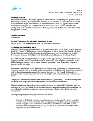
Item 16 Water & Wastewater Commission: May 21, 2025 Council: June 5, 2025 ..Title Posting Language Recommend approval to authorize the negotiation and execution of a cost participation agreement with JCI Multifamily, LP for the City to reimburse the developer for an amount not to exceed $897,000.00 for costs associated with the design and construction of oversized wastewater mains and appurtenances related to Service Extension Request No. 5442R that will provide wastewater service to proposed multifamily developments located at 14709 Immanuel Road. Funding is available in the Fiscal Year 2024-2025 Capital Budget of Austin Water. .De Lead Department Austin Water. Council Committee, Boards and Commission Action: May 21, 2025 – To be reviewed by the Water and Wastewater Commission. Additional Backup Information: The Weiss Tract Subdivision project consists of approximately 111 acres of land located at 14709 Immanuel Road (the “Property”). The Property is located entirely within the City of Austin’s (the “City”) 2-mile Extra- Territorial Jurisdiction, Impact Fee Boundary, Austin Water’s service area for wastewater, the Desired Development Zone, and the Gilleland Creek Watershed. A map of the property location is attached. JCI Multifamily, LP (the “Applicant”) is proposing to develop approximately 2,200 multi-family units. The Applicant requested that the City provide wastewater utility service to the Property as proposed in Service Extension Request (SER) No. 5442R. Austin Water will provide retail water service to the Property as proposed in SER No. 5441R. In accordance with Chapter 25-9 of the City Code, the City has asked the Applicant to oversize the gravity wastewater mains in order to serve additional properties within the Gilleland Creek drainage basin consistent with the City’s long range planning goals for this area. If approved by City Council, the City will cost participate in this construction project only to the extent of the City’s proportionate share of the oversized mains. The proposed oversized improvements include construction of approximately 1,135 feet of 24-inch gravity wastewater main along Crystal Bend Drive between Dessau Road and Immanuel Road. The City will reimburse the Applicant for an overall total amount not to exceed $897,000.00 for hard costs and soft costs. Hard costs include, but are not limited to, construction and materials. Soft costs include, but are not limited to, preliminary engineering reports, surveying, geotechnical studies, design, and project management The City’s cost participation by project component is as follows: • For costs of the 24-inch wastewater mains (the minimum pipe diameter of 18-inches required to serve the Property to an oversized 24-inch) and appurtenances, the City’s maximum participation consists of: (1) hard costs, in an amount not to exceed 25% of the hard costs of the 24-inch wastewater mains and appurtenances, and (2) soft costs, in an amount not to exceed 15% of the City’s hard cost participation amount. Item 16 Water & Wastewater Commission: May 21, 2025 Council: June 5, 2025 To serve the Property, the Applicant will additionally be required to construct, at their own cost: • 850-gpm pumping capacity lift station located east of the Property; • Approximately 2,750 feet of appropriately sized gravity wastewater mains from the lift station to proposed lots within the Property; and • Approximately 5,750 feet of appropriately sized wastewater force main from the lift station south through the Property and along Immanuel Road to Crystal Bend Drive Other terms of the agreement will require that the Applicant: • Pay all costs for financing, interest, fiscal security, accounting, insurance, inspections, permitting, easement acquisition, legal services, and other non-reimbursable soft costs associated with the project; • Conform to the City’s design criteria and construction standards; • Construct all improvements at their cost and, after the City’s final approval of the construction, dedicate the facilities to the City for ownership, operation, and maintenance; • Allow the City to use the project plans and specifications approved by the City to solicit and publish invitations for bids for the construction of the improvements; and • Follow the City’s standard bidding practices and procedures, including the minority-owned business enterprise procurement program found in Title 2 of the City Code, and Texas Local Government Code Chapters 212 and 252. The proposed project will be managed through Austin Water staff and is located in zip code 78660, near City Council District 1. W O LY M PIC D R T H S T 0 S 1 P36 P35 P34 MAIER DR FIS H L N D U R A S S E D P33 HUNTERS RILL WAY P32 E YA G E R L N Item 16 R36 R35 R34 LOCATION MAP Weiss Tract Subdivision (Revised) Wastewater SER-5442R Q36 C R ET E L N L O R A N T L N M A S E R E GIC HILL D NIT Y D R R D L R E U N A M IM KILLIN G S W O R T H L N Q35 Q34 SHIMSHAM DR TA R L B E N D D R C R Y S PIA D M LY O R G D RIDIN Q32 Feet 6,000 O RTM A N D R T K S R E L C E H O W A R D L N K I L L I N G S W O R T H L N R33 Q33 D N R O R E M A C GRID Subject Tract Full-Purpose City Limit R32 2-Mile ETJ City of Pflugerville Pflugerville ETJ Unincorporated Travis County G L E N G G R This product is for informational purposes and may not have been prepared for or be suitable for legal, engineering, or surveying purposes. It does not represent an on-the-ground survey and represents only the approximate relative location of property boundaries. This product has been produced by the City of Austin for the sole purpose of geographic reference. No warranty is made by the City of Austin regarding specific accuracy or completeness. 4/26/2025 / 0 1,000 2,000 4,000 Item 16 %%%%%%%%%%%%%%%%%%%%%%%%%%%%%%%%%%%%%%%%%%%%%%%%%%%%%%%%%%%%%%%%%%%%%%%%%%%%%%%%%%%%%%%%%%%%%%%%%%%%%%%%%%%%%%%%%%%%%%%%%%%%%%%%%%%%%%%%%%%%%%%%%%%%%%%%%%%%%%%%%%%%%%%%%%%%%%%%%%%%%%%%%%%%%%%%%%%%%%%%%%%%%%%%%%%%%%%%%%%%%%%%%%%%%%%%%%%%%%%%%%%%%%%%%%%%%%%%%%%%%%%%%%%%%%%%%%%%%%%%%%%%%%%%%%%%%%%%%%%%%%%%%%%%%%%%%%%%%%%%%%%%%%%%%%%%%%%%%%%%%%%%%%%%%%%%%%%%%%%%%%%%%%%%%%%%%%%%%%%%%%%%%%%%%%%%%%%%%%%%%%%%%%%%%%%%%%%%%%%%%%%%%%\\\\\\%%%\\\\\\\\\\\\\\\\\\\\\%\%\%%\\\\\\\\\\\\\\%%%%%%%%\\\\\\\\\\\\\\\\\\\\\\\\\\\\\\\\\\\\\\\\\\\\\\\\\\\\\\\\\\\\\\\\%\%\%\%\%\\\%%%%%\\\\\\\\\\\\\\\\\\\\\\\\\\\\\\\\\\\%\%\%%\\\\\\\\\\%%\\\\\\\\\\\\\\\%%%\\\\\\\\\\\\\\\\\\\%\%%\\\\\\\\\\\\\\\%\\\%\\\\\%\\\\!%!!!!!!!!!!!!!%!%!!!%!!!!!!!!!%!!!!!!!%!!!%!!!%!!%!!!!!%!!!!!!!%!!!!%!!!%!!!!!%!!!!!!!%!!!!!!!!!!%!!!!!!!%!!!!%!!!!%!!!!!%!!%!!!!%!!!!!!%!!!!!%!!!!!%!!!%!!!%!!%!!!!!!%!!!!%!!!!!%!!!!!!%!!%!!%!!!!!!!!!!%!!%!!%!!!%!!!%!!!!!!!!!!%!!%!!!!!%!!!!!!!%!!!!!%!!!%!!!%!!!!!!!!!!%!!!%!!!!%!!!!!!!!!!!!%!!!!!!!!!!!!%!!!!!!!!!!!!!!!!!!!!!!!!%!!!!!!!!!!!!%!!!%!!!!!!!%!!%!!%!!!!!!%!!!!!!%!%!!!%!!!%!%!!!!!!!!!%!!!!!!!!!!!!!!!!!!%%!!!!!!!!!!!!!!!%!!!!!!!!%!!!!!!!%!!!!!!!!%!!%!!!!!!!!!%!!!!%!%!!!!!!!!!%!!!!!%!!%!%!!%!%!!%!!!!!!!!!%!!!%!%!!%!%%%(((((((((((%(%(%(((((%%%%(((((((((%%((((((((((%%%((((((((((%%(((((((((%(((((%%%%((((((((((%%%%%%%\\\\%\%\\\\\\%%\\\\\\\\\\\\\\%\\%\\\\\%%%%\\\\\\\\\\\\\\\\\\\\\\\\\\%%%%\\\\\\\\\\\\\\\\\\\\\\\\\\%\%%\\\\\\\\\\\\\\\\%\\\%\\\\\\\%%%%%\\\\\\\\\\\\\\\\\\\\\\\\\\\\\\\\\\\\%\\\!P!P!P!P!P!P!P!P!P!P!P!P!P!P!P!P!P!P!P!P!P!P!P!P!P!P!P!P!P!P!P!P!P!P!P!P!P!P!P!P!P!P!P!P!P!P!P!P!P!P!P!P!P!P!P!P!P!P!P!P!P!P!P!P!P!P!P!P!P!P!P!P!P!P!P!P!P!P!P!P!P!P!P!P!P!P!P!P!P!P!P!P!P!P!P!P!P!P!P!P!P!P!P!P!P!P!P!P!P!P!P!P!P!P!P!P!P!P!P!P!P!P!P!P!P!P!P!P!P!P!P!P!P!P!P!P!P!P!P!P!P!P!P!P!P!P!P!P!P!P!P!P!P!P!P!P!P!P!P!P!P!P!P!P!P!P!P!P!P!P!P!P!P!P!P!P!P!P!P!P!P!P!P!P!P!P!P!P!P!P!P!P!P!P!P!P!P!P!P!P!P!P!P!P!P!P!P!P!P!P!P!P!P!P!P!P!P!P!P!P!P!P!P!P!P!P!P!P!P!P!P!P!P!P!P!P!P!P!P!P!P!P!P!P!P!P!P!P!P!P!P!P!P!P!P!P!P!P!P!P!P!P!P!P!P!P!P!P!P!P!P!P!P!P!P!P!P!P!P!P!P!P!P!P!P!P!P!P!P!P!P!P!P!P!P!P!P!P!P!P!P!P!P!P!P!P!P!P!P!P!P!P!P!P!P!P!P!P!P!P!P!P!P!P!P!P!P!P!P!P!P!P!P!P!P!P!P!P!P!P!P!P!P!P!P!P!P!P!P!P!P!P!P!P!P!P!P!P!P!P!P!P!P!P!P!P!P!P!P!P!P!P!P!P!P!P!P!P!P!P!P!P!P!P!P!P!P!P!P!P!P!P!P!P!P!P!P!P!P!P!P!P!P!P!P!P!P!P!P!P!P!P!P!P!P!P!P!P!P!P!P!P!P!P!P!P!P!P!P!P!P!P!P!P!P!P!P!P!P!P!P!P!P!P!P!P!P!P!P!P!P!P!P!P!P!P!P!P!P$.$.$.$.$.$.$.$.$.$.$.$.$.$.$.$.$.$.$.$.$.$.$.$.[7L[7L[7L[7L[7L[7L[7L3TP!¬GIMMANUEL RDDESSAU RDCRYSTAL BEND DRCRYSTAL BEND DRSPINEL RDFISH LNMILLHOUSE DRLOURIS LNE WELLS BRANCH PKWYKILLINGSWORTH LNKODIAK LNE HOWARD LNE OLYMPIC DRPURPLE MARTIN DRPURPLE MARTINDRST PATRICKS PLENTRADA TRANQUILA WAYSKYLARK HILL LNSKYLARK HILL LNON FORGE RDCLANCY WAYSYLVIPIGEA LNHONEY CVE PFENNIGLNALANA FALLSAVEALDING VALLEYDRIMMANUEL RD690700710680670660650720730640630740620750760610770740650680690640610720690680710670620690720670730710720640700700690670690670680690750700720630670690710690700660640730720700680620710680700710660730740690700710630710680700620P34P35Q35Q34P33Q33GREGGLANELSFORTDESSAULSTREYVONCOURTLSEntrada Lift StationDESSAUWWTPINFLUENTLIFTSTATIONDESSAUWWTP20219510"PE6"PVC24"PVC8"PVC8"DI12"PVC15" PVC16"DI8" PVC8"PVC8"PVC8"PVC8"PVC8"PVC8"PVC8"PVC8"PVC10"PE8"PVC8" PVC8"PVC6"PVC8"PVC8"PVC8"PVC8"PVC8"PVC8"PVC8"PVC8"PVC8"PVC8"PVC8"PVC6"PVC8"PVC8"DI12"PVC12"PVC8"DI8"PVC8"PVC12"PVC10"PE8"PVC8"PVC8" PVC8"PVC8"PVC8"PVC8"PVC8"PVC8" PVC8"DI10"PE8"PVCPRIVATE LIFT STATIONW.W. S.E.R. Name: Weiss Tract Subdivision (Revised)Wastewater SER-5442ROversized Improvements Map.Utility Development Services Plotted 4/22/202501,0002,0003,000500FeetSubject TractEntrada Subdivision100-yr FEMA FloodplainCritical Water Quality ZoneFull-Purpose City Limit2-Mile ETJPflugerville City LimitsPflugerville ETJThis product is for informational purposes and may not have been prepared for or be suitable for legal, engineering, or surveying purposes. It does not represent an on-the-ground survey and represents only the approximate relative location of the property boundaries. This product has been produced by the City of Austin for the sole purpose ofgeographic reference. No warranty is made by the City of Austin regarding specific accuracy or completeness.?STAFF PROPOSED APPROXIMATELY485 FEET OF OVERSIZED 24-INCHWASTEWATER INTERCEPTOR?STAFF PROPOSED APPROXIMATELY650 FEET OF OVERSIZED 24-INCHWASTEWATER INTERCEPTOR?STAFFPROPOSEDAPPROXIMATELY2,750FEETOFAPPROPRIATELYSIZEDGRAVITYWASTEWATERMAINSTAFF PROPOSEDAPPROXIMATELY 5,750 FEETOF APPROPRIATELY SIZEDFORCE MAINSTAFFPROPOSEDAPPROXIMATELY1,500FEETOF8-INCHGRAVITYWASTEWATER MAIN(APPROX. 250 LUE)STAFF PROPOSEDAPPROPRIATELY SIZEDLIFT STATION