Item 5 — original pdf
Backup
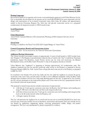
Item 5 # 23-3647 Water & Wastewater Commission: January 17, 2024 Council: January 18, 2024 Posting Language Recommend approval to negotiate and execute a cost participation agreement with Urban Moment for the City to reimburse the developer for an amount not to exceed $3,220,000.00 for costs associated with the design and construction of an oversized wastewater main, force main, lift station, and appurtenances related to Service Extension Request No. 5646 that will provide wastewater service to a proposed condominium development located at 12905 Lowden Lane. Lead Department Austin Water Client Department Austin Water Assistant Director of Environmental, Planning and Development Services, Kevin Critendon Fiscal Note Funding is available in the Fiscal Year 2023-2024 Capital Budget of Austin Water. Council Committee, Boards and Commission Action January 17, 2024 - To be reviewed by the Water & Wastewater Commission. Additional Backup Information The Urbana Lowden Lane project consists of approximately 14 acres of land located at 12905 Lowden Lane (the “Property”). The Property is located entirely within the City of Austin’s (the “City”) 2-mile Extra-Territorial Jurisdiction, Impact Fee Boundary, Austin Water’s service area for water and wastewater, the Desired Development Zone, and the Bear Creek Watershed. A map of the property location is attached. Urban Moment (the “Applicant”) is proposing to develop approximately 165 condominium units. The Applicant requested that the City provide wastewater utility service to the Property as proposed in Service Extension Request (SER) No. 5646. Austin Water will provide retail water service to the Property as proposed in SER No. 5645. In accordance with Chapter 25-9 of the City Code, the City has asked the Applicant to oversize the gravity wastewater main, force main, and lift station in order to serve additional properties within the Bear Creek drainage basin consistent with the City’s long range planning goals for this area. If approved by City Council, the City will cost participate in this construction project only to the extent of the City’s proportionate share of the oversized wastewater improvements. The proposed oversized improvements include construction of approximately: • 1,400 feet of 15-inch gravity wastewater main from the Rancho Alto Lift Station and extending east along W. FM 1626 to Lowden Lane and then south along Lowden Lane, • 3,900 feet of force main from the 15-inch gravity wastewater main and extending south along Lowden Lane to the lift station located within the Property, and a 200-gpm capacity lift station. • The City will reimburse the Applicant for an overall total amount not to exceed $3,220,000.00 for hard costs and soft costs. Hard costs include, but are not limited to, construction and materials. Soft costs include, but are not limited to, preliminary engineering reports, surveying, geotechnical studies, design, and project management. The City’s cost participation by project component is as follows: Item 5 # 23-3647 Water & Wastewater Commission: January 17, 2024 Council: January 18, 2024 • For costs of the 15-inch gravity wastewater main (the minimum pipe diameter of 8-inches required to serve the Property to an oversized 15-inch) and appurtenances, the City’s maximum participation consists of: (1) hard costs, in an amount not to exceed 47% of the hard costs of the 15-inch gravity wastewater main and appurtenances, and (2) soft costs, in an amount not to exceed 15% of the City’s hard cost participation amount. • For costs of the lift station and wastewater force main (the minimum capacity of 88-gpm required to serve the Property to an oversized capacity of 200-gpm) and appurtenances, the City’s maximum participation consists of: (1) hard costs, in an amount not to exceed 56% of the hard costs of the lift station, wastewater force main, and appurtenances, and (2) soft costs, in an amount not to exceed 15% of the City’s hard cost participation amount. To serve the Property, the Applicant will additionally be required to construct, at their own cost: • • • approximately 1,100 feet of 8-inch gravity wastewater main from the lift station and extending west within the Property to Lowden Lane, a capacity upgrade to the existing Ranch Alto Lift Station, and approximately 275 feet of 12-inch gravity wastewater main along Jim Thorpe Lane from Johnny Weismuller Lane to Frate Barker Road. Other terms of the agreement will require that the Applicant: • Pay all costs for financing, interest, fiscal security, accounting, insurance, inspections, permitting, easement acquisition, legal services, and other non-reimbursable soft costs associated with the project; • Conform to the City’s design criteria and construction standards; • Construct all improvements at their cost and, after the City’s final approval of the construction, dedicate the facilities to the City for ownership, operation, and maintenance; • Allow the City to use the project plans and specifications approved by the City to solicit and publish invitations for bids for the construction of the improvements; and • Follow the City’s standard bidding practices and procedures, including the minority-owned business enterprise procurement program found in Title 2 of the City Code, and Texas Local Government Code Chapters 212 and 252. The proposed project will be managed through Austin Water staff and is located in zip code 78652, near Council Districts 5 and 8. D13 RAVENSCROFT DR HILLHAVEN DR LOCATION MAP Urbana Lowden Lane Wastewater SER-5646 E13 R D N O I N E P W ENS DR R D B U D JESSE O CATALAN RD D12 FRATE BARKER RD B U S T E R C R A B B E D R I E R C H E D E N C T I H E W T T I L N D R O T L A O H C N A R V E R C H O T A D R R D E N O Z U R E I B U Z Z S C H N E I D E R L N H CIR UTA R D A L L E V R A N B L A C K B N L R E P P O T E A R D B E A R R C R E E K N L N E D W O L B R O D I E L N R D N O S R U B D11 O L I V E R S W A Y R D A K T I D L P S T R O M D R N O S N H O J B O B NANDI ST LARRYS LN N S L K C D10 O D IL L O G D9 D8 HAYS COUNTY M E N C H A C A R D S I R T H O P A S T R L CHAPPELL LN M A Y O S T S U S J O Y S T E S T I E A S Y S T ZACHARYS WAY REGAL ROW M A N C H A C A R D N L S E L U O S D R K L O P W FM 1626 RD E V A E N O T S R E P P O C E11 S L A U G H T E R C R E E K D R R D X O F L U F H C T A W F12 K I N G C S A E F I S H R A I S H M E E A R T I C O L N L N R C R E E K R D R A C E T R A C K D R REDBUD TRL SAN LEANNA DR N L Y T A K E12 R I V E R O A K S D R RIDGE DR R T D E S N U S C H A P E L L N R D E L C R C I F13 SLAUGHTER CREEK T T S S S 1 WAYNE RIDDELL LOOP R D K O O R B H S A E FM 1626 RD N Y L O R N O C F11 N H L A R R A F B E T H E L C H U R C H R D B L U E B O N N E T L N L R T L E N N U T TRAVIS COUNTY R D L I A T R O S S I C S E L M V A L L E Y D R T W N I C R E E K D R M I S T L E T O E T R L C H O L L A L N ARROYO VISTA DR E10 WHITETAIL DR S E C T O N I H O U S E R D GARLIC CREEK R E D L B O O D Y O R R A E9 CORONILLA BND A LL E N D E B N D T O L U C A D R R O D R E D A M M O R ELIA W A Y O L D S A N A N T O N O R D I Y W K A P CI N A T S E AZAR AVE R A D ALC N O L P M PA B 5 N S IH 3 B D N R V B 5 S D S S IH 3 R V 5 S S IH 3 F9 FM 1327 RD PURYEAR RD S SH 45 E EB GRID Subject Tract Full-Purpose City Limit B Limited-Purpose City Limit 5 S S IH 3 2-Mile ETJ Village of San Leanna F8 Buda ETJ County Boundary TWIN CREEKS RD F10 M I S S I O W I N D Y G A N R I V E P D R D R R I R D C T S Y M R O D CIN N E TUR LEY DR ONION CREEK DR HARRAH DR BOLEY DR STEEL TIMBER DR E A S L E Y D R I W L D T U R K E Y D R O N I O N C R E E K E8 / 0 1,000 2,000 4,000 Feet 6,000 This product is for informational purposes and may not have been prepared for or be suitable for legal, engineering, or surveying purposes. It does not represent an on-the-ground survey and represents only the approximate relative location of property boundaries. This product has been produced by the City of Austin for the sole purpose of geographic reference. No warranty is made by the City of Austin regarding specific accuracy or completeness. 12/5/2023 %%%%%%%%%%%%%%%%%%%%%%%%%%%%%%%%%%%%%%%%%%%%%%%%%%%%%%%%%%%%%%%%%%%%%%%%%%%%%%%%%%%%%%%%%%%%%%%%%%%%%%%%%%%%%%%%%%%%%%%%%%%%%%%%%%%%%%%%%%%%%%%%%%%%%%%%%%%%%%%%%%%%%%%%%%%%%%%%%%%%%%%%%%%%%%%%%%%%%%%%%%%%%%%%%%%%%%%%%%%%%%%%%%%%%%%%%%%%%%%%%%%%%%%%%%%%%%%%%%%%%%%%%%%%%%%%%%%%%%%%%%%%%%%%%%%%%%%%%%%%%%%%%%%%%%%%%%%%%%%%%%%%%%%%%%%\\\\\\\\\\\\\\\\\\\\\\\\\\\\\\\\\\\\\\\\%\\\%%\\\\\\\\\\!%!!!!!!!!!!!!!!!!!!%%!!!!!!!!!!!!!!!%!!!!!!!!!!!%!%%\\%\\[7L[7L!P!P!P!P!P!P!P!P!P!P!P!P!P!P!P!P!P!P!P!P!P!P!P!P!P!P!P!P!P!P!P!P!P!P!P!P!P!P!P!P!P!P!P!P!P!P!P!P!P!P!P!P!P!P!P!P!P!P!P!P!P!P!P!P!P!P!P!P!P!P!P!P!P!P!P!P!P!P!P!P!P!P!P!P!P!P!P!P!P!P!P!P!P!P!P!P!P!P!P!P!P!P!P!P!P!P!P!P!P!P!P!P!P!P!P!P!P!P!P!P!P!P!P!P!P!P!P!P!P!P!P!P!P!P!P!P!P!P!P!P!P!P!P!P!P!P!P!P!P!P!P!P!P!P!P!P!P!P!P!P!P!P!P!P!P!P!P!P!P!P!P!P!P!P!P!P!P!P!P!P!P!P!P!P!P!P!P!P!P!P!P!P!P!P!P!P!P!P!P!P!P!P!P!P!P!P!P!P!P!P!P!P!P!P!P!P!P!P!P!P!P!P!P!P!P!P!P!P!P!P!P!P!P!P!P!P!P!P!P!P!P!P!P!P!P!P!P!P!P!P!P!P!P!P!P!P!P!P!P!P!P!P!P!P!P!P!P!P!P!P!P!P!P!P!P!P!P!P!P!P!P!P!P!P!P!P$.$.$.$.STAFF PROPOSEDUPGRADE EXISTINGLIFT STATIONSTAFF PROPOSEDAPPROXIMATELY 3,900 FEETOF OVERSIZED FORCE MAINSTAFF PROPOSEDAPPROXIMATELY 1,400 FEET OFOVERSIZED 15-INCH GRAVITYWASTEWATER MAIN(MINIMUM 0.3% SLOPE)STAFF PROPOSEDAPPROXIMATELY 275 FEETOF 12-INCH GRAVITYWASTEWATER MAINSTAFF PROPOSEDOVERSIZEDLIFT STATIONSTAFF PROPOSEDAPPROXIMATELY 1,100 FEETOF 8-INCH GRAVITYWASTEWATER MAINW FM 1626 RDLOWDEN LNTWIN CREEKS RDFRATE BARKER RDCHOLLA LNMISTLETOE TRLEASY STWIRTH RDBURSON DRRANCHO ALTO RDTOPPER LNCHAPEL LNDEANE RDO CALLAHAN DRBROTEN STTWIN CREEK DRBLACK BEAR DRMOORELAND DRERUZIONE DRBETHEL CHURCH RDBUZZ SCHNEIDER LNBOB JOHNSON RDFALCONER WAYJENKINS BNDJOY STARROYO VISTA DRBROWN BEAR LNMARISCAN STGOLDILOCKS LNMEREDITH DRCATALAN RDNANDI STPANDA LNCOPPER SPRING DRLARRYS LNJIM THORPE LNST STANISLAWS DRSUSIE STHICKORY RIDGE RDMAYO STKOALA STAIREDALE RDNARVELLA DRJOHNNY WEISMULLER LNSOULES LNINDIAN TREE TRLSUTER STROBERT WOODING DRSTROBEL LNMARCUS ABRAMS BLVD2ND STMC CLANNAHAN DRDAVE SILK DREDGEBROOK DRPAVELICH PASSVERCHOTA DRCHRISTOFF LOOPUTAH CIRSPARKLE DROLD MANCHACA RDEL PAISANO LNHALAS STLUCKMAN LNBILLY MILLS LNBRIGGS DRRALPH COX RDBILL BAKER DRARNOLD LNJOHNSON LNCRAIG PATRICK WAYJAMES HALLER DRJIM CRAIG CTTENON CVSTEN BERGMAN DRJESSE OWENS DRHERB BROOKS DRRIDGE DRSLAUGHTER CREEK DRTHERESA BLANCHARD LNKOOLIE LNMARY HARGROVE LNDOUBLE ELM DRRIVER OAKS DRBRUCE JENNER LNLIMESTONE SHOALS RDAUBURN STEM PLVIRIDIAN BRANCH CTHUNTING CREEK LNELM VIEW WAYSUNSET DRMC MAHON LNLITTLE BEAR CVTWIN CREEK CVBUDLEY S DEGROOT LNARROYO VISTA DRMENCHACA RD650670660680690640630700710720620730610740610640690670700670680670650690680640630660690630640710690630610670680620630710650640630610700680640660670640670670650680660690630BEAR CREEKD11E11D12E12D10E10RANCHO ALTO LSHILLS OF BEAR CREEK LS19215754" RCP8" PVC12" PVC8" PVC8" PVC8" PVC8" PVC12" PVC8" PVC8" PVC8" PVCRANCHO ALTO LSHILLS OF BEAR CREEK LSW.W. S.E.R. Name: Urbana Lowden LaneWastewater SER-5646Oversized Improvements Map.Utility Development Services Plotted 12/4/202301,0002,0003,000500FeetSubject Tract100-yr FEMA FloodplainCritical Water Quality ZoneFull-Purpose City Limit2-Mile ETJVillage of San LeannaThis product is for informational purposes and may not have been prepared for or be suitable for legal, engineering, or surveying purposes. It does notrepresent an on-the-ground survey and represents only the approximate relative location of the property boundaries. This product has been produced by theCity of Austin for the sole purpose of geographic reference. No warranty is made by the City of Austin regarding specific accuracy or completeness.223457137521137523