Item 17 — original pdf
Backup
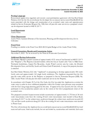
Item 17 # 22-3442 Water &Wastewater Commission: November 9, 2022 Council: December 8, 2022 Posting Language Recommend approval to negotiate and execute a cost participation agreement with Kor Real Estate Partners, LLC for the City to reimburse the developer for an amount not to exceed $4,680,000.00 for costs associated with the design and construction of an oversized water main and appurtenances related to Service Extension Request No. 5206 that will provide water service to a proposed mixed- use development located at 4400 E. SH 71. Lead Department Austin Water Client Department Austin Water Assistant Director of Environment, Planning and Development Services, Kevin Critendon Fiscal Note Funding is available in the Fiscal Year 2022-2023 Capital Budget of the Austin Water Utility Council Committee, Boards and Commission Action November 9, 2022 - To be reviewed by the Water & Wastewater Commission Additional Backup Information The Barkley Meadows project consists of approximately 43.91 acres of land located at 4400 E. SH 71 (the “Property”). The Property is located entirely within the City of Austin’s (the “City”) 2-Mile Extra- Territorial Jurisdiction, Impact Fee Boundary, Austin Water’s service area for water, the Desired Development Zone, and the Dry South and Onion Creek Watersheds. A map of the property location is attached. Kor Real Estate Partners, LLC (the “Applicant”) is proposing to develop approximately 450 multi- family units and approximately 165 single family residences. The Applicant requested that the City provide water utility service to the Property as proposed in Service Extension Request (SER) No. 5206. Austin Water will also provide retail wastewater service to the Property. In accordance with Chapter 25-9 of the City Code, the City has asked the Applicant to oversize the water main in order to serve additional properties within the Central water pressure zone consistent with the City’s long range planning goals for this area. If approved by City Council, the City will cost participate in this construction project only to the extent of the City’s proportionate share of the oversized main. The proposed oversized improvements include construction of approximately 11,755 feet of 24-inch water transmission main from the existing 24-inch water transmission main located in Ross Road, west along E. SH 71 to the subject tract, southwest through the subject tract, northwest towards SH 130, and then south-southwest along SH 130 to the existing 24-inch water transmission main located in Pearce Lane. The City will reimburse the Applicant for an overall total amount not to exceed $4,680,000.00 for hard costs and soft costs. Hard costs include, but are not limited to, construction and materials. Soft costs Item 17 # 22-3442 Water &Wastewater Commission: November 9, 2022 Council: December 8, 2022 include, but are not limited to, preliminary engineering reports, surveying, geotechnical studies, design, and project management. The City’s cost participation by project component is as follows: • For costs of the 24-inch water main (the minimum pipe diameter of 12 inches required to serve the Property to an oversized 24-inch) and appurtenances, the City’s maximum participation consists of: (1) hard costs, in an amount not to exceed 50% of the hard costs of the 24-inch water transmission main and appurtenances, and (2) soft costs, in an amount not to exceed 15% of the City’s hard cost participation amount. Other terms of the agreement will require that the Applicant: • Pay all costs for financing, interest, fiscal security, accounting, insurance, inspections, permitting, easement acquisition, legal services, and other non-reimbursable soft costs associated with the project. • Conform to the City’s design criteria and construction standards. • Construct all improvements at their cost and, after the City’s final approval of the construction, dedicate the facilities to the City for ownership, operation, and maintenance. • Allow the City to use the project plans and specifications approved by the City to solicit and publish invitations for bids for the construction of the improvements; and • Follow the City’s standard bidding practices and procedures, including the minority-owned business enterprise procurement program found in Title 2 of the City Code, and Texas Local Government Code Chapters 212 and 252. The proposed project will be managed through Austin Water staff and is located in zip code 78617, adjacent to City Council District 2. Strategic Outcome(s) Government that Works for All LOCATION MAP Barkley Meadows Water SER-5206 C O L O R A D O R I V E R L L N L L W E F A L Q17 B N 0 3 1 H S S P17 ELL O N R D D R 3 7 9 M F S E S E V A S T M A R H 71 S E V A S T Y S T V R D W B GUERRERO DR E S H 71 W B DIO N D A LN E S H 71 S V R D E B P16 S PIRIT D R Q16 R16 3 B D S R V 0 S H 1 S S B D N B R 0 S V 0 S H 1 H 1 S S S S 3 3 Q15 D O L S R H D E L R P T D H I F R U E D A S R D T A V I R A D R S AIN T T H O M A S D R M A RIO D R IGL E SIA S DR REVA R D R X D O R F E V SIL Q14 Q UIRIN D R D S R S O R LA G U A R DIA LN D S S R O R P A L S K O M C A M Y H A B A R L A P E A R C B U E N O E L N S AIR P A N B O A D R R D R N C A W AZ LN A Y LA P D Y R R N D E V K R C E R G Y A A E A L M H W M A NIJ M O L A S L E W P O O L N O T P I L E S P K W Y D E A R B O N N E D R R D N A H A B GIL W ELL D R S E A A BIS LY S H C C O O E B M E UIT D A D R R S D R R D E Y O T D R Y C R E E K E A S T Q13 P15 R S D R S O D E N K LIC A E PIM R P P14 F O L E Y D R Basemap Polygon Street Names GRID Railroad Subject Tract P13 R T D S Austin Impact Fee Boundary E R S C AIN L P Limited-Purpose City Limit Full-Purpose City Limit 2-Mile ETJ / 0 R17 O NIO N C R E E K R T D T O C R S O T C O D R H D C R U B E S H 7 1 E B R15 KELLA M RD R14 R13 1,000 2,000 4,000 Feet 6,000 This product is for informational purposes and may not have been prepared for or be suitable for legal, engineering, or surveying purposes. It does not represent an on-the-ground survey and represents only the approximate relative location of property boundaries. This product has been produced by the City of Austin for the sole purpose of geographic reference. No warranty is made by the City of Austin regarding specific accuracy or completeness. 10/13/2022 0 4 4 0 5 4 0 6 4 0 4 4 0 4 4 4 3 0 440 Q16 0 4 4 4 3 4 3 0 ONION CREEK WILDLIFE SANCTUARY 0 5 1 0 0 4 4 4 3 0 0 3 4 0 2 4 410 400 390 0 8 4 4 7 0 4 2 0 0 1 5 54 0 0 2 5 5 3 0 5 2 0 5 0 0 5 1 0 490 490 500 4 9 0 490 5 0 0 5 1 0 8" 8" 0 9 4 4 9 0 2 4 " 4 9 0 8" 480 D S R 5 1 0 S O R 12" 12" ! ! ! ! ! ! ! ! ! ! ! ! ! ! ! ! ! ! ! ! ! ! ! ! ! ! ! ! ! ! ! ! ! ! ! ! ! !!! ! ! ! ! !!! ! STAFF PROPOSED APPROXIMATELY 11,755 FEET OF OVERSIZED 24-INCH WATER TRANSMISSION MAIN ! !!! ! ! ! ! ! ! ! ! ! ! ! ! ! ! ! ! ! ! ! ! !! ! ! ! ! ! ! ! ! ! ! ! ! ! ! ! ! ! ! ! ! ! ! ! ! ! ! ! ! ! ! ! ! ! ! ! ! ! ! ! ! ! ! ! ! ! ! ! ! ! ! ! ! ! ! ! ! ! ! ! ! ! ! ! ! ! ! ! ! ! ! ! ! ! ! ! ! ! ! ! ! ! ! ! ! ! ! ! ! ! 8" 8" ! ! ! 12" P16 8 " 12" ! ! ! ! ! ! ! !! ! ! ! ! ! ! ! ! ! ! ! ! ! 12" ! ! ! ! ! ! ! ! ! ! ! ! ! ! ! ! ! ! ! ! ! ! ! ! ! ! ! ! ! ! ! ! 4 5 0 450 ! ! ! ! ! ! ! ! ! ! ! ! ! ! ! ! ! ! ! ! ! ! ! ! ! ! ! ! ! ! 12" ! ! ! ! ! ! ! ! ! ! ! ! ! ! !! ! ! ! ! 12" ! ! ! ! ! ! ! ! ! ! ! ! ! ! ! ! ! ! ! ! ! ! ! ! ! ! 4 5 0 440 0 4 4 4 4 0 ! ! ! ! ! ! ! ! ! ! 0 6 4 ! ! ! ! ! ! ! ! ! ! ! ! ! ! ! ! STAFF PROPOSED EASEMENT FOR FUTURE 24-INCH WATER TRANSMISSION MAIN 0 5 4 0 6 4 0 4 4 410 4 4 0 4 4 0 0 4 3 0 2 4 410 E S H 7 1 420 430 4 3 0 430 0 2 4 O R M G 4 5 0 0 3 4 0 4 4 430 U P, L.P. 45 0 450 450 S S H 130 4 4 0 0 6 4 430 0 2 4 ! 8 ! ! ! ! ! ! ! ! ! ! ! ! ! ! 8 ! ! ! ! ! ! ! ! ! ! ! " ! ! ! ! ! ! ! ! ! ! ! ! ! ! ! ! ! " ! !! ! ! ! ! ! ! ! ! ! ! ! ! ! ! ! ! ! ! ! ! ! ! ! ! ! ! ! ! ! ! ! ! !!!! ! ! ! ! ! ! ! ! ! ! ! ! ! ! 4 4 0 ! ! ! ! ! ! ! ! ! ! ! ! !! ! ! !! ! ! !!! ! ! ! ! ! ! ! ! Q15 0 8 4 0 0 5 8" 12" 8" 8" 6" 6" 450 1 2 " 8" " 8 6" 24" PEA R C 500 E LN 500 490 8" ! ! !! ! ! ! ! ! ! ! ! ! !! ! ! ! ! ! ! ! ! ! ! ! ! ! ! ! ! ! ! ! ! ! ! ! ! ! ! ! ! 8" ! ! ! ! ! 16" ! ! ! ! ! ! ! ! ! ! 4" ! ! ! ! ! !! ! ! ! 12" 8" ! ! ! ! ! ! ! ! ! ! ! ! ! 8 ! ! ! " ! ! ! ! ! ! ! ! ! 8 ! ! ! ! " ! ! ! ! ! ! ! ! ! ! ! ! ! 8" ! ! ! ! ! ! ! ! ! ! 8" 4" 0 8 4 12" ! ! ! !! ! ! ! 6 " 8" " 8 ! ! ! ! ! ! ! ! ! 4 9 0 ! ! ! ! ! 8" ! ! ! ! ! ! 6" 8" 1 6" 1 6" 8" 8" 8 " 8" 8" ! ! ! ! ! ! ! ! ! ! ! ! ! ! ! ! ! ! ! ! ! ! ! ! ! 0 7 4 490 12" 8" 8" 480 8" 12" 8" 8" ! ! ! ! ! ! 8" 8" 8" 8" 8 " DRY CREEK GREENBELT 0 6 4 4 5 0 450 P15 420 " 6 0 3 4 0 4 4 8" 6" 8" 0 4 4 4 4 0 H P E T R C 8 " K O 24" 440 P14 470 460 480 5 1 0 5 0 0 4 7 0 430 O L E U 4 6 0 ÍÎ$³ 0 7 4 4" 5 0 0 4 6 0 P13 ! ! ! ! ! 36" ! ! ! ! ! ! ! ! ! ! ! ! ! ! ! ! ! ! ! ! ! ! 750 ! ! ! ! ! ! ! . W. S.E.R. Name: Barkley Meadows W. S.E.R. Number: 5206 Utility Development Services Plotted 10/19/2022 0 1,500 3,000 4,500 Feet " 8 8" " 8 8" 8" " 8 8" 8" 8" " 2 1 8" 8" 12" Q14 8" 8" 8" 8" 8" 8" 460 6" 8" 8 " 8" 8" 8" 8" 8" 4 7 0 8 " 8" 8" 47 0 8" 8" " 8 ! ! ! ! ! ! ! ! ! ! ! ! ! ! ! ! ! ! ! ! ! ! ! ! ! ! ! ! 12" ! ! ! ! ! ! ! ! ! ! ! ! ! ! ! 8" 4 5 0 4 5 0 0 5 4 ! ! ! ! ! !! ! ! ! ! ! Q13 4" 2 ! ! ! ! ! ! ! ! ! ! Subject Tract Full-Purpose City Limit 2-Mile ETJ This product is for informational purposes and may not have been prepared for or be suitable for legal, engineering, or surveying purposes. It does not represent an on-the-ground survey and represents only the approximate relative location of the property boundaries. This product has been produced by the City of Austin for the sole purpose of geographic reference. No warranty is made by the City of Austin regarding specific accuracy or completeness.