B9 — original pdf
Backup
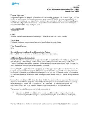
B9 # 22-1945 Water &Wastewater Commission: May 11, 2022 Council: June 9, 2022 Posting Language ..Title Recommend approval to negotiate and execute a cost participation agreement with Gateway Oasis V LLC for the City to reimburse the developer for an amount not to exceed $9,766,500 for costs associated with the design and construction of an oversized water main and appurtenances related to Service Extension Request No. 4989 that will provide water service to a proposed manufactured home and recreational vehicle (RV) development located at 10203 Rodriguez Road. ..De Lead Department Austin Water. Client Assistant Director of Environmental, Planning & Development Services, Kevin Critendon. Fiscal Note Funding is contingent upon available funding in future budgets of Austin Water. Prior Council Action: N/A. Council Committee, Boards and Commission Action: May 11, 2022 – To be reviewed by the Water and Wastewater Commission. Additional Backup Information: The Dry Creek Ranch project consists of approximately 397 acres of land located at 10203 Rodriguez Road (the “Property”). The Property is located entirely within the City of Austin’s (the “City”) 2-mile Extra- Territorial Jurisdiction, Impact Fee Boundary, the Desired Development Zone, and the South Fork and Dry South Watersheds. A map of the property location is attached. Gateway Oasis V LLC (the “Owner”) is proposing to develop approximately 860 manufactured homes, 224 RV pads, and associated amenity spaces. The Owner requested that the City provide water utility service to the Property as proposed in Service Extension Request (SER) No. 4989. Wastewater service for each future lot within the Property is proposed by either utilizing an on-site sewage facility or a private package treatment plant. In accordance with Chapter 25-9 of the City Code, the City has asked the Owner to oversize the water main in order to serve additional properties within the South water pressure zone consistent with the City’s long range planning goals for this area. If approved by City Council, the City will cost participate in this construction project only to the extent of the City’s proportionate share of the oversized mains. The proposed oversized improvements include construction of: • approximately 24,100 feet of 36-inch water main from Thaxton Road and generally extending southeast along future East Slaughter Lane, southwest along FM 1625, and east to the Property. The City will reimburse the Owner for an overall total amount not to exceed $9,766,500 for hard costs and B9 # 22-1945 Water &Wastewater Commission: May 11, 2022 Council: June 9, 2022 soft costs. Hard costs include, but are not limited to, construction and materials. Soft costs include, but are not limited to, preliminary engineering reports, surveying, geotechnical studies, design, and project management. The City’s cost participation by project component is as follows: • For costs of the 36-inch water main (the minimum pipe diameter of 24-inches required to serve the Property to an oversized 36-inch) and appurtenances, the City’s maximum participation consists of: (1) hard costs, in an amount not to exceed 33% of the hard costs of the 36-inch water main and appurtenances, and (2) soft costs, in an amount not to exceed 15% of the City’s hard cost participation amount ` Other terms of the agreement will require that the Owner: • Pay all costs for financing, interest, fiscal security, accounting, insurance, inspections, permitting, easement acquisition, legal services, and other non-reimbursable soft costs associated with the project; • Conform to the City’s design criteria and construction standards, and environmental requirements; • Construct all improvements at their cost and, after the City’s final approval of the construction, dedicate the facilities to the City for ownership, operation, and maintenance; • Allow the City to use the project plans and specifications approved by the City to solicit and publish invitations for bids for the construction of the improvements; and • Follow the City’s standard bidding practices and procedures, including the minority-owned business enterprise procurement program found in Title 2 of the City Code, and Texas Local Government Code Chapters 212 and 252. The proposed project will be managed through Austin Water staff and is located in zip code 78747 and near Council District 2. Strategic Outcome(s): Government That Works for All. ..Strategic Outcome(s) J11 D N R O T X A H T B O K E E R K C E E E L R B C R E A M L B R A M D N R O T X A H T COTTONMOUTH CREEK LOCATION MAP Dry Creek Ranch Water SER-4989 L13 B S Y W H 3 8 1 S U S L G P WIN D R R VIE O O M D E E R C UFF S P RIN G S R D S P I R E V W LEROI DR E W I L L I A R K TE C F I N I A HILLO M C A N N O N D R L D R L A V A H IL L R D K14 K13 J14 Z E Q U IE L D R R D D L FIE G RIN D R H C N A R S E N A J P S D U N A R U B Y R A Y S T NT W A Y H T A P Y R T N E S D R T I O C N UTRIA R U N M A R B L E R I D G E D R TA R A D R J13 TH A XT O N R D ALUM ROCK DR D O Y Q UIN T O AL D N D R R M A R B L E C R E E K J12 E SLAUGHTER LN D R N E V A H R E T N W I O N BL C O LT L R E T D A L R K D UIL G O O R B HIL P K E E R H C T U K12 O M N O T T O C Q N A R T B E S T R I D E B N D A P O G E E B L V D S P I R E V W L O O K S E E S K Y TE L N X ST K11 L12 N O RT H F O R K D R Y C R E E K MC KENZIE RD L11 D 5 R 2 6 M 1 F S A S S M A N R D M13 FM 812 R D M12 M C K E NZIE R D M11 D 3 R 7 M 9 S F C I T A T I O N A V E D 3 R 7 M 9 S F M O O R E R D J10 T A ST NITA VIS N A L V A L K10 W E N D E R D L10 S O UTH VIE M10 W HILLS C V C O U L V E R R D K9 J9 R O D RIG U S HIV EL Y L N EZ R D N N L O S P SIM L9 LA M B E R T LN N R L E K C O L B M9 S U S 1 8 3 H W Y A CIR H A M T A C T T E S O O L D L O S O U T C K H A R T R D CIL R E C H F O J8 R K D GRID Subject Tract R Y Jurisdictions R C E K E Full Purpose City Limit Limited Purpose City Limit 2-Mile ETJ 5-Mile ETJ Creedmoor City Limit Creekmoor ETJ Mustang Ridge City Limit MILLER LN Mustang Ridge ETJ J7 W E V E L Y N R D MAHA CREEK C LIFF B R O O K D R K8 K7 S U N F L O W E R D R L8 M8 TIF F A N Y T R L V A LL EJ O P L AIN S L N O TILIA L N M A H A L O O R D P V O N Q UIN T U S R D S S H 130 SV R D N B S S H 130 S V R D S B S S H 130 N B M7 S S H 130 S B P L A H A D R O O M M A H A C R E E K L7 F M 1 3 2 7 R D REEK EVELYN RD M AHA C Feet 9,000 / 0 1,500 3,000 6,000 This product is for informational purposes and may not have been prepared for or be suitable for legal, engineering, or surveying purposes. It does not represent an on-the-ground survey and represents only the approximate relative location of property boundaries. This product has been produced by the City of Austin for the sole purpose of geographic reference. No warranty is made by the City of Austin regarding specific accuracy or completeness. 12/2/2021 ! ! ! ! ! ! ! ! ! ! V Y C A D N KIL D N A T O A B R N D 8" 4 5 6 0 " 8 660 680 0" 6 690 6 1 0 6 4 0 8" 4 8" 0 7 6 C O LT O N B LU FF S P RIN 8 " G S R D ! ! 5 8 0 T H A X T O N R D 6 6 0 5 6 0 6 " 8 4 5 9 0 0 0 E SLAUGHTER LN 590 12" S I L V E R T H O R N E S T !( 4 8 " 6 1 0 D N R O T X A H T 0 6 6 S K Y TE D V L X ST E B E G O P A 6 4 0 K11 J11 0 5 6 650 6 6 0 ! ! ! ! ! STAFF PROPOSED CONNECTION TO M 812 R EXISTING 36-INCH WATER TRANSMISSION MAIN F 5 3 0 540 540 0 5 5 0 5 5 D 6" 550 0 5 5 560 550 5 1 0 0 56 D 3 R 7 M 9 S F 0 2 5 5 6 0 6" 5 3 0 550 2" 560 D AIN R S R D M C A N G U " 8 8" N12 B F I N I A L D R K12 L12 3 6 " 0 0 6 61 0 E WILLIAM CANNON DR 1 2 " MC KENZIE RD 54 0 5 6 0 M12 530 510 " 6 24" 59 0 0 7 5 0 6 5 S U S 1 8 3 H W Y 0 2 5 0 4 5 0 5 2 0 2 5 0 8 5 M C K E N 6" ZIE R D 0 4 5 6" 6" 4 " 6" 6" M11 D 3 R 7 M 9 S F 5 8 0 24" 5 3 0 M10 6" 0 1 5 0 9 4 0 50 4 9 0 5 5 0 5 3 0 5 1 0 5 3 0 N11 5 0 0 S S H 5 3 0 S S H 1 3 0 1 3 0 S B S V R D 5 2 0 N B 0 1 5 STAFF PROPOSED APPROXIMATELY 24,100 FEET OF OVERSIZED 36-INCH WATER TRANSMISSION MAIN (SOUTH PRESSURE ZONE) M9 6 0 0 N9 580 0 8 5 54 0 630 " 6 ! ! ! ! ! ! ! ! ! ! ! ! ! ! ! ! ! ! ! ! ! ! ! ! ! ! ! ! ! ! ! ! ! ! ! 0 4 5 59 0 L11 5 9 0 5 9 0 0 57 S A S S M A N R D K10 W E N D E R D 580 L10 0 8 5 5 8 0 550 0 4 5 0 5 5 D 5 R 2 6 580 M 1 F 0 6 5 580 0 7 5 0 7 5 0 5 5 R O D RIG U E 0 4 6 Z R D N O L R E R R E U G 630 0 9 5 L9 6 3 0 A CIR H A M S U S 1 8 3 H W Y S B M V A LL EJ O P L AIN S L N 570 O TILIA L N L H A A O O P R D 55 0 TIF F A N O H Y T R L 6 3 0 L8 620 6 1 0 L7 0 62 6 2 0 0 3 6 6 4 0 F M 1 3 2 7 R D 630 M7 590 6 5 0 V E L Y 640 F M 1327 N R FM 1327 RD D K7 0 1,500 3,000 6,000 9,000 Feet W. S.E.R. Name: Dry Creek Ranch W. S.E.R. Number: 4989 Utility Development Services Plotted 10/28/2021 This product is for informational purposes and may not have been prepared for or be suitable for legal, engineering, or surveying purposes. It does not represent an on-the-ground survey and represents only the approximate relative location of the property boundaries. This product has been produced by the City of Austin for the sole purpose of geographic reference. No warranty is made by the City of Austin regarding specific accuracy or completeness. 0 5 5 8" 8" 6 " B 0 S 3 H 1 S S 0 56 580 8 " 8 " S S H 130 N B M8 8 " 8 " N8 5 7 0 0 5 5 O R I Z N N L 580 610 0 6 0 600 N7 0 7 5 Subject Tract 100-yr FEMA Floodplain Full Purpose City Limit 2-Mile ETJ Limited-Purpose City Limit Other City Limits Other ETJ 7 0 0 B O NIT 680 0 7 6 690 A S T A VIS T N A L V A L 0 4 6 J10 C O U L V E R R D 6 4 0 6 2 0 K9 6 3 0 J9 6 6 0 6 6 0 6 4 0 O LD L J8 O C K H A R K8 T R D 6 2 0 6 0 0 64 0 J7 W E 620 R D . C LIFF B R O 5 8 0 O K D R 570 6 1 0 0 3 6 DRAFT