B4. Location Map — original pdf
Backup
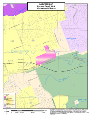
G43 K E E R Y C H S U R H B T U O S LOCATION MAP H43 Pearson Ranch West Wastewater SER-4499 H42 J42 O C O J43 N N O R D R R S D K A T O A E R G G42 A V E R Y R A N C H B L V D W P A R M E R L N G41 L A K E L I N E B L V D DAVIS SPRING BRANCH CREEK H41 N E E N A H A V E P E A R S O N R A N C H R D TURKEY HOLLOW J41 SPE CTRUM DR G40 R U T L E D G E S P U R H40 0 R D S B 5 W E B N F M 6 2 N S H 4 N FM 620 RD SB RAMP N F M 6 2 0 R D N SH 45 W SVRD WB N SH 45 W SVRD EB 5 W W B N F M 6 2 N S H 4 0 R D N B J40 A M B E R G L E N B L V D L A K E C R E E K G39 H39 J39 J38 ANDERSON MILL RD RATTAN CREEK Railroad GRID Subject Tract County Boundary Jurisdictions Full-Purpose City Limit Limited-Purpose City Limit Cedar Park Full-Purpose 2-Mile ETJ 5-Mile ETJ Cedar Park ETJ G38 S H A D Y O A K S D R / 0 H38 A N D E R S O N M I L L R D W P A R M E R L N 1,000 2,000 4,000 Feet 6,000 This product is for informational purposes and may not have been prepared for or be suitable for legal, engineering, or surveying purposes. It does not represent an on-the-ground survey and represents only the approximate relative location of property boundaries. This product has been produced by the City of Austin for the sole purpose of geographic reference. No warranty is made by the City of Austin regarding specific accuracy or completeness. 03/06/2020