B6 — original pdf
Backup
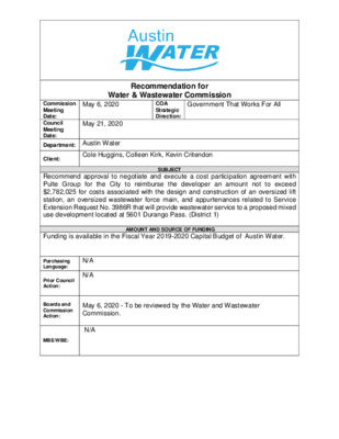
Recommendation for Water & Wastewater Commission Government That Works For All COA Strategic Direction: May 6, 2020 Commission Meeting Date: Council Meeting Date: Department: Austin Water May 21, 2020 Client: Cole Huggins, Colleen Kirk, Kevin Critendon SUBJECT Recommend approval to negotiate and execute a cost participation agreement with Pulte Group for the City to reimburse the developer an amount not to exceed $2,782,025 for costs associated with the design and construction of an oversized lift station, an oversized wastewater force main, and appurtenances related to Service Extension Request No. 3986R that will provide wastewater service to a proposed mixed use development located at 5601 Durango Pass. (District 1) Funding is available in the Fiscal Year 2019-2020 Capital Budget of Austin Water. AMOUNT AND SOURCE OF FUNDING N/A N/A Purchasing Language: Prior Council Action: Boards and Commission Action: MBE/WBE: May 6, 2020 - To be reviewed by the Water and Wastewater Commission. N/A The East Parke Subdivision – Phase 1 project consists of approximately 68 acres of land located at 5601 Durango Pass (the “Property”). The Property is located entirely within the City of Austin’s (the “City”) Full-Purpose Jurisdiction, Impact Fee Boundary, Austin Water’s service area for wastewater, the Desired Development Zone, and the Austin Creek Watershed. A map of the property location is attached. Pulte Group (“Owner”) is proposing to develop approximately 124 single-family homes, 300 multi-family units, and 110,200 sq. ft. of retail space. The Owner requested that the City provide wastewater utility service to the Property as proposed in Service Extension Request (SER) No. 3986R. Austin Water will provide retail water service to the Property. In accordance with Chapter 25-9 of the City Code, the City has asked the Owner to oversize the lift station and force main in order to serve additional properties within the Walnut Creek drainage basin consistent with the City’s long-range planning goals for this area. If approved by City Council, the City will cost participate in this construction project only to the extent of the City’s proportionate share of the oversized lift station and force main. The proposed oversized improvements include construction of an oversized lift station located near the southeast corner of the Property and approximately 2,020 feet of 10- inch force main from the proposed lift station, east along Loyola Lane to the existing 72-inch gravity interceptor. The City will reimburse the Owner for an overall total amount not to exceed $2,782,025 for Phase 1 hard costs and soft costs. Hard costs include, but are not limited to, construction and materials. Soft costs include, but are not limited to, preliminary engineering reports, surveying, geotechnical studies, design, and project management. The City’s cost participation by project component is as follows: • For costs of the Phase 1 oversized lift station and force main (the minimum pumping capacity of 288 GPM required to serve the Property to an oversized pumping capacity of 1,600 GPM) and appurtenances, the City’s maximum participation consists of: (1) hard costs, in an amount not to exceed 82% of the hard costs of the lift station and force main and appurtenances, and (2) soft costs, in an amount not to exceed 15% of the City’s hard cost participation amount. To serve the Property, the Owner will additionally be required to construct, at their own cost: • approximately 630 feet of 12-inch gravity wastewater main from the existing 8- inch gravity wastewater main in Loyola Lane, west along Loyola Lane to the proposed lift station; • approximately 155 feet of 8-inch gravity wastewater main from the existing 8- gravity wastewater main located at the intersection of Coolbrook Drive and Millrace Drive, west along Coolbrook Drive to the Property. Other terms of the agreement will require that the Owner: • Pay all costs for financing, interest, fiscal security, accounting, insurance, inspections, permitting, easement acquisition, legal services, and other non- reimbursable soft costs associated with the project; • Conform to the City’s design criteria and construction standards; • Construct all improvements at their cost and, after the City’s final approval of the construction, dedicate the facilities to the City for ownership, operation, and maintenance; • Allow the City to use the project plans and specifications approved by the City to solicit and publish invitations for bids for the construction of the improvements; and • Follow the City’s standard bidding practices and procedures, including the minority-owned business enterprise procurement program found in Title 2 of the City Code, and Texas Local Government Code Chapters 212 and 252. The proposed project will be managed through Austin Water staff and is located in zip code 78724, in City Council District 1. M27 E D B E D B L U E X C H A N G E D R R I D G E P O I N T D R E 2 9 0 W B T O A N D E R S O N W B R A M P L U E S T E S T E I N B EI N B L V L V D S D S V R V R D N B D S B C H R A G E I G H T O N L N R E T N N E E V L A D L D R R R L D E X E R D M26 R O A N O K E D R R N D R U B U A B U R N E L L D R V A S S A R D R N E L U Q U B U D V A C P M A T L Y N V A RID G L D R E D R R O C K H U R S T L N T S P N O RTH E A LAKESIDE DR G K I N ST D R J A C K C O O K D R M A N O R R D H Y S I D E D R D E R L A D G RIN P S R D D N A L H S A G R E E N S B O R O D R R ZIA D L I T T L E W D N B Y L E K A L B A L N U T C R E E K B N D V L B N I E T S E U L B D E M25 R E XF R O G G E L N O R D D R R N D O T T I P N D L O O W S S A B N Y L R A N A N C E D L O G M24 D E R L A D G RIN P S W A L D E N C I Basemap Polygon R Street Names Railroad GRID R L D HIL R L D Y D HIL R N L D U N B O HIL S R D A A C O R B Austin Impact Fee Boundary E MA R T IN L U T H E R K IN G JR B L V D Subject Tract Jurisdictions E 51ST ST R N D O S A J L R R T E W O T N R L E G E U R K R E D L A N L L D T S HIL A E E N N A T Full-Purpose City Limit H E 2-Mile ETJ F 5-Mile ETJ LIN L LIMITED PURPOSE N / 0 M23 900 1,800 3,600 R Y D C N E G E R FM 969 RD B S D V L B N I E T S E U L B D E LOCATION MAP East Parke Subdivision - Phase 1 E US 2 90 HWY SVRD WB Wastewater SER-3986R E U S 2 90 HW Y S V R D E B E U S 2 90 H W Y W B E U S 2 90 H W Y E B K A R L I N G D R P27 O L D M A N O R R D F E R G U S O N C T O F K E E R C T U N L A W N27 A N DT R E D U K E BLV D E R D D E R L A D G RIN P S C R A I N W A Y D R S S A S P O HIS C N26 L A Z Y C R E E K D R R I O P A S S B U R G P E C A N B U N D R O O Y D R P U R P MARS LN K D G A L R E S R N D R S K D S TIO A N P O A O PIR R O B NIS L S A IN N T U S G Y E D R R C E D C A R L MIL COOLBROOK DR R N25 L O Y O LA LN D RIS R R O Y M N N H O J N24 W A L N U T C R E E K P26 S T A R C R E S T L N P O I N T N O R T H D R M U F F I N D R R Y D R E D R A H L C Y O A Z B P25 R L D WIL R A C R T D R N D F O R O C N L N HIL A H S R I T C H I E S I E D P R E L D R A R F D RIE O N H O L S D G N A VIR S S L N P24 R E P S I G N A L P T R LITA D R E D L VIL E S N E R O L F N CIA L E V A A T R S N A E C PIZ S O T T A D R P I N O N V I S A C I R H T A G A L R R T E R TIN D D O O W L E M R Y D O TIC A S T A P T O P A T O N G N O P O L N A L N A L N N23 AVA LN W R O G E R S L N P23 Feet 5,400 This product is for informational purposes and may not have been prepared for or be suitable for legal, engineering, or surveying purposes. It does not represent an on-the-ground survey and represents only the approximate relative location of property boundaries. This product has been produced by the City of Austin for the sole purpose of geographic reference. No warranty is made by the City of Austin regarding specific accuracy or completeness. 4/4/2020 !P % % 8" C O N C % % !P !P RATON PASS %% % 8 " C O % N C R K D E % E !P R % Y C Z A L % 8" C % O N C 0 1 5 5 6 0 E D B L U E 5 6 0 560 E D B L U E S T E I N B L V D S N26 V R D S B E D E D S T E I N B L U E S T E B L V D N B I N B L U E S T E I N 5 5 0 B L V D S B B L V D S V R D N B 5 4 0 0 6 5 5 5 0 5 5 0 0 6 5 5 7 0 G R E % E N S B O R % O !P D R HIG H P % C N O 8" C !P OIN % T D R % !P % !P % % !P !P !% !P % 0 9 4 % S C S N A N P O 8" C O NIS % N U G % N C % !P % 8" C O % N C N % O R 8" C D D E E W % % !P E L B M C U T N % O 8" C % !P 8" C ! ! ! ! ! ! ! ! ! ! !P % R % !P N D C V TIO C 8" P N 510 % A O % PIR 8" C !P % S IN C !P V 8" P 8" C % % !P !P 8" C 8" P N C !! % % !! !% % O O V ! ! ! ! ! ! ! ! % % ! C O % !P % !P !P % S S P M U % % !P A P % S A B 8" A % % !P S B 8" A % !P C % 8" C O P U N C R P L !P E S % % A G 0 0 5 % ! !P 8" P ! !! D U 8" C E D R % O N C % % ! ! ! ! ! ! ! ! ! ! ! ! ! ! ! ! !! ! ! % % C % % SS !P !P !P !P % !P N % ! % ! M A ! R % % ! ! R % A !! V N C % % !P !P !! G O P !! % ! A !P N % !! % N L !! E R U % N B S LN !P !P % A !%! V !P % !P % PHASE 2 - STAFF PROPOSED % !P % APPROXIMATELY 2,990 FEET OF !P !P % % OVERSIZED 15-INCH GRAVITY % Y A % WASTEWATER MAIN W !P N % O ! T S ! !P % W E L C !P ELL CT % V 8" P !P % Y CIR % !P E L L A % K V K VALLEY D O O !P R % R B % R E D C A R % L B R MIL O % !P !P CASCO WALK !P !% % !P !P !% !P % R D K O O R B L A T S Y R C !P % % % % !P % % !P % % !% O ! ! ! I ! ! !! !! ! ! ! ! ! ! ! ! ! ! ! ! ! ! ! ! ! ! ! % % % % PHASE 1 - STAFF PROPOSED APPROXIMATELY 155 FEET % % OF 8-INCH GRAVITY WASTEWATER MAIN % %% !P WHITEBROOK DR BOULDER CREEK SILVERBROOK LOOP 8" CONC % %% !P !P !P % !P % 8" CONC !P % % !P % !P % !P % % % % !P % % 4 8 ! 0 C % N O C !P %% " 8 8" CONC % HALLO !P % ! W ! ! 8" PVC ! ! !P % ! ! % ! !! !P 8" PVC % !! !! !! ! ! ! C V 8" P ALK % !P TH W % C V 8" P R O W % ELLS !P !% !P !! % ! ! ! ! ! ! !! !! % 8" PVC !! !! 470 0 8 4 0 7 4 !P % !P % COOLBROOK DR % PHASE 1 - STAFF PROPOSED % APPROXIMATELY 615 FEET OF % !P 12-INCH GRAVITY WASTEWATER MAIN !P % % % !P %% % % % % !P % % % !P % PHASE 1 - STAFF PROPOSED APPROXIMATELY 2,350 FEET OF 10-INCH FORCE MAIN % % Subject Tract 100-yr FEMA Floodplain City of Austin Parks !P !P !P 5 3 0 0 2 5 0 1 5 N25 8" P % V C % !P % !P % 8 " 8 ! % " ! ! % !P P % ! ! ! ! C V P V C !P C O R I N N A R D !P !P % % !P % ! ! ! % !P !P !( LOYOLA LN ! ! ! !P !% D N PHASE 1 - STAFF B % ! Y L E PROPOSED 1,600 GPM LENA DR K A L PUBLIC LIFT STATION B % !P % L A D Y C T !P !% ! ! ! ! ! ! ! PHASE 1 - EXISTING 10-INCH !P !P %!% !% GRAVITY WASTEWATER MAIN TO BE ABANDONED % % % !P % DD DD C A % DD " 0 1 DD % !P C 0" A 1 % !P % !P %% D " !P % 8 I 1 2 " A C % !P . 0 250 500 1,000 1,500 Feet W.W. S.E.R. Name: East Parke Subdivision (Revised) W.W. S.E.R. Number: 3986R Utility Development Services Plotted 4/8/2020 This product is for informational purposes and may not have been prepared for or be suitable for legal, engineering, or surveying purposes. It does not represent an on-the-ground survey and represents only the approximate relative location of the property boundaries. This product has been produced by the City of Austin for the sole purpose of geographic reference. No warranty is made by the City of Austin regarding specific accuracy or completeness. DRAFT