B9 — original pdf
Backup
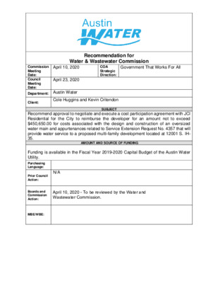
Recommendation for Water & Wastewater Commission Government That Works For All COA Strategic Direction: April 10, 2020 Commission Meeting Date: Council Meeting Date: Department: Austin Water April 23, 2020 Client: Cole Huggins and Kevin Critendon SUBJECT Recommend approval to negotiate and execute a cost participation agreement with JCI Residential for the City to reimburse the developer for an amount not to exceed $450,650.00 for costs associated with the design and construction of an oversized water main and appurtenances related to Service Extension Request No. 4357 that will provide water service to a proposed multi-family development located at 12001 S. IH- 35. AMOUNT AND SOURCE OF FUNDING Funding is available in the Fiscal Year 2019-2020 Capital Budget of the Austin Water Utility. Purchasing Language: N/A Prior Council Action: MBE/WBE: Boards and Commission Action: April 10, 2020 - To be reviewed by the Water and Wastewater Commission. The 12001 S. IH-35 project consists of approximately 58 acres of land (the “Property”). The Property is located entirely within the City of Austin’s (the “City”) Full-Purpose Jurisdiction, Impact Fee Boundary, Austin Water’s service area for water, the Desired Development Zone, and the Onion Creek Watershed. A map of the property location is attached. JCI Residential (the “Owner”) is proposing to develop approximately 900 multi-family units. The Owner requested that the City provide water utility service to the Property as proposed in Service Extension Request (SER) No. 4357. Austin Water will provide retail wastewater service to the Property. In accordance with Chapter 25-9 of the City Code, the City has asked the Owner to oversize the water main in order to serve additional properties within the South water pressure zone consistent with the City’s long range planning goals for this area. If approved by City Council, the City will cost participate in this construction project only to the extent of the City’s proportionate share of the oversized main. The proposed oversized improvements include construction of approximately 5,400 feet of 16-inch water main from the existing 36-inch water transmission main located north of the Property, south along the IH-35 frontage road to the existing 16-inch water main located south of the Property. The City will reimburse the Owner for an overall total amount not to exceed $450,650.00 for hard costs and soft costs. Hard costs include, but are not limited to, construction and materials. Soft costs include, but are not limited to, preliminary engineering reports, surveying, geotechnical studies, design, and project management. The City’s cost participation by project component is as follows: • For costs of the 16-inch water main (the minimum pipe diameter of 12-inches required to serve the Property to an oversized 16-inch) and appurtenances, the City’s maximum participation consists of: (1) hard costs, in an amount not to exceed 25% of the hard costs of the 16-inch water main and appurtenances, and (2) soft costs, in an amount not to exceed 15% of the City’s hard cost participation amount. Other terms of the agreement will require that the Owner: • Pay all costs for financing, interest, fiscal security, accounting, insurance, inspections, permitting, easement acquisition, legal services, and other non- reimbursable soft costs associated with the project; • Conform to the City’s design criteria and construction standards; • Construct all improvements at their cost and, after the City’s final approval of the construction, dedicate the facilities to the City for ownership, operation, and maintenance; • Allow the City to use the project plans and specifications approved by the City to solicit and publish invitations for bids for the construction of the improvements; and • Follow the City’s standard bidding practices and procedures, including the minority-owned business enterprise procurement program found in Title 2 of the City Code, and Texas Local Government Code Chapters 212 and 252. The proposed project will be managed through Austin Water staff and is located in zip code 78747, in City Council District 5. R D K O O R B H S A R H D N Y L S N A O R M N U O T C U A LOCATION MAP 12001 S. IH-35 Water SER-4357 E F M 1626 R D P M A R B S 5 3 H I O T B E 6 2 6 1 M F E R D Y N O L O C N W O R C D NIO R O T N N A A D S L O N H L A R R A F O N I O N C R E E K F11 ONION CREEK PKWY L E G E N D S L N O N I O N C R E E K G11 R S T D R U H E S PIN PIN E H U R ST D R P M A K R B D S R E E V R 5 S N C S IH 3 NIO O O B T 5 N S IH 3 EVE LN G10 T C E T N A M G A X I N R O M A Z F10 T O L U C A D R ALLEN DE B N D R O D R E D A M T A S A M I R T L A Y W K CIA P O L D S A N A N T O N O R Railroad D GRID AVENIDA MERCADO ST Austin Impact Fee Boundary N A T S E Basemap Polygon Street Names I Subject Tract Jurisdictions Full-Purpose City Limit 2-Mile ETJ 5-Mile ETJ LIMITED PURPOSE PURYEAR RD West Lake Hills Full-Purpose Jurisdiction West Lake Hills ETJ / 0 B D N R V 5 S S IH 3 B 5 S S IH 3 P M A B R N 5 S 3 O B T B E W 5 N S IH 3 H 4 S S 5 G9 W R D B R A D S H A F9 S SH 45 E WB S SH 45 E EB FM 1327 RD 600 1,200 2,400 Feet 3,600 This product is for informational purposes and may not have been prepared for or be suitable for legal, engineering, or surveying purposes. It does not represent an on-the-ground survey and represents only the approximate relative location of property boundaries. This product has been produced by the City of Austin for the sole purpose of geographic reference. No warranty is made by the City of Austin regarding specific accuracy or completeness. 3/12/2020 ! ·. ·. È( N ·. H L ·. A R È( ·. ·. R A F ·. ·. ·( ·. ·. ! ! ! ! ! ! ! ! ! ! ! ! ! ! ! ·. È( ·. È( ·. È( ·. ·( ·. ·. ·. ·. ·. ·. ·. ·. ·. ·. ! . · ! ! ! ! ! ! ! ! ! ! ! ! ·. ·. ·. ·. !! R R Y B N S O È( ·. ·. L ·. 5 ·. ·( ·.·. ·. ·. O 3 N C H È( ·. ·. ·. I È( ·. È( È( ·. ·. È( ·. O ·. ·. ·. W ·. ·. ·. T È( O ·. B È( R ONION CREEK PKWY È( È( E O C ·( È( ·. ·. ·. ·. ·. 6 ·. ·. " 2 2 ·. B T ·. È( È( 6 1 ·. ·. ·. ·. 1 ·. ·( È( ·. 5 N ·. ·. M ·. ·. ·. ·. 0 F !!!! È( S 3 2 E 6 È( È( ·. ·. È( È( ·. ·. ·( ·. ·. ·. ! ! ! ! ! ! ·. ·. ·. ·. ·. ·. ·. !! ! · . . · ! ! . · ! ! ! ·. È( ·. ·. È( ·. ·. È( È( È( ·. ·. ·. ·. ·. ·. ·. ·. È( ·. ANACUA LOOP · . · · ·( . · . . ·( ·. ·. ·. ·. ·. ·. ·. ·. ·( ·( ·. ·. ·. ·. ·. ·. 600 D ·. ·. ·. ·. ·. ·. ·( NIO R ·( ·. ·. ·( ·. ·. ·. ·. ·. ·. ·( ·. 0 6 0 5 9 0 È( L E G ·. E N D S L N 620 È( R D Y N O L O " C 6 N W ·. O R C ·. " 8 " " I L 8 E P B B B ·. E 4" " 2 1 P R A P P L E V A L L E Y C I R E ·. S T O T C O R A L R I D G E C I R N ·. ·. È( ·. T R A È( ·. ·. " È( ·. PRESTON TRAILS CV 4 INVERRARY CIR È( C ·. S ·. 8" ·. ·. E L ·. B A " G 4 L A R O C T D C R R È( A ·. ·. E L C T N I O P O N O N ·. C R E E K A ·. C 8 " L S H R D E 6 I · . 5 6 0 0 8 5 S P I N E . · S T D R U H · . ·. È( ·. ·. È( R D T E K C ·. R C N O 6" R E M S D È( L L E I I R R È( ·. ·. MERION CRICKET CT IN ·. South Reduced (SO4) U R H ·. E C T PIN ST D È( OPTION 2 - STAFF PROPOSED APPROXIMATELY 425 FEET OF OVERSIZED 16-INCH WATER MAIN T O N H E A T H C I R È( ·. È( ·. ·. ·. OPTION 1 - STAFF PROPOSED APPROXIMATELY 900 FEET OF OVERSIZED 16-INCH WATER MAIN ·. È( W A L 8" 590 È( DIA 58 N ·. 0 R W 0 5 7 6 0 0 0 1 6 O T N N A A D S OL 590 5 8 0 6 1 0 5 8 0 T A P M E R R I T O P I C G O A X I N C V R O S S M T A Z 6 2 0 620 580 600 ·. " 6 3 ·. ·. ·. È( ·. ·. È( ·. ·. ·. ·. ·. 6 3 0 7 1 0 P M A K R " 6 3 P M A R B S 5 E 3 E H R I N C O T NIO K E E O O R B C B T 5 N N O 5 N S IH 3 I N O S IH 3 6 5 ·. ·. È( 0 6 6 0 60 0 0 1 7 " 6 3 ·. È( ·. P E ·. S T È( ·. ·. A È( ·. N ·. CIA P 8" ALLE È( DE B ·. ·. LIN I . · ! ! ! ! ! ! ! ! ! ! ! ! ! ! ! !! ! ! ! ! !!! · . · . 1 7 0 ! ! . · T ·. P S ! ! A N A C R R U A N E L W O O E T Y R A D N N ·. ·. 8 ·. ·. ·. ·. ·. ·. ·. ·. ·. ·. ·. ·. E ! ·. ·. K ! ! !! ! ! ! ! ! ! ! ! B ·. N D ·. ! ! ! ! ! A L ·. L ·. E N D E " 6 3 È( ·. ·. ·. ·. ·. È( ·. È( ·. 8" È( R T È( A V È( O D È( ·. ·. ·. ·. A ·. ·. " L ·. È( È( R ·. · ·. E È( . È( ·. T T R ·. D A L E ·. A S O D S LN ·. È( ·. A 8" È( È( ·. M K È( !! ! ! ·. ! È( MIR ! È( ·. ·. W R ! ! ·. ·. ! ·. ·. È( È( Y CARDENAS LN ·. ! E ! ·. ·. ! !! È( Y È( ! ·. ·. ·. È( W ·. D ! È( A ·. B ·. ·. ! ·. È( È( A K T ! ·. 5 S M L ·. ·. ·. È( CIA P ! ! ! ·. A ·. ! ·. È( " È( È( Y ! S IH 3 È( ·. ·. ·. 8 ! ·. ·. A !! ·. È( !!!! ·. CAMINO VAQUERO PKWY ·. ·. ·. B LIA W T ·. ·. ·. ·. N A S D N È( ·. R A È( R M I R ·( ·. ·. ·. T È( ·. È( ·. ·. R S ·. ·. ·. N D ·. ·. È( E È( ·. ·. ·. ·. E ·. V ·( ·. ·. ·. R ·. ·. 5 S O 8 " ·. È( M S IH 3 . ·. · ·( ·. ·. ·. È( ·. ·. ·. ·( ·. È( ·. ·( ·( ·. ·. ·( È( . · ·. ·( ·( È( ·. ·( È( È( ·. ·. ·. ·. ·. ·( ·. ·. ·. ·. ·. ·. ·. ·. È( ·. ·. ·. È( P ·. M ·. ·. ·. A ·. 7 R È( ·. È( È( ·. ·. ·. ·. ·. ·. South R G H D È( " 2 4 0 6 7 6 8 0 ·. ·. ·. ·. ·. ·. ·. ·. W R ·. ·. ·. ·. C A K N A · . Y P S E B U R T S · . I T L T ! . . · · A A P I T 2 3 P M P 42" A M ·. R A ·. B R B N 5 N 5 3 3 H 0 I S O 3 O 7 T B T 7 2 3 W " 1 2 5 E 4 H 4 ·. S S È( ·. " 2 4 7 2 0 O 1 B T B D S 5 S R S IH 3 V 5 S S IH 3 0 4 7 7 4 0 7 5 0 . W. S.E.R. Name: 12001 S IH 35 W. S.E.R. Number: 4357 Utility Development Services Plotted 03/28/2019 0 2 7 6 8 0 640 660 670 710 700 7 3 0 7 0 0 690 0 500 1,000 2,000 3,000 Feet 680 6 6 0 670 6 9 0 650 670 6 9 0 680 0 7 6 0 6 6 Subject Tract 100-yr FEMA Floodplain Full-Purpose City Limit 2-Mile ETJ Limited-Purpose City Limit 7 0 5 7 4 0 OPTIONS 1 & 2 - STAFF PROPOSED APPROXIMATELY 4,450 FEET OF OVERSIZED 16-INCH WATER MAIN 710 This product is for informational purposes and may not have been prepared for or be suitable for legal, engineering, or surveying purposes. It does not represent an on-the-ground survey and represents only the approximate relative location of the property boundaries. This product has been produced by the City of Austin for the sole purpose of geographic reference. No warranty is made by the City of Austin regarding specific accuracy or completeness.