B15 — original pdf
Backup
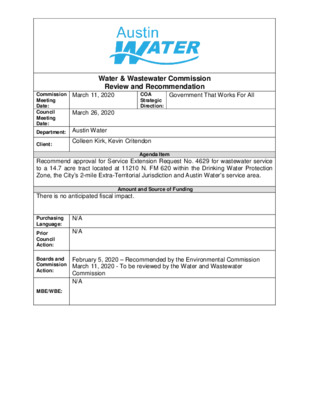
Water & Wastewater Commission Review and Recommendation Government That Works For All COA Strategic Direction: March 11, 2020 Commission Meeting Date: Council Meeting Date: Department: Austin Water March 26, 2020 Client: Colleen Kirk, Kevin Critendon Agenda Item Recommend approval for Service Extension Request No. 4629 for wastewater service to a 14.7 acre tract located at 11210 N. FM 620 within the Drinking Water Protection Zone, the City’s 2-mile Extra-Territorial Jurisdiction and Austin Water’s service area. Amount and Source of Funding There is no anticipated fiscal impact. N/A N/A Purchasing Language: Prior Council Action: Boards and Commission Action: MBE/WBE: February 5, 2020 – Recommended by the Environmental Commission March 11, 2020 - To be reviewed by the Water and Wastewater Commission N/A The Aspen Heights Multifamily project consists of approximately 14.7 acres of land located at 11210 N. FM 620 (the “Property”). The Property is located entirely within the City of Austin’s (the “City”) 2-mile Extra-Territorial Jurisdiction, Impact Fee Boundary, Austin Water’s service area for wastewater, the Drinking Water Protection Zone, and the Lake Travis and Bull Creek Watersheds. A map of the property location is attached. Applicant: Adrienne Choi and Yong B. Choi (the “Owners”) are proposing to develop approximately 215 multi-family units and 5,300 sq. ft. of associated leasing office/amenity center. The Owners requested that the City provide wastewater utility service to the Property as proposed in Service Extension Request (SER) No. 4629. Austin Water will provide retail water service to the Property. City Code § 25-9-35 requires City Council approval for this SER because the Property is located within the Drinking Water Protection Zone and outside the City’s full-purpose corporate limits. The City will not cost participate on this project. Infrastructure Improvements: To serve the Property, the Owners will be required to construct: • approximately 125 feet of 8-inch gravity wastewater main from the existing 8-inch gravity wastewater main located on the east side of N. FM 620 to the Property, • an appropriately sized upgrade to the existing Volente Lift Station The proposed wastewater improvements are sized to serve the needs of the Property and will conform to all City Code requirements. These improvements will be designed in accordance with City’s Environmental Criteria Manual and Utilities Criteria Manual and will be inspected by the City’s Development Services Department. The Owners will construct all required improvements at their cost and dedicate the facilities to the City for ownership, operation and maintenance. All City fees are applicable to the provision of wastewater service including capital recovery fees. City Staff Recommendation: Austin Water has evaluated the Owners’ request for City wastewater service and can provide centralized wastewater service as proposed in SER-4629. Attached is a report provided by finds no significant environmental concerns with providing centralized wastewater service as proposed in SER-4629. Contingent upon approval of SER-4629 for wastewater service to the Property, approval of any related development applications for the Property is subject to current City Code. In summary, City staff recommends the approval of SER-4629. The proposed project is located in zip code 78726 and is near City Council District 6. the Watershed Protection Department that R E T Y D N I W 954 9 3 0 946 982 2 7 9 970 974 9 7 4 966 962 9 9 6 9 8 4 ANDERSON MILL RD 2 3 9 9 3 6 9 3 8 978 9 6 4 958 9 6 6 948 986 9 8 6 9 9 4 1 0 3 2 6 2 0 1 1028 0 2 0 1 1022 2 1 0 1 0 2 0 1 8 2 0 1 1032 1 0 3 4 1 0 3 6 1 0 3 4 1034 1034 1 0 3 4 1032 1034 1026 1 0 3 0 1030 1028 2 3 0 1 2 3 0 1 STAFF PROPOSED UPGRADE TO VOLENTE LIFT STATION 960 9 7 6 9 6 8 0 8 9 982 E38 988 992 9 9 0 99 8 1 0 0 0 1 0 0 2 1 0 1 4 1 0 1 4 1 0 1 6 1018 1 0 2 0 1 0 1 4 1018 1 0 1 6 \ \ % \ 2 \\\ " P \ V \ % C \ \\ \ % % !P % !P$. % \\ 2" P V C \ !P !P % % 1032 1030 1 0 2 6 % 8" PVC !P !P % % % %% !P 1034 8" P 8" PV C % N F M 620 R D 4" DI \ \ \ \ \ !P % V C % %% !P !P % !P \ \ \ % \ \ % 1024 1024 10 24 1022 1020 4 2 0 1 % !P % !P % \ \ \ \ \ \ \ % \ \\ 1 0 1 8 % !P \ \ $. %% !P \ \ \ % 8" P V C % % !P 8" P V C ! ! % $. !P !P ! !! !!% % !P % % 1 0 0 0 \\ \ % % !P \ \ VOLENTE LS "J[7L \ !P % !P 994 \ % \ 1 0 0 8 9 9 6 1 0 0 2 99 4 9 8 4 980 2 1 0 1 1 0 0 6 1014 1 0 1 4 !P !P !% % ! ! ! ! ! ! ! ! 8 0 0 1 ! ! % ! ! ! ! ! 6 0 0 1 6 0 0 1 !P % ! ! ! ! ! ! ! C V % " P 8 ! 9 8 6 9 9 4 9 9 2 A L O E V E R % 1 0 1 6 E L S 1 0 2 0 A LID O P K W 4 2 0 1 !P % % !P ALO E VE R A TRL !P % Y % !P 1012 % % !P 1018 % 8" P V C 1 0 1 8 % !P 10 24 8" PV C % 1030 1030 % !P % 8" P V C V % !P C % !P 8 " P 28 10 C % V P " 8 % !P 1 0 L R T R A R B E SHOW BARN CV L G N A T !P % !P % 2 6 I O M S O N C WILLIA T R A VIS C 1022 O U N U N TY T Y % 8 % " P V C % % !P 1 0 1 8 1 0 1 6 % 9 9 8 N L R E L T N A 1 0 1 4 0 1 0 1 !P ! % !! ! ! !P % % C V " P 8 !P !% !! FO 0 1 0 1 8 8 9 UNDATIO 4 0 0 1 N RD STAFF PROPOSED APPROXIMATELY 125 FEET OF 8-INCH GRAVITY WASTEWATER MAIN 9 7 8 N R L E L T N A 4 0 0 1 9 9 0 4 8 9 9 7 4 2 7 9 966 9 6 8 2 6 9 TU R TLE LN 982 9 7 6 960 9 4 4 9 3 4 9 4 2 9 5 6 950 952 940 0 6 9 946 9 3 4 9 2 0 926 9 3 0 918 922 8 3 9 9 6 2 % 958 954 0 7 9 958 9 9 2 3 4 9 6 4 8 916 932 % !P % C !P % V L A P !P % U " R 8 E L C R E % E K 9 2 8 !P!P !P %% R C I % % 1 0 0 0 1 0 0 8 0 1 0 1 1 0 1 2 1 0 1 2 2 1 0 1 4 1 0 1 0 250 500 1,000 1,500 Feet W.W. S.E.R. Name: Aspen Heights Multifamily W.W. S.E.R. Number: 4629 Utility Development Services Plotted 02/06/2020 Subject Tract Full-Purpose City Limit 2-Mile ETJ Limited-Purpose City Limit Cedar Park City Limits Cedar Park ETJ This product is for informational purposes and may not have been prepared for or be suitable for legal, engineering, or surveying purposes. It does not represent an on-the-ground survey and represents only the approximate relative location of the property boundaries. This product has been produced by the City of Austin for the sole purpose of geographic reference. No warranty is made by the City of Austin regarding specific accuracy or completeness. W IN D Y RID G E R D D38 1 0 0 4 992 9 8 8 9 9 2 994 9 8 0 9 8 4 6 9 9 972 8 7 9 2 8 9 E37 9 9 8 9 9 4 D37 0 9 9 6 8 9 . DRAFT MEMORANDUM January 27, 2020 Kaela Champlin, Environmental Officer’s Office Linda Guerrero, Chair, and Members of the Environmental Commission TO: FROM: DATE: SUBJECT: Aspen Heights Multifamily Wastewater Service Extension Request #4629 Service Extension Requests (SER) located in the Drinking Water Protection Zone and outside of the City of Austin’s full purpose jurisdiction require Council approval and review by the Environmental Commission. Watershed Protection Department staff has completed the review for Aspen Heights Multifamily Wastewater SER #4629 and recommend approval of the request. Site Overview The site consists of one tract of approximately 14.70 acres, located at 11210 FM 620 Road in the City of Austin’s 2-mile extraterritorial jurisdiction. The site is in the City of Austin’s Limited Purpose Jurisdiction The site is currently operating as a driving range without water or wastewater service. The applicant is proposing to develop a multifamily development with three four-story buildings with a total of 215 units, with associated leasing and amenity centers. Development Impacts Water: City water will be provided to the site, but a water SER is not required because water is in the front of the property along FM 620. Wastewater: The Applicant shall construct approximately 125 feet of appropriately sized gravity wastewater main from the existing 8-inch gravity wastewater main (Project No. 2015-0850) on the east side of N FM 620 and extend west across N FM 620 Rd to the subject tract, as approximately shown on the attached map. The applicant shall also construct an appropriately sized upgrade to the existing Volente Lift Station (approximately 220 gpm firm capacity). Upgrades shall include, but are not limited to, replacement of existing pumps, generator, and starters. 2 Environmental Impacts The property is split between the Lake Travis watershed, classified as Water Supply Rural, and the Bull Creek watershed, classified as Water Supply Suburban. The site is in the Drinking Water Protection Zone, and the Edwards Aquifer Recharge Zone, and drains to occupied Jollyville Plateau Salamander habitat. An Environmental Resource Inventory was conducted by the applicant, and no known recharge critical environmental features or critical environmental features were found onsite. Recommendation Staff recommends approval of Wastewater SER #4629. Staff review determined that there are no significant environmental risks to extend service to the site. The proposed project is consistent with Austin Water’s business plan and located within the Council-approved impact fee boundary. Additionally, previous SERs have been approved by Council within a one-mile radius of the site. cc: Kevin Critendon, P.E., Austin Water Colleen Kirk, P.E., Austin Water Katie Frazier, P.E., Austin Water Chris Herrington, P.E., Watershed Protection Department 3 City of Austin | Austin Water P.O. Box 1088 Austin, TX 78767 AustinWater.org MEMORANDUM To: From: Date: Subject: Aspen Heights Multifamily (Wastewater SER-4629) Water and Wastewater Commissioners Colleen Kirk, P.E., Utility Development Services February 6, 2020 Enclosed is additional technical information related to Wastewater SER-4629, and the associated Request for Council Action. Other SERs: There are 21 water SERs located within one-half of a mile of the subject tract. Of these SERs, 5 were administratively approved, 11 were approved by City Council, and 5 were withdrawn prior to City Council consideration. None of these SERs were denied by City Council. There are 17 wastewater SERs located within one-half of a mile of the subject tract. Of these SERs, 5 were administratively approved, 8 were approved by City Council, and 3 were withdrawn prior to City Council consideration. One of these SERs is currently under review by Staff. None of these SERs were denied by City Council. Water Utility Service: The City’s existing water distribution system is located in N FM 620 Road at the subject tract. A water SER is not applicable due to the availability of water service at the subject tract. Wastewater Utility Service: The City’s existing wastewater collection system is located along the east side of N FM 620 Road, approximately 125 feet from the subject tract. SER Improvements: The SER improvements will not cross known environmental features. The SER improvements will conform to all City Code requirements, be designed in accordance with the City’s Environmental Criteria Manual and Utilities Criteria Manual and be inspected by the City’s Development Services Department. If you need additional information, please let me know. Thank you. cc: Kevin Critendon, P.E., Assistant Director Greg Meszaros, Director The City of Austin is committed to compliance with the Americans with Disabilities Act (ADA). Reasonable modifications and equal access to communications will be provided upon request. LOCATION MAP Aspen Heights Multifamily Wastewater SER-4629 E39 MIM O SA PA SS PIN EY C R EEK LN PLU M C R EE K LN WILLIAMSON COUNTY E L S A LI D O P K W Y K E E R E C K A L D39 G E O S CIEN C E D R D38 R E T Y D N I W E38 N F M 620 R D A N D E R S O N M IL L R T A D N L R T Y R O L G G N N R O M I G L E B R I A R T R L T U R TLE L N H AR E TRL D N R TIO A D N U O F S W E E T B A BO SIL C T ULDER LN R LN LE T N A R T D E N O M L R L T NIA N E T N E C CONCHOS TRL R D D O O W K C E B C O N C H O S C V SLA N D D R C R O S A N D E N W O O D D R E R I C A L E I B R A D E L C V G H C T W IN D Y RID G E R D TRAVIS COUNTY ROLSTON PL HAN GIN G VALLEY D R D37 BUCKNER RD E37 N FM 620 R D Subject Tract Railroad GRID County Boundary Jurisdictions Full-Purpose City Limit 2-Mile ETJ 5-Mile ETJ Limited-Purpose City Limit Cedar Park City Limit Cedar Park ETJ / 0 500 1,000 2,000 Y A A W C O T A E M B Feet 3,000 E M R This product is for informational purposes and may not have been prepared for or be suitable for legal, engineering, or surveying purposes. It does not represent an on-the-ground survey and represents only the approximate relative location of property boundaries. This product has been produced by the City of Austin for the sole purpose of geographic reference. No warranty is made by the City of Austin regarding specific accuracy or completeness. 02/05/2020 G N D R E L