02 Presentation — original pdf
Backup
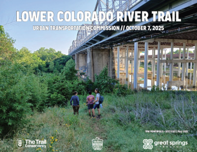
GUIDING LOCAL // REGIONAL PLANS LOWER COLORADO RIVER TRAIL LOWER COLORADO RIVER TRAIL URBAN TRANSPORTATION COMMISSION // OCTOBER 7, 2025 URBAN TRANSPORTATION COMMISSION // OCTOBER 7, 2025 TPW MONTOPOLIS + SITE VISIT | May 2025 TPW MONTOPOLIS + SITE VISIT | May 2025 THE COLLABORATIVE IDEA PROTECTING, ENHANCING, AND CONNECTING THE BUTLER HIKE-AND- BIKE TRAIL FOR THE BENEFIT OF ALL LOWER COLORADO RIVER TRAIL CREATING A 70-MILE NETWORK OF GREENWAYS IN EASTERN TRAVIS COUNTY AS A CRITICAL COMPONENT OF OUR REGIONAL TRAIL NETWORK CONSERVING LANDSCAPES + CONNECTING COMMUNITIES FROM THE ALAMO TO THE CAPITOL SOUTH WALNUT CREEK TRAIL THE BIG IDEA MONTOPOLIS BRIDGE MONTOPOLIS BRIDGE N R O H G N O L M A D END OF END OF BUTLER BUTLER TRAIL TRAIL ROY G. ROY G. GUERRERO GUERRERO PARKPARK COUNTRY CLUB CREEK TRAIL UNDERPASS UNDERPASS 3 S-18 U BOLM BOLM PARKPARK VISION PLAN VISION PLAN VISION PLAN VISION PLAN View Looking South Across Prairie DRAFT post oak and prairie restoration areas event pavilion Bluff House Colorado River barn and water tower ecology center lookout tower trail to Walnut Creek Greenbelt nature play “Treviño’s Walk” 4 3 2 flood plain forest 6 5 wildflower meadow 1 entry from Oak St T E E R T S K A O entry from FM 969 tailgate picnic play multi-purpose field picnic pavilions dog park 1 Field 2 Farm 3 Home 4 River 5 Ravine 6 Floodplain Master Plan for John Treviño Jr. Metropolitan Park Final Master Plan 32 VISION PLAN VISION PLAN TREVINO TREVINO PARKPARK SH-130 HORNSBY HORNSBY BENDBEND BIRD SANCTUARY BIRD SANCTUARY TO TRAVIS TO TRAVIS COUNTY COUNTY LINELINE ONION CREEK ONION CREEK CONFLUENCE CONFLUENCE ONION CREEK CREENWAY THE IMMEDIATE IDEA DESIGN + CONSTRUCTION Transportation and Public Works + LAND ACQUISITION Parks and Recreation Department • Detail site conditions, such as right of way, utilities, and topography • Determine the trail design, such as dimensions, materiality, and amenities based on existing conditions in trail corridor • Confirm trail alignment based on identified site conditions • Finalize project costs and delivery approach • Focused on upstream segments of the project area • Negotiate with willing sellers to acquire fee title ownership or an easement for trails and park in the project area • Agree on price and terms of acquisition to ensure that identified park and trail priorities are available for future generations • Supplement to parkland dedication mechanism • Focused on downstream segments of the project area THE IMMEDIATE IDEA | DESIGN + CONSTRUCTION GOVALLE PARK COLORADO/WALNUT COLORADO/WALNUT GREENBELT GREENBELT EAST BOGGY CREEK GREENBELT SOUTHERN WALNUT CREEK GREENBELT COLORADO RIVER COLORADO RIVER GREE N BELT GREE N BELT MONTOPOLIS TO BOLM MONTOPOLIS TO BOLM DISTRICT PARK DISTRICT PARK BOLM BOLM DISTRICT DISTRICT PARKPARK JOHN JOHN TREVINO TREVINO METRO PARK METRO PARK GUERRERO GUERRERO PARKPARK COLORADO RIVER WILDLIFE SANCTUARY WASTEWATER WASTEWATER TREATMENT TREATMENT PLANT PLANT WISHBONE TO WISHBONE TO MONTOPOLIS+ MONTOPOLIS+ ANALYSIS + FINDINGS // DESIGN + CONSTRUCTION LEGEND PARKS AND TRAILS CITY OF AUSTIN PARK TRAVIS COUNTY PARK TIER 1 URBAN TRAIL TIER 2 URBAN TRAIL EXISTING URBAN TRAIL URBAN TRAIL PLAN TERMINUS N 0 .25 MI. HORNSBY HORNSBY BEND BEND TRAILS TRAILS DEL VALLE ISD DEL VALLE ISD PROPERTY PROPERTY TRAVIS TRAVIS COUNTY COUNTY TRAILHEAD TRAILHEAD FALWELL FALWELL LANE LANE SANDHILL SANDHILL ENERGY ENERGY CENTER CENTER ONION CREEK WILDLIFE SANCTUARY ANALYSIS + FINDINGS // DESIGN + CONSTRUCTION WISHBONE TO MONTOPOLIS+ WISHBONE TO MONTOPOLIS+ SEGMENT 1 SEGMENT 1 SEGMENT 2 SEGMENT 2 COUNTRY CLUB COUNTRY CLUB CREEK BRIDGE CREEK BRIDGE SHARED USE PATH + SHARED USE PATH + MONTOPOLIS BRIDGE // MONTOPOLIS BRIDGE // CTRMA CTRMA TRAILHEAD // TRAILHEAD // CTRMA CTRMA SEGMENT 4 SEGMENT 4 SEGMENT 3 SEGMENT 3 TWO PARCELS // .75 ACRES OF TWO PARCELS // .75 ACRES OF CITY OWNED LAND CITY OWNED LAND SHARED USE PATH // SHARED USE PATH // CTRMA CTRMA LOWER COLORADO LOWER COLORADO RIVER TRAIL RIVER TRAIL LEGEND TIER 1 TIER 2 TIER 3 EXISTING EXISTING ENHANCED INVOLVED PARCEL NOTES • PARCEL DATA FROM REGRID DATASET ANALYSIS + FINDINGS // DESIGN + CONSTRUCTION MONTOPOLIS TO BOLM DISTRICT PARK MONTOPOLIS TO BOLM DISTRICT PARK TRAIL IN PARK WOULD BE TRAIL IN PARK WOULD BE CONSTRUCTED THROUGH CONSTRUCTED THROUGH PARK-SPECIFIC BUDGET PARK-SPECIFIC BUDGET T R I C T T D I S N O R F R E M R I V L O B APAC TEXAS INC // CAPITOL APAC TEXAS INC // CAPITOL AGGREGATES AGGREGATES PARCEL VALUE: $5,639,012 PARCEL VALUE: $5,639,012 SEGMENT 3 SEGMENT 3 TRAILHEAD // TRAILHEAD // CTRMA CTRMA PROPOSED 183 SHARED PROPOSED 183 SHARED USE PATH // CTRMA USE PATH // CTRMA APAC TEXAS INC // CAPITOL APAC TEXAS INC // CAPITOL AGGREGATES AGGREGATES PARCEL VALUE: $9,324,000 PARCEL VALUE: $9,324,000 SEGMENT 1 SEGMENT 1 AUSTIN WATER // LINGER AUSTIN WATER // LINGER LANE WASTE FACILITY LANE WASTE FACILITY PARCEL VALUE: $1,007,216 PARCEL VALUE: $1,007,216 N N T 2 T 2 E E M M G G E E S S LOWER COLORADO LOWER COLORADO RIVER TRAIL RIVER TRAIL LEGEND TIER 1 TIER 2 TIER 3 EXISTING EXISTING ENHANCED INVOLVED PARCEL NOTES • PARCEL DATA FROM REGRID DATASET THE IMMEDIATE IDEA | DESIGN + CONSTRUCTION WISHBONE TO MONTOPOLIS+ MONTOPOLIS TO BOLM SEGMENT 1 SEGMENT 2 SEGMENT 3 SEGMENT 4 SEGMENT 1 SEGMENT 3 SEGMENT 3 TRAIL MILES .47 MI. .75 MI. .52 MI. .29 MI. .48 MI. .57 MI. .31 MI. COST PER MILE PROFESSIONAL SERVICES1 CONTINGENCIES2 INFLATION3 SEGMENT COST $0 $0 $0 $0 $0 $0 $0 $0 $0 $0 $3,000,000 $7,000,000 $5,000,000 $5,000,000 $5,000,000 $468,000 $609,000 $720,000 $855,000 $465,000 $312,000 $406,000 $480,000 $570,000 $310,000 $138,720 $304,360 $228,800 $234,200 $218,600 ~$2,600,00 ~$3,400,000 ~$4,000,000 ~$4,800.000 ~$2,600,000 TOTAL COSTS ~$6M ~$11.4M NOTES 1 20% of construction costs 2 30% of construction costs 3 4% annual inflation rate; three years of inflation (July 2028) THE IMMEDIATE IDEA | LAND ACQUISITION EAST BOGGY CREEK GREENBELT GOVALLE PARK SOUTHERN WALNUT CREEK GREENBELT COLORADO RIVER COLORADO RIVER GREE N BELT GREE N BELT COLORADO/WALNUT COLORADO/WALNUT GREENBELT GREENBELT JOHN JOHN TREVINO TREVINO METRO PARK METRO PARK BOLM BOLM DISTRICT DISTRICT PARKPARK WASTEWATER WASTEWATER TREATMENT TREATMENT PLANT PLANT GUERRERO GUERRERO PARKPARK COLORADO RIVER WILDLIFE SANCTUARY LEGEND PARKS AND TRAILS CITY OF AUSTIN PARK TRAVIS COUNTY PARK TIER 1 URBAN TRAIL TIER 2 URBAN TRAIL EXISTING URBAN TRAIL URBAN TRAIL PLAN TERMINUS N 0 .25 MI. ~$90-$120M ~$90-$120M ACQUISITION COSTS FOR TRAIL AND PARK ACQUISITION COSTS FOR TRAIL AND PARK ACCESS IN DOWNSTREAM AREAS OF ACCESS IN DOWNSTREAM AREAS OF LOWER RIVER CORRIDOR LOWER RIVER CORRIDOR HORNSBY HORNSBY BEND BEND TRAILS TRAILS DEL VALLE ISD DEL VALLE ISD PROPERTY PROPERTY TRAVIS TRAVIS COUNTY COUNTY TRAILHEAD TRAILHEAD FALWELL FALWELL LANE LANE SANDHILL SANDHILL ENERGY ENERGY CENTER CENTER ONION CREEK WILDLIFE SANCTUARY THE TRANSFORMATIVE IDEA EQUITY PRIORITY AREA FOR PARK, OPEN SPACE, AND CANOPY INVESTMENT AFFORDABILITY OPPORTUNITIES FOR GRANT FUNDING AND INVESTMENT FROM ADJACENT MUNICIPALITIES EFFICIENT USE OF EXISTING CITY RIGHT OF WAY INNOVATION ARENA FOR BLENDING ACTIVE TRANSPORTATION, RECREATION, AND CLIMATE CHANGE ADAPTATION SUSTAINABILITY + RESILIENCY REDUCE VEHICLE MILES TRAVELED BY INCREASING MODE CHOICE ESTABLISH NATURE-BASED SOLUTIONS FOR EXTREME HEAT AND FLOOD IMPACTS PROACTIVE PREVENTION OPPORTUNITIES TO ESTABLISH AND ENHANCE PARTNERSHIPS TO PROMOTE TRAIL USAGE COMMUNITY TRUSTS + RELATIONSHIPS OPPORTUNITIES TO COLLABORATIVELY PLAN + DESIGN FUTURE TRAIL SEGMENTS THE TRANSFORMATIVE IDEA EQUITY AFFORDABILITY INNOVATION SUSTAINABILITY + RESILIENCY PROACTIVE PREVENTION COMMUNITY TRUSTS + RELATIONSHIPS LOWER COLORADO RIVER TRAIL THE ONGOING IDEA | WATERSHED RESTORATION + ACCESS PLAN ORGANIZATIONAL CHART Rhiannon Sinclair Principal Urban Planner Project Lead Gina Ford Principal Landscape Architect Strategic Design Advisor Aanchal Chopra Associate Urban Planner Project Manager Agency Landscape + Planning Prime Firm Urban Planning and Landscape Architecture Allen Penniman Senior Urban Planner Strategic Implementation Advisor Great Springs Project Travis County Travis County Parks Foundation City of Austin Jonathan Ogren Principal, Ecological Planner Haley Wagoner Senior Ecological Designer Siglo Group Ecology L o w Trail Conservancy e r C olorado River C o m m u nities Brent Ryndak Ecological Designer Rifeline Public Involvement and Community Relations Carissa Abrego Senior Community Outreach Manager Katy Fitzgold Director of Communications and Strategy Kimberly Williams Senior Trail Design Associate Jason Reyes Principal Planner Alta Planning + Design Active Transportation Planning Orlando Cabañas Planner Steve Bzomowski, AICP Senior Planner 24 Pollution from developed areas is more likely to enter river water. Canopy provides shade & riparian habitat River banks are incised & constrained by narrow parkway. Industrial Property TYPE 1: DEVELOPED Jordan River Parkway Trail Area Residential Property PROJECT TEAM Impervious cover mitigates flooding & improves water quality. Developed Property TYPE 2: ONE SIDED Jordan River Parkway Trail Area Golf courses draw water from the Jordan River for irrigation. Turf management limits the amount of native plants. 33% OOFF TTHHEE CCOORRRRIIDDOORR IISS DDEEVVEELLOOPPEEDD OONN BBOOTTHH SSIIDDEESS WWIITTHH RREESSIIDDEENNTTIIAALL,, IINNDDUUSSTTRRIIAALL OORR CCIIVVIICC UUSSEESS Opportunities exist for more native plants in manicured park areas. Park 39% OOFF TTHHEE CCOORRRRIIDDOORR IISS DDEEVVEELLOOPPEEDD OONN OONNEE SSIIDDEE AANNDD PPAARRKK OONN TTHHEE OOTTHHEERR Trees are sparse within golf course areas. Jordan River Parkway Trail Area TYPE 3: GOLF The Agency team is comprised of passionate partners who bring all of the core disciplines and expertise necessary to meet the stated plan objectives, deliver an equity-focused plan, and ensure innovation and community voice are central. GGOOLLFF CCOOUURRSSEESS 11% OOFF TTHHEE CCOORRRRIIDDOORR IISS LLIINNEEDD WWIITTHH Agency Landscape + Planning Agency will lead the process, design, and management of this effort as the prime consultant. As an interdisciplinary parks-focused practice spanning both planning and landscape architecture, we are uniquely positioned to lead the conversation about the future of the Lower Colorado Corridor. For Agency, each new project is an opportunity to expand our network of people passionate about the power of design to positively transform places. The Agency team will be led by planning principal Rhiannon Sinclair and project manager Aanchal Chopra, and supported for design and implementation strategy by landscape principal Gina Ford and senior urban planner Allen Penniman. SALT LAKE CITY Alta Planning + Design Alta, a long-time and favorite collaborator, will lead active transportation planning. Alta is a sustainable transportation consulting firm dedicated to creating active, healthy communities through planning, landscape architecture, engineering, and education/ encouragement programs. The Alta team will be led by principal planner Jason Reyes. Jason is joined by senior planner Steve Bzomowski, who is equipped with an expertise in GIS mapping and manages Alta’s on-call contract with Great Springs Project. Austin- based planner Orlando Cabañas brings experience with public-facing transportation and recreation projects, and Kimberly Williams specializes in active transportation services with an expertise in trails and greenways as senior trail design associate. As the nation’s leading firm specializing in the planning and design of trail and pathway facilities and systems, Alta is experienced with addressing both technical and community challenges, and understands how to develop management plans for efficient implementation. NEW YORK 48 Agency + Siglo Group Agency Restore most areas along the Jordan River as natural lands Enhance the trail network along the corridor to welcome all types of users Focus investment on specific hubs to meet community needs Siglo Group Center care as a theme, emphasizing safety, management, and stewardship 2025 Size: 10 miles Salt Lake City Salt Lake City, Utah Emerald Ribbon Action Plan Leading ecology is Siglo Group, who integrate ecology and conservation into planning, design, land management, and storytelling to enhance the human and engagement with hundreds The Emerald Ribbon is the 10-mile nature connection. Siglo specializes in geospatial of residents and stakeholders, segment of the Jordan River corridor tools, regional analysis, watershed and conservation consistent themes in community within Salt Lake City limits. It is at priorities emerged, including better the heart of both Salt Lake City’s planning, park planning, ecological restoration, natural connectivity, the need for more Westside neighborhoods and the community-driven activation, ecology of the entire Salt Lake Valley. area management, ecological design, and design improved safety and cleanliness, and While the surrounding neighborhoods more thoughtful human engagement are rich in both cultural and ecological implementation. Siglo engages with stakeholders with the natural environment. diversity, they have suffered from In 2022, Salt Lake City voters historic disinvestment and habitat and supports decision-making related to ecology, approved the SLC Parks Bond, deterioration that threaten the health dedicating $9 million to improvements of the Emerald Ribbon today. The climate change, water use and quality, development, on the Jordan River Corridor. The neighborhoods along the Emerald Emerald Ribbon Action Plan, Ribbon experience the highest levels agriculture, and land management. Principal ecological spearheaded by the newly formed of social vulnerability in Salt Lake Public Lands Department and led City. planner Jonathan Ogren, who has overseen restoration by Agency in partnership with Siglo The Emerald Ribbon Action Plan is a Group and University Neighborhood unique opportunity to address past along the Colorado River and has evaluated and Partners, will determine how to harms, bring the corridor to life, and prioritize future investments on the better meet the area’s needs in both planned acres across Texas and the West, will lead river to best meet the community’s cultural and natural realms. Building needs. on a framework of Nature, Culture, Siglo’s work. Haley Wagoner, senior ecological and Care, the Action Plan explores designer, and Brent Ryndak, ecological designer will opportunities at the intersection of ecological health and human DENVER support, brining their expertise in spatial frameworks well-being. Through conversations and adaptive implementation plans. Jonathan Ogren - Principal, Ecological Planner Haley Wagoner - Ecological Designer Rhiannon Sinclair - Principal, Urban Planner Gina Ford - Principal, Landscape Architect Key Personnel Convene Connect Steward Restore 46 Rifeline Agency Rounding out the team is Rifeline who will handle public involvement and community relations. Rifeline leverages their deep expertise in community outreach, informed consent, and strategic communications to develop and execute customized, public involvement initiatives to fit the specific needs of every project and client they serve. The Riflline team is comprised of Katy Fitzgold, director of communications and strategy, and Carissa Abrego, senior community outreach manager. Together, they bring rich experience in strategic planning and communication, as well as backgrounds in project management and consensus building through relationships. Rifeline has worked extensively with government agencies, public and private companies, community leaders, neighborhoods, property owners, special interest groups, and many other stakeholders for projects throughout Central Texas and beyond. New York State CRC 2050 Canals Plan Size: 524 miles of waterway, 350 miles of trails New York Power Authority Key Personnel New York 2025 The four historic canals that make up the New York Canal System: Erie, Champlain, Oswego, and Cayuga-Seneca represent some of the greatest feats in engineering, economic development, and social recovery. Agency is working together with the New York Power Authority to create a vision for the canals that reconcile with their full history and chart a new future for the system. The canal system, covering 524 miles of waterway and 350 miles of trail across 21 counties, currently impacts the lives of both visitors and residents throughout the state, but currently is poised to reconvene those vital stakeholders to consider a new vision that reflects the changing dynamics and relationships of the organizations that steward the canals, the canals infrastructure, and the communities that surround the canals. in park and greenway planning and design with deep, local knowledge rooted in upstate NY. We’ve carefully selected subconsultants who align with Agency’s values, emphasizing collaboration, community representation, site and City experience, and humility in their work. Agency is spearheading the planning process, bringing expertise in landscape architecture, planning, resilience, and community engagement. The team is working closely in collaboration with Fisher Group (local planning, landscape architecture, mobility, and local community engagement) and Sherwood Design Engineers (hydrology and ecology). Additionally, David Klein and Netula are providing focused, technical expertise for the ecological investments and branding of the project. Rhiannon Sinclair - Principal, Urban Planner Convene Steward INDIANAPOLIS 50 Our team, led by Agency Landscape + Planning, combines national expertise 25 49 High Line Canal Framework Plan The High Line Canal Conservancy Denver, Colorado 2020 Size: 71 Miles Key Personnel Planner Select Awards Convene Connect Building off the success of the High Plan illuminates the opportunities Line Canal’s Vision Plan, Agency, in and challenges accompanying a partnership with Livable Cities Studio historic Canal system, while laying and with the support of Sasaki, led out inspiring and practical guidance the High Line Canal Conservancy and for improvements that honor and community to envision a bold future enhance its unique attributes. The for the Canal called the Framework recommendations respect the Plan. Engineered for the conveyance character of the varied communities of irrigation water and now used along the way and offer improvements primarily for recreation, the Canal’s to areas that are currently uniqueness as a greenway stems underserved by or in high need of from its original function as a utility. open space. It does not conform to the traditions The High Line Canal Conservancy and the design team worked closely with Denver Water, the 17 unique jurisdictions, and the Urban Drainage and Flood Control District throughout the process. Community outreach and engagement efforts around milestone open houses and smaller focus group meetings to discuss community region’s topography in a completely unexpected way–revealing to its users an unfolding sequence of views, encounters, and experiences that feel both interwoven within and a world Plan serves as a pathway forward to revitalize and transition the Canal as a regional greenway while improving the health of the ecosystem. The American Planning Association, National Planning Award for Public Outreach ASLA Colorado Chapter, Honor Award in apart from its urban context. Analysis and Planning. 2020 The High Line Canal Framework specific needs and desires. Gina Ford - Principal, Landscape Architect of city grids or natural water bodies. Rhiannon Sinclair - Principal, Urban Rather, it winds its way with the 47 Agency The White River Vision Plan The City of Indianapolis, Hamilton County Tourism and Visit Indy The White River, a major tributary conditions, studies of the region’s of the Wabash River, flows through cultural and natural history, ecology Indianapolis, Noblesville, Fishers, and hydrology, development and other surrounding communities potential, governance, activation as it meanders from east to west opportunities, and open space across Indiana. In recent years, system. Using this investigation as the region around the state capital a foundation, the team developed a has experienced a renaissance. comprehensive and transformative Development in local downtowns and vision for the region including a other districts is accelerating, arts roadmap for implementing the plan and cultural institutions are expanding recommendations. Engagement of their visions, and investments in parks key stakeholders, technical experts and open spaces have contributed and public constituents occurred the next frontier. Long invisible, the allies for the plan as it moves into river is awakening from a period implementation. of underutilization and ecological a multi-county partnership to lead an interdisciplinary team to examine the complex and interconnected issues of human activity and ecological systems along the White River corridor. Building upon 12 months of research, discovery and development by our robust team of experts, both local and national, the White River Vision Plan culminates in a document that identifies and envisions enhancements for 58 miles of the The project process included a White River. deep analysis of the area’s existing 51 Gina Ford - Principal, Landscape Architect to a flourishing public realm and throughout the process to both inform Rhiannon Sinclair - Principal, Urban quality of life. The White River is the plan recommendations and build BSLA Merit Award in Analysis and degradation. Agency was engaged by Indiana 2020 Size: 58 Miles Key Personnel Planner Select Awards Planning. 2020 Restore Convene Steward CHATFIELDSTATE PARKCHERRY CREEKSTATE PARKROCKY MOUNTAIN ARSENALNATIONAL WILDLIFE REFUGE§¨¦70§¨¦25§¨¦25§¨¦22585858770402873083887547012130ARAPAHOECOUNTYDOUGLASCOUNTYADAMSCOUNTYJEFFERSONCOUNTYCITY & COUNTYOF DENVERAURORADENVERCENTENNIALHighlandsRanchGreen ValleyRanchLITTLETONENGLEWOODGREENWOODVILLAGECHERRYHILLSVILLAGESHERIDANDENVERINTERNATIONALAIRPORTCanal Trail starts hereMile 0 DiversionStructurePrairie RetreatUrban RefugeWooded VillageRolling FoothillsWild Canyon THE ONGOING IDEA | WATERSHED RESTORATION + ACCESS PLAN SCHEDULE MONTH 1 2 3 4 5 6 7 8 9 10 11 12 13 14 15 16 Key Deliverables 1 Start Strong (Project Administration) 1.1 Establish protocols for communication and quality assurance 1.2 Visit site and collect data 1.3 Develop a Corridor Snapshot of existing conditions Management Plan Corridor Snapshot 2 Convene & Activate (Coalition Building) 2.1 Craft a Formal Engagement Plan 2.2 Develop Engagement materials 2.3 Conduct preliminary engagement 2.4 Document and synthesize outcomes from preliminary engagement 2.5 Identify and assemble WRAP Steering Committee 3 Engage & Learn (Priorities) 3.1 Conduct deeper engagement 3.2 Synthesize and share feedback 4 Imagine & Create (Strategies) 4.1 Develop candidate strategies 4.2 Develop evaluation criteria 4.3 Develop scenarios and corresponding priority strategies 4.4 Converge on a prioritized recommendation 5 Test & Realize (Execution) 5.1 Detail implementation strategy for Tier 1 recommendations 6 Begin Investment (Synthesis) 6.1 Consolidate and synthesize findings and recommendations into WRAP Meetings Bi-weekly Meetings WRAP Steering Committee 40 Engagement Plan Engagement Materials Public Meeting 1, Pop-ups (3-5), Informal Meetings Engagement Summary Contact List & Steering Committee 6-8 MONTHS OF MULTI-SCALAR COMMUNITY ENGAGEMENT Immersive, nature-based activities (3), Pop-ups (2-3), Public Meeting 2 Restoration & Access Principles 30-50 Strategy Descriptions Evaluation Criteria & Planning Scenarios Prioritized Strategies Implementation Strategy Final WRAP Review & Approvals 41 THE ONGOING IDEA | ACTIVE TRANSPORTATION IMPLEMENTATION PLAN ACTIVE TRANSPORTATION IMPLEMENTATION PLAN (PENDING) • $1.7M from TxDOT for 30% design of high priority trail segments FIGURE 1: ROUTE OVERVIEW • Translate the engagement outcomes from the WRAP process into tangible trail and ATTACHMENT B – PROPOSED SCOPE OF WORK connectivity projects, and advance those projects to schematic design. LONGHORN LONGHORN DAMDAM BUTLER BUTLER TRAIL TRAIL GUERRERO GUERRERO PARKPARK COUNTRY CLUB COUNTRY CLUB CREEK TRAIL CREEK TRAIL COUNTRY COUNTRY CLUB CLUB CREEK CREEK WALNUT WALNUT CREEK TRAIL CREEK TRAIL BOGGY BOGGY CREEK CREEK WALNUT WALNUT CREEK CREEK COLORADO RIVER COLORADO RIVER BOLM BOLM DISTRICT DISTRICT PARKPARK JOHN JOHN TREVINO TREVINO METRO PARK METRO PARK CARSON CARSON CREEK CREEK HORNSBY HORNSBY BENDBEND ELM ELM CREEK CREEK AUSTIN COLONY AUSTIN COLONY NEIGHBORHOOD NEIGHBORHOOD PARKPARK GILLELAND GILLELAND CREEK CREEK GILLELAND GILLELAND CREEK CREEK GREENWAY GREENWAY GILLELAND GILLELAND CREEK CREEK CONFLUENCE CONFLUENCE LEGEND LOWER COLORADO RIVER TRAIL MAJOR REGIONAL TRAIL AUSTIN PARK TRAVIS COUNTY PARK 100-YEAR FLOODPLAIN E R E R V V C O L O R A D O R I C O L O R A D O R I CONFLUENCE CONFLUENCE PARKPARK ONION ONION CREEK CREEK ONION CREEK ONION CREEK GREENWAY GREENWAY (30+ MI.) (30+ MI.) 28 RIVER MILES LOWER COLORADO ACTIVE TRANSPORTATION IMPLEMENTATION PLAN | ATTACHMENT B - SCOPE OF WORK LITTLE LITTLE WEBBERVILLE WEBBERVILLE PARKPARK C C O O L L O O R R A A D D O O R R I I V V E E R R WEBBERVILLE WEBBERVILLE PARKPARK 1:32,000 N 1 TRAVIS COUNTYTO PFLUGERVILLE(19 MI.)TO NORTHWEST AUSTIN(19 MI.)TO SOUTH AUSTIN(3.5 MI.)TO BUDA(30 MI.)CITY OF AUSTINBASTROP COUNTY GUIDING LOCAL // REGIONAL PLANS LOWER COLORADO RIVER TRAIL LOWER COLORADO RIVER TRAIL URBAN TRANSPORTATION COMMISSION // OCTOBER 7, 2025 URBAN TRANSPORTATION COMMISSION // OCTOBER 7, 2025 THANK YOU! THANK YOU!