04.03 ROW Vacation Application Packet for 21 Juieanna Cove — original pdf
Backup
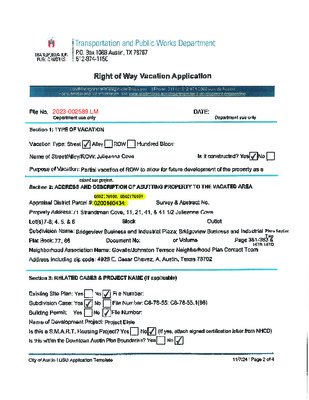
Right of Way Vacation Transmittal Letter LandManagementROW@AustinTexas.gov | Phone: 311 (or 512-974-2000 outside Austin) For submittal and fee information, see www.austintexas.gov/department/land-management Provide a reason for the vaca�on by answering the following ques�ons: 1. Property Type: Residen�al Commercial 2. How was the area to be vacated dedicated? Plat Separate Instrument 3. Did the City purchase the area to be vacated? (i.e., by Street Deed) Yes No 4. Are both the area to be vacated and your property in the same “subdivision”? (They must both be in the same subdivision to be eligible.) Yes No 5. Is the area to be vacated a: Func�onal right-of-way Only dedicated on paper 6. Are there any u�lity lines within the area to be vacated? Yes No If yes, what are your plans for the u�li�es? ________________________________________________ ___________________________________________________________________________________ Applicants should be advised that easements will be retained to protect exis�ng u�li�es, even if u�lity reloca�on is proposed. Also be advised that no structures may be built on, over or under the easements without a license agreement, insurance, and annual fee. 7. How do you plan to develop the area to be vacated? ____________________________________ ___________________________________________________________________________________ 8. Has a site plan been submitted on your project? Yes No 9. Is your project a Unified Development? Yes No 10. Is your project a S.M.A.R.T. Housing Project? Yes No 11. When do you an�cipate star�ng construc�on of the development? ________________________ 12. What is the current zoning on the adjacent proper�es? _________________________________ 13. What is the current status of the adjacent proper�es? __________________________________ 14. What type of parking facili�es currently exist? ________________________________________ 15. Will your parking requirements increase with the expansion? Yes No 16. How will the increase be handled? _________________________________________________ _________________________________________________________________________________ Right of Way Vacation Transmittal Letter LandManagementROW@AustinTexas.gov | Phone: 311 (or 512-974-2000 outside Austin) For submittal and fee information, see www.austintexas.gov/department/land-management 17. Have any agreements or easements been executed with adjacent landowner(s) or in dra� form? Yes No If yes, please provide us with a copy. 18. Does the area to be vacated lie within the Aus�n Downtown Plan (DAP)? Yes No If yes, does it meet DAP criteria? Yes No 19. Does the area to be vacated lie within UT boundaries: East of Lamar Boulevard, west of IH35, north of Mar�n Luther King Boulevard, and south of 45th Street? Yes No 20. Does the proposed vaca�on support the Priority Programs and policy direc�ves set forth in the Imagine Aus�n Comprehensive Plan? Yes No If yes, how ________________________________________________________________________ __________________________________________________________________________________ If you have questions; please email Land Management Department: LandManagementROW@AustinTexas.gov LOCATION MAP Julieanna Cove F#____________ Exhibit “___” (Right-of-way Vacation) Julieanna Cove Legal Description BEING A DESCRIPTION OF A TRACT OF LAND CONTAINING 0.2391 ACRE (10,414 SQUARE FEET) OF LAND MORE OR LESS, OUT OF THE JESSE C. TANNEHILL SURVEY NO. 29, ABSTRACT NO. 22, SITUATED IN THE CITY OF AUSTIN, TRAVIS COUNTY TEXAS, BEING A PORTION OF JULIEANNA COVE (80’ RIGHT-OF-WAY) DEDICATED IN BRIDGEVIEW BUSINESS AND INDUSTRIAL PLAZA, A SUBDIVISION IN TRAVIS COUNTY, TEXAS, ACCORDING TO THE MAP OR PLAT THEREOF RECORDED IN VOLUME 77, PAGES 361- 363 OF THE PLAT RECORDS OF TRAVIS COUNTY, TEXAS (P.R.T.C.T.), SAID 0.2391 ACRE BEING MORE PARTICULARLY DESCRIBED IN TWO PARTS BY METES AND BOUNDS AS FOLLOWS: PO Box 90876 Austin, TX 78709 (512) 537-2384 jward@4wardls.com www.4wardls.com Part 1 – 0.1428 Acre(s) (6,221 Square Feet) BEGINNING, at a 5/8-inch iron rod found at the intersection of the southwest right-of-way line of Levander Loop (Right-of-way varies) with the westerly right-of-way line of said Julieanna Cove, being a point of curvature in the easterly line of Lot 7 of said Bridgeview Business and Industrial Plaza, for the northerly most corner and POINT OF BEGINNING hereof, from which an iron rod with “Brittain & Crawford” cap found for an angle point in the southwest right-of-way line of said Levander Loop, and being an angle point in the northerly line of said Lot 7 bears, along the arc of a curve to the left, whose radius is 1,102.09 feet, whose arc length is 78.53 feet and whose chord bears N44°25’23”W, a distance of 78.51 feet; THENCE, with the southwest right-of-way line of said Levander Loop and the northerly terminus line of said Julieanna Cove, along the arc of a curve to the right, whose radius is 1,102.09, whose arc length is 12.68 feet and whose chord bears S42°01’48”E, a distance of 12.68 feet to a 1/2-inch iron rod with “4Ward- Boundary” cap set for a point of compound curvature hereof, from which a 5/8-inch iron rod found at the intersection of the southwest right-of-way line of said Levander Loop with the easterly right-of-way line of said Julieanna Cove, and being an angle point in the northerly line of Lot 6, Bridgeview Business and Industrial Plaza Section Two, a subdivision in Travis County, Texas, according to the map or plat thereof recorded in Volume 86, Pages 163B-163D (P.R.T.C.T.) bears, along the arc of a curve to the right, whose radius is 1,102.09 feet, whose arc length is 98.95 feet and whose chord bears S39°07’41”E, a distance of 98.92 feet; THENCE, leaving the southwest right-of-way line of said Levander Loop and the northerly terminus line of said Julieanna Cove, over and across said Julieanna Cove, the following four (4) courses and distances: 1) Along the arc of a curve to the right, whose radius is 15.00 feet, whose arc length is 24.12 feet and whose chord bears S06°32’51”W, a distance of 21.60 feet to a 1/2-inch iron rod with “4Ward-Boundary” cap set for an angle point hereof, 2) S52°36’37”W, a distance of 129.47 feet to a 1/2-inch iron rod with “4Ward-Boundary” cap set for a point of curvature hereof, 3) Along the arc of a curve to the right, whose radius is 64.16 feet, whose arc length is 10.83 feet and whose chord bears S57°27’08”W, a distance of 10.82 feet to a 1/2-inch iron rod with “4Ward-Boundary” cap set for a point of tangency hereof, and P:\01489\Metes & Bounds & Certifications\01489_ROW Vacation (Julieanna Cv)_rev.docx Page 1 of 3 F#____________ 4) S62°15’11”W, a distance of 55.23 feet to a 1/2-inch iron rod with “4Ward-Boundary” cap set for a non-tangent point of curvature and the southerly most corner hereof, said point being in the southerly right-of-way line of said Julieanna Cove, and being in the northeast line of Lot 4 of said Bridgeview Business and Industrial Plaza Section Two; THENCE, with the common line of said Julieanna Cove and said Lot 4 of said Bridgeview Business and Industrial Plaza Section Two, and with the common line of said Julieanna Cove and Lots 7 and 8, both of said Bridgeview Business and Industrial Plaza, the following four (4) courses and distances: 1) Along the arc of a curve to the right, whose radius is 80.00 feet, passing at an arc length of 6.29 feet a 5/8-inch iron rod found for the common east corner of said Lots 4 and 8, passing at an arc length of 84.19 feet a 5/8-inch iron rod found for the common east corner of said Lots 7 and 8, and continuing for a total arc length of 156.80 feet, whose chord bears N47°03’11”E, a distance of 132.88 feet to a 1/2-inch iron rod found for a point of reverse curvature hereof, 2) Along the arc of a curve to the left, whose radius is 30.00 feet, whose arc length is 26.32 feet and whose chord bears N78°17’52”E, a distance of 25.48 feet to a 1/2-inch iron rod found for an angle point hereof, 3) N52°27’18”E, a distance of 38.30 feet to a 1/2-inch iron rod found for a point of curvature hereof, and 4) Along the arc of a curve to the left, whose radius is 15.00 feet, whose arc length is 24.85 feet and whose chord bears N05°50’03”E, a distance of 22.11 feet to the POINT OF BEGINNING and containing 0.1428 Acre (6,221 Square Feet) of land, more or less. Part 2 – 0.0963 Acre(s) (4,193 Square Feet) BEGINNING, at a 1/2-inch iron rod found for a point of curvature in the easterly right-of-way line of said Julieanna Cove, and being a point of curvature in the northwest line of said Lot 6 of said Bridgeview Business and Industrial Plaza Section Two, for the northerly most corner and POINT OF BEGINNING hereof, from which a 5/8-inch iron rod found at the beginning of a right-of-way transition between the easterly right-of-way line of said Julieanna Cove with the southwesterly right-of-way line of said Levander Loop, and being a point of curvature in the northwest line of said Lot 6 bears, N52°36’32”E, a distance of 42.64 feet; THENCE, with the common line of said Julieanna Cove and Lots 4-6, all of said Bridgeview Business and Industrial Plaza Section Two, the following two (2) courses and distances: 1) Along the arc of a curve to the left, whose radius is 30.00 feet, whose arc length is 26.25 feet and whose chord bears S27°22’07”W, a distance of 25.42 feet to a 5/8-inch iron rod found for a point of reverse curvature hereof, and 2) Along the arc of a curve to the right, whose radius is 80.00 feet, passing at an arc length of 73.17 feet a 1/2-inch iron rod found for the common north corner of said Lots 5 and 6, passing at an arc length of 160.12 feet a 1/2-inch iron rod found for the common north corner of said Lots 4 and 5, and continuing for a total arc length of 164.69 feet, whose chord bears S61°16’23”W, a distance of 137.11 feet to a 1/2-inch iron rod with “4Ward-Boundary” cap set for the southwest corner hereof, said point being in the north line of said Lot 4; THENCE, leaving the southerly right-of-way line of said Julieanna Cove and the north line of said Lot 4, over and across said Julieanna Cove, the following three (3) courses and distances: 1) N62°16’32”E, a distance of 47.28 feet to a 1/2-inch iron rod with “4Ward-Boundary” cap set for a point of curvature hereof, P:\01489\Metes & Bounds & Certifications\01489_ROW Vacation (Julieanna Cv)_rev.docx Page 2 of 3 F#____________ 2) Along the arc of a curve to the left, whose radius is 132.00 feet, whose arc length is 22.28 feet and whose chord bears N57°26’25”E, a distance of 22.25 feet to a 1/2-inch iron rod with “4Ward-Boundary” cap set for a point of tangency hereof, and 3) N52°36’41”E, a distance of 89.76 feet to the POINT OF BEGINNING and containing 0.0963 Acre (4,193 Square Feet) of land, more or less. NOTE: All bearings are based on the Texas State Plane Coordinate System, Grid North, Central Zone (4203), all distances were adjusted to surface using a combined scale factor of 1.000054689149. See attached sketch (reference drawing: 01489_ROW Vacation-Rev.dwg). _____________________________ Fernando Perez, RPLS #7041 4Ward Land Surveying, LLC 1/10/2025 P:\01489\Metes & Bounds & Certifications\01489_ROW Vacation (Julieanna Cv)_rev.docx Page 3 of 3 01/13/25 JESSE C. TANNEHILL SURVEY NO. 29, ABSTRACT NO. 22 P.O.B. LOT 7 [A] JULIEANNA COVE JULIEANNA COVE (80' R.O.W.) TO BE PARTIALLY (80' R.O.W.) TO BE PARTIALLY VACATED (PART 1) VACATED (PART 1) 0.1428 ACRE(S) 0.1428 ACRE(S) 6,221 SQUARE FEET 6,221 SQUARE FEET OWNER: PROJECT ELSIE LAND, LTD. DOC. NO. 2023089777 O.P.R.T.C.T. LOT 8 [A] A J U LIE (C A O VE C) A C E-S U L-D N N L E V A ( R . N O . W D E R . V L A O R O I E P P.O.B. S ) LOT 6 [B] JULIEANNA COVE (80' R.O.W.) TO BE PARTIALLY VACATED (PART 2) 0.0963 ACRE(S) 4,193 SQUARE FEET LOT 4 [B] [A] BRIDGEVIEW BUSINESS AND INDUSTRIAL PLAZA VOL. 77, PGS. 361-363, P.R.T.C.T. LOT 5 [B] OWNER: PROJECT ELSIE LAND, LTD. DOC. NO. 2023089777 O.P.R.T.C.T. [B] BRIDGEVIEW BUSINESS AND INDUSTRIAL PLAZA SECTION TWO VOL. 86, PGS. 163B-163D, P.R.T.C.T. 0.2391 ACRE JULIEANNA COVE TO BE VACATED City of Austin, Travis County, Texas A Limited Liability Company PO Box 90876, Austin Texas 78709 INFO@4WARDLS.COM (512) 537-2384 TBPELS FIRM 10174300 ANGLE 18.46° 0.2391 ACRE JULIEANNA COVE TO BE VACATED City of Austin, Travis County, Texas A Limited Liability Company PO Box 90876, Austin Texas 78709 INFO@4WARDLS.COM (512) 537-2384 TBPELS FIRM 10174300 ANGLE 18.46° LEGEND 0.2391 ACRE JULIEANNA COVE TO BE VACATED City of Austin, Travis County, Texas A Limited Liability Company PO Box 90876, Austin Texas 78709 INFO@4WARDLS.COM (512) 537-2384 TBPELS FIRM 10174300 PID 283891 | 21 JULIEANNA CV Property Summary Report | 2024 Online Services | Travis Central Appraisal District GENERAL INFO ACCOUNT Property ID: Geographic ID: Type: Zoning: Agent: Legal Description: 283891 0302170108 R LI RYAN LLC FKA MORRISON & HEAD LOT 5 BRIDGEVIEW BUSINESS AND INDUSTRIAL PLAZA SEC 2 Property Use: 69 LOCATION Address: 21 JULIEANNA CV, TX 78702 OWNER Name: Secondary Name: Mailing Address: PROJECT ELSIE LAND LTD 500 W 5TH ST STE 700 AUSTIN TX 78701-3833 Owner ID: % Ownership: Exemptions: 1984120 100.00 Market Area: Market Area CD: Map ID: EAS 030711 PROTEST Protest Status: Informal Date: Formal Date: VALUES CURRENT VALUES Land Homesite: Land Non-Homesite: Special Use Land Market: Total Land: Improvement Homesite: Improvement Non-Homesite: Total Improvement: Market: Special Use Exclusion (-): Appraised: Value Limitation Adjustment (-): Net Appraised: VALUE HISTORY VALUE HISTORY $0 $3,734,955 $0 $3,734,955 $0 $0 $0 $3,734,955 $0 $3,734,955 $0 $3,734,955 Year 2024 2023 2022 2021 2020 Land Market Improvement Special Use Exclusion Appraised Value Limitation Adj (-) Net Appraised $3,734,955 $3,734,955 $1,867,477 $1,700,000 $1,467,304 $0 $0 $0 $0 $0 $0 $0 $0 $0 $0 $3,734,955 $3,734,955 $1,867,477 $1,700,000 $1,467,304 $0 $0 $0 $0 $0 $3,734,955 $3,734,955 $1,867,477 $1,700,000 $1,467,304 Page 1 of 2 Effective Date of Appraisal: January 1 Date Printed: December 11, 2024 Powered By: <True Prodigy> TAXING UNITS Unit Description 01 02 03 0A 2J 68 AUSTIN ISD CITY OF AUSTIN TRAVIS COUNTY TRAVIS CENTRAL APP DIST TRAVIS COUNTY HEALTHCARE DISTRICT AUSTIN COMM COLL DIST Tax Rate 0.950500 0.477600 0.344445 0.000000 0.107969 0.101300 Net Appraised Taxable Value $3,734,955 $3,734,955 $3,734,955 $3,734,955 $3,734,955 $3,734,955 $3,734,955 $3,734,955 $3,734,955 $3,734,955 $3,734,955 $3,734,955 DO NOT PAY FROM THIS ESTIMATE. This is only an estimate provided for informational purposes and may not include any special assessments that may also be collected. Please contact the tax office for actual amounts. IMPROVEMENT LAND Land LAND Description Land DEED HISTORY Acres 4.0830 SQFT 177,855 Cost per SQFT Market Value Special Use Value $21.00 N/A N/A Deed Date Type Description Grantor/Seller Grantee/Buyer Book ID Volume Page Instrument 8/7/23 SW 7/14/20 SW 1/7/04 SW 7/21/99 SW 7/19/99 SW 2/7/89 TD SPECIAL WARRANTY SPECIAL WARRANTY SPECIAL WARRANTY SPECIAL WARRANTY SPECIAL WARRANTY TRUSTEE DEED NEW DAIRY TEXAS LLC MILK PRODUCTS LP RANDLE GLENN L PROJECT ELSIE LAND LTD NEW DAIRY TEXAS LLC MILK PRODUCTS LP RANDLE GLENN L CENTEX LAND COMPANY SCHOLL PETER & JAMES CUMMINGS CENTEX LAND COMPANY 2023089777 2020127049 2004006851 TR 1999077970 TR 1999070163 TR 00000 00000 00000 00000 00000 00000 10870 01193 Page 2 of 2 Effective Date of Appraisal: January 1 Date Printed: December 11, 2024 Powered By: <True Prodigy> PID 283890 | 41 JULIEANNA CV Property Summary Report | 2024 Online Services | Travis Central Appraisal District GENERAL INFO ACCOUNT Property ID: Geographic ID: Type: Zoning: Agent: Legal Description: 283890 0302170107 R LI RYAN LLC FKA MORRISON & HEAD LOT 6 BRIDGEVIEW BUSINESS AND INDUSTRIAL PLAZA SEC 2 Property Use: 69 LOCATION Address: 41 JULIEANNA CV, TX 78702 OWNER Name: Secondary Name: Mailing Address: PROJECT ELSIE LAND LTD 500 W 5TH ST STE 700 AUSTIN TX 78701-3833 Owner ID: % Ownership: Exemptions: 1984120 100.00 Market Area: Market Area CD: Map ID: EAS 030711 PROTEST Protest Status: Informal Date: Formal Date: VALUES CURRENT VALUES Land Homesite: Land Non-Homesite: Special Use Land Market: Total Land: Improvement Homesite: Improvement Non-Homesite: Total Improvement: Market: Special Use Exclusion (-): Appraised: Value Limitation Adjustment (-): Net Appraised: VALUE HISTORY VALUE HISTORY $0 $2,173,479 $0 $2,173,479 $0 $0 $0 $2,173,479 $0 $2,173,479 $0 $2,173,479 Year 2024 2023 2022 2021 2020 Land Market Improvement Special Use Exclusion Appraised Value Limitation Adj (-) Net Appraised $2,173,479 $2,173,479 $1,086,740 $1,086,740 $1,086,740 $0 $0 $0 $0 $0 $0 $0 $0 $0 $0 $2,173,479 $2,173,479 $1,086,740 $1,086,740 $1,086,740 $0 $0 $0 $0 $0 $2,173,479 $2,173,479 $1,086,740 $1,086,740 $1,086,740 Page 1 of 2 Effective Date of Appraisal: January 1 Date Printed: December 11, 2024 Powered By: <True Prodigy> TAXING UNITS Unit Description 01 02 03 0A 2J 68 AUSTIN ISD CITY OF AUSTIN TRAVIS COUNTY TRAVIS CENTRAL APP DIST TRAVIS COUNTY HEALTHCARE DISTRICT AUSTIN COMM COLL DIST Tax Rate 0.950500 0.477600 0.344445 0.000000 0.107969 0.101300 Net Appraised Taxable Value $2,173,479 $2,173,479 $2,173,479 $2,173,479 $2,173,479 $2,173,479 $2,173,479 $2,173,479 $2,173,479 $2,173,479 $2,173,479 $2,173,479 DO NOT PAY FROM THIS ESTIMATE. This is only an estimate provided for informational purposes and may not include any special assessments that may also be collected. Please contact the tax office for actual amounts. IMPROVEMENT LAND Land LAND Description Land DEED HISTORY Acres 2.3760 SQFT 103,499 Cost per SQFT Market Value Special Use Value $21.00 N/A N/A Deed Date Type Description Grantor/Seller Grantee/Buyer Book ID Volume Page Instrument 8/7/23 SW 7/14/20 SW 1/7/04 7/9/99 2/7/89 SW SW TD SPECIAL WARRANTY SPECIAL WARRANTY SPECIAL WARRANTY SPECIAL WARRANTY TRUSTEE DEED NEW DAIRY TEXAS LLC MILK PRODUCTS LP RANDLE GLENN L CENTEX LAND COMPANY SCHOLL PETER & JAMES CUMMINGS PROJECT ELSIE LAND LTD NEW DAIRY TEXAS LLC MILK PRODUCTS LP RANDLE GLENN L CENTEX LAND COMPANY 2023089777 2020127049 2004006851 TR 1999070163 TR 00000 00000 00000 00000 10870 01193 Page 2 of 2 Effective Date of Appraisal: January 1 Date Printed: December 11, 2024 Powered By: <True Prodigy> PID 187758 | 71 STRANDTMAN CV Property Summary Report | 2024 Online Services | Travis Central Appraisal District GENERAL INFO ACCOUNT Property ID: Geographic ID: Type: Zoning: Agent: Legal Description: Property Use: LOCATION Address: 187758 0200160434 R LI RYAN LLC FKA MORRISON & HEAD LOT 5-8 BRIDGEVIEW BUSINESS AND INDUSTRIAL PLAZA LOT 3-4 * BRIDGEVIEW BUSINESS & INDUSTRIAL PLAZA SEC 2 69 71 STRANDTMAN CV, TX 78702 OWNER Name: Secondary Name: Mailing Address: PROJECT ELSIE LAND LTD 500 W 5TH ST STE 700 AUSTIN TX 78701-3833 Owner ID: % Ownership: Exemptions: 1984120 100.00 Market Area: Market Area CD: Map ID: EAS 020211 PROTEST Protest Status: Informal Date: Formal Date: VALUES CURRENT VALUES Land Homesite: Land Non-Homesite: Special Use Land Market: Total Land: Improvement Homesite: Improvement Non-Homesite: Total Improvement: Market: Special Use Exclusion (-): Appraised: Value Limitation Adjustment (-): Net Appraised: VALUE HISTORY VALUE HISTORY $0 $12,393,690 $0 $12,393,690 $0 $1,847,386 $1,847,386 $14,241,076 $0 $14,241,076 $0 $14,241,076 Year 2024 2023 2022 2021 2020 Land Market Improvement Special Use Exclusion Appraised Value Limitation Adj (-) Net Appraised $12,393,690 $12,393,690 $8,242,461 $8,262,460 $5,709,681 $1,847,386 $4,170,725 $0 $10,244 $1,751,305 $0 $0 $0 $0 $0 $14,241,076 $16,564,415 $8,242,461 $8,272,704 $7,460,986 $0 $0 $0 $0 $0 $14,241,076 $16,564,415 $8,242,461 $8,272,704 $7,460,986 Page 1 of 3 Effective Date of Appraisal: January 1 Date Printed: December 11, 2024 Powered By: <True Prodigy> TAXING UNITS Unit Description 01 02 03 0A 2J 68 AUSTIN ISD CITY OF AUSTIN TRAVIS COUNTY TRAVIS CENTRAL APP DIST TRAVIS COUNTY HEALTHCARE DISTRICT AUSTIN COMM COLL DIST Tax Rate 0.950500 0.477600 0.344445 0.000000 0.107969 0.101300 Net Appraised Taxable Value $14,241,076 $14,241,076 $14,241,076 $14,241,076 $14,241,076 $14,241,076 $14,241,076 $14,241,076 $14,241,076 $14,241,076 $14,241,076 $14,241,076 DO NOT PAY FROM THIS ESTIMATE. This is only an estimate provided for informational purposes and may not include any special assessments that may also be collected. Please contact the tax office for actual amounts. IMPROVEMENT Improvement #1: State Code: F2 MFG/ENG'G/LAB Description: MAJOR IND MFG Improvement Value: N/A Main Area: Gross Building Area: 64,525 417,704 Type Description Class CD Exterior Wall Number of Units EFF Year Built 1st Floor PAVED AREA COMMCL FINISHOUT COLDSTG VAULT LG 1st Floor SPRINKLER HEADS 1st Floor 1ST 551 881 272 1ST 491 1ST MEZZ Mezzanine 541 501 482 FENCE COMM LF CANOPY LIGHT POLES S CA A S S S S S C8 A S 0 1 1 0 0 0 0 0 1 1 0 1987 1987 1987 1987 1987 1987 1987 1987 1987 1987 1987 Year 1987 1987 1987 1987 1987 1987 1987 1987 1987 1987 1987 SQFT 39,814 260,000 13,290 11,636 14,159 64,525 3,774 6,778 2,680 1,038 10 Improvement Features 1ST Ceiling Factor: 10, Floor Factor: 1ST, Grade Factor: A, Shape Factor: R 1ST Ceiling Factor: 18, Shape Factor: R, Grade Factor: A, Floor Factor: 1ST 1ST Shape Factor: R, Grade Factor: A, Floor Factor: 1ST, Ceiling Factor: 16 MEZZ Shape Factor: R, Ceiling Factor: 10, Grade Factor: A, Floor Factor: MEZZ Improvement #2: State Code: F2 SVC/REPAIR GAR'G Improvement Value: N/A Description: SVC/REPAIR GAR'G Main Area: Gross Building Area: 6,399 19,758 Type Description Class CD Exterior Wall Number of Units EFF Year Built 1ST 881 402 501 328 491 1st Floor S A COMMCL FINISHOUT CARWASH SELF-SERVE A A CANOPY I MEZZ COMM (STG) S SPRINKLER HEADS Improvement Features 1ST Shape Factor: R, Grade Factor: A, Ceiling Factor: 20, Floor Factor: 1ST 0 1 1 1 1 0 1988 1988 1988 1988 1988 1988 Year 1988 1988 1988 1988 1988 1988 SQFT 6,399 1,580 1,580 2,220 1,580 6,399 Page 2 of 3 Effective Date of Appraisal: January 1 Date Printed: December 11, 2024 Powered By: <True Prodigy> LAND Land LAND Description Land DEED HISTORY Acres 9.4840 SQFT 413,123 Cost per SQFT Market Value Special Use Value $30.00 N/A N/A Deed Date Type Description Grantor/Seller Grantee/Buyer Book ID Volume Page Instrument 8/7/23 SW 7/14/20 SW 9/4/97 SW 2/23/96 SW 7/7/86 WD SPECIAL WARRANTY SPECIAL WARRANTY SPECIAL WARRANTY SPECIAL WARRANTY WARRANTY DEED NEW DAIRY TEXAS LLC MILK PRODUCTS L L C, MILK BORDEN/MEADOW GOLD DAIRIES INC SUPERIOR DAIRIES INC PROJECT ELSIE LAND LTD NEW DAIRY TEXAS LLC MILK PRODUCTS L L C BORDEN/MEADOW GOLD DAIRIES INC SUPERIOR DAIRIES INC 2023089777 2020127048 13014 01426 12692 02077 09780 00010 Page 3 of 3 Effective Date of Appraisal: January 1 Date Printed: December 11, 2024 Powered By: <True Prodigy> Permitting and Development Center | 6310 Wilhelmina Delco Drive, Austin, TX 78752 | (512) 978-4000 Property Profile Report W R O R O W General Information Location: Parcel ID: Grid: 71 STRANDTMAN CV 0200160434 ML20 Planning & Zoning *Right click hyperlinks to open in a new window. Future Land Use (FLUM): Industry Regulating Plan: No Regulating Plan Zoning: LI-CO-NP Zoning Cases: Zoning Ordinances: Zoning Overlays: Neighborhood Plan: C14-2022-0121 NPA-2022-0016.02 030327-11a Airport Overlay: CONTROLLED COMPATIBLE LAND USE AREA ADU Approximate Area Reduced Parking Residential Design Standards: LDC/25-2-Subchapter F Selected Sign Ordinances Wildland Urban Interface: Proximity Class - Within 150 feet of a wildland area GOVALLE Zoning Map Infill Options: Small Lot Amnesty Infill Option Neighborhood Restricted Parking Areas: -- Mobile Food Vendors: Historic Landmark: -- -- Urban Roadways: Yes Zoning Guide The Guide to Zoning provides a quick explanation of the above Zoning codes, however, the Development Assistance Center provides general zoning assistance and can advise you on the type of development allowed on a property. Visit Zoning for the description of each Base Zoning District. For official verification of the zoning of a property, please order a Zoning Verification Letter. General information on the Neighborhood Planning Areas is available from Neighborhood Planning. Imagery Map Environmental Fully Developed Floodplain: No FEMA Floodplain: .2 PCT ANNUAL CHANCE FLOOD HAZARD, .2 PCT ANNUAL CHANCE FLOOD Austin Watershed Regulation Areas: URBAN Watershed Boundaries: Colorado River Creek Buffers: Edwards Aquifer Recharge Zone: Edwards Aquifer Recharge Verification Zone: Erosion Hazard Zone Review Buffer: Political Boundaries No No No No Jurisdiction: AUSTIN FULL PURPOSE Council District: 3 County: TRAVIS School District: Austin ISD Community Registry: Austin Independent School District, Austin Lost and Found Pets, Austin Neighborhoods Council, Del Valle Community Coalition, East Austin Conservancy, El Concilio Mexican-American Neighborhoods, Friends of Austin Neighborhoods, Govalle/Johnston Terrace Neighborhood Plan Contact Team, Greater East Austin Neighborhood Association , Guadalupe Neighborhood Development Corporation, Homeless Neighborhood Association, Neighborhood Empowerment Foundation, Neighbors United for Progress, Preservation Austin, River Bluff Neighborhood Assoc., SELTexas, Sierra Club, Austin Regional Group, Tejano Town Vicinity Map The Information on this report has been produced by the City of Austin as a working document and is not warranted for any other use. No warranty is made by the City regarding its accuracy or completeness. Date created: 1/10/2023