REGULAR MEETING of the URBAN TRANSPORTATION COMMISSION TUESDAY APRIL 2, 2024, at 5:00pm BOARDS AND COMMISSIONS ROOM 1101 CITY HALL- 301 W 2nd St. AUSTIN, TEXAS Some members of the Urban Transportation Commission may be participating by videoconference. The meeting may be viewed online at: http://www.austintexas.gov/page/watch- atxn-live. Public comment will be allowed in-person or remotely by telephone. Speakers may only register to speak on an item once either in-person or remotely and will be allowed up to three minutes to provide their comments. Registration no later than noon the day before the meeting is required for remote participation. To register please call or email the staff liaison in advance at (512)-974-3428 or natalie.leone@austintexas.gov no later than noon on Monday April 1, 2024 with the following information: name, item number(s) to speak on, telephone number, and email address. CURRENT BOARD MEMBERS/COMMISSIONERS: Vacant - (District 1) Melissa Ortiz- (District 2) Arlin Alvarez- (District 3) Susan Somers, Chair- (District 4) Daniel Kavelman-( District 5) Edward Smith- (District 6) Diana Wheeler- (District 7) Athena Leyton- (District 8) Spencer Schumacher- (District 9) Ruven Brooks, Vice Chair- (District 10) Deshon Brown- (Mayoral Appointee) AGENDA CALL TO ORDER PUBLIC COMMUNICATION: GENERAL The first 10 speakers signed up prior to the meeting being called to order will each be allowed a three-minute allotment to address their concerns regarding items not posted on the agenda. APPROVAL OF MINUTES 1. Approve the minutes of the Urban Transportation Commission REGULAR MEETING on March 5, 2024. DISCUSSION ITEMS 2. Discussion on Green Streets Initiative Presenter: Kevin Howard, Urbinden DISCUSSION AND ACTION ITEMS 3. Discussion and approval of a recommendation on South Central Waterfront regarding multimodal transportation and transit supportive density Presenter: April Geruso, Planning Department 4. Discussion and approval of a recommendation on Equitable Transit-Oriented Development 5. Discussion and approval of a recommendation on Living Streets/Pedestrian Vibrancy 6. Discussion and approval of a recommendation on Austin-Bergstrom International Airport Facilitator: Susan Somers, Chair Facilitator: Susan Somers, Chair (ABIA) street safety Facilitator: Daniel Kavelman 7. Discussion and approval of the Officer Elections Facilitator: Susan Somers, Chair COMMITTEE UPDATES 8. Update from Commissioner Schumacher from the Downtown Commission regarding actions taken at the March 20, 2024 meeting 9. Update from Commissioner Wheeler from the Joint Sustainability Commission regarding 10. Update from Commissioner Schumacher from the Bicycle Advisory Council regarding actions taken at the March 27, 2024 meeting actions taken at the March 19, 2024 meeting …
GREEN STREETS INITIATIVE Street Trees Keep Austin Cool March 26th, 2024 Prepared by: Kevin Howard (Urbinden) & Jana McCann, FAIA (McCann Adams Studio) WHERE ARE OUR HEAT ISLANDS? • The worst urban heat island effects follow our major street network. • Yet, streets are how we get around, where we walk, bike, roll, catch transit - exactly where it must be cooler. • AND, lower-income residents – who depend more on transit - live on the hotter, east side. • The worsening heat islands are a major public health risk for everyone, but especially our most vulnerable communities. Heat Map of Austin showing the yellow, hottest areas focused in East Austin and Downtown WHY AUSTIN NEEDS GREEN STREETS • Address challenges of densification and climate change using public rights-of-way. • Less private yard space and busier streets mean that we will rely on trees in the public realm for health and public safety • Increasing vegetation - particularly trees - is an effective way to make Austin more livable and resilient to the effects of climate change. • Street trees are essential urban infrastructure, not just “nice-to-haves” or “beautification” Example of continuous shade trees at curbside, providing both shade and protection from road for sidewalk users WHERE ARE THE TREES? • Austin over-relies on private yards and preserved natural areas for its urban forest, which are concentrated in wealthier parts of town. • Low-income and BIPOC communities are disproportionately impacted by extreme heat • Yet, street trees are one of the most desired community benefits, according to many public surveys and in the “Contracts with Voters” in recent bond elections. The City’s Tree Canopy Map shows lack of “shade equity” on the east side. 1. The LACK OF LEADERSHIP means that review staff are conducting reviews and making decisions, with little guidance and support. Departmental Silos preclude integrated and responsive urban design. 2. Austin’s RULES & REGULATIONS are not aligned with City and community priorities: if they were, street trees would be required of most public and private development. 3. The PERMITTING PROCESS – eliminating license agreement process and 4. reduce required discretion and inconsistent implementation. It is more EXPENSIVE to plant street trees in public ROWs: we need to assure they can be subsidized for transit and affordable housing projects. Street trees compete with utilities for space in the ROW and generally come out the losers – along with …
South Central Waterfront Combining District & Density Bonus Program Urban Transportation Commission April 2, 2024 South Central Waterfront Vision Framework Plan Adopted June 6, 2016 2 Streets and Light Rail 3 City Council Resolution 20220915-090 Allow increased development only through the Density Bonus Program. Maximize community benefits and infrastructure investments. Create a Density Bonus Program “akin” to Downtown and that supports Project Connect. Allow entitlements for required infrastructure and community benefits. Ensure entitlements meet market demand. Create enhanced environmental standards and protections. Program to be re-evaluated/updated at least every five years. 4 Approach Since Council Resolution The SCW regulations will be implemented by: – Council adoption of an optional set of regulations and bonus program through the creation of a Combining District and a Density Bonus Program (spring 2024). – City-initiated rezoning of non PDA, PUD, and Planned Development Agreement properties in the district (summer 2024). First reevaluation within 1-2 years. 5 District Boundary Expansion 6 Combining District Density Bonus General Provisions (Policies, procedures, and who can participate) Land Use Standards (Permitted and conditional land uses) Development Standards (What can be built and where) Design Standards (How it will look) Definitions Procedures/Requirements “Gate Keeper” Requirements – – – Affordable Housing Environmental Protection Improved Streetscape and Built Environment In-Lieu Fees and Dedications On-Site Community Benefits Eligible for Bonus Area 7 7 Subdistricts Council approval is required to exceed FAR maximums and heights Project Connect Rail Alignment 8 Critical Water Quality Zones Existing Overlays remain, with some elements being superseded by SCW Combining District 9 Permitted land uses support: Land Uses – Transit – Pedestrian use – Mixed-use – Creative Enterprise – Recreation and Entertainment Activity 10 Parks & Open Space Required publicly accessible Open Space (5% of site) Parkland dedication may be credited towards Parks Fee-in-Lieu amount Buildout of parks amenities is a community benefit available for bonus area Both parkland dedication and buildout must meet PARD criteria and be accepted by the PARD Director 11 Density Distribution Areas (DDAs) Floor-to-Area Ratio (FAR) is calculated separately for each DDA and FAR maximums apply separately. Not representative of actual site plan DDAs shall be no greater than 90,000 sq. ft. Internal circulation routes are required along DDA boundaries for internal pedestrian circulation. 12 SCW Density Bonus Program On-site Requirements: Enhanced Environmental Standards Streetscape and …
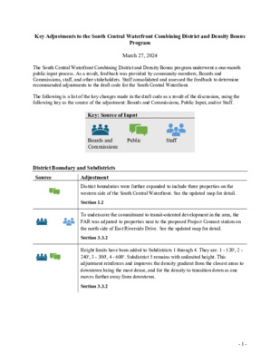
Key Adjustments to the South Central Waterfront Combining District and Density Bonus Program March 27, 2024 The South Central Waterfront Combining District and Density Bonus program underwent a one-month public input process. As a result, feedback was provided by community members, Boards and Commissions, staff, and other stakeholders. Staff consolidated and assessed the feedback to determine recommended adjustments to the draft code for the South Central Waterfront. The following is a list of the key changes made in the draft code as a result of the discussion, using the following key as the source of the adjustment: Boards and Commissions, Public Input, and/or Staff. Key: Source of Input Boards and Commissions Public Staff District Boundary and Subdistricts Source Adjustment Section 1.2 Section 3.3.2 District boundaries were further expanded to include three properties on the western side of the South Central Waterfront. See the updated map for detail. To underscore the commitment to transit-oriented development in the area, the FAR was adjusted to properties near to the proposed Project Connect station on the north side of East Riverside Drive. See the updated map for detail. Height limits have been added to Subdistricts 1 through 4. They are: 1 - 120', 2 - 240', 3 - 300', 4 - 600'. Subdistrict 5 remains with unlimited height. This adjustment reinforces and improves the density gradient from the closest areas to downtown being the most dense, and for the density to transition down as one moves further away from downtown. Section 3.3.2 - 1 - Land Use Source Adjustment Cocktail Lounges above 3,500sf in size will trigger the need for a conditional use permit. The conditional use permit process will better assist in the review and regulation of entertainment / nightlife noise disturbances. The Custom Manufacturing land use has been limited to 2,500sf. The limitation will deter larger single-purpose land uses and encourage more flexible development that supports smaller creative businesses. Section 2.3.1(C)(4) Section 2.3.1(D)(1) Adjustment Section 2.7(C) Section 4.4.3 Shade provisions increased for cantilevered, affixed, and freestanding options. Trees will still be the dominant shade mechanism, but this change allows for strong urban design and diversity in design of the urban space. This is also consistent with activities in other urban areas in the city. An additional internal circulation route type with a bicycle lane was added. This addition increases bicycle connectivity within the South Central Waterfront area and facilitates safe separation of …
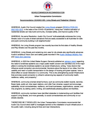
BOARD/COMMISSION RECOMMENDATION Urban Transportation Commission Recommendation 20240402‐005: Living Streets and Pedestrian Vibrancy WHEREAS, Austin City Council created the Living Streets program [RESOLUTION NO. 20211021-027] in the wake of the COVID-19 pandemic, noting that “creative activation of residential streets can help build community, increase safety, and improve quality of life;” WHEREAS, the same Resolution, Austin City Council “enthusiastically embraces the Living Streets vision of a suite of street activations that are easily accessible to all Austinites for safe and joyful community-building in all neighborhoods;” WHEREAS, the Living Streets program has recently launched its first slate of Healthy Streets and Play Streets over the past few months; WHEREAS, Living Streets and reclaiming civic uses for city streets also significantly advances Austin’s ambitious Vision Zero and safety goals recorded in the Austin Strategic Mobility Plan and Vision Zero planning; WHEREAS, in 2023 the United States Surgeon General published an advisory report regarding the nation’s loneliness epidemic as a major public health concern and identified one of the major pillars to solving the loneliness epidemic as social infrastructure, writing, “many factors that influence social connection are environmental. Decisions about the layout of our cities, from the usability and reach of public transportation to the design of housing and green spaces, have a direct effect on social interaction in a community. This is why strengthening social infrastructure that promotes social connection is critical to advancing key aspects of community health, resilience, safety, and prosperity;” WHEREAS, community-oriented street furniture, such as community bulletin boards, benches, flower beds, public art, bike repair stations, and Little Free Libraries, support and encourage walkability; social connectedness; resiliency; and local businesses, organizations, causes, and City programs, by adding useful, inviting, and aesthetically-pleasing places and facilities; WHEREAS, community members have identified obstacles to implementing such facilities that support Living Streets, and more generally, to social connectedness and community on our streets citywide; THEREFORE BE IT RESOLVED; the Urban Transportation Commission recommends that Austin City Council direct staff to investigate barriers to the installation of such infrastructure in the public realm, including along lot lines and near intersections; BE IT FURTHER RESOLVED, the Urban Transportation Commission urges Austin City Council and Austin Transportation and Public Works to propose and pass code amendments to remove barriers to community-oriented street furniture in the public realm and allow residents to freely install social infrastructure; BE IT FURTHER RESOLVED, the Urban Transportation Commission recommends that Austin City …
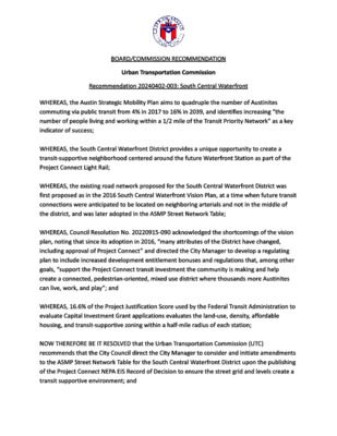
BOARD/COMMISSION RECOMMENDATION Urban Transportation Commission Recommendation 20240402‐003: South Central Waterfront WHEREAS, the Austin Strategic Mobility Plan aims to quadruple the number of Austinites commuting via public transit from 4% in 2017 to 16% in 2039, and identifies increasing “the number of people living and working within a 1/2 mile of the Transit Priority Network” as a key indicator of success; WHEREAS, the South Central Waterfront District provides a unique opportunity to create a transit‐supportive neighborhood centered around the future Waterfront Station as part of the Project Connect Light Rail; WHEREAS, the existing road network proposed for the South Central Waterfront District was first proposed as in the 2016 South Central Waterfront Vision Plan, at a time when future transit connections were anticipated to be located on neighboring arterials and not in the middle of the district, and was later adopted in the ASMP Street Network Table; WHEREAS, Council Resolution No. 20220915‐090 acknowledged the shortcomings of the vision plan, noting that since its adoption in 2016, “many attributes of the District have changed, including approval of Project Connect” and directed the City Manager to develop a regulating plan to include increased development entitlement bonuses and regulations that, among other goals, “support the Project Connect transit investment the community is making and help create a connected, pedestrian‐oriented, mixed use district where thousands more Austinites can live, work, and play”; and WHEREAS, 16.6% of the Project Justification Score used by the Federal Transit Administration to evaluate Capital Investment Grant applications evaluates the land‐use, density, affordable housing, and transit‐supportive zoning within a half‐mile radius of each station; NOW THEREFORE BE IT RESOLVED that the Urban Transportation Commission (UTC) recommends that the City Council direct the City Manager to consider and initiate amendments to the ASMP Street Network Table for the South Central Waterfront District upon the publishing of the Project Connect NEPA EIS Record of Decision to ensure the street grid and levels create a transit supportive environment; and BE IT FURTHER RESOLVED, that the UTC appreciates staff’s responsiveness to community concerns by increasing the FAR limit on the north side of East Riverside Drive, the UTC recommends that the City Council alter the South Central Waterfront Combining District and Density Bonus regulations to maximize access to the future Waterfront Light Rail Station by reclassifying all parcels located directly on Riverside Drive to the east of Congress Ave to Subdistrict 4 or 5. Motioned …
BOARD/COMMISSION RECOMMENDATION Urban Transportation Commission Recommendation 20240402‐004: Equitable Transit‐Oriented Development Overlay WHEREAS the Austin Strategic Mobility Plan aims to quadruple the number of Austinites commuting via public transit from 4% in 2017 to 16% in 2039, and identifies increasing “the number of people living and working within a 1/2 mile of the Transit Priority Network” as a key indicator of success; WHEREAS the Federal Transit Administration’s software for ridership forecasting uses the number of people who can walk from their homes or jobs to a transit stop as its major input and forecast ridership is a major factor in FTA funding decisions WHEREAS regardless of current zoning the presence of a transit stop will increase the demand for residential and commercial spaces regardless of base zoning, including those that are single family zoned, as is pointed out in RESOLUTION NO. 20230309‐016 WHEREAS COUNCIL restrictions on which current base zones may be considered for the ETOD Overlay has resulted in a relatively small area being eligible for ETOD zoning NOW, THEREFORE, BE IT RESOLVED the Urban Transportation Commission recommends that the City Council direct the City Manager to direct staff to consider additional base zones for the ETOD Overlay subject to the considerations and limitations that staff has already used in selecting base zones as overlay candidates but omitting the restriction to non‐single family zones, with a goal of enabling application of the ETOD Overlay to at least 50% of the land area within one‐half mile of Phase 1 Austin Light Rail alignment and Priority Extensions.
BOARD/COMMISSION RECOMMENDATION URBAN TRANSPORTATION COMMISSION Recommendation Number 20240402-006: Traffic Safety Around Austin-Bergstrom International Airport WHEREAS, Recommendation 2024214-008, passed by the Airport Advisory Commission, seeks improved safety measures and enhanced communication with APD, AFD, EMS, TPW and TXDOT to avoid future incidents and to manage traffic in order that the roadways in and out of the airport remain safe and operational; and WHEREAS, Fatal highway incidents on Northbound 183 (11/14/2022) and on Eastbound SH71 (11/15/2023) resulted in lane closures; and WHEREAS, Fatal vehicle-related incidents occurred on the secure airfield side on 4/20/2023 and 10/31/2023; and WHEREAS, Neighborhoods surrounding the airport are considered by the City of Austin Equity Analysis to be Most or Medium-High Vulnerable; and WHEREAS, The City of Austin Transportation and Public Works department is currently working on a intersection safety project at Burleson Road and SH 183; and WHEREAS, The City of Austin, through its Strategic Mobility Plan, is committed to ending traffic deaths as part of its Vision Zero program; NOW, THEREFORE, BE IT RESOLVED that the Urban Transportation Commission recommends that Department of Aviation staff coordinate with Austin Police (APD), Fire (AFD) and Emergency Medical Services (EMS); Austin Transportation Public Works (TPW) Department Vision Zero Program; and the Texas Department of Transportation (TXDOT) #EndTheStreak Program to promote pedestrian, bicycle, driver and vehicle safety in and around Austin-Bergstrom International Airport and also in order to keep at least one lane in each direction including airport entrances and exits open under most circumstances. Motioned by: Commissioner Kavelman Seconded by: Date of Approval: Record of the vote: Attest:
Resolution on ETOD Phase 1 Overlays Ruven Brooks Urban Transportation Commission April 2, 2024 We need more housing near transit • ASMP calls for four times as many people using transit as do today • To use transit, people have to live or work within 10 minutes walk/ride of a transit stop • Council resolutions 20230309-016 and 20240201-054 request that City of Austin staff propose bonus programs and other mechanisms for increasing the amount of housing within a half mile of Phase 1 Austin Light Rail and Priority Extensions stops (10 minute walk) Proposed ordinance creates two overlays • “ETOD Overlay combining district (ETOD) will prohibit or make conditional those land uses that are not transit-supportive” • “ETOD Density Bonus combining district (DBETOD) will create a density bonus program that: • Allows residential uses, • Modifies development regulations to increase maximum height (up to 120 feet total), and • Modifies various site development standards.” • Both overlays will be applied within a half-mile of Austin Light Rail stops, including Priority Extensions DBETOD District • Intended to be similar to the DB90 (VMU2 replacement) Combining • Property owners must request a rezoning to add DB90 • Requires a Planning Commission recommendation • Requires a Council action Constraints on transit supportive overlays • Areas around train stops have a wide variety of current zoning • Council specifically limited the new overlay to non single family zoned property (20240201-054) Upcoming City-led ETOD Implementation efforts • Comprehensive Plan (Imagine Austin) amendment to incorporate ETOD • ETOD Overlay • ETOD Overlay (Phase 1 Light Rail Transit + Priority Extensions) • ETOD Overlay (Comprehensive) • Other Transit-Supportive Code Amendments • South Central Waterfront Regulations • Downtown Parking Requirements • Density Bonus Zoning District (Vertical Mixed Use 2 Density Bonus Program Replacement) • Citywide Compatibility modifications • HOME Initiative (One-Unit Minimum Lot Size) • Updates to East Riverside Corridor Plan & Regulating Plan • NLTC and SCTC station area vision plans adoption by City Council • Phase 1 Overlay • Only very few areas available for the overlay • Might be because areas are covered by other code amendments • East Riverside Corridor and Regulating Plan • Might be because of limitation to non single family zoning Alternative: Drop the constraint limiting the bonus plan to non single family zones • Give staff flexibility to suggest modifications to the DBETOD overlay to accommodate single family homes • …
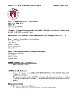
URBAN TRANSPORTATION MEETING MINUTES (Tuesday, April 2, 2024) URBAN TRANSPORTATION COMMISSION REGULAR MEETING MINUTES Tuesday, April 2, 2024 The Urban Transportation Commission convened in a REGULAR meeting on Tuesday, April 2, 2024, at City Hall in Austin, Texas. Chair Somers called the Urban Transportation Commission Meeting to order at 5:02 p.m. Board Members/Commissioners in Attendance: Susan Somers, Chair Arlin Alvarez Daniel Kavelman Spencer Schumacher Deshon Brown Board Members/Commissioners in Attendance Remotely: Ruven Brooks, Vice Chair Athena Leyton Diana Wheeler Edward Smith PUBLIC COMMUNICATION: GENERAL Adam Greenfield – Item 5 APPROVAL OF MINUTES 1. Approve the minutes of the URBAN TRANSPORTATION COMMISSION REGULAR MEETING on 3/5/2024. The minutes from the meeting of 3/5/2024 were approved on Commissioner Somers’s motion, Commissioner Schumacher’s second on a 9-0 vote; Commissioner Ortiz absent. One vacancy on the dais. DISCUSSION ITEMS 2. Discussion on Green Streets Initiative The commission received a presentation from Kevin Howard, Urbinden 1 URBAN TRANSPORTATION MEETING MINUTES (Tuesday, April 2, 2024) DISCUSSION AND ACTION ITEMS 3. Discussion and approval of a recommendation on South Central Waterfront regarding multimodal transportation and transitive supportive density The commission received a presentation from April Geruso with Chad Sharrard, Sravya Garladenne and Tyler Tripp available to answer questions. Amendment 1: Commissioner Kavelman’s motion, Commissioner Somers’s second on a 9- 0 vote; Amendment 2: Commissioner Schumacher’s motion, Commissioner Kavelman’s second on an 8-1 vote, Commissioner Alvarez opposing; Amendment 3: Commissioner Kavelman’s motion, Commissioner Alvarez’s second on a 9-0 vote. Approved on Commissioner Schumacher’s motion, Commissioner Kavelman’s second on a 9-0 vote; Commissioner Ortiz absent. One vacancy on the dais. 4. Discussion and approval of a recommendation on Equitable Transit-Oriented Development Approved on Commissioner Brooks’ motion, Commissioner Somers’s second on a 6-1 vote, Commissioner Brown opposing; Commissioner Alvarez abstaining. Commissioners Ortiz and Smith absent. One vacancy on the dais. 5. Discussion and approval of a recommendation on Living Streets/Pedestrian Vibrancy Approved on Commissioner Somers’s motion, Commissioner Schumacher’s second on an 8-0 vote; Commissioners Ortiz and Smith absent. One vacancy on the dais. 6. Discussion and approval of a recommendation on Austin-Bergstrom International Airport (ABIA) street safety Amendments Approved on Commissioner Somers’s motion, Commissioner Schumacher’s second on a 7-0 vote, Approved as a whole on a 7-0 vote; Commissioner Alvarez abstaining. Commissioners Ortiz and Smith absent. One vacancy on the dais. 7. Discussion and approval of Officer Elections Susan Somers was elected Chair on Commissioner Schumacher’s motion, Commission Kavelman’s second …