Item 3a Staff Report C14-2021-0111 300-301 Pressler &1501 W 3rd parcel2 — original pdf
Backup
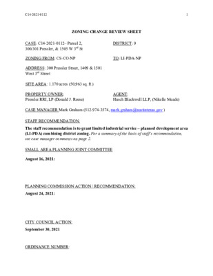
C14-2021-0112 1 ZONING CHANGE REVIEW SHEET CASE: C14-2021-0112– Parcel 2, 300/301 Pressler, & 1505 W 3rd St DISTRICT: 9 ZONING FROM: CS-CO-NP TO: LI-PDA-NP ADDRESS: 300 Pressler Street, 1409 & 1501 West 3rd Street SITE AREA: 1.170 acres (50,963 sq. ft.) PROPERTY OWNER: Pressler RRI, LP (Donald J. Reese) AGENT: Husch Blackwell LLP, (Nikelle Meade) CASE MANAGER Mark Graham (512-974-3574, mark.graham@austintexas.gov ) STAFF RECOMMENDATION: The staff recommendation is to grant limited industrial service – planned development area (LI-PDA) combining district zoning. For a summary of the basis of staff’s recommendation, see case manager comments on page 2. SMALL AREA PLANNING JOINT COMMITTEE August 16, 2021: PLANNING COMMISSION ACTION / RECOMMENDATION: August 24, 2021: CITY COUNCIL ACTION: September 30, 2021 ORDINANCE NUMBER: C14-2021-0112 2 ISSUES The project area is within the Waterfront Overlay and will be reviewed by the Small Area Plan Joint Commission on August 16, 2021, prior to Planning Commission. A height variance, increasing maximum building height to 75 feet was approved prior to Zoning Application. Parking reductions proposed in the PDA are being reviewed by ATD. CASE MANAGER COMMENTS: There are three case numbers assigned to one development project. Parcels are separated by rights-of-way but will be developed and operated as a single development. Parcel 1 is case C14- 2021-0111; Parcel 2 is C14-2021-0112; and Parcel 3 is C14-2021-0113. Location and Access The three rezoning tracts are all south of the active Union Pacific railroad tracks. Vehicle access to the development will be from both Pressler and Paul Streets. Since those accesses rely on at- grade railroad crossings, there will be safety arms that lower across the streets as trains approach. The applicant is proposing to connect public sidewalk access to the park through the development from both streets. Site and Surrounding Area Parcel 2 is a 1.170-acre (50,963 sq. ft.) tract, between Parcels 1 & 3, located west of Pressler Street extended. The south edge of the parcel is fenced and has dense vegetation so that there are not currently views of or access to the park or lake beyond. The site is elevated relative to the adjoining Ladybird Lake - Lamar Beach public park. Development site is benched and mostly level at the railroad tracks. Generally, the area slopes towards the lake (south) with particularly steep grades along the park, on park land. There are trails within the park that the developer intends to connect to the subject site. The trails include the Lance Armstrong Bikeway and the Ann and Roy Butler Hike and Bike Trail. There are also several specialized playing fields for little league baseball and soccer in the park close to the proposed development. The site is separated from the Ladybird lake by Reserve Road that provides vehicle access to and from the sport fields and Austin Animal Shelter via West Cesar Chavez Street and Stephen F. Austin Drive. Cesar Chavez St. and the on/off ramps are also physical barriers between the subject development and waterfront amenities. Existing and Proposed Zoning The current zoning on Parcel 2, is general commercial service – conditional overlay – neighborhood plan (CS-CO-NP) combining district zoning. Applicant requests limited industrial service – planned development area (LI-PDA) combining district zoning for the entire 3.189-acre (138,912 sq. ft.) development site (all three buildings). The proposed PDA is to maintain general commercial services – mixed use (CS-MU) combining district zoning for use and development regulations with some modifications. (see Proposed PDA Uses and Development Regulations, below). C14-2021-0112 3 The total number of proposed residential units in all three buildings is 326. Applicant plans to build 98 units on Parcel 1, 143 units on Parcel 2 and 85 units on Parcel 3. There is no displacement of residents on Parcel 1 or 2. 2 residential units will be razed on Parcel 3. The number of bedrooms for the new units have not been determined. Proposed PDA Uses and Development Regulations: 1. A “site” for the purpose of development of each parcel shall include all sites that are part of the same development permit; 2. Amendment of Section 25-6-478(E)(3) of the Land Development Code (the “Code”) to read as follows: “Twenty (20) spaces for every dedicated and reserved car-sharing, bicycle-sharing, scooter-sharing, or TNC vehicle parking or storage space provided in connection with a program approved by the Director.” 3. CS-MU uses, and 4. CS-MU site development regulations, except as follows: a. A maximum reduction of the minimum off-street parking requirements set forth in the Code by 40% b. A maximum increase of the maximum compact parking requirements set forth in the Code by 40% (also being reviewed by ATD) c. Reduce minimum front yard setback from 10 ft to 5 ft d. Reduce minimum street side yard setback from 10 ft to 0 ft e. Minimum site area for multi-family residential is 0 f. Increase maximum building height from 60 feet to 75 feet to add one story. Neighborhood Plan The subject development is located within the Old West Austin Neighborhood Plan boundary. That Plan was adopted without a future land use map (FLUM) so a plan amendment is not required. Comprehensive Planning staff provided comments in this report related to the goals of the Old West Austin Plan for this area known generally in the plan as “South of 6th Street.” The Plan acknowledges the commercial and office concentration on West 5th and 6th Streets and sets the goal of getting mixed use development including residential uses. This area had warehouses and open storage with buses and trucks in recent years. The plan is focused on replacing the industrial uses with residential, office and commercial uses. Imagine Austin Comprehensive Plan The West 5th Street Activity Corridor is located less than 400 feet from the subject property. Activity Corridors are intended to be areas that support people living, working, shopping, accessing services, watching people, exercising, and hanging out close to home. They are characterized by a variety of activities and types of buildings located along the roadway — shopping, restaurants and cafés, parks, schools, houses, apartments, civic buildings, churches, mixed-use buildings, and offices. The proposed residential development provides homes for people who could participate in those activities. C14-2021-0112 4 BASIS OF RECOMMENDATION: The Staff recommendation is to grant limited industrial – planned development area – neighborhood plan (LI-PDA-NP) combining district zoning, based on the following: 1. The proposed zoning should be consistent with the purpose statement of the district sought. Limited industrial service (LI) district is intended as an area primarily for commercial services and limited manufacturing uses, generally on moderately sized sites. Planned development area (PDA) combining district is intended for combination with selected commercial and industrial base districts, in order to modify base district provisions as necessary to allow for appropriate industrial and commercial uses or to reflect the terms of a Planned Development Area agreement following annexation of properties subject to such an agreement. – Neighborhood plan (NP) district denotes a tract located within the boundaries of an adopted Neighborhood Plan. The applicant proposes to build 326 residential units in three buildings on 3.189 acres on Parcels designated as 1, 2 and 3. The (PDA) planned development area provides the permitted uses and development regulations for the development. The proposed general commercial services-mixed use (CS-MU) uses and site development regulations with the proposed amendments, would permit building the proposed development. Specifically, the mixed use adds residential uses to the limited industrial base zoning. The amendment (with variance already approved) from CS building height maximum of 60 feet to 75 feet would permit the proposed building height. The modification of minimum site area requirements for multi-family residential to 0. The reduction is off-street parking requirements by 40%. The increase of compact parking requirements set forth in the code by 40%. The allowance of 20 spaces for every dedicated and reserved car-sharing, bicycle-sharing, scooter- sharing, or TNC vehicle parking or storage space provided with a program approval by the director. 2. Zoning should not constitute a grant of special privilege to an individual owner; Granting of the request should result in an equal treatment of similarly situated properties There are three nearby buildings that have built multifamily residential and mixed use buildings with the requested LI-PDA-NP zoning: • 1301 W. 5th St. • 1601 -1611 W. 5th St • 300 North Lamar Blvd. The Clark The Gables at 5th AMLI 300 3. Zoning changes should promote compatibility with adjacent and nearby uses. The Old West Austin Neighborhood Plan encourages a transition from industrial uses to mixed-use, office and residential uses. The proposed development proposes 326 units of residential uses and has the flexibility with the requested zoning to provide general commercial service uses. The plan to provide a public connection through the development at Pressler and Paul Streets would be an amenity for the neighborhood. C14-2021-0112 5 Site North South East West EXISTING ZONING AND LAND USES: Zoning Land Uses CS-CO-NP (Parcel 1) Vacant land LI-CO-NP, LI-PDA-NP Convenience storage, “The Clark” MU Multifamily Residential with some ground floor commercial on W 5th St. Ladybird Lake – Lamar Beach Park Park land P-NP P-NP CS-CO-NP (Parcel 2) Small buildings, possible dwellings NEIGHBORHOOD PLANNING AREA: Old West Austin (no FLUM or regulating plan) TIA: The Traffic Impact Analysis is deferred to site plan application, when land use and intensity will be finalized. WATERSHED: Lady Bird Lake OVERLAYS: Waterfront Overlay (Lamar Beech), Old West Austin-NP SCHOOLS: AISD: Matthews Elementary O’Henry Middle Austin High NEIGHBORHOOD ORGANIZATIONS Austin Independent School District Austin Lost and Found Pets Austin Neighborhoods Council Friends of Austin Neighborhoods Homeless Neighborhood Association Neighborhood Empowerment Foundation Old West Austin Neighborhood Association Old West Austin Neighborhood Plan Contact Team Preservation Austin SELTexas Save Barton Creek Assn. Save Historic Muny District Shoal Creek Conservancy Sierra Club, Austin Regional Group TNR BCP - Travis County Natural Resources C14-2021-0112 6 AREA CASE HISTORIES: Number Request Commission City Council CS-MU-CO-NP to LI-PDA Not scheduled Not Scheduled To grant Apvd. 09/26/2002 Ord.# 20020926-026 To grant To grant To grant Apvd. Ord.# 20080327-059 20080306-056 Apvd.11/21/2013 Ord.# 20131121-096 Apvd.10/08/2015 Ord.# 20151008-014 To grant Apvd. 12/11/2014 Ord.# 20141211-163 C14-2021-0081 5th and Walsh In Review C14-02-0112 Old West Austin Plan C14-2007-0237 Old West Austin NP Area Vertical MU C14-2013-0101 501 Oakland Ave. C14-2015-0078 1411 W. 5th St. & 403 Paul St. C14-2014-0134 1301 W 5th St Adopt NP Overlay. Rezone 416 ac to add NP and change 62 tracts base district; and adopt lists of prohibited and conditional uses for the listed tracts. Opt in/Opt-out process. Rezone 31 ac to add V combining district. Generally along W 5th and 6th St. and Lamar Blvd. Rezone 0.12 ac. from LO-V-NP to GR-V-CO-NP Rezone from LI-CP-NP to LI-PDA- NP. A. list of prohibited uses. B. list of conditional uses. C. Development standards. D. vehicle trip limt. E. Minimum 3,000 sq. ft. of commercial or retail uses on first floor. Rezone from LI-CO-NP to LI- PDA. CO may develop and use per LI regulations, except: maximum 2,000 vehicles/day; no vehicle access to W 5th St; multifamily use permitted; list of Conditional Uses; laundry is conditional use If exceeds 6,000 sq. ft.; construction sales and service is condition use if exceeds 10,000 sq. ft.; list of Prohibited uses; list of site development standards. Rezone 1.098 ac from LI-CO-NP to CS-CO-NP. CO commercial use max 10%; list of Conditional uses; list of Prohibited uses. C14-2012-0015 315 Pressler St To grant Apvd. 08/02/2012 Ord.# 20120802-090 C14-2021-0112 7 RELATED CASES: C14-2021-0112, Parcel 2 C14-2021-0113, Parcel 3 SP-2020-0362C, Site Plan C14-2012-0008: Rezone 1.191 ac. from LI-CO-NP & CS-1-MU-CO to CS-NP, Ord.# 20120802-089 Restrictive Covenants Document 2017186267, Subsurface Pond RC Document 2017186269, Integrated Pest Management RC LEGAL DESCRIPTION: A DESCRIPTION OF 1.170 ACRES (APPROXIMATELY 50,963 SQUARE FEET) IN OUTLOT 1, DIVISION "Z" OF ORIGINAL CITY OF AUSTIN, TEXAS, IN TRAVIS COUNTY, TEXAS, BEING ALL OF A 1.170 ACRE TRACT CONVEYED TO PRESSLER RRI, LP, IN A SPECIAL WARRANTY DEED EXECUTED APRIL 19, 2017 AND RECORDED IN DOCUMENT NO. 2017068325 OF THE OFFICIAL PUBLIC RECORDS OF TRAVIS COUNTY, TEXAS; SAID 1.170 ACRES BEING MORE PARTICULARLY DESCRIBED BY METES AND BOUNDS. OTHER STAFF COMMENTS: Comprehensive Planning The subject property is located south of railroad tracks on a vacant 1.072 acre site. The property is located less than 500 feet from the 5th Street Activity Corridor and is located within the Old West Austin Neighborhood Planning Area. Surrounding land uses include railroad tracks, a public storage facility, and multi-story mixed use building to the north; to the south is the WAYA Cesar Chaves Sports Fields; to the east is vacant land, retail uses and Austin Pets Alive; and to the west are two other parcels connected to this case, which are used for vehicle parking or contain small warehouse buildings. The proposal is a mixed-use project, which would be up to 75 feet tall. Connectivity West 5th Street is a heavily travelled collector and arterial road, which has public sidewalks located on both sides of the street, which are often intruded upon by large driveways. There are no bike lanes along this street. A Cap Metro Transit stop is located approximately 400 feet from the property, along West 5th Street. To the south and west is the Lance Armstrong Bikeway. The mobility options are average (although the curb cuts and condition of the public sidewalks need improvement) and connectivity options are good. Old West Austin Neighborhood Plan The Old West Austin Neighborhood Plan (OWANP) is one of the few neighborhood plans that does not have a Future Land Use Map. The OWANP identifies this property as South of Sixth Street District, which includes Sixth and Fifth Streets two principal commercial corridors in the OWANP (p. 19). C14-2021-0112 8 The following Text, Goals and Objectives found on pages 23 and 24 of the OWANP discuss this project area: • Commercial and office uses are concentrated on Lamar, 5th Street, 6th Street, and West Lynn. • A few existing industrial uses are located between 5th and 6th Streets. Some residential structures are now used as offices, especially on 5th Street, 6th Street, and Baylor. (pg. 9). • From pg. 12 of the OWANP, which lists of number of neighborhood plan goals for this planning area, with the top goal being ‘1.) Encourage mixed uses’ (p 12.). LAND USE / ZONING: • The neighborhood planning team has identified "neighborhood friendly" commercial areas where office, retail, and residences can be mixed vertically and horizontally. These areas include West 5th and 6th Streets between Lamar and Mopac, Lamar Boulevard between Town Lake and Enfield, and those properties that already have commercial zoning on the central commercial service corridor on West Lynn from 10th to 13th Streets ("Downtown Clarksville"). • Pg. 23 Neighborhood-oriented commercial uses with modest parking requirements are preferred. Goal 1 - Encourage Mixed Uses (pg. 23) Obj. 1.1 – Allow mixed uses in selected areas, as follows: Action 1: Apply the Neighborhood Plan Combining District special use category “Neighborhood Mixed Use Building” and the Mixed Use Combining District to all properties between the Union Pacific Railroad and the center line of 5th Street, to encourage the conversion of this land to a mix of residential and other uses. The neighborhood will encourage developers to include residences of an appropriate size for families with children. Mixed-use development would be permitted but not required. LAND USE / ZONING: For decades, the Old West Austin Neighborhood has resisted intense pressure to change existing residential properties to commercial use. Despite these efforts, a significant loss in residential use has occurred. The goal of the Neighborhood Planning Team is to protect existing residential property and encourage the development of new residential property by supporting mixed-use development in certain areas of the neighborhood. The development of commercial properties under the banner of mixed use with token residential space, such as penthouses, is not supported by the plan. A goal of the neighborhood plan is at least three square feet of residential space for every new square foot of commercial space. Neighborhood-oriented commercial uses with modest parking requirements are preferred. The planning team has identified types of uses that should be: permitted, not permitted, and conditionally permitted in CS, CS-1 and LI zoning in the neighborhood. Development of buildings with a mix of office and residential can result in complementary parking. Retail can be included in certain areas as parking allows. C14-2021-0112 9 Goal 2 - Protect the Character of the Neighborhood (pg. 24) Obj 2.1 – Encourage commercial uses that support the neighborhood. Goal 3 – Maintain Social and Economic Diversity of Residents (p 28) Obj. 3.1 - Provide Additional Moderately-Priced Housing Rezoning Proposals: This neighborhood has been under great pressure to accommodate commercial uses within its residential core, and is in danger of being eroded from its edges. This could create a self-fulfilling prophesy of residents leaving and commercial uses moving in, and putting pressure on the next tier of residents. Any proposed rezoning should be consistent with the land use and zoning proposals of this plan. The boundaries of the districts described below are illustrated in the map "Old West Austin Neighborhood Plan – Neighborhood Districts." (pg. 30) The Old West Austin Neighborhood Plan policies supports neighborhood friendly, neighborhood serving mixed-use adjoining the railroad track and south of West 5th Street. Imagine Austin The Imagine Austin Growth Concept Map identifies this project as being located near an Activity Corridor (West 5th Street) and less than a half of a mile from the Downtown Regional Center. Activity Corridors are intended to allow people to reside, work, shop, access services, people watch, recreate, and hang out without traveling far distances. They are characterized by a variety of activities and types of buildings located along the roadway — shopping, restaurants and cafés, parks, schools, single-family houses, apartments, public buildings, houses of worship, mixed-use buildings, and offices. The following Imagine Austin policies are applicable to this case: · LUT P3. Promote development in compact centers, communities, or along corridors that are connected by roads and transit that are designed to encourage walking and bicycling, and reduce health care, housing and transportation costs. · LUT P4. Protect neighborhood character by directing growth to areas of change that includes designated redevelopment areas, corridors and infill sites. Recognize that different neighborhoods have different characteristics and new and infill development should be sensitive to the predominant character of these communities. · LUT P5. Create healthy and family-friendly communities through development that includes a mix of land uses and housing types and affords realistic opportunities for transit, bicycle, and pedestrian travel and provides both community gathering spaces, parks and safe outdoor play areas for children. Based upon mobility and connectivity strengths in the area, a myriad of adjoining uses (civic and commercial), the Old West Austin and the Imagine Austin policies listed above that support mixed use, and this project being situated near an Activity Corridor, this proposed mixed use project supports the Imagine Austin Comprehensive Plan. C14-2021-0112 10 Environmental 1. The site is located over the Edwards Aquifer Recharge Zone. The site is located in the Lady Bird Lake Watershed of the Colorado River Basin, which is classified as an Urban Watershed by Chapter 25-8 of the City's Land Development Code. It is in the Desired Development Zone. 2. Zoning district impervious cover limits apply in the Urban Watershed classification. 3. According to floodplain maps there is a floodplain within or adjacent to the project location. Based upon the location of the floodplain, offsite drainage should be calculated to determine whether a Critical Water Quality Zone exists within the project location. 4. Standard landscaping and tree protection will be required in accordance with LDC 25-2 and 25-8 for all development and/or redevelopment. 5. At this time, site specific information is unavailable regarding vegetation, areas of steep slope, or other environmental features such as bluffs, springs, canyon rimrock, caves, sinkholes, and wetlands. 6. This site is required to provide on-site water quality controls (or payment in lieu of) for all development and/or redevelopment when 8,000 s.f. cumulative is exceeded, and on site control for the two-year storm. 7. At this time, no information has been provided as to whether this property has any preexisting approvals that preempt current water quality or Code requirements. Parks and Recreation PR1: Parkland dedication will be required for the new residential units proposed by this development, multifamily with LI-PDA zoning, at the time of subdivision or site plan, per City Code § 25-1-601. Whether the requirement shall be met with fees in-lieu or dedicated land will be determined using the criteria in City Code Title 25, Article 14, as amended. Should fees in- lieu be required, those fees shall be used toward park investments in the form of land acquisition and/or park amenities within the surrounding area, per the Parkland Dedication Operating Procedures § 14.3.11 and City Code § 25-1-607 (B)(1) & (2). The proposed development also includes a separate Park Improvement Agreement. The Agreement details that a new sidewalk will be built at Lamar Beach, Town Lake Metro Park, as well as surface parking and a bike/ped connection to the park through to Pressler Street. The improvements are part of an Agreement to allow for a vehicular connection across parkland to the proposed development from Cesar Chavez. If the applicant wishes to discuss parkland dedication requirements in advance of site plan or subdivision applications, please contact this reviewer: thomas.rowlinson@austintexas.gov. At the applicant’s request, PARD can provide an early determination of whether fees in-lieu of land will be allowed. C14-2021-0112 11 Site Plan SP 1 SP 2 SP 3 Transportation Any new development is subject to Subchapter E. Design Standards and Mixed Use. Additional comments will be made when the site plan is submitted. The site is subject to compatibility standards. The site is within the Lamar Waterfront Overlay District. Heights are limited to 60 feet, and surface parking is prohibited within the Overlay. 1. The Austin Strategic Mobility Plan (ASMP), adopted 04/11/2019, calls for 70 feet and 92 feet of right-of-way for Pressler Street and identifies sufficient right-of-way for 3rd Street. It is recommended that 35 feet of right-of-way from the existing centerline and 46 feet of right of way from the future centerline should be dedicated for Pressler Street. 2. There is a proposed Urban Trail adjacent to this site, southern property boundary. The easement required is a minimum of 20 ft as this allows for a 12 ft trail (minimum trail width per the urban trails plan) and room for maintenance activity. This is the same for Tier I and Tier II trails. 3. Assessment of required transportation mitigation, including the potential dedication of right of way and easements and participation in roadway and other multi-modal improvements, will occur at the time of site plan/subdivision application. A traffic impact analysis shall be required at the time of site plan if triggered per LDC 25-6-113. 4. ATD recommends that off-site transportation mitigations at the time of site plan are inclusive and considerate of any development(s) proposed within the three zoning cases noted in the applicant’s request. This would include C14-2021-0113, C14- 2021-0112 and C14-2021-0111. Name Existing ROW Pavement ASMP Classification Sidewalks Bicycle Route ASMP Required ROW 48’ 70’-92’ 30’ ~70’-85’ 50’ New roadway 2 1 No No No No Capital Metro (within ¼ mile) Yes Yes Pressler Street 3rd Street C14-2021-0112 12 Austin Water Utility AW1. The landowner intends to serve the site with City of Austin water and wastewater utilities. The landowner, at own expense, will be responsible for providing any water and wastewater utility improvements, offsite main extensions, utility relocations and or abandonments required by the land use. The water and wastewater utility plan must be reviewed and approved by Austin Water for compliance with City criteria and suitability for operation and maintenance. Depending on the development plans submitted, water and or wastewater service extension requests may be required. All water and wastewater construction must be inspected by the City of Austin. The landowner must pay the City inspection fee with the utility construction. The landowner must pay the tap and impact fee once the landowner makes an application for a City of Austin water and wastewater utility tap permit. INDEX OF EXHIBITS TO FOLLOW Exhibit A: Zoning Map Exhibit B: Aerial Map Exhibit C: Parcel Map for Overall Project Exhibit D: Decision Sheet – Board of Adjustment- Building Height Variance Exhibit E: Educational Impact Statement 02-0112 HIGH SCHOOL H R A L E V A E N Z T O M S R A I L R O A D O P A C N B R A M P AUSTIN H IGH SCH OOL LI-NP ( ( 05-0025 ( C14-05-0025 NO-MU-CO-NP ( LO-NP ( ( E V A A T S U G U A 02-0112 UNZ C E S A N M R C H A V E Z T O M OPAC SB TO 5TH EB RA MP PUD-NP C814-82-006.01(83) C814-82-006.01(83) SP-04-0689B 02-0112 O P A C S B R A M P O FC . T ( LL S OFC. GO-NP 80-87 ( MF-4-NP E B P M A C CS-MU-CO-NP 6 81-2 E FIC F O P - - 0 3 2 0 6 4 S C S E FIC F O 80-90 ( ( ( GO-NP CONDOS. R. T N ( 7 9 - 1 6 2 ( LO-NP 9 4 84-2 E R ( A C AY D ( G. C N LR C814-82-006.01(83) C814-82-006.01(83) PUD-NP C A T E X E S A R C S & N E W O C H AIN S A W A UT O R E PAIR R E P AIR ( 02-0112 CS-MU-V-CO-NP C14-2007-0237 W 5 T NT APTS. MF-4-HD-NP ( LO-NP ( ( LO-NP GO-NP E FIC F O 3 5 7-1 6 MF-4-NP C. F O C. F O GO-NP 4 -5 9 7 S T N E M T R PA A MF-4-NP ( ( ( ( CONDOS. P79-11 SF-3-NP ( ( MF-4-NP ( ( ( SF-3-NP C14-04-0149.43 ( 04-0149.43 ( ( ( MF-4-HD-NP MF-4-NP ( MF-4-HD-NP SF-3-HD-NP ( MF-4-H-HD-NP C14-04-0149.21 ( C14H-2008-0019 ( C14-04-0149.26 ( ( SF-3-HD-NP ( C14-04-0149.17 ( ( ( MF-4-HD-NP ( MF-4-H-HD-NP ( C14H-2009-0023 S. ( T P ( A C14-04-0149.23 MF-4-HD-NP S. T ( P A ( C14-04-0149.24 SF-3-HD-NP ( MF-4-HD-NP ( C14H-2018-0013 ( ( ( SF-3-HD-NP MF-4-HD-NP SF-3-H-HD-NP ( ( W 9TH ST ( APTS. SF-3-NP ( MF-4-NP ( ( ( ( ( MF-4-NP ( T R S E L S S E R P SF-3-HD-NP ( ( ( MF-3-NP C14H-06-0022 MF-4-HD-NP ( NO-MU-H-CO-NP H76-01 T N S N T LY S E W MF-4-NP APTS. ( 04-0149.22 ( ( C14-04-0149.22 SF-3-HD-NP ( MF-4-HD-NP ( ( MF-4-HD-NP ( ( C14-04-0149.20 SF-3-HD-NP ( MF-4-NP ( ( H H W 6T ( SF-3-H-HD-NP C14H-80-025 SF-3-HD-NP ( ( ( MF-4-HD-NP E ALF S V D A ( SF-3-HD-NP N A L H HIG ( MF-4-HD-NP ( SF-3-NP ( ( T ( LO-NP O FC . ( MF-4-NP ( MF-4-HD-NP SF-3-HD-NP GO-NP ( LO-MU-NP LO-CO-NP SF-2-HD-NP ( MF-4-NP ( ( ( 2 9.3 4 1 4-0 0 ( MF-4-NP ( ( ( ( 1 2 1 4-0 9 ( C14-04-0149.32 SF-3-NP ( ( SF-3-NP 74-62 MF-4-NP ( ( L F GO-NP WIN R O D SF-3-NP ( MF-4-NP ( SF-3-H-HD-NP ( 0 4-2 H7 CS-MU-V-CO-NP ( C14-2007-0237 PARK P-NP ( SF-3-NP SF-3-NP ( C14-04-0149.37 ( ( ( C14-04-0149.36 ( MF-4-NP ( C14-04-0149.33 SF-3-NP ( 02-0112 APTS. MF-4-NP ( APTS. MF-4-NP ( T ( ( 04-0149.33 N S O S L E N SF-3-NP C14-04-0149.41 ( ( W 8T ( ( H S T ( APARTMENTS ( ( ( ( U RA MF-4-NP CS-1-MU-V-CO-NP LO-CO-NP ( H S T TA RES SP94-0104CS CS-MU-V-CO-NP ( C14-2007-0237 GO-CO-NP T L S L 79-124 E W O GO-NP P 79-5 3 4 -1 2 9 S . O D N O C LO-NP C14-2015-0044 O F C . LR-MU-CO-NP 82-81 LO-NP LI-PDA-NP C14-05-0038 LO-V-CO-NP C A R W A S H CS-MU-V-CO-NP 98-0066 C14-2007-0237 C14-2018-0030 LO-NP LR-NP 05-0038 LI-CO-NP AUTO SALES GR-MU-V-CO-NP C14-2007-0237 85-265 02-0112 LI-CO-NP LO-NP OFF. 82-206 85-111 C14-2013-0101 C14-2007-0237 GR-V-CO-NP LR-V-NP OFF. PARKIN G CS-MU-CO-NP C14-06-0176 LO-MU-NP STRIP MALL 02-0112 C14-2007-0237 CS-MU-V-CO-NP G P KIN S O C H 11 R Y S 3-1 A P D 9 O P S B C14-02-0112 T L S U A P C14-2015-0078 LI-PDA-NP P O H Y S D O B LI-CO-NP 02-0112 ! ! ! ! ( ! ! ! ! ! ! LI-CO-NP ! ! ! W 3RD ST ( ! ! LO-NP E V D A N A L K A O ( GR-CO-NP GO-NP C14-2013-0138 LO-CO-NP 84-219 2 1-6 7 GR-V-CO-NP C14-2009-0166 C14-2010-0115 G KIN R A P 85-352 C14-2007-0237 . A T IO S DIO U T D S A R CS-MU-V-CO-NP 6 4 1-1 ELEC. W 7 HSE. CS-MU-CO-NP SP91-0100A SP-06-0365C SP85-171 ! ! SP-87-011 ! ! ! ( ! ! ! ! ! ! W H ! SE ! ! 02-0112 LI-CO-NP ! C14-2012-0008 ! ! ! CS-CO-NP ! ! ! ! ! ! ! ! ! ! ! ! SP-02-0352C ! ! ! ! ! SP95-0075C MINI-STO TELEPH O NE T R A G E LI-PDA-NP C14-2014-0134 02-0112 D S R A H C R O ( LI-NP P-NP P-NP ( SF-3-NP SF-3-HD-NP MF-4-NP ( SF-3-NP 2007-0237 CS-MU-V-CO-NP C14-2007-0237 C14H-03-0016 SF-3-H-HD-NP MF-4-H-HD-NP T N S A H T R A H S. T P A ( CS-MU-CO-HD-NP ( W 6TH ST MF-4-HD-NP 93-59 ( C14H-2010-0006 C14H-92-0002 SF-3-HD-NP MF-4-HD-NP C14H-2010-0006 C14-2007-0237 CS-MU-CO-HD-NP SP96-0216D ( 02-0112 PUD-NP C14-2007-0237 CS-MU-V-CO-NP SPC-03-0018C None SP-96-0329C ! ! C814-96-0002 E FIC F O E ! ! PUD-NP STO R AG CS-MU-V-CO-NP ( C14-2007-0237 C14H-04-0016 CS-MU-CO-H-NP ( ! ! ! CS-MU-CO-NP T H S S L A W ! ! CS-MU-CO-NP ! SHOPPING CENTER OFFICE OFFICE C14-2007-0237 02-0112 ( CS-MU-CO-NP ! FUR ! ! N./UPH ( OL. CS-MU-V-CO-NP C14-2007-0237 ! C14-2007-0237 CS-MU-V-CO-NP ! ! ! ( ( ( SP85-001 LI-CO-NP OFFICE ! ! ! P O H S L A T N E O R T U A ( W 4TH ST IRON AND STEEL YARD OFF. BLD G. ( N84-013 LI-CO-NP T S S R E Y A S MASSAGE THERAPY ( ( E IC F F O 02-0112 ! C14-2012-0015 ! CS-CO-NP ! ! ! ! ! ! ! ! RESERVE RD TOWNE LAKE PARK LI-CO-NP SPC97-111C HUMANE SOCIETY ANIMAL SHELTER P-NP P-NP P-NP S T E P H E N F A T O C E S A R C E B R A M P 02-0112 P-NP LI-NP 02-0112 LI-CO-NP TRAIN STATION S P C 9 2-0 0 3 1 C Y.M.C.A. TOWNE LAKE PARK W C E S A R C H AV EZ ST 88-0033 02-0112 P SOFTBALL FIELD PARKING LI-NP BOAT RAMP BASEBALL FIELD LI-NP 02-0112 STE P H E N F A U STIN D R L O U N E F F R D P SOCCER FIELDS SUBJECT TRACT ! ! ! ! ! ! PENDING CASE ZONING BOUNDARY 87-112 ± P ZONING ZONING CASE#: C14-2021-0112 This product is for informational purposes and may not have been prepared for or be suitable for legal, engineering, or surveying purposes. It does not represent an on-the-ground survey and represents only the approximate relative location of property boundaries. 1 " = 400 ' This product has been produced by the Housing and Planning Department for the sole purpose of geographic reference. No warranty is made by the City of Austin regarding specific accuracy or Created: 7/1/2021 LI-PDA-NP LI-CO-NP PUD-NP LI-NP GR-MU-V-CO-NP CS-MU-V-CO-NP CS-MU-CO-NP LO-NP CS-MU-CO-NP D N A L K A O E V A GR-V-CO-NP LR-V-NP LI-CO-NP T L S U A P LI-PDA-NP CS-MU-V-CO-NP W 5TH ST LI-CO-NP W 3RD ST LI-CO-NP T R S E L S S E R P LI-CO-NP C14-2021-0112 CS-CO-NP H22 CS-CO-NP LI-PDA-NP C E S T S A E P R C H H E A V E N F T Z A T R N P-NP RESERVE TO CESAR CHAVE B RA W M P P-NP B E Z E V A H C R A S E C P M A R E H P E T S O T P-NP W C E S A R A V V E R Z A M W P B P-NP R C H C T E O S A R R E S C E H A V E Z S T S T E P A T C E H E O C B R E S A A R N F M P P-NP RESERVE RD P-NP ± 1'' = 150' SUBJECT TRACT ZONING BOUNDARY ! ! ! ! ! ! PENDING CASE CREEK BUFFER 300 & 301 Pressler and 1505 W. 3rd Street - Parcel 2 ZONING CASE#: LOCATION: SUBJECT AREA: GRID: MANAGER: C14-2021-0112 300 & 301 Pressler; 1505 W. 3rd St 1.17 Acres H22 MARK GRAHAM This map has been produced by the Communications Technology Management Dept. on behalf of the Planning Development Review Dept. for the sole purpose of geographic reference. No warranty is made by the City of Austin regarding specific accuracy or completeness. Copyright nearmap 2015 Exhibit A: Map of All Parcels Within the Proposed Overall Project HB: 4838-2996-8606.7 CITY OF AUSTIN Board of Adjustment Decision Sheet D-7 DATE: Monday June 14, 2021 CASE NUMBER: C15-2021-0035 ___Y____Thomas Ates ___Y____Brooke Bailey ___Y____Jessica Cohen ___Y____Melissa Hawthorne ___Y____Don Leighton-Burwell ___Y____Rahm McDaniel ___Y____Darryl Pruett ___Y____Agustina Rodriguez ___-____Michael Von Ohlen ___Y____Nicholl Wade ___-____Vacant ___-____Kelly Blume (Alternate) ___Y____Carrie Waller (Alternate) ___-____Vacant (Alternate) APPLICANT: Nikelle Meade OWNER: Pressler RRI, LP ADDRESS: 1409, 1501, 1505 W. 3rd St. and 300, 301 Pressler St. VARIANCE REQUESTED: The applicant is requesting a variance(s) from the Land Development Code, Section 25-2-736 (D) (Lamar Subdistrict Regulations) to increase height limit from 60 feet (maximum allowed) to 75 feet (requested) in order to erect Multi-Family Residential Mixed Use in a “CS-CO-NP & LI-CO-NP”, General Commercial Services – Conditional Overlay - Neighborhood Plan and Limited Industrial – Conditional Overlay Neighborhood Plan zoning district. (Old West Austin Neighborhood Plan) BOARD’S DECISION: BOA April 12, 2021cancelled; May 10, 2021 POSTPONED TO JUNE 14, 2021 DUE TO LACK OF BOARD MEMBERS/VOTES; June 14, 2021 The public hearing was closed by Chair Jessica Cohen, Board Member Brooke Bailey motions to Grant; Board Member Rahm McDaniel seconds on a 10-0 vote; GRANTED. FINDING: 1. The Zoning regulations applicable to the property do not allow for a reasonable use because: they limit the number of people who have direct access to and views of adjacent parkland and Lady Bird Lake, which is a barrier to achieving the purpose of the Waterfront Overlay, this property is currently a former commercial and industrial site and approval would allow for the redevelopment of the property with a greater capacity for new housing supply than otherwise possible, substantial parkland improvements, new pedestrian amenities, enhanced connectivity and access to public transit. 2. (a) The hardship for which the variance is requested is unique to the property in that: the property has a long and narrow configuration, the property is also a bluff, adjacent to parkland to the south and an active railroad to the north, with heritage trees, slopes, easements and a required setback from an erosion hazard zone and the planned public plaza, park entrance, railroad crossing arms, trail, required on-site fire lanes, firefighter walkway, and loading all present additional hardships. (b) The hardship is not general to the area in which the property is located because: a property of this size and configuration is not typical of the area and there are few other properties that are enclosed by adjacent dedicated City owned parkland, active railroad tracks and sloped creek banks 3. The variance will not alter the character of the area adjacent to the property, will not impair the use of adjacent conforming property, and will not impair the purpose of the regulations of the zoning district in which the property is located because: approval will only enhance the area’s character since the project would include substantial parkland improvements and pedestrian amenities and new connectivity between W Cesar Chavez St, public transit, and residents and employees to the north, and the Lamar Beach Park, Lady Bird Lake, Lance Armstrong Bikeway, Hike and Bike trail, and youth fields to the south, in addition construction would not impair the visibility of the lake due to the nature of surrounding uses and sloping topography and the Property is outside the overlay setback lines ______________________________ Elaine Ramirez Executive Liaison ____________________________ Jessica Cohen Chairman Diana Ramirez for EDUCATIONAL IMPACT STATEMENT Prepared for the City of Austin Austin Independent School District PROJECT NAME: 300 & 301 Pressler; 1409, 1501 & 1505 W. 3rd St. ADDRESS/LOCATION: 300 & 301 Pressler; 1409, 1501 & 1505 W. 3rd St. CASE #: C14-2021-0111, C14-2021-0112, C14-2021-0113 NEW SINGLE FAMILY NEW MULTIFAMILY DEMOLITION OF MULTIFAMILY TAX CREDIT STUDENTS PER UNIT ASSUMPTION Elementary School: STUDENTS PER UNIT ASSUMPTION Elementary School: .012 Middle School: High School: Middle School: .006 High School: .012 # SF UNITS: # MF UNITS: 326 IMPACT ON SCHOOLS The student yield factor of 0.03 (across all grade levels) for apartment homes was used to determine the number of projected students. It was determined by the district’s demographer that the apartment/condo yield in this area are historically extremely low. The proposed 326-unit multifamily development is projected to add approximately 10 students across all grade levels to the projected student population. It is estimated that of the 10 students, 4 will be assigned to Mathews Elementary School, 2 to O. Henry Middle School, and 4 to Austin High School. The percent of permanent capacity by enrollment for School Year 2025-26, including the additional students projected with this development, would be within the optimal utilization target range of 85-110% at Mathews ES (97%) and Austin HS (101%) and below the target range at O. Henry MS (68%). The projected additional students at O. Henry MS would not offset the anticipated decline in student enrollment. All of these schools will be able to accommodate the projected additional student population from the proposed development. TRANSPORTATION IMPACT Students attending Mathews ES or Austin HS will not qualify for transportation unless a hazardous route condition is identified. Students at O. Henry MS will qualify for transportation and can be accommodated on existing buses. SAFETY IMPACT There are not any identified safety impacts at this time. Date Prepared: 08/04/2021 Director: [1] EDUCATIONAL IMPACT STATEMENT Prepared for the City of Austin Austin Independent School District DATA ANALYSIS WORKSHEET ELEMENTARY SCHOOL: Mathews ADDRESS: 906 West Lynn St. POPULATION (without mobility rate) ELEMENTARY SCHOOL STUDENTS 2020-21 Population Number 207 52% % of Permanent Capacity ENROLLMENT (with mobility rate) ELEMENTARY SCHOOL STUDENTS 2020-21 Enrollment Number % of Permanent Capacity 349 88% MIDDLE SCHOOL: O.Henry ADDRESS: 2610 West 10th St. POPULATION (without mobility rate) MIDDLE SCHOOL STUDENTS 2020-21 Population Number 939 99% % of Permanent Capacity ENROLLMENT (with mobility rate) MIDDLE SCHOOL STUDENTS 2020-21 Enrollment Number % of Permanent Capacity 925 98% PERMANENT CAPACITY: MOBILITY RATE: 68.6% 397 5- Year Projected Population (without proposed development) 5-Year Projected Population (with proposed development) 5- Year Projected Enrollment (without proposed development) 5-Year Projected Enrollment (with proposed development) PERMANENT CAPACITY: MOBILITY RATE: 40.8% 945 5- Year Projected Population (without proposed development) 5-Year Projected Population (with proposed development) 5- Year Projected Enrollment (without proposed development) 5-Year Projected Enrollment (with proposed development) 242 61% 384 97% 659 70% 638 68% 238 60% 380 96% 657 70% 636 67% [2] EDUCATIONAL IMPACT STATEMENT Prepared for the City of Austin Austin Independent School District HIGH SCHOOL: Austin ADDRESS: 1715 W. Cesar Chavez St. POPULATION (without mobility rate) HIGH SCHOOL STUDENTS 2020-21 Population Number 2,110 94% % of Permanent Capacity ENROLLMENT (with mobility rate) HIGH SCHOOL STUDENTS 2020-21 Enrollment Number % of Permanent Capacity 2,353 105% PERMANENT CAPACITY: MOBILITY RATE: 11.5% 2,247 5- Year Projected Population (without proposed development) 5-Year Projected Population (with proposed development) 5- Year Projected Enrollment (without proposed development) 5-Year Projected Enrollment (with proposed development) 2,041 91% 2,273 101% 2,037 91% 2,269 101% [3]