Planning Commission: November 8, 2022 NEIGHBORHOOD PLAN AMENDMENT REVIEW SHEET DATE FILED: July 22, 2022 (In-cycle) NEIGHORHOOD PLAN: St. John/Coronado Hills Combined CASE#: NPA-2022-0029.01 PROJECT NAME: 7601 Cameron Road PC DATE: November 8, 2022 ADDRESS/ES: 7601 and 7601 ½ Cameron Road DISTRICT AREA: 1 SITE AREA: 1.60 acres OWNER/APPLICANT: Area 51st, LLC AGENT: Drenner Group, PC (Leah Bojo) CASE MANAGER: Maureen Meredith STAFF EMAIL: Maureen.Meredith@austintexas.gov TYPE OF AMENDMENT: Change in Future Land Use Designation From: Commercial Base District Zoning Change To: Mixed Use PHONE: (512) 974-2695 Related Zoning Case: C14-2022-0094 From: GR-CO-NP To: GR-MU-V-CO-NP NEIGHBORHOOD PLAN ADOPTION DATE: April 26, 2012 CITY COUNCIL DATE: December 8, 2022 PLANNING COMMISSION RECOMMENDATION: November 8, 2022 - ACTION: 1 of 3813 Planning Commission: November 8, 2022 STAFF RECOMMENDATION: Staff supports the applicant’s request for Mixed Use land use. BASIS FOR STAFF’S RECOMMENDATION: Staff supports the applicant’s request to change the land use from Commercial to Mixed Use because the property fronts on Cameron Road an activity corridor where mixed use is appropriate. The proposed project is 23 multifamily units with ground floor retail. Ten percent of the residential units will be available to people earning 60% MFI for a proposed three units. Below are sections from the neighborhood plan that supports the applicant’s request. LAND USE DESCRIPTIONS EXISTING LAND USE ON THE PROPERTY Commercial -Lots or parcels containing retail sales, services, hotel/motels and all recreational services that are predominantly privately owned and operated for profit (for example, theaters and bowling alleys). Included are private institutional uses (convalescent homes and rest homes in which medical or surgical services are not a main function of the institution), but not hospitals. Purpose 1. Encourage employment centers, commercial activities, and other non‐ residential development to locate along major thoroughfares; and 2. Reserve limited areas for intense, auto‐oriented commercial uses that are generally not compatible with residential or mixed use environments. Application 2 2 of 3813 Planning Commission: November 8, 2022 1. Focus the highest intensity commercial and industrial activities along freeways and major highways; and 2. Should be used in areas with good transportation access such as frontage roads and arterial roadways, which are generally not suitable for residential development. PROPOSED LAND USE ON THE PROPERTY Mixed Use - An area that is appropriate for a mix of residential and non‐residential uses. Purpose 1. Encourage more retail and commercial services within walking distance of residents; 2. Allow …
DISTRICT: 1 TO: GR-MU-V-CO-NP AGENT: Drenner Group, PC (Leah Bojo) ZONING CHANGE REVIEW SHEET CASE: C14-2022 7601 Cameron Rd. ZONING FROM: GR-CO-NP ADDRESS: 7601 and 7601-1/2 Cameron Road SITE AREA: 1.60 Acres PROPERTY OWNER: Area 51st, LLC (Trevor Titman) CASE MANAGER: Heather Chaffin (512-974-2122, heather.chaffin@austintexas.gov) STAFF RECOMMENDATION: Staff supports the Applicant’s request for rezoning to GR-MU-V-CO-NP. The conditional overlay states: A 25-foot wide vegetative buffer shall be provided and maintained along the eastern property line of the tract. Vegetative screening within the buffer zone must comply with the Screening Standards under Section 2.9.1 of the Environmental Criteria Manual. Improvements permitted within the vegetative buffer zone are limited to screening, drainage, underground utility improvements or those improvements that may be otherwise required by the City of Austin or specifically authorized in this ordinance. For a summary of the basis of staff’s recommendation, see case manager comments on page 2. PLANNING COMMISSION ACTION / RECOMMENDATION: November 8, 2022: CITY COUNCIL ACTION: December 8, 2022: ORDINANCE NUMBER: C14-2022-0094 2 ISSUES: No issues at this time. CASE MANAGER COMMENTS: The subject property is located on the east side of Cameron Road Approximately 500 feet south of the eastbound frontage road of Anderson Road / US 183. The undeveloped property is mostly open, with several trees on the southern and eastern portions of the tract. The property is currently zoned GR-CO- NP, with the conditional overlay requiring a vegetative buffer along the eastern boundary of the property. The Applicant does not propose removing the conditional overlay. North of the property are single family residential properties SF-5-NP, SF-3-NP and RR-NP. The RR-NP zoned area is adjacent to Buttermilk Branch Creek; the RR-NP encompasses the 100- year floodplain and creek buffers. Further north, at the intersection with the frontage road, is property zoned CS-NP that contains limited restaurant, limited retail, and a gas station. East of the property is the single family neighborhood of Coronado Hills, which is zoned SF-3-NP. Southwest of the property, along Cameron Road, are GR-NP properties that contain a mix of office and commercial uses. Across Cameron Road to the west are properties zoned GR-NP, GR-CO-NP and SF-3-NP that are developed with daycare and single family uses. Also to the west is property zoned MF-3-NP that is developed with multifamily residences. Please see Exhibits A and B- Zoning Map and Aerial Exhibit. Staff has received correspondence regarding the rezoning request. Please see Exhibit …
ZONING CHANGE REVIEW SHEET DISTRICT: 7 TO: CS-MU-V-NP CASE: C14-2022-0111 (Burnet & 183) ADDRESS: 8909 & 9034 Burnet Road ZONING FROM: CS-NP SITE AREA: 2.57 acres (34,356 sq. ft.) PROPERTY OWNER: PCD BURNET LTD (PCD BURNET LLC) (Peter L. Donovan, Manager) AGENT: Armbrust & Brown, PLLC (Michael J. Whellan) CASE MANAGER: Sherri Sirwaitis (512-974-3057, sherri.sirwaitis@austintexas.gov) STAFF RECOMMEDATION: Staff recommends CS-MU-V-NP, General Commercial Services-Mixed Use-Vertical Mixed Use Building-Neighborhood Plan Combining District, zoning. PLANNING COMMISSION ACTION / RECOMMENDATION: November 8, 2022 CITY COUNCIL ACTION: ORDINANCE NUMBER: 1 of 1415 C14-2022-0111 2 ISSUES: N/A CASE MANAGER COMMENTS: The property in question is a 2.57 acre lot located at the southeast corner of Research Boulevard (U.S. Highway-183 Southbound Service Road) and Burnet Road that is currently developed with an Indoor Sports and Recreation use (Highland Lanes Bowling Alley). There are commercial uses (Colonnade Retail Center) to the north, across Research Boulevard/U.S. Highway 183, that are zoned NBG-CMU-NP. To the south, there are restaurant (Olive Garden) and retail sales uses (Cavender’s Boot City) zoned CS-NP. The lot to the east contains a Retail Sales-General use (Furniture Row) and a Cocktail Lounge (Emerald Tavern Games and Café) that are zoned CS-NP and CS-1-CO-NP respectively. Across Burnet Road to the west, there is another retail center (Crossroads Shopping Center) that is zoned CS. The applicant is requesting CS-MU-V-NP zoning to redevelop the site under consideration with a 300-unit multifamily residential use. The agent has stated that the intent is to construct a Vertical Mixed Use (VMU2) project with 12% of the unit to be income restricted as affordable housing units for households earning up to 60% MFI. (please see Applicant’s Summary Letter- Exhibit C). The staff recommends General Commercial Services-Mixed Use-Vertical Mixed Use Building-Neighborhood Plan Combining District, zoning as the site meets the intent of the zoning district. The property is within the Burnet Road Activity Corridor, as identified on the Growth Concept Map in the Imagine Austin Comprehensive Plan. In addition, the property takes access to Burnet Road, a Level 3 arterial roadway, and is located along the Burnet Road Enhanced Metro Rapid Route according to the System Plan that was adopted by Capital Metro and the Austin City Council in 2020. The North Burnet/Gateway Neighborhood Plan and Transit Oriented District (TOD) is directly to the north across U.S. Highway 183/ Research Boulevard. Currently, the NBG-CMU-NP zoning on the tract of land to the north will …
ZONING CHANGE REVIEW SHEET CASE: C14-2022-0141 (12th & West Rezoning) DISTRICT: 9 ADDRESS: 801 and 807 West 12th Street and 1108, 1110, and 1112 West Avenue ZONING FROM: CS TO: DMU SITE AREA: 0.4198 acres PROPERTY OWNER: Ellis Real Estate Development LLC, Brian Larson, Brad Burns AGENT: Drenner Group (Amanda Swor) CASE MANAGER: Sherri Sirwaitis (512-974-3057, sherri.sirwaitis@austintexas.gov) STAFF RECOMMEDATION: Staff recommends DMU-CO, Downtown Mixed Use-Conditional Overlay Combining District, zoning. The conditional overlay will limit the height on the property to a maximum of 60 feet. PLANNING COMMISSION ACTION / RECOMMENDATION: November 8, 2022 CITY COUNCIL ACTION: ORDINANCE NUMBER: 1 of 1716 C14-2022-0141 ISSUES: N/A CASE MANAGER COMMENTS: 2 The lots under consideration are developed with offices, retail and a duplex residence. To the north, across W. 12th Street, there are vacant tracts of land zoned CS and MF-4. The property to the east is developed with a former elementary school (Pease Elementary School). To the west, there is an office/retail structure and a developing multifamily complex (The Shoal Apartments) zoned CS and DMU-CO respectively. There are office uses to the south along West Avenue zoned LO. The applicant is requesting DMU zoning to allow for redevelopment of the site (please see Applicant’s Request Letter – Exhibit C). The property is located within the Northwest District in the Downtown Area Plan and within the Criminal Justice Overlay. The staff recommends DMU-CO, Downtown Mixed Use-Conditional Overlay Combining district, zoning. The proposed zoning is compatible and consistent with surrounding land uses and zoning patterns in this area as there is DMU-CO zoning to the north, southwest and west. The Downtown Area Plan calls for DMU 60 for these tracts (please see attached Exhibit D- Downtown Austin Plan Exhibits). The applicant agrees with the staff’s recommendation. BASIS OF RECOMMENDATION: 1. The proposed zoning should be consistent with the purpose statement of the district sought. Downtown Mixed Use district is intended for areas on the periphery of CBD classifications in the central core area, permitting a variety of uses compatible with downtown Austin and allowing intermediate densities as a transition from the commercial core to surrounding districts. Site development regulations are intended to permit combinations of office, retail, commercial, and residential uses within a single development. 2. The proposed zoning should promote consistency and orderly planning. The proposed DMU zoning would be consistent with the DMU-CO zoning located to north, southwest and west of this …
MEMORANDUM ************************************************************************ TO: Todd Shaw, Chair Planning Commission Members FROM: Wendy Rhoades, Principal Planner Housing and Planning Department DATE: RE: November 3, 2022 C14-2022-0203 – Riverside and Vargas Request for Postponement by the Staff ************************************************************************ The Staff requests postponement of the above-referenced rezoning case to December 13, 2022 in order to complete the Zoning Traffic Analysis. Attachment: Map of Property 1 of 217 MF-2-NP N EIG H. C E N T E R P-NP ( ( SF-3-NP ( ( ( ( ( SF-3-NP ( ( ( ( ( ( ( ( ( ( ( SF-3-NP ( ( ( ( ( ( ( ( ( ( ( SF-3-NP ( ( ( ( ( ( ( T SIE S S A R B ( SP86-3 GR-NP 71-100 UNDEV ( FAIR ( ( W A Y S T ( SF-3-NP ST RIP C E N TE R GR-NP ( ( C A D DIE S T ( ( ( ( SF-3-NP ( ( ( CHURCH GR-NP ( LA N G H A M ST GR-NP ( ( ( SF-3-NP ( ERC ( ( ( CHURCH ( ( ( ( SF-3-NP ( ( KA S P E R ST 67-16 E R A C Y A D G KIN R A P 01-0060 VACANT ERC CHURCH ERC C14-00-2064 SP-98-0118C UNDEV FAST FOOD RESTAURANT 01-0060 UNDEV 00-2064 77-37 SP-01-0478C.SH CONV. GAS R LIS D O P O T N O M E/ R O T V. S N O C S A G C O N G AS SP88-314C V.STO R E/ 01-0060 ( SF-3-NP O FF C ( ( 93-17 SF-6-NP C14-2019-0093 ( ( SF-3-NP ( ( ( ( ( ( ( ( ( ( S A N T O ( ( S S T ( ( SF-3-NP ( ( ( ( ( ( ( ( ( ( ( ( ( ( ( GR-NP C14-2015-0058 ( SF-3-NP ( ( ( ( ( ( ( CS ( ( ( ( ( ( ( ( ( ( ( ( ( ( SF-3-NP ( ( ( ( GA LINDO S T ( ( ( ( ( ( ( ( ( ( ( ( ( ( ( ( ( ( ( ( ( ( ( ( ( ( ( ( ( ( SF-3-NP ( ( ( ( ( ( ( ( ( ( ( ( ( ( ( ( ( ( ( ( ( ( ( ( ( …
ZONING CHANGE REVIEW SHEET CASE: C14-2022-0211 (909 Montopolis) DISTRICT: 3 ADDRESS: 907, 909, & 913 Montopolis Drive ZONING FROM: MF-3-NP, SF-3-NP TO: SF-6-NP SITE AREA: 2.6 acres PROPERTY OWNER: Montopolis Real Estate Holdings, LP (Gerald S. Webberman) AGENT: Jackson Walker, LLP (Pamela Madere) CASE MANAGER: Sherri Sirwaitis (512-974-3057, sherri.sirwaitis@austintexas.gov) STAFF RECOMMEDATION: Staff recommends SF-6-NP, Townhouse and Condominium Residence-Neighborhood Plan Combining, district zoning. PLANNING COMMISSION ACTION / RECOMMENDATION: October 11, 2022: Postponed to November 8, 2022 at the neighborhood's request by consent (11-0, C. Llanes-Pulido-absent); A. Azhar-1st, C. Hempel-2nd. November 8, 2022 CITY COUNCIL ACTION: ORDINANCE NUMBER: 1 of 1418 C14-2022-0211 2 ISSUES: N/A CASE MANAGER COMMENTS: The property in question is currently undeveloped. There is a retail sales use, zoned GR-NP, and single-family and duplex residences, zoned SF-3-NP, to the north. The lots to the south are zoned PUD-NP and are developed with single-family residences. To the east, there is an undeveloped area, zoned SF-3-NP and LR-NP zoning. The properties directly to the west contain an automotive sales use and a vacant lot, zoned GR-NP. Further to the west, across Montopolis Drive, there are single-family residences that are zoned SF-3-NP. The applicant is requesting SF-6-NP zoning to develop a 32-unit condominium project at this location. The staff recommends SF-6-NP, Townhouse and Condominium Residence-Neighborhood Plan Combining, district zoning. The site under consideration meets the intent of the SF-6 base district as it takes access to Montopolis Drive, a Level 3 roadway. The proposed zoning will provide for a transition from the SF-3-NP zoning to the north to the PUD-NP zoning to the south. SF-6-NP zoning is consistent with the recently approved amendment to the Mary Vice Estates PUD which allowed for townhouse, condo and duplex uses. The site under consideration is located along Montopolis Drive, a high transit arterial roadway with multiple bus routes serving the neighborhood. In addition, the property is within ½ mile of the ACC Riverside campus. There are commercial services to the north and south along Montopolis Drive and a neighborhood park and community center (Montopolis Recreation and Community Center) to the southwest. The applicant agrees with the staff’s recommendation. BASIS OF RECOMMENDATION: 1. The proposed zoning should be consistent with the purpose statement of the district sought. Townhouse and Condominium Residence district is intended as an area for moderate density single family, duplex, two family, townhouse, and condominium use, without the spacing and locational requirements for …
OWNER: LEGAL DESCRIPTION: TAX PARCEL NUMBER: PROJECT ADDRESS: WATERSHED: ZONING: LAND USE: SUBMITTAL DATE: CIVIL ENGINEER: SURVEYOR: CAPITOL VIEW CORRIDOR THIS SITE IS LOCATED WITHIN THE ROBERT MUELLER (CVC 23) CAPITOL VIEW CORRIDOR. THE CVC CASE NUMBER IS C17-2017-0070. DETENTION POND - PRIVATELY MAINTAINED THIS SITE CONTAINS A PROPOSED DETENTION POND THAT IS PRIVATELY MAINTAINED. WATER QUALITY NOT REQUIRED WATER QUALITY CONTROLS NOT REQUIRED BASED ON TOTAL OF NEW AND REDEVELOPED IMPERVIOUS COVER NOT EXCEEDING 8,000 SQUARE FEET (PER LDC 25-8-211(B)(3). TEMPORARY TRAFFIC CONTROL THIS NOTE IS BEING PLACED ON THE PLAN SET IN PLACE OF A TEMPORARY TRAFFIC CONTROL STRATEGY WITH THE FULL UNDERSTANDING THAT, AT A MINIMUM OF 6 WEEKS PRIOR TO THE START OF CONSTRUCTION, A TEMPORARY TRAFFIC CONTROL PLAN MUST BE REVIEWED AND APPROVED BY THE RIGHT OF WAY MANAGEMENT DIVISION. THE OWNER/REPRESENTATIVE FURTHER RECOGNIZES THAT A REVIEW FEE, AS PRESCRIBED BY THE MOST CURRENT VERSION OF THE CITY'S FEE ORDINANCE, SHALL BE PAID EACH TIME A PLAN OR PLAN REVISION IS SUBMITTED TO RIGHT OF WAY MANAGEMENT DIVISION FOR REVIEW. THE FOLLOWING MUST BE TAKEN INTO CONSIDERATION WHEN DEVELOPING FUTURE TRAFFIC CONTROL STRATEGIES: PEDESTRIAN AND BICYCLE TRAFFIC ACCESS MUST BE MAINTAINED AT ALL TIMES, UNLESS OTHERWISE AUTHORIZED BY RIGHT OF WAY MANAGEMENT. NO LONG-TERM LANE CLOSURES WILL BE AUTHORIZED, UNLESS RIGHT OF WAY MANAGEMENT DETERMINES THAT ADEQUATE ACCOMMODATIONS HAVE BEEN MADE TO MINIMIZE TRAFFIC IMPACT. PROJECT SHOULD BE PHASED SO THAT UTILITY INSTALLATION MINIMALLY IMPACTS EXISTING OR TEMPORARY PEDESTRIAN FACILITIES. · · · AMERICANS WITH DISABILITIES ACT TYPE "T" SITE PLAN FOR THE ALRIGHT PARKING LOT 2205 1/2 CHESTNUT AVENUE AUSTIN, TEXAS 78722 SITE M A P L E A V E M A N O R R O A D C H E S T N U T A V E C.O.A. GRID: K23 MAPSCO PAGE: 585M N.T.S. RELATED CASE NUMBERS: REVIEWED BY: SHEET INDEX 1 2 3 4 5 6 7 8 9 10 11 12 13 COVER SHEET GENERAL NOTES SIGNED & SEALED SURVEY EXISTING PLAT EXISTING CONDITIONS & DEMOLITION PLAN SITE PLAN GRADING PLAN DRAINAGE AREA PLAN EROSION & SEDIMENTATION CONTROL PLAN EROSION & SEDIMENTATION CONTROL DETAILS DETENTION POND PLAN GENERAL DETAILS L1 LANDSCAPE PLAN 7 5 3 3 - F . o N M R F E P B T I I T O L G N K R A P T H G R L A E H T …
SUBDIVISION REVIEW SHEET CASE NO.: C8-2022-0147.0A COMMISSION DATE: November 8, 2022 SUBDIVISION NAME: Maxwell Subdivision ADDRESS: 2114 Maxwell Lane APPLICANT: Real Holdings, LLC (Lynn Yuan) AGENT: LOC Consultants (Sergio Lozano, P.E.) ZONING: SF-3 (single family) (Cottage Lot) NEIGHBORHOOD PLAN: Montopolis AREA: 0.59 acres (25, 686 sf) LOTS: 5 COUNTY: Travis DISTRICT: 3 WATERSHED: Carson Creek JURISDICTION: Full Purpose SIDEWALKS: Sidewalks will be constructed along streets. VARIANCE: None DEPARTMENT COMMENTS: The request is for the approval of Maxwell Subdivision comprised of 5 lots on 0.59 acres (25, 686 sf). The plat does not comply with the criteria for approval in LDC 25-4-84(B) and staff recommends disapproval for the reasons listed in the attached comment report. An application that has been disapproved with reasons may be updated to address those reasons until the application expires. STAFF RECOMMENDATION: Staff recommends disapproval of the final plat for reasons listed in Exhibit C in the support material. CASE MANAGER: Cesar Zavala PHONE: 512-974-3404 E-mail: cesar.zavala@austintexas.gov ATTACHMENTS Exhibit A: Vicinity map Exhibit B: Proposed final plat Exhibit C: Comment Report ` MAXWELL LANEN64°44'24"W 129.89'N33°41'58"E 199.87'S64°36'39"E 130.10'S33°46'17"W 199.61'(N36°40'E 200')(WESTERLY 130')(S36°40'W 200')(EASTERLY 130')CALIXTO CORTES PEREZDOCUMENT #2006064759T.C.D.R.LOT 1JESSE TORRES SUBDIVISIONBOOK 56, PAGE 27T.C.P.R.0.60'(50' RIGHT-OF-WAY)CALCULATED POINTIN A STONE COLUMNLOT 1LOT 2LOT 3LOT 4LOT 53,707 SQUARE FEET7,260 SQUARE FEET3,708 SQUARE FEET3,709 SQUARE FEET6,304 SQUARE FEETS56°13'51"E 123.58'S56°13'51"E 123.62'S56°13'52"E 123.66'AMENDED PLATLOT 1LOT 3THRASHER-CHAPA SUBDIVISIONAMENDED PLATGERRY DUKE LLCSNF 6801 E RIVERSIDE LLCDEED DOC. 2019048013T.C.P.R.THRASHER-CHAPA SUBAMENDED PLATLOT 3THRASHER-CHAPA SUBGILBERT & DORIS VELASQUEZGILBERT & DORIS VELASQUEZLOT 3THRASHER-CHAPA SUBDIVISIONAMENDED PLATGERRY DUKE LLC5232060d5N56°13'43"W 50.00'30.00'30.00'60.07'30.00'30.00'30.00'41.85'68.02'S56°13'51"E 123.54'9.21' DRAINAGE EASEMENTLOT 3TEDDY PLACE SUBDIVISIONDOC. 200400198T.C.P.R.LOT 2TEDDY PLACE SUBDIVISIONDOC. 200400198T.C.P.R.LOT 1TEDDY PLACE SUBDIVISIONDOC. 200400198T.C.P.R.LOT 3RIVERSIDE II SUBDIVISIONDOC. 201300231T.C.P.R.LOT 1LOPEZ & SONSBOOK 72, PG. 85T.C.P.R.SUBDIVISION SEC. 110' ELEC & TELECOM ESMTDEDICATED RIGHT-OF-WAY49.55'30.00'L2S64°36'39"E 125.05'124.83'57.1350.0050.007' DRAINAGE ACCESS EASEMENT998 SQUARE FEETL2L15.0'34.81'25.00 CITY OF AUSTIN –DEVELOPMENT SERVICES DEPARTMENT SUBDIVISION APPLICATION – MASTER COMMENT REPORT 2114 MAXWELL LN C8-2022-0147.0A U1 CASE NUMBER: UPDATE: CASE MANAGER: Cesar Zavala Email: cesar.zavala@austintexas.gov PROJECT NAME: Maxwell Subdivision LOCATION: SUBMITTAL DATE: October 31, 2022 FINAL REPORT DATE: November 3, 2022 STAFF REPORT: This report includes all staff comments received to date concerning your most recent subdivision application submittal. The comments may include requirements, recommendations, or information. The requirements in this report must be addressed by an updated submittal. The subdivision application will be approved when all requirements from each review discipline have been addressed. If you have any questions, concerns or if you require additional information about this report, please contact your case manager …
SUBDIVISION REVIEW SHEET CASE NO.: C8-94-0217.0A(VAC) COMMISSION DATE: November 8, 2022 SUBDIVISION NAME: Resubdivision of Lot 10, Block C, Kramer Lane 65, Section Two (Total Plat Vacation) ADDRESS: 2300 West Braker Lane APPLICANT: ATX Braker and Kramer, LP (David Roberts) AGENT: GARZAEMC (Jessica Milligan) ZONING: NBG-NP AREA: 4.5 acres COUNTY: Travis LOTS: 2 DISTRICT: 7 WATERSHED: Walnut Creek JURISDICTION: Full Purpose NEIGHBORHOOD PLAN: North Burnet VARIANCE: N/A DEPARTMENT COMMENTS: The request is for the approval of the Resubdivision of Lot 10, Block C, Kramer Lane 65, Section Two total plat vacation. The applicant proposes to vacate the Resubdivision of Lot 10, Block C, Kramer Lane 65, Section Two subdivision, which is composed of 2 lots on approximately 4.5 acres. Once the vacation is approved, the two lots will default back to the underlying plat (Kramer Lane 65 Section Two) comprised of one lot. Plat vacations are not subject to H.B. 3167 requirements. STAFF RECOMMENDATION: Staff recommends approval of this total plat vacation. The vacation of the subdivision meets applicable State and City of Austin Land Development Code requirements. CASE MANAGER: Juan Enriquez, Senior Planner PHONE: 512-974-2767 E-mail: juan.enriquez@austintexas.gov ATTACHMENTS Exhibit A: Location map Exhibit B: Resubdivision of Lot 10, Block C, Kramer Lane 65, Section Two (plat to be vacated) Exhibit C: Plat vacation document
C20-2021-012 • • ORDINANCE AMENDMENT REVIEW SHEET (Planning Commission) Amendment: C20-2021-012 Residential in Commercial Description: Consider an amendment to Title 25 of the City Code to create an affordable housing bonus program and allow residential development on commercially-zoned properties. Proposed Language: See attached draft ordinance and background information. Summary of proposed code amendment The proposed amendment will create an affordable housing bonus program to allow commercially-zoned properties with no existing residential entitlements to develop projects with residential units in return for on-site affordable units. Eligible projects: o Must provide on-site affordable units o Cannot exceed base zoning height or impervious cover o Must generally comply with the standards of a mixed-use (MU) combining district Background: Initiated by City Council Resolution 20211209-056. In December 2021, City Council issued a resolution that directed staff to create a bonus program that would allow commercially zoned properties with no existing residential entitlement to develop residential units in return for providing on-site affordable units. Staff Recommendation: Recommend with modifications As drafted, the proposed amendments to the Land Development Code would apply to 8,885 commercially zoned properties, including all properties zoned Commercial Liquor Sales (CS- 1), General Commercial Services (CS), Community Commercial (GR), Neighborhood Commercial (LR), General Office (GO), and Limited Office (LO). A significant majority of these properties are located along existing transit corridors and Project Connect transit corridors, and approximately 48% of these properties are located within displacement risk areas. (See charts below for more detailed analysis.) The draft code amendments include provisions for the preservation of existing residential development as well as creative spaces. The draft code amendments would support implementation of multiple City policy goals, including goals related to transit-supportive land uses, housing production goals of the Austin Strategic Housing Blueprint, and goals related to preservation of existing affordable housing. Based on the geographic analysis, the recommended code amendments do not appear to have a disproportionate impact on racial equity or displacement risk areas. 10/20/2022 1 C20-2021-012 Property owners currently have other options for developing residential units on commercially-zoned properties, including providing affordable housing that meets the deep affordability targets of the Affordability Unlocked Program and requesting a zone change through the conventional zone change request process. HPD staff generally supports providing additional flexibility to develop residential projects in commercial zones as described in the draft code language, but has identified several potential areas of concern: • Compatibility of Uses. The current …
C20-2022-004 ORDINANCE AMENDMENT REVIEW SHEET Amendment: C20-2022-004 Compatibility on Corridors Description: Consider an amendment to Title 25 of the City Code to modify compatibility standards as applied to certain projects on certain corridors. Proposed Language: See attached draft code language and background information. Summary of proposed code amendment • The proposed amendment will generally reduce compatibility for a residential or mixed-use project on a defined set of corridors: Medium, Large, or Light Rail Line. For all eligible projects on a corridor: o Compatibility will extend 300’in distance (vs 540’ today) o Compatibility will be triggered by zoning only (not use) o An additional 5’ of height will be allowed vs current standards • Projects providing affordable housing may be granted a further reduction in compatibility: o Maximum height at a distance of 100’ from a triggering property for projects on a light rail line o 65’ of height at a distance of 100’ from a triggering property and 90’ of height at 200’ from a triggering property on a large corridor o 65’ of height at a distance of 150’ from a triggering property and 90’ of height at 250’ from a triggering property on a medium corridor • Minimum parking requirements are reduced for residential or mixed-use corridor properties: o 25% of what would otherwise be required for a light rail line or large corridor o 50% of what would otherwise be required for a medium corridor Background: Initiated by City Council Resolution 20220609-066. The City of Austin’s current compatibility standards apply to sites that are within 540 feet (or nearly two downtown blocks) of the property line of an urban family residence (SF-5) or more restrictive zoning district. Compatibility standards also apply when a site is adjacent to a lot on which a use permitted in an SF-5 or more restrictive zoning district is located. Current compatibility standards include: • Height and Setback Limitations • Scale and Clustering Requirements • Screening Requirements 10/18/2022 1 C20-2022-004 The dimensional characteristics of the City’s current compatibility standards are shown in the image below, with annotations in pink text showing the proposed compatibility standards along light rail lines, large corridors, and medium corridors as defined in the ordinance: Existing Compatibility Standards and Proposed Compatibility Standards Along Specified Corridors In June 2022, City Council adopted a resolution that directed staff to modify the application of compatibility to projects on certain corridors (see Corridor …
Equitable Transit-Oriented Development Policy Plan City of Austin Public Review Draft - Not Adopted BAUSTINpaletas 6 Appendix BAUSTINpaletas BAUSTINpaletas A. ETOD Engagement Process B AUSTIN paletas ETOD Engagement Approach Our community outreach approach was guided by the following set of principles and values to elevate interest, establish trust, and involve the right mix of community voices in a productive and iterative process: 1. Inclusive and Diverse: Participation should be inclusive and available to a variety of demographics, socioeconomic statuses, abilities, languages, and people with other identifying characteristics. 2. Transparent: Transparency helps build trust between the Outreach Team and community members. Community members should be provided with project information and opportunities to shape the ETOD Study instead of reacting to established decisions. A summary of community feedback will also be available on the project’s website to promote knowledge sharing. in 3. Co-Creation: Engagement this study should go beyond simply hearing feedback, rather community input will iteratively shape decisions and direction throughout the study. Community members are the local experts and this process will be designed to respect their time and willingness to share their lived experiences through compensation and open communication channels. 4. Engaging: To make the process interesting, accessible, and relevant, outreach efforts should include multiple ways to interact and provide input. Participatory engagement is meaningful and collaborative, and community members will be included as part of the decision-making process along the way. We implemented a range of strategies to hear from the community members that have historically been under-represented and disproportionately impacted by racism, disinvestment, and gentrification in Austin. Critical to our engagement strategy was turning up the volume on voices from Austin’s BIPOC community, low- income earners, people with disabilities, non-English speakers, transit users and elderly residents. To do this, it meant (1) coming up with targeted methods for reaching those key communities that may be outside of the traditional methods and (2) turning down the volume on voices that traditionally have dominated public engagement forums. A2 DRAFT - ETOD Policy Plan Through the community engagement process, we wanted to know how the community defined equity and how the new station areas could create opportunities to push forward equitable outcomes beyond traditional TOD. Our channels to hear these voices included small, compensated focus groups with residents, community-based organizations and small business owners, online surveys, a public forum, and tabling at existing community events. The project enlisted the assistance …
Equitable Transit-Oriented Development Policy Plan City of Austin Public Review Draft - Not Adopted BAUSTINpaletas 6 Appendix BAUSTINpaletas BAUSTINpaletas paletas F. Comprehensive ETOD Policy Toolkit B AUSTIN How to use the Toolkit The ETOD Policy Toolkit provides a framework for Project Connect station- area planning and investment so that residents, businesses, and neighborhoods can fully and equitably realize the benefits of transit investment in Austin. The 6 ETOD goals guided the identification of 46 policies for pursuing equitable outcomes across five broad categories: small business and workforce, housing, mobility, land use and urban design, and real estate and finance strategies. includes four main Each policy tool sections. To the left of the toolkit, a sidebar includes details on the proposed implementation lead and partners, relevant goals, and policy timeline, prescription set. Description: This section provides a summary of the recommended tool and suggestions for what considerations should and the guide implementation of the tool. design At the end of each Description section, for tools that are not already active in Austin we provide a national example to help demonstrate what the tool can look like in Austin and offer any lessons learned where applicable. Does something like this exist in Austin today?...: This section describes how to update existing tools to reflect ETOD goals, lessons from similar existing tools in Austin, and information on feasibility. Some policy tools already exist but are recommended for expansion/updates, some tools don’t exist but could be modeled on existing Austin efforts, and some tools would be brand new to the Austin context. This Challenges and Implementation section outlines Considerations: any financial, legal, and programmatic considerations for the Implementation Lead to know when planning and designing the tool. Success Metrics: This section includes a small set of metrics that will be developed further by the Implementation Lead to measure the success of the tool over time. or Implementation organization who would create or manage the tool. Agency Lead: A24 DRAFT - ETOD Policy Plan Partners: Additional agencies or organizations who can support in tool implementation. Timeline: Details including how soon to begin preparing and designing the tool (within 1 year, 1-2 years, 3-4 years, and 5+ years) and when the tool should be used (before, during, or after construction of Project Connect). City Council Goals: Identifies which portion of the guidance in City Council’s June 2021 ETOD Resolution (Resolution 20210610-093) that a specific policy tool …
Equitable Transit-Oriented Development Policy Plan City of Austin Public Review Draft - Not Adopted BAUSTINpaletas BAUSTINpaletas Acknowledgements We would like to thank everyone involved in creating Austin’s Equitable Transit-Oriented Development Policy Plan, especially the Community Advisory Committee working group members and Community Connectors who put in countless hours engaging their networks and advising staff over the course of a year. We also appreciate the City of Austin, CapMetro, and Austin Transit Partnership staff who reviewed drafts of the policy tools and contributed key information on local context and implementation considerations. We could not have completed the ETOD Policy Plan without the hard work of our consultant team, including HR&A Advisors, Nelson\Nygaard, Perkins&Will, Asakura Robinson, Cultural Strategies, and Movitas Mobility. Lastly, we thank the people of Austin, especially historically marginalized communities, for joining us as partners. You helped envision the future we want and you’ll be the key to implementing ETOD so that we can achieve the equitable outcomes that everyone deserves. BAUSTINpaletas Table of Contents Executive Summary................................................................................5 1. Background.........................................................................................6 Introduction...................................................................................8 Planning History and Impact of Existing TODs in Austin...................9 Adding the “E” to TOD...................................................................12 2. ETOD Goals........................................................................................14 Approach to ETOD Goal Development.............................................16 ETOD Goals....................................................................................17 3. Station Area Typologies and Planning Priorities..................................18 Typologies Background.................................................................20 Elements of the ETOD Station Typologies......................................22 Austin’s ETOD Typologies..............................................................24 Station Area Planning Priorities.....................................................28 4. ETOD Policy Toolkit............................................................................38 Introduction to the Policy Toolkit..................................................40 Summary of Policy Tools................................................................41 5. Next Steps / Action Plan...................................................................48 6. Appendix...........................................................................................56 A. ETOD Engagement Process.......................................................A2 B. Station Area Existing Conditions Analysis.................................A5 C. ETOD Goals Development.........................................................A6 D. ETOD Typology Methodology.....................................................A8 E. Station Area Planning Priority Methodology.............................A14 F. Comprehensive ETOD Policy Toolkit.........................................A24 How to Use the Toolkit........................................................A24 Small Business & Workforce Development...........................A27 Housing Affordability..........................................................A46 Mobility...............................................................................A74 Land Use & Urban Design.....................................................A95 Real Estate & Financial Strategies.....................................A117 BAUSTINpaletas City of Austin - DRAFT 5 BAUSTINpaletasExecutive SummaryPurpose of the PlanThe Equitable Transit-Oriented Development (ETOD) Policy Plan is a comprehensive framework to help the Austin community ensure that future development around the Project Connect transit system supports residents of all incomes and backgrounds, especially those who have been disproportionately burdened by past transportation and land use decisions. The City of Austin worked with our partners at CapMetro and the Austin Transit Partnership as well as the community to craft the goals of ETOD in Austin, the tools that can help us reach those goals, and the actions we must take to achieve equitable outcomes along the transit system. Ultimately, the …
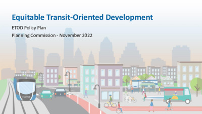
Equitable Transit-Oriented Development ETOD Policy Plan Planning Commission - November 2022 Purpose of the Plan Provide a comprehensive framework to help the Austin community ensure that future development around the Project Connect transit system supports residents of all incomes and backgrounds, especially those who have been disproportionately burdened by past transportation and land use decisions. ETOD Resolution 20210610-093 • Prioritization of equitable outcomes • Categorization of TODs by tiers using context-sensitive criteria • Anti-displacement strategies • Preservation of existing and creation of affordable housing • Creation of market-rate housing • Compact, connected and transit-supportive • Mix of land uses • Codify community benefits What is ETOD? TOD vs. Equitable TOD Why we are going from this.... To this! 4 The ETOD Team 5 Austin’s ETOD Journey Corridor Bond, ASMP, and Project Connect ETOD Study ETOD POLICY PLAN REGULATION AND IMPLEMENTATION Established corridors of Establishes protypes for TOD Recommendations for focus, mode split goals, that reflect Austin’s vision to planning prioritization, and procured funding for equitably share the benefits typologies, policy tools, high-capacity transit of transit investments for and next steps to project delivery. residents of all income levels, implement ETOD in Austin. to zoning. Could be and backgrounds. Adopt ETOD station area plans and code amendments that may include updates expanded to other geographies in the future. WE ARE HERE 2016 - 2020 2021 - 2022 2022 - 2023 2023 - onward 6 ETOD Study • $1.65 million in Federal Transit Administration (FTA) TOD planning grants • 98 stations across all Project Connect lines 1 2 Quantitative analysis of existing conditions within ½ mile of station areas Qualitative data collection through robust community engagement 7 Dashboard – Existing Conditions Dashboard Home Page Multifamily Inventory Total Jobs by Industry Station Tour Interactive Data : • Population • Displacement Risk • Jobs • Urban Fabric • Real Estate • Mobility s c i m a n y D s c i t s i r e t c a r a h c l a i c o S l a c i s y h P 8 8 Engagement Touchpoints Community Presentation Large format meetings to present project milestones CAC Working Group Briefings Monthly meetings, Ongoing guidance throughout project and major milestones Tabling/Intercept Surveys In-person events to target specific neighborhoods or demographics Focus Groups & One-on-ones Guided discussions with groups to identify vision and needs and to build consensus amongst stakeholders …
To: Planning Commission Chair and Commissioners M E M O R A N D U M From: Stevie Greathouse, Housing and Planning Department Date: November1, 2022 Subject: Palm District Plan Adoption This memo provides a brief synopsis of the Palm District Initiative planning process. In 2019, City Council Resolution No. 20190523-029 directed staff to develop a small area plan for the eastern edge of Downtown: the Palm District. The planning process formally kicked off in May 2021, and staff has engaged community through a number of methods, including: • SpeakUpAustin! website (https://www.speakupaustin.org/palmdistrict) • On-line and paper surveys in English and Spanish • A Palm District on-line interactive map • Social Media and E-mail newsletter • Courtesy notification postcard to residents and businesses • June 2021 Virtual Community Visioning Forums • July 2021 American Institute of Architects Virtual Design Workshops • Recordings of all the virtual events to the SpeakUpAustin! website • Ongoing, targeted outreach to Austin’s Mexican American community leaders and longtime residents through interviews and focus groups. To summarize the collective results of all of these engagement efforts, Housing and Planning staff created the Listening Report: What We Heard During the Visioning Phase. Staff next reviewed and analyzed the community input to develop the draft plan’s major themes. Their findings were released in February 2022 in the Draft Vision Framework. In August 2022, a series of four in-person workshops, hosted by the Downtown Austin Alliance (DAA), were held at the Neal Kocurek Memorial Austin Convention Center. A design team from Asakura Robinson led community stakeholders through several scenario planning exercises. Based on those results, through conversations with stakeholders, and a review of previous plan materials, the consultant team developed scenarios based on three different themes: Live, Work, and Play. Staff solicited input on those scenarios through a public survey. The Palm District Plan includes a preferred scenario that aligns with the Vision Framework and is guided by public input. Housing and Planning Department staff are briefing the following boards and commissions about the draft Palm District Plan prior to Council consideration: • Small Area Planning Joint Committee • Environmental Commission • Downtown Commission • Parks Board • Design Commission • Hispanic/Latino Quality of Life Resource Advisory Commission • African American Resource Advisory Commission • Emma S. Barrientos Mexican American Cultural Center Board • Historic Landmark Commission.
PALM DISTRICT PLAN FINAL DRAFT 11/01/2022 TABLE OF CONTENTS EXECUTIVE SUMMARY 1 INTRODUCTION 3 EQUITY FRAMEWORK 4 HISTORY 6 EXISTING CONDITIONS 24 ENGAGEMENT SUMMARY 36 VISION FRAMEWORK 41 KEY OPPORTUNITY SITES 42 DESIRED OUTCOMES 48 SCENARIOS 53 IMPLEMENTATION 65 RECOMMENDATIONS 66 LOOKING FORWARD 75 Appendices A1 The Palm District: Austin’s Cultural Hub - AIA Communities by Design Report A2 Listening Report for Palm District Visioning Phase A3 Palm District Existing Conditions Report A4 Palm District Planning City Council Resolution EXECUTIVE SUMMARY In 2019 the Austin City Council directed staff (Resolution No. 20190523-029) to develop a small area plan for the eastern edge of Downtown: The Palm District. Initial work on the plan began in the latter part of 2019 and early 2020 but was halted by the global COVID-19 pandemic. As 2020 wound down, staff resumed work on the project by developing and refining background documents, designing the public engagement strategy and planning process, conducting preliminary stakeholder outreach, and preparing for the formal kickoff of the planning process in May 2021. Beginning in 2019, Housing and Planning Department Staff convened a City of Austin Palm District Planning Team comprised of representatives from multiple City Departments including Convention Center, Parks and Recreation, Watershed Protection, Transportation, Sustainability, Economic Development, Real Estate, and the Corridor Program Office to provide input and review key deliverables throughout the process. HPD staff also met regularly with representatives from the Downtown Austin Alliance and Waterloo Greenway, as well as Travis County staff, and other key community stakeholders serving as partners in support of the planning process. The Palm District planning process employed a five phase planning process: • Pre-Planning—The project team researched the Palm District in preparation of developing the plan. • Visioning—The project team engaged community and developed a draft vision and outline for the plan. • Active Planning—Staff used the draft vision to identify recommendations and to develop multiple scenarios for the Palm District. As part of their partnership with the City in support of this process, the Downtown Austin Alliance engaged a professional urban design firm, Asakura Robinson, to assist with outreach, focus group facilitation, development of possible future scenarios and a preferred scenario for the draft plan. • Draft Review—Staff developed the draft plan with guidance from city and key stakeholder partners and released the draft for public review and comments. • Plan Adoption—During this time staff reviewed the plan with City of …
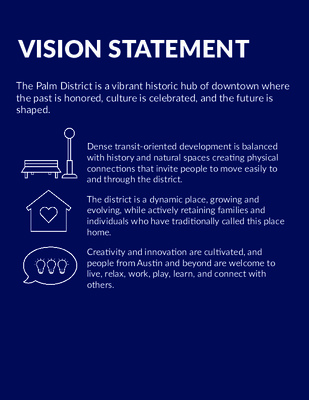
VISION STATEMENT The Palm District is a vibrant historic hub of downtown where the past is honored, culture is celebrated, and the future is shaped. Dense transit-oriented development is balanced with history and natural spaces creating physical connections that invite people to move easily to and through the district. The district is a dynamic place, growing and evolving, while actively retaining families and individuals who have traditionally called this place home. Creativity and innovation are cultivated, and people from Austin and beyond are welcome to live, relax, work, play, learn, and connect with others. 40 Public Review Draft Palm District Plan VISION FRAMEWORK As the district evolves, the plan will guide development and programming to achieve the vision for a vibrant, accessible and successful district. Informed by an understanding of area history, the elements of the vision are inclusive growth, culture, connection and nature. The desired outcomes for each of these elements are outlined in the following sections. 41 Public Review Draft Palm District Plan KEY OPPORTUNITY SITES Key Opportunities identified on the following map series represent sites that are controlled by a variety of public and private entities, and not all sites are under the direct ownership of the City of Austin. Opportunity sites are sites that are likely to serve as key anchors supporting placemaking and helping to achieve desired outcomes in the District over the years ahead. The Vision is intended to provide an aspirational view of how the district could develop over time. Implementation will require a range of actions by the City of Austin and its partners. While Palm Park is currently owned by the City of Austin, the adjacent Palm School is owned by Travis County, and Travis County has been undertaking a process to explore options for this site. For additional information on the Palm School site please visit - https://www.traviscountytx.gov/planning-budget/economic- development-strategic-investments/palm-school. 42 Public Review Draft Palm District Plan Dell Medical School and Dell Seton Medical Center at the University of Texas at Austin 35 Health South Waterloo Park Texas State Capitol INCLUSIVE GROWTH VISION FRAMEWORK Key Opportunities Palm District Parks Waterways To Huston-Tillotson University, Six Square Black Cultural District, and French Legation ARCH APD Headquarters To Plaza Saltillo East Austin 35 To Republic Square Convention Center INCLUSIVE GROWTH PARTNERS & COORDINATION RESOURCES » Housing and Planning » Capital City Innovation » Waterloo Greenway Conservancy » Austin Convention Center » Downtown Austin Alliance …
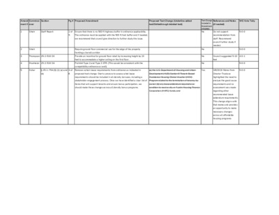
Amend Commissi Section Pg # Proposed Amendment Proposed Text Change (Underline added References and Notes WG Vote Tally ment # oner text/Strikethrough deleted text) (if needed) 1 Shieh Staff Report 2 of Ensure that there is no 500 ft highway buffer in ordinance applicability. Do not support 5-0-0 5 The ordinance must be applied with the 500 ft foot buffer and if needed, we recommend that council give direction to further study the issue. Shieh Require ground floor commercial use for the edge of the property fronting a transit corridor Thompson 25-2-519 D3 Provide an incentive for ground floor retail by increasing height by 10 feet to accommodate a higher ceiling on the first floor. Mushtaler 25-2-519 D4 Prohibit Type 2 and Type 3 STR. (This would be consistent with the compatibility ordinance as well) 2 3 4 5 Azhar § 25-1-754 (G) (1) (a) and 4 of Remove certain lease requirements from ordinance as indicated in (a) the U.S. Department of Housing and Urban Yes 3/6/2019 Memo from 5-0-0 (b) 8 proposed text change. Start a process to assess what lease Development (HUD) Section 8 Tenant-Based Director Truelove requirements should be included in all density bonuses, including a Assistance Housing Choice Voucher (HCV) stakeholder engagement process. Once we have identified a clear list of Program related to the termination of tenancy by items that will support tenants and ensure bonus participation, we owner; (b) any lease addendum required as a should make those changes across all density bonus programs. condition to receive city or Austin Housing Finance assessment was made Corporation (AHFC) funds; and Text Change Included in Amendment (YES/NO) No recommendation from staff. Recommend council further study if needed. No No No Council suggested 5-10 4-0-1 feet 5-0-0 5-0-0 highlighted the need to analyze the good cause requirements and no regarding other recommended lease addendum requirements. This change aligns with that memo and provides an opportunity to make necessary changes across all affordable housing programs 6 Azhar § 25-2-519 (D) (1) 7 of Remove MU standards and replace with standards from the VMU Dimensional and Parking Requirements. Yes Language taken from 4-0-0 8 program. 1. a building that meets the affordability requirements in § 25-1-754 is not subject to certain dimensional standards applicable in the VMU section of code: 25- 2, SUBCHAPTER E, 4.3.3. Standards. E (2) base zoning district. These standards include the and (3) following: a. …
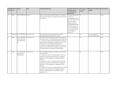
Amend Commissi Section Pg # Proposed Amendment Proposed Text Change Text Change Included References and Notes (if WG Vote Tally ment # oner (Underline added text/Strikethrough deleted text) in Amendment (YES/NO) needed) 1 Shieh § 25-2-769.04 (D) 5 of 14 strike out "two stories" and "three stories" in this section The height limitation for Yes 5-0-0 and remove the reference to stories from all other parts of a structure is: the ordinance. (1) two stories and 35 feet, if the structure is 50 feet or less from a triggering property; (2) three stories and 45 feet, if the structure is more than 50 feet and not more than 100 feet from a triggering property; or 2 3 Thompson § 25-2-769.06 (F) 10 and 11 of 14 Fee in lieu funds must be used within 1 mile of the property and within 0.25 miles of a corridor. Shieh § 25-2-769.06 (F) 4 and 10 of 14 Allow the same compatibility standards on both light rail No No We want housing in 4-0-0 transit supported areas 5-0-0 4 Shieh § 25-2-769.06 (F) 4 and 10 of 14 The compatibility standards for medium corridors should No 5-0-0 (2) and (3), and § 25-2-769.04 (B) (2) (4), and § 25-2- 769.04 (B) (2) and large corridors. This standard should be the following: - a structure can reach allowable height if the structure is located at least 100 feet from a triggering property if it is participating in an affordable housing program. - a structure can reach allowable height if the structure is located at least 200 feet from a triggering property if it is not participating in an affordable housing program. be the following: - a structure can reach a maximum height of 65 ft if the structure is located at least 100 feet from a triggering property if it is participating in an affordable housing - a structure can reach a maximum height of 75 ft if the structure is located at least 150 feet from a triggering property if it is participating in an affordable housing program. program. - a structure can reach the allowable height if the structure is located at least 200 feet from a triggering property, whether it is participating in an affordable housing program or not. 5 Shieh § 25-2-769.04 (C) 5 of 14 Define what is or is not allowed in the 25 foot compatibility No This …
From: To: Cc: Subject: Date: Rivera, Andrew; Rhoades, Wendy Brodie Oaks PUD postponement request at Planning Commission C814-2021-0099 Monday, November 7, 2022 10:40:11 AM *** External Email - Exercise Caution *** Hello, Ms. Rhodes and Mr. Rivera, The Zilker Neighborhood Association requests that the Planning Commission rezoning hearing for the Brodie Oaks PUD, case C814-2021-0099 (items 2, 3, and 4 on the Nov 8 agenda), be postponed to November 15. We'd like to review materials presented at and after the Environmental Commission hearing, including but not limited to the affordable housing agreement and bonus calculations, the terms of the site-specific amendments to the SOS ordinance and the proposed restrictive covenant amendments, the parking calculations, the traffic and transit recommendations, the school impact analysis, the tree plans, the limits on excavations, the electric demand, the water and sewer demand, the fire and EMS demand, and conflicts with Imagine Austin and other planning guidelines. Thank you for your time. Best regards, David Piper, ZNA Secretary CAUTION: This email was received at the City of Austin, from an EXTERNAL source. Please use caution when clicking links or opening attachments. If you believe this to be a malicious and/or phishing email, please forward this email to cybersecurity@austintexas.gov.
November 7, 2022 Via Electronic Delivery Ms. Rosie Truelove Housing and Planning Department City of Austin Street-Jones Building 1000 E. 11th St., Suite 200 Austin, TX 78702 Re: Industrial Blvd and Terry O Lane – Rezoning application for the approximately 5.791-acre property located at 439-511 (odd only) & 515 Industrial Boulevard and 4208 Terry O Lane, Austin, TX 78745, and comprised of Lot 3, OK Addition; Lots 43-50, St. Elmo Heights Sec. 1; and Lots 2-4, Duplex Addition (the "Property") Dear Ms. Truelove: As representatives of the owner of the Property, we respectfully request an indefinite postponement of neighborhood plan amendment application for Industrial Blvd and Terry O Lane, City of Austin case number NPA-2022-0020.01, currently scheduled for a public hearing at the meeting of the Planning Commission on November 8, 2022. Please let me know if you or your team members require additional information or have any questions. Thank you for your time and attention to this project. Sincerely, Leah M. Bojo cc: Wendy Rhoades, Housing and Planning Department (via electronic delivery) Maureen Meredith, Housing and Planning Department (via electronic delivery)
From: To: Cc: Subject: Date: Nathalie Frensley Azhar, Awais - BC; Llanes, Carmen - BC; Hempel, Claire - BC; Shieh, James - BC; Thompson, Jeffrey - BC; Schneider, Robert - BC; Shaw, Todd - BC; Mushtaler, Jennifer - BC; Howard, Patrick - BC; Cox, Grayson - BC; Flores, Yvette - BC; Anderson, Greg - BC; Singh, Arati - BC; Adler, Steve; Alter, Alison; Harper-Madison, Natasha; Fuentes, Vanessa; Renteria, Sabino; Vela, Jose "Chito"; Kitchen, Ann; Kelly, Mackenzie; Pool, Leslie; Ellis, Paige; Tovo, Kathie; Ramirez, Nadia - BC; Kiolbassa, Jolene - BC; King, David - BC; Smith, Hank - BC; Stern, Lonny - BC; Boone, Scott - BC; Woody, Roy - BC; Thompson, Carrie - BC; Denkler, Ann - BC; Acosta, Cesar - BC; Greenberg, Betsy - BC Rivera, Andrew; Cronk, Spencer Resolution calling for LDC Public Hearing Postponement until after Run-off Elections Monday, November 7, 2022 11:58:27 AM *** External Email - Exercise Caution *** Mr. Rivera - Could you please add this to Citizen Comment? Thank you. Dear Commissioners and Council Members, As thousands of Austinites are civically engaged in get-out-the-vote activities, making their vote plans, and working to uphold the administration and integrity of Tuesday’s elections, the Planning Commission has scheduled public hearings starting at 6:00 pm on Election night on several high public interest land development code (LDC) items. This unfairly pits participating in public hearings against participating in Election Day activities. The remedy is to postpone hearing LDC items until after the results of Council elections, including run-offs, are decided. The Planning Commission creates a real, structural impediment to full civic participation in Austin by scheduling LDC items for its Election Day meeting. It effectively forces many Austinites who · are involved in election administration, poll watching, and other activities supporting election integrity to forfeit their right to participate in these public hearings. · made their election plan to vote on Election Day afternoon and evening to have to choose between electoral civic participation and public hearing civic participation. · as community volunteers assist elderly and handicapped voters with transportation to the polls to have to choose between electoral and public hearing participation. Unofficial, unrecorded “Listening Sessions” are no substitute for Austinites to exercise their right to attend a public hearing. Furthermore, run-off elections are likely, which will create more opportunities for the City of Austin to pit our electoral against our public hearing participation. Meetings planned …
From: To: Subject: Date: noreply@coadigital.onbehalfof.austintexas.gov on behalf of City of Austin Rivera, Andrew Proposed changes to zoning compatibility and parking standards Monday, November 7, 2022 12:44:26 PM This message is from Brian Pape. [ Andrew, I would like the following commentary passed along to the members of the Planning Commission before their hearing tomorrow, Election Day, at 6pm regarding the proposed changes to zoning compatibility and parking. I would like to address the commission myself but have already planned to help get people to the polls on Tuesday. Please make certain my comments get to them. Thank you! If I was able to attend the hearing scheduled for 6pm on Election Day, I would say this to all of you: WHEN YOU WEAKEN COMPATIBILITY AND PARKING STANDARDS THAT HAVE BEEN ON THE BOOKS FOR DECADES YOU ARE ILLEGALLY TAKING MONETARY VALUE FROM EXISTING PROPERTY OWNERS (EPO)! How - you might ask? WHEN an adjacent property is permitted to build taller and closer to an EPO and the result takes away privacy and/or permanently alters the look, feel and desirability of the EPO’s home. WHEN a lack of adequate, nearby parking for other properties causes the street an EPO lives on to become constantly crowded with parked cars and congested with vehicular traffic. WHEN a quiet, mostly SFR street or area transforms over several years into a predominantly multi-family street/area with inadequate parking and without adequate infrastructure like sidewalks, street widths, shade, traffic control. WHEN an adjacent property is permitted to build higher and closer to an EPO and permanently changes the shading, natural lighting, rainfall, breeze patterns of the EPO’s landscaping/yard. Ask any non-biased residential real estate professional about each of these “WHENS” and they will tell you that each and every one decreases an existing properties value. In a fully built-out neighborhood/area, you CANNOT CHANGE ZONING WITHOUT TAKING VALUE FROM ONE PROPERTY AND TRANSFERRING IT TO ANOTHER. Do not delude yourself into thinking that you can change existing zoning compatibility and parking standards without changing property values. You are hurting some and enriching others and nobody appointed you to do that! From: To: Subject: Date: noreply@coadigital.onbehalfof.austintexas.gov on behalf of City of Austin Rivera, Andrew Proposed changes to zoning compatibility and parking standards Monday, November 7, 2022 12:44:26 PM This message is from Brian Pape. [ Andrew, I would like the following commentary passed along to the members of the …
PLANNING COMMISSION RECOMMENDATION 20220811-22 Date: November 8, 2022 Subject: Residential in Commercial Code Amendment Motioned By: Commissioner Azhar Recommendation Approve Staff’s recommendation related to amending Title 25 of the City Code to create an affordable housing bonus program and include the following amendments: Seconded By: Commissioner Thompson 1. Ensure that there is no 500 ft highway buffer in ordinance applicability. The ordinance must be applied with the 500 ft foot buffer and if needed, we recommend that council give direction to further study the issue. 2. Require Pedestrian-Oriented Commercial Spaces for a certain portion of the ground floor at the edge of the property fronting a transit corridor, including dimensional requirements and allowable commercial uses from the VMU ordinance. 3. Prohibit Type 2 and Type 3 STR. (This would be consistent with the compatibility ordinance as well) 4. Remove certain lease requirements from ordinance as indicated in proposed text change. Start a process to assess what lease requirements should be included in all density bonuses, including a stakeholder engagement process. Once we have identified a clear list of items that will support tenants and ensure bonus participation, we should make those changes across all density bonus programs. 5. Add advanced design standards from the VMU program. 6. Provide an incentive for ground floor retail by increasing height of the first level by 5 to 10 feet to accommodate a higher ceiling on the first floor. 7. Remove MU standards and replace with standards from the VMU program. Vote : 11-0 For: Chair Shaw, Vice-Chair Hempel and Commissioners Anderson, Azhar, Cox, Flores, Howard, Llanes Pulido, Mushtaler, Shieh and Thompson 1 of 2 Absent: Commissioner Schneider One vacancy on the dais (District 2) Attest: Andrew D. Rivera Planning Commission Staff Liaison 2 of 2
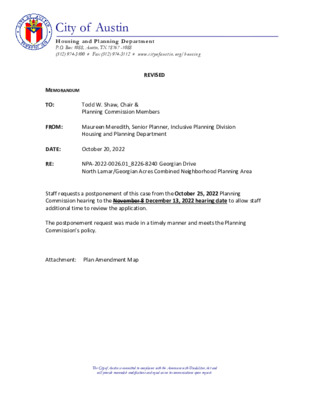
City of Austin Housing and Plannin g Department P.O. Box 1088, Austin, TX 78767 -1088 (512) 974-3100 ♦ Fax (512) 974-3112 ♦ www .c ity o fau s tin .o rg/ h ou s in g MEMORANDUM TO: FROM: DATE: RE: Todd W. Shaw, Chair & Planning Commission Members Maureen Meredith, Senior Planner, Inclusive Planning Division Housing and Planning Department October 18, 2022 NPA-2022-0026.01_8226-8240 Georgian Drive North Lamar/Georgian Acres Combined Neighborhood Planning Area Staff requests a postponement of this case from the October 25, 2022 Planning Commission hearing to the November 8, 2022 hearing date to allow staff additional time to review the application. The postponement request was made in a timely manner and meets the Planning Commission’s policy. Attachment: Plan Amendment Map The City of Austin is committed to compliance with the Americans with Disabilities Act and will provide reasonable modifications and equal access to communications upon request. 1 of 22 The City of Austin is committed to compliance with the Americans with Disabilities Act and will provide reasonable modifications and equal access to communications upon request. 2 of 22
ZONING CHANGE REVIEW SHEET (11,889 square feet) SITE AREA: 0.27 acres DISTRICT: 5 ZONING TO: SF-3-NP CASE: C14-2022-0086 – Merle Single Family ZONING FROM: LO-NP ADDRESS: 4407 Merle Drive PROPERTY OWNER: Tyche Acquisitions Group, LLC (Nicholas Landis) AGENT: Thrower Design, LLC (Victoria Haase) CASE MANAGER: Wendy Rhoades (512-974-7719, wendy.rhoades@austintexas.gov) STAFF RECOMMENDATION: The Staff recommendation is to grant family residence – neighborhood plan (SF-3-NP) combining district zoning. PLANNING COMMISSION ACTION / RECOMMENDATION: October 25, 2022: October 11, 2022: APPROVED A POSTPONEMENT TO OCTOBER 25, 2022 [A. AZHAR; R. SCHNEIDER – 2ND] (7-3) G. COX, Y. FLORES, C. HEMPEL – NAY, J. MUSHTALER – ABSTAIN; C. LLANES PULIDO – ABSENT; ONE VACANCY ON THE COMMISSION CITY COUNCIL ACTION: November 3, 2022: ORDINANCE NUMBER: ISSUES: Staff reviewed the 1968 Use District map and determined that the subject property (and the property to the north and the two similarly situated properties to the west) has had Office district zoning since that time. Based on permit records, there is no evidence that the property has previously been used for office use, and therefore, the single family residence is a legal (nonconforming) use of the property under the existing LO-NP zoning. The –NP combining district was appended to the existing base district upon Council approval of the South Menchaca rezonings in November 2014. The property is within the Residential Core area on the Council-approved Character District Map. 1 of 93 C14-2022-0086 Page 2 CASE MANAGER COMMENTS: The subject rezoning area on Merle Drive consists of a platted lot, contains a single family residence and a detached garage, and is zoned limited office – neighborhood plan (LO-NP) district. There are residences along both sides of Merle Drive (SF-3-NP), as well as office and commercial uses to the north at its intersection with the eastbound frontage road of Ben White Boulevard. Please refer to Exhibits A (Zoning Map) and A-1 (Aerial Exhibit). The Applicant has filed a request to rezone the property to the family residence – neighborhood plan (SF-3-NP) district in order to build either a two-family residence (one single family residence plus an accessory dwelling unit) or a duplex on the property. The Applicant reports there are eight Heritage trees on the property, located towards the street frontage. The proposed rezoning would allow for one duplex residence, or one single family residence plus a second detached unit (a two-family residence, also known as an accessory dwelling …
Planning Commission: October 25, 2022 DATE FILED: June 7, 2022 (Out-of-Cycle) NEIGHBORHOOD PLAN AMENDMENT REVIEW SHEET NEIGHORHOOD PLAN: Heritage Hills/Windsor Hills Combined CASE#: NPA-2022-0028.02 PROJECT NAME: Jonwood Way – 33 Degrees PC DATE: October 25, 2022 ADDRESS/ES: 10600 Jonwood Way DISTRICT AREA: District 1 SITE AREA: 5.48 acres OWNER/APPLICANT: 33D Dessau Road, Austin LLC (Wayne McDonald) AGENT: H.D. Brown Consulting, LLC (Amanda Brown) CASE MANAGER: Maureen Meredith STAFF EMAIL: Maureen.Meredith@austintexas.gov TYPE OF AMENDMENT: Change in Future Land Use Designation PHONE: (512) 974-2695 To: Higher Density Single Family From: Single Family Base District Zoning Change Related Zoning Case: C14-2022-0085 From: SF-2-NP To: SF-6-NP NEIGHBORHOOD PLAN ADOPTION DATE: January 13, 2011 CITY COUNCIL DATE: TBD PLANNING COMMISSION RECOMMENDATION: October 25, 2022 - ACTION: 1 of 334 Planning Commission: October 25, 2022 STAFF RECOMMENDATION: Staff supports the applicant’s request for Higher Density Single Family. BASIS FOR STAFF’S RECOMMENDATION: Staff supports the applicant’s request to change the future land use map from Single Family to Higher Density Single Family land use because the proposed development will increase the housing choices in the neighborhood and the city. The applicant proposes to build approximately nine townhomes. Much of the property will be preserved in the natural state due to development constraints. The plan supports diversity of housing choices in the planning area. Below are sections of the neighborhood plan that supports the applicant’s request. 2 2 of 334 Planning Commission: October 25, 2022 3 LAND USE DESCRIPTIONS EXISTING LAND USE ON THE PROPERTY Single family - Detached or two family residential uses at typical urban and/or suburban densities. Purpose 1. Preserve the land use pattern and future viability of existing neighborhoods; 2. Encourage new infill development that continues existing neighborhood patterns of development; and 3. Protect residential neighborhoods from incompatible business or industry and the loss of existing housing. 3 of 334 Planning Commission: October 25, 2022 Application 1. Existing single‐family areas should generally be designated as single family to preserve established neighborhoods; and 2. May include small lot options (Cottage, Urban Home, Small Lot Single Family) and two‐family residential options (Duplex, Secondary Apartment, Single Family Attached, Two‐Family Residential) in areas considered appropriate for this type of infill development. PROPOSED LAND USE ON THE PROPERTY Higher Density Single Family - Is housing, generally up to 15 units per acre, which includes townhouses and condominiums as well as traditional small‐lot single family. Purpose 1. Provide options for …
ZONING CHANGE REVIEW SHEET DISTRICT: 1 TO: SF-6-NP CASE: C14-2022-0085 10600 Jonwood Way ZONING FROM: SF-2-NP ADDRESS: 10600 Jonwood Way SITE AREA: 5.49 Acres PROPERTY OWNER/APPLICANT: 33D Dessau Rd Austin, LLC AGENT: H. D. Brown Consulting, LLC (Amanda Brown) CASE MANAGER: Heather Chaffin (512-974-2122, heather.chaffin@austintexas.gov) STAFF RECOMMENDATION: Staff supports the Applicant’s request for rezoning to SF-6-NP. For a summary of the basis of staff’s recommendation, see case manager comments on page 2. PLANNING COMMISSION ACTION / RECOMMENDATION: October 25, 2022: CITY COUNCIL ACTION: December 1, 2022: ORDINANCE NUMBER: 1 of 75 C14-2022-0085 2 ISSUES: The southwestern property line of the subject property is located along a segment of Walnut Creek. As a result, the majority of the property is constrained by a creek buffer. While this tract is located at the terminus of Jonwood Way with no other street frontage, the property to the east is under the same ownership and has frontage on Dessau Road. The Applicant has stated their intent to develop the properties as one cohesive development. CASE MANAGER COMMENTS: As stated in the Issues section, the rezoning tract is located at the terminus of Jonwood Way and west of Dessau Road. The property is currently zoned SF-2-NP and is undeveloped. Also stated in the Issues section, the property is constrained by creek buffers; the site is also heavily wooded. North of the property is a single family residential neighborhood with PUD- NP and SF-2-NP. A majority of the properties to the south and west are also zoned SF-2-NP and developed with single family residential uses. Further south are properties zoned SF-3- NP and SF-6-CO-NP that are also developed with residential uses. East of the property is a tract zoned SF-6-CO-NP that is undeveloped and under the same ownership. Conditional overlays on this property were established in 2003 and limited residential and daycare land uses. Further east, across Dessau Road, are SF-2, SF-1 and SF-6-CO-NP that are a mix of undeveloped and residential land uses. Please see Exhibits A and B- Zoning Map and Aerial Exhibit. Staff has received correspondence regarding the rezoning request. Please see Exhibit C- Correspondence. Staff supports the rezoning to SF-6-NP as requested. The majority of the property is constrained by creek buffers and vegetation, making development of single family residential land use under the existing SF-2-NP zoning very limited. SF-6-NP does not have the same subdivision requirements as SF-2-NP and encourages clustered …
Planning Commission: October 25, 2022 NEIGHBORHOOD PLAN AMENDMENT REVIEW SHEET DATE FILED: February 28, 2019 December 14, 2021 March 9, 2021 July 14, 2020 January 28, 2020 August 13, 2019 NEIGHORHOOD PLAN: Bouldin Creek CASE#: NPA-2019-0013.01 PROJECT NAME: Copeland South PC DATE: October 25, 2022 October 11, 2022 September 27, 2022 August 23, 2022 July 26, 2022 February 8, 2022 ADDRESSES: 909, 911, 915, 1001, 1003 S. 2nd Street and 604, 606 Copeland St. DISTRICT AREA: 9 SITE AREA: 0.98 acs OWNER/APPLICANT: SB-Frank South, LLC AGENT: StoryBuilt (Mike Melson) CASE MANAGER: Maureen Meredith STAFF EMAIL: Maureen.Meredith@austintexas.gov TYPE OF AMENDMENT: Change in Future Land Use Designation PHONE: (512) 974-2695 From: Single Family Base District Zoning Change To: Mixed Use Related Zoning Case: C14-2021-0185 From: SF-3-NP NEIGHBORHOOD PLAN ADOPTION DATE: May 23, 2002 To: CS-MU-V-CO-NP 1 1 of 386 Planning Commission: October 25, 2022 ACTION: CITY COUNCIL DATE: TBD PLANNING COMMISSION RECOMMENDATION: October 25, 2022 - October 11, 2022 – Postponed to October 25, 2022 on the consent agenda at the request of staff. [A. Azhar – 1st; C. Hempel – 2nd] Vote: 11-0 [C. Llanes Pulido absent. One vacancy]. September 27, 2022 – Postponed to October 25, 2022 on the consent agenda at the request of staff. [C. Hempel – 1st; G. Cox – 2nd] Vote: 9-0 [J. Mushtaler, R. Schneider, J. Thompson absent. One vacancy]. August 23, 2022 – Postponed to September 27, 2022 on the consent agenda at staff’s request. [J. Thompson – 1st; R. Schneider – 2nd] Vote: 12-0 [S.R. Praxis absent]. July 26, 2022 – Postponed to August 23, 2022 on the consent agenda at staff’s request. [J. Thompson – 2nd; P. Howard – 2nd] Vote: 9-0 [C. Hempel, J. Mushtaler, S.R. Praxis and J. Shieh absent]. February 8, 2022 – Approved the applicant’s request for an indefinite postponement on the consent agenda. [J. Shieh – 1st; G. Cox – 2nd] Vote: 11-0 [J.P. Connolly off the dais. S.R. Praxis absent]. December 14, 2021 – Approved staff’s request for a postponement to February 8, 2022 on the consent agenda. [A. Azhar-1st; R. Schneider – 2nd] Vote: 11-0 [J. Howard off the dais. J. Shieh absent]. July 14, 2020 – Approved the applicant’s request for an indefinite postponement on the consent agenda. [A. Azhar – 1st; J. Shieh- 2nd] Vote: 12-0 [C. Hempel recused due to a conflict of interest (rendered professional services)]. January 28, 2020 – Approved …
ZONING CHANGE REVIEW SHEET DISTRICT: 9 ZONING TO: CS-1-CO-NP CASE: C14-2022-0076 – 3100 Guadalupe St ADDRESS: 3100 Guadalupe Street ZONING FROM: CS-CO-NP TOTAL SITE AREA: 0.075 acres (3,277 square feet) PROPERTY OWNER: Leigh Family Trust (Alice G. Kaspar, Trustee) AGENT: Drenner Group, PC (Amanda Swor) CASE MANAGER: Wendy Rhoades (512-974-7719, wendy.rhoades@austintexas.gov) STAFF RECOMMENDATION: The Staff recommendation is to grant commercial-liquor sales – conditional overlay – neighborhood plan (CS-1-CO-NP) combining district zoning. The Conditional Overlay 1) limits building height to 40 feet, 2) establishes that a drive-in service as an accessory use to a commercial use is a conditional use, 3) prohibits drive-in service as an accessory use to a restaurant (general and limited) use, 4) prohibits Art workshops, Campground, Exterminating services, Kennels, and Vehicle storage, and 5) establishes Automotive repair services, Building maintenance services, Club or lodge, Commercial blood plasma center, Commercial off-street parking, Construction sales and services, Convenience storage, Drop-off recycling collection center, Equipment repair services, Equipment sales, Hospital services (general), Laundry services, Off-site accessory parking, and Service station are conditional uses. For a summary of the basis of Staff’s recommendation, see pages 2-3. PLANNING COMMISSION ACTION / RECOMMENDATION: October 25, 2022: CITY COUNCIL ACTION: To be scheduled ORDINANCE NUMBER: ISSUES: On Wednesday, August 24th, the Applicant had a virtual meeting to discuss the case with representatives of the Heritage Neighborhood Association. 1 of 1210 C14-2022-0076 Page 2 CASE MANAGER COMMENTS: The subject rezoning area contains a 1,000 square foot personal services use within an existing commercial building and an adjacent 2,277 square foot portion of the parking lot extending to East 31st Half Street. The site containing the rezoning area is bounded by East 31st Half Street on the north, Guadalupe Street on the east, and East 31st Street on the south. Driveway access is limited to East 31st Half and East 31st Street. The rezoning area is part of Tract 209 within the West University neighborhood plan approved by Council in September 2004, and has general commercial services – conditional overlay – neighborhood plan CS- CO-NP) district zoning. The conditional overlay establishes a 40-foot height limit, and conditional and prohibited uses, and applies several to other tracts along Guadalupe as well. There are restaurants and personal improvement services uses across West 31st Half to the north, a one-story commercial building, food sales, personal services uses, and single family residences across Guadalupe Street uses to the east (CS-CO-NP; …
PLANNING COMMISSION SITE PLAN CONDITIONAL USE PERMIT REVIEW SHEET PC DATE: 10/25/2022 7310 Union Park Lane, Austin, Texas SP-2021-0143C CASE NUMBER: PROJECT NAME: Easton Park Mixed Use ADDRESS: APPLICANT: AGENT: First Hartford Corporation 149 Colonial Road Manchester, CT 06042 (860) 712-4490 Attn: Jonathan Bellock WGI 2021 E. 5th Street, Ste. 200 Austin, Texas 78702 (512) 669-5560 Attn: Siri Soth William Cannon Associates 149 Colonial Road Manchester CT 06042 (860) 712-4490 Attn: Jonathan Bellock Cottonmouth Creek (Suburban) CASE MANAGER: Randall Rouda, (512) 974-3338 or Randall.rouda@austintexas.gov WATERSHED: PROJECT DESCRIPTION: The applicant proposes to develop an 8.55acre parcel in the Pilot Knob PUD with a mixed commercial development consisting of four buildings to be used as a drive through restaurant, a car wash, a multi-tenant commercial building and a convenience retail building, with associated parking, drainage, water quality, utility, and sidewalk improvements. Within the Pilot Knob PUD, the proposed Car Was is permitted with a Conditional Use Permit. SUMMARY STAFF RECOMMENDATION: Staff recommends approval of the Conditional Use Permit with Conditions of Approval as needed to ensure that the Site Plan will comply with all requirements of the Land Development Code. SUMMARY STAFF COMMENT ON SITE PLAN: Comments pending completion of the current update review. PROJECT INFORMATION: SITE AREA ZONING PROPOSED USE PROPOSED IMPERVIOUS COVER PROPOSED BUILDING COVERAGE 29,201 sq.ft., 7.84% PROPOSED BUILDING HEIGHT PROPOSED F.A.R PROPOSED ACCESS 8.55 Acres PUD (Pilot Knob) Various Commercial 4.32 acres, 51% 1 story, 30 feet 0.079-1:1 Union Park Lane, Dunant Way, William Cannon Dr. 186 automobile, 25 bicycle PROPOSED PARKING 1 of 611 SPC-2021-0143C NEIGHBORHOOD ORGANIZATIONS: Austin Lost and Found Pets Austin Neighborhoods Council Del Valle Community Coalition Del Valle Independent School District Dove Springs Proud Easton Park Master Community Easton Park Mixed Use Page 2 Friends of Austin Neighborhoods Go Austin / Vamos Austin 78774 Homeless Neighborhood Association Onion Creek Homeowners Assoc., Sierra Club, Austin Regional Group CONDITIONAL USE PERMIT REVIEW AND EVALUATION CRITERIA The following evaluation is included to provide staff position on each point of the conditional use permit criteria. Section 25-5-145 of the Land Development Code states: “The Commission shall determine whether the proposed development or use of a conditional use site plan complies with the requirements of this section. Note that Staff Analysis is subject to revision pending completion of the Site Plan Review which is currently underway. A conditional use site plan must: 1. Comply with the requirements of this …
FINAL PLATAUSTIN WATER NOTESUTILITY PLAN & PROFILESSHEET 21SHEET 22SHEET 23SHEET 24, 5, 71 of 712 PROMONTORY POINT DRIVE SEQUENCE OF CONSTRUCTION SCALE: 1" = 30' LEGEND PHASE 2 PROPOSED BUILDING 2 PHASE 2 8,000 S.F. FF=628.0 SLAB ON GRADE PHASE 1 E N A L O G A B E N N I W E 2 S A H P PHASE 1 DETENTION POND PHASE 1 GS GS GS GS MECH PAD 20'x76' S T O R M S E W E R P H A S E 1 OUTDOOR DECK PHASE 1 3,580 S.F. P H A S E 1 S T O R M S E W E R PROPOSED BUILDING 3 PHASE 3 2 STORY 13,750 S.F. PHASE 3 PROPOSED BUILDING 1 PHASE 1 33,628 S.F. FF=632.5 SLAB ON GRADE BASEMENT STORAGE PHASE 1 5,000 S.F. PHASE 1 CO2 A D G MC ESIGN ROUP ENGINEERING AND CONSTRUCTION CONSULTANTS P.O. BOX 341555 AUSTIN, TEXAS 78734 512-385-2911 512-385-5400 FAX TEXAS REGISTERED ENGINEERING FIRM F-1708 n g i s e D r e w o r h T 6 5 4 4 - 6 7 4 ) 2 1 5 ( 4 0 7 8 7 S A X E T , I N T S U A 7 5 9 1 4 X O B . O P . S R E N N A L P D N A L y n a n i d e s u r o d e h s i l b u p , d e t u b i r t s i d , d e c u d o r p e r e b t o n t s u m d n a . c n I , p u o r G n g i s e D . c n I , p u o r G n g i s e D C M A f o t n e s n o c n e t t i r w r o i r p e h t f o e c n e s b a e h t n i r e n n a m r e h t o C M A f o y t r e p o r p l a i t n e d i f n o c d n a …
SUBDIVISION REVIEW SHEET CASE NO.: C8-2021-0152 COMMISSION DATE: October 25, 2022 SUBDIVISION NAME: Pinnacle at Wildhorse Ranch Preliminary Plan ADDRESS: 12000 Blue Bluff Rd APPLICANT: Texas WH200 LP AGENT: Kimley-Horn and Associates (Kevin Burks) ZONING: Wildhorse Ranch PUD NEIGHBORHOOD PLAN: Wildhorse Ranch PUD AREA: 60.06 acres COUNTY: Travis LOTS: 57 DISTRICT: 1 WATERSHED: Gilleland Creek JURISDICTION: Full Purpose SIDEWALKS: Sidewalks will be constructed along all internal streets and the subdivision side of Blue Bluff Road. VARIANCES: Variances from LDC § 25-8-341, to allow cut to 15 feet, and LDC § 25-8-342, to allow fill to 15 feet. DEPARTMENT COMMENTS: The request is for the approval of Pinnacle at Wildhorse Ranch Preliminary Plan, consisting of 57 lots on 60.06 acres. The variances from LDC § 25-8-341, to allow cut to 15 feet, and LDC § 25-8-342, to allow fill to 15 feet, were approved by the Zoning and Platting Commission on August 16, 2022. However, the preliminary plan was disapproved at that time. The recent update for this preliminary plan now complies with the criteria for approval in LDC 25-4- 84(B) and staff recommends approval. STAFF RECOMMENDATION: The staff recommends approval of the Preliminary Plan. This Preliminary Plan meets all applicable State and City of Austin LDC requirements. CASE MANAGER: Juan Enriquez EMAIL: juan.enriquez@austintexas.gov ATTACHMENTS Exhibit A: Vicinity Map Exhibit B: Proposed Preliminary Plan Exhibit C: Master Comment Report PHONE: 512-974-2767 1 of 613 U S R O U T E 2 9 0 BLUE BLUFF ROAD T E X A S S T A T E H I G H W A Y 1 3 0 LOCATION MAP SCALE: 1" = 2,000' THE PINNACLE AT WILDHORSE RANCH AUSTIN, TEXAS MARCH 2021 10814 Jollyville Road Campus IV, Suite 300 Austin, Texas 78759 737-471-0157 State of Texas Registration No. F-928 NOTE: THIS PLAN IS CONCEPTUAL IN NATURE AND HAS BEEN PRODUCED WITHOUT THE BENEFIT OF A SURVEY, TOPOGRAPHY, UTILITIES, CONTACT WITH THE CITY, ETC. 2 of 613 PRELIMINARY PLAN FOR PINNACLE AT WILDHORSE RANCH CITY OF AUSTIN, TRAVIS COUNTY, TEXAS E U S 2 9 0 S V R D E B OLD HWY 20 E P A R M E R L A N E CITY LIMITS LINE CITY OF MANOR BLUE BLUFF ROAD N S H 1 3 0 N B PROJECT LOCATION CITY OF AUSTIN VICINITY MAP SCALE: 1" = 2,000' MAPSCO GRID #559A, #559B #559E & #559F DRAINAGE …
SUBDIVISION REVIEW SHEET COUNTY: Travis LOT(S): 2 total lots (AJ Zorn) P.C. DATE: October 25, 2022 JURISDICTION: Limited Purpose AGENT: Carlson, Brigance & Doering, Inc. (Charles Brigance) CASE NO.: C8J-2022-0177.1A SUBDIVISION NAME: Easton Park Section 4B-East Phase 1 Final Plat AREA: 13.769 acres OWNER/APPLICANT: Carma Easton, LLC ADDRESS OF SUBDIVISION: William Cannon Drive GRIDS: L12 WATERSHED: N. Fork Dry Creek EXISTING ZONING: Planned Unit Development (PUD) MUD PLAN: Pilot Knob MUD PROPOSED LAND USE: 2 lots -1 mixed residential per PUD, open space/greenbelt SIDEWALKS: Sidewalks will be provided along all internal streets and the boundary street. DEPARTMENT COMMENTS: The request is for approval of the Easton Park Section 4B- East Phase 1 Final Plat. This is a final plat out of an approved preliminary plan. The final plat is composed of 2 lots on 13.769 acres. There will 1 mixed residential lot and 1 open space/greenbelt lot, and approximately 483’ linear feet of ROW for Cota Vista Drive. Water and wastewater will be provided by the City of Austin. Staff recommends approval of the final plat, subject to the conditions listed in the attached comment report. After the conditions are met, the plan will comply with LDC 30-2-84. The conditions include remove or update notes, update engineer’s report and drainage information, etc. These are administrative actions that require no discretionary review. An application that has been approved with conditions may be updated to address those conditions until the application expires and the plan does not need to be heard before the Commission again. VARIANCES: None STAFF RECOMMENDATION: Staff recommends approval of the Final Plat, subject to the conditions listed in the comment report dated October 20, 2022 and attached as Exhibit C. CASE MANAGER: Sue Welch, Travis County TNR Email address: Sue.Welch@traviscountytx.gov Exhibit A: Easton Park 4BE Ph 1 Final Plat Exhibit B: Easton Park 4BE Ph 1 Location Map Exhibit C: Easton Park 4BE Ph 1 Report PHONE: (512) 854-7637 1 of 1314 COLTO N-BLUFF Y A W K R A S P L L A Y F E N McKIN T H A X T O N W M. CAN N O N DR. SPRIN GS F I N I A L D R I V E SITE SLAUGHTER LANE N O T X A H T C B D Carlson, Brigance & Doering, Inc. FIRM ID #F3791 REG. # 10024900 Civil Engineering Surveying 5501 West William Cannon …
Frequently Asked Questions This FAQ sheet is intended to provide a brief orientation to the Historic Design Standards. Please contact preservation@austintexas.gov if you have further questions. 1 Why were the Historic Design Standards I own a property in a locally designated historic developed? Don’t we already have standards for district. How will the Historic Design Standards 3 historic properties? affect me? The Historic Design Standards were developed to clarify existing standards for historic landmarks and National Register districts. They will also make the historic district application process easier and more equitable for new districts. The Historic Design Standards will not affect previously agreed-upon design standards for existing historic districts. They do align with existing district design standards and may be adopted by property owners within each district if desired. The Secretary of the Interior’s Standards for Rehabilitation form the foundation of preservation practice in the United States and are used in Austin to evaluate proposed changes to historic landmarks and in National Register districts. However, these very general standards can be hard to interpret when planning and evaluating specific projects. The Historic Design Standards clarify them with more specific good practices and illustrations. Right now, community members compiling a historic district application must hire a consultant or learn how to develop their own design standards. Then multiple rounds of review are required with other property owners and City staff. This adds time and cost to the application process—and results in design standards that are nearly identical to those for other districts. The Historic Design Standards will provide a consistent, predictable set of standards for all areas considering historic district designation. I own a historic landmark. How will the Historic 2 Design Standards affect me? If adopted by City Council, the Historic Design Standards will clarify existing standards for exterior changes to historic landmarks, as well as new construction on landmarked properties. The Historic Design Standards are based on the standards that City staff and the Historic Landmark Commission already use to evaluate projects. However, they are clearer, more specific, and easier to use. No process changes are proposed. 4 I own a property in a National Register district. How will the Historic Design Standards affect me? If adopted by City Council, the Historic Design Standards will clarify existing guidelines for National Register district properties. The Historic Design Standards are based on the standards that City staff and the Historic Landmark …
PLANNING COMMISSION AGENDA Tuesday, October 25, 2022 The Planning Commission will convene at 6:00 PM on Tuesday, October 25, 2022 at City Hall, Council Chambers 1001 301 W. Second Street, Austin, TX. Some members of the Planning Commission may be participating by videoconference. The meeting may be viewed online at: http://www.austintexas.gov/page/watch-atxn-live Greg Anderson Awais Azhar Grayson Cox Yvette Flores – Secretary Claire Hempel – Vice-Chair Patrick Howard Jennifer Mushtaler Carmen Llanes Pulido Robert Schneider Todd Shaw – Chair James Shieh – Parliamentarian Jeffrey Thompson District 2 - Vacant Ex-Officio Members Arati Singh – AISD Board of Trustees Jessica Cohen – Chair of Board of Adjustment Spencer Cronk - City Manager Richard Mendoza - Director of Public Works EXECUTIVE SESSION (No public discussion) The Planning Commission will announce it will go into Executive Session, if necessary, pursuant to Chapter 551 of the Texas Government Code, to receive advice from Legal Counsel on matters specifically listed on this agenda. The Commission may not conduct a closed meeting without the approval of the city attorney. Private Consultation with Attorney – Section 551.071 Attorney: Steven Maddoux, 512-974-6080 Commission Liaison: Andrew Rivera, 512-974-6508 PUBLIC COMMUNICATION The first four (4) speakers signed up prior to the commencement of the meeting will each be allowed a three-minute allotment to address their concerns regarding items not posted on the agenda. APPROVAL OF MINUTES 1. Approve the minutes of October 11, 2022. PUBLIC HEARINGS 2. Plan Amendment: Location: Owner/Applicant: Agent: Request: Staff Rec.: Staff: Postponement Request NPA-2022-0026.01 - 8226-8240 Georgian Drive; District 4 8226 - 8240 Georgian Drive, Little Walnut Creek Watershed; North Lamar / Georgian Acres NP Area Quality Foundation Repair (Simon Wallace) Thrower Design (Victoria Haase and Ron Thrower) From Neighborhood Commerical to Mixed Use land use Pending Maureen Meredith, 512-974-2695, maureen.meredith@austintexas.gov Housing and Planning Department Staff postponement to December 13, 2022. 3. Rezoning: Location: Owner/Applicant: Agent: Request: Staff Rec.: Staff: C14-2022-0086 - Merle Single Family; District 5 4407 Merle Drive; Williamson Creek Watershed; South Austin Combined (South Manchaca) NP Area Tyche Acquisitions Group, LLC (Nicholas Landis) Thrower Design, LLC (Victoria Haase) LO-NP to SF-3-NP Recommended Wendy Rhoades, 512-974-7719, wendy.rhoades@austintexas.gov Housing and Planning Department 4. Plan Amendment: Location: NPA-2022-0028.02 - Jonwood Way - 33 Degrees; District 1 10600 Jonwood Way, Walnut Creek Watershed; Heritage Hills/Windsor Hills NP Area Owner/Applicant: Wayne McDonald - 33D Dessau Road, Austin, LLC Kimley-Horn (Amanda Brown) Agent: From Single Family to Higher Density …
City of Austin Housing and Plannin g Department P.O. Box 1088, Austin, TX 78767 -1088 (512) 974-3100 ♦ Fax (512) 974-3112 ♦ www .c ity o fau s tin .o rg/ h ou s in g REVISED Todd W. Shaw, Chair & Planning Commission Members MEMORANDUM TO: FROM: DATE: RE: Maureen Meredith, Senior Planner, Inclusive Planning Division Housing and Planning Department October 20, 2022 NPA-2022-0026.01_8226-8240 Georgian Drive North Lamar/Georgian Acres Combined Neighborhood Planning Area Staff requests a postponement of this case from the October 25, 2022 Planning Commission hearing to the November 8 December 13, 2022 hearing date to allow staff additional time to review the application. The postponement request was made in a timely manner and meets the Planning Commission’s policy. Attachment: Plan Amendment Map The City of Austin is committed to compliance with the Americans with Disabilities Act and will provide reasonable modifications and equal access to communications upon request. The City of Austin is committed to compliance with the Americans with Disabilities Act and will provide reasonable modifications and equal access to communications upon request.
Heritage Hills/Windsor Hills Neighborhood Plan Contact Team Austin, Texas 78753 October 20, 2022 Hi Maureen, This is a letter concerning NPA and zoning case (NPA-2022-0028.02 and C14-2022-008) and the property on Jonwood Way. There are two neighborhoods that will be directly impacted. From meetings I attended, there are concerns about the rezoning. • Both neighborhoods would prefer to see fewer houses in the current greenspace. Currently this • • greenspace hosts an abundance of wildlife, many resettled from the developments on the east side of Dessau. Parkland dedication. Everyone appreciates the parkland dedication of this parcel prior to zoning approval. However, we the neighbors would like this land kept as a wild place, with no park improvements. There is a lack of visibility for the entire development. (Figure 1) This zoning request is being made so that this lot can be included in the 30-unit build planned for the adjacent lot. We have not been presented with an overall plan, and have several related requests/concerns: o Can we have confirmation that construction will not cause future flooding to neighbors adjacent to the property? o The developers promised a vegetative barrier will be installed between the properties on Jonwood and the new housing development. We would like commitment on that. o The developers promised to build the primary entrance to the site on Dessau, particularly during the construction phase. We would like commitment on that. o Could the parkland dedication be extended to the adjacent property as well to protect the entire creek (Figure 2). We appreciate that the developers worked hard to meet with the neighborhood leaders. However, it would be good to understand how the entire planned development will impact the neighborhood. Please feel free to reach out to me if you have any questions. Thank you, Gina Rosenthal HHWH Contact Team Member 9405 Dallum Drive 512.850.9769 Figure 1: Adjacent Parcel Figure 2: Adjacent Parcel Parkland Request