************************************************************************ MEMORANDUM TO: Todd Shaw, Chair Planning Commission Members FROM: Heather Chaffin, Senior Planner Housing and Planning Department DATE: November 15, 2022 RE: Springdale Commercial -- C14-2022-0015 Springdale Commercial (Tract 2) Amended – C14-2022-0070 Postponement Request by Staff ************************************************************************ Staff requests a postponement of these related cases from the November 15, 2022, Planning Commission agenda to the December 13, 2022, commission agenda. Additional information is being gathered regarding these properties. 1 of 115
************************************************************************ MEMORANDUM TO: Todd Shaw, Chair Planning Commission Members FROM: Heather Chaffin, Senior Planner Housing and Planning Department DATE: November 15, 2022 RE: Springdale Commercial -- C14-2022-0015 Springdale Commercial (Tract 2) Amended – C14-2022-0070 Postponement Request by Staff ************************************************************************ Staff requests a postponement of these related cases from the November 15, 2022, Planning Commission agenda to the December 13, 2022, commission agenda. Additional information is being gathered regarding these properties. 1 of 116
ZONING CHANGE REVIEW SHEET CASE: C14-2020-0120 (5003 Burnet, LLC) DISTRICT: 7 ADDRESS: 5003 Burnet Road ZONING FROM: CS-MU-V-CO-NP TO: CS-1-MU-V-CO-NP SITE AREA: 0.267 acres PROPERTY OWNER: 5003 Burnet, LLC (Najib Wehbe) AGENT: Hector Consulting (Hector Avila) CASE MANAGER: Sherri Sirwaitis (512-974-3057, sherri.sirwaitis@austintexas.gov) STAFF RECOMMEDATION: Staff recommends CS-1-MU-V-CO-NP, Commercial-Liquor Sales-Mixed Use-Vertical Mixed Use Building-Conditional Overlay, Neighborhood Plan Combining District. The conditional overlay will maintain the conditions from the Brentwood Neighborhood Plan rezoning ordinance (Ordinance No. 040513-33A) for Tract 50b to prohibit the following uses: Agricultural sales and services, Campground, Commercial blood plasma center, Drop-off recycling collection facility, Equipment repair services, Equipment sales, Kennels, Outdoor entertainment, Outdoor sports and recreation and Vehicle Storage. In addition, Construction sales and services use is a conditional use. The staff also recommends prohibiting the Cocktail lounge use on the property. PLANNING COMMISSION ACTION / RECOMMENDATION: October 11, 2022: Postponed to November 15, 2022 at the applicant's request by consent (11-0, C. Llanes-Pulido-absent); A. Azhar-1st, C. Hempel-2nd. November 15, 2022 CITY COUNCIL ACTION: ORDINANCE NUMBER: 1 of 4217 C14-2022-0120 ISSUES: N/A CASE MANAGER COMMENTS: 2 The property in question contains a vacant 3,000 sq. ft. structure on a platted lot, with a billboard sign, that fronts onto Burnet Road. The lot to the north is developed with commercial uses (Eye Physicians of Austin, Korman Jewelry, Citizen Eatery). The tract to the south contains is a vacant restaurant use (formerly Sonic Drive In). To the east, there is a parking area and single-family residences. The lots to the west, across Burnet Road are developed with a monument retail sales use, an office use (David Manning Architecture), a restaurant use (500 Burnet Food) and a retail sales use (Wilson Jewelers). In this rezoning request, the applicant is asking for CS-1-MU-V-CO-NP zoning to redevelop the existing structure with a liquor store use. The staff recommends CS-1-MU-V-CO-NP, Commercial-Liquor Sales-Mixed Use-Vertical Mixed Use Building-Conditional Overlay, Neighborhood Plan Combining District, zoning. The site meets intent of the CS-1 base district as it is takes access to Burnet Road, a Level 3 arterial roadway. The proposed zoning is compatible with surrounding zoning patterns as there is CS-MU-V-CO-NP and GR-MU-V-CO-NP zoning to the north and south, GO-MU- CO-NP zoning to the east and CS-V zoning, across Burnet Road to the west. The property is surrounded by commercial and office uses and is located within the Burnet Road Activity Corridor as identified on the Growth Concept …
ZONING CHANGE REVIEW SHEET CC Date: December 1, 2022 CASE NUMBER: C14H-2022-0139 HLC DATE: November 2, 2022 PC DATE: November 15, 2022 APPLICANT: J. Pieratt (owner-initiated) HISTORIC NAME: Felts-Moss House WATERSHED: Shoal Creek ADDRESS OF PROPOSED ZONING CHANGE: 2311 Woodlawn Blvd. ZONING CHANGE: SF-3 to SF-3-H COUNCIL DISTRICT: 10 STAFF RECOMMENDATION: Staff recommends the proposed zoning change from family residence (SF-3) to family residence-historic landmark (TOD-H-NP) combining district zoning. QUALIFICATIONS FOR LANDMARK DESIGNATION: Architecture, historical associations, and historical associations under Criteria Consideration G of the National Register of Historic Places as defined in Land Development Code § 25-2- 352(A)(1). HISTORIC LANDMARK COMMISSION ACTION: Grant the applicant’s request to rezone the property from family residence (SF-3) to family residence-historic landmark (TOD-H-NP) combining district zoning (11-0). PLANNING COMMISSION ACTION: CITY COUNCIL ACTION: CASE MANAGER: Kalan Contreras NEIGHBORHOOD ORGANIZATIONS: Austin Independent School District, Austin Lost and Found Pets, Austin Neighborhoods Council, Friends of Austin Neighborhoods, Homeless Neighborhood Association, Neighborhood Empowerment Foundation, Old Enfield Homeowners Assn., Pease Neighborhood Association, Preservation Austin, SELTexas, Save Historic Muny District, Shoal Creek Conservancy, Sierra Club, Austin Regional Group DEPARTMENT COMMENTS: N/a BASIS FOR RECOMMENDATION: § 25-2-352(3)(c)(i) Architecture. The property embodies the distinguishing characteristics of a recognized architectural style, type, or method of construction; exemplifies technological innovation in design or construction; displays high artistic value in representing ethnic or folk art, architecture, or construction; represents a rare example of an architectural style in the city; serves as an outstanding example of the work of an architect, builder, or artisan who significantly contributed to the development of the city, state, or nation; possesses cultural, historical, or architectural value as a particularly fine or unique example of a utilitarian or vernacular structure; or represents an architectural curiosity or one-of-a-kind building. PHONE: 512-974-2727 The 1938 house is a good example of Georgian Revival architecture constructed by central Texas architect Lee M. Smith. It was the first building constructed on Woodlawn Boulevard. According to the application: In 1938, Lee M. Smith's architectural office was at 311 W. 7th St. Smith first appears in the Austin City Directory of 1935 as an architect working for Van C. Kelly Lumber Company, then in the Austin City Directory of 1937 as an architect with Calcasieu Lumber Company, which had its own stable of building designers, most of whom were not certified architects (registration of architects did not begin until the 1930s). He appears to have had …
1183A45353535118329045453603603607135351304535183183183130Loop 1PalmerLaneIH 35Loop 360RR 2222Toll SH 45FM 969US 183US 290US 71RM 620NLAMARBLVDW6THSTANDERSONMILLRDSPRINGDALERDWBRAKERLNW 38TH STS1STSTDESSAURDBRODIE LNERIVERSIDEDRSLAMARBLVDWWILLIAMCANNONDRE7THSTWSLAUGHTERLNCAMERONRDBURNETRDMC NEIL DRSCONGRESSAVETODD LNAustinFull and Limited Purpose City of Austin BoundariesLarge CorridorLight RailMedium Corridor Name Segment Category Corridor Type Center Ridge Drive Between North I.H.‐35 Frontage Road and Center Line Pass Project Connect Light Rail North Lamar Boulevard 3 West Guadalupe Street Between West Guadalupe Street and the south curb of West H Between Guadalupe Street and North Lamar Boulevard d L Project Connect Light Rail Project Connect Light Rail Guadalupe Street Between 45th Street and West Cesar Chavez Street Project Connect Light Rail 5 West Riverside Drive Between South 1st Street and South Congress Avenue Project Connect Light Rail South Congress Avenue Between Riverside Drive and Ralph Ablanedo Drive Project Connect Light Rail East State Highway 71 Frontage Roads Between Spirit of Texas Drive and South U.S. Highway 183 Project Connect Light Rail Between South U.S. Highway 183 and South Congress Avenue Project Connect Light Rail Between its terminus south of Cesar Chavez and East 4th Street Project Connect Light Rail Between Trinity Street and Guadalupe Street Project Connect Light Rail 1 2 4 6 7 8 9 Riverside Drive Trinity Street 10 11 4th Street IH‐35 Between City Limit & City Limit 12 MOPAC EXPRESSWAY (LOOP 1) 13 US 183/183 A (RESEARCH Between SH 45 N & SH 45 S Between City Limit & City Limit BLVD/ANDERSON LN/ED BLUESTEIN 14 W US 290 Between City Limit & CAPITAL OF TEXAS HIGHWAY (LOOP 360) Level 5 15 W SH 71 Between City Limit & W US 290 16 BEN WHITE BLVD (US 290/SH 71) Between CAPITAL OF TEXAS HIGHWAY (LOOP 360) & US 183 Level 5 Level 5 Level 5 Level 5 Level 5 Level 5 Level 5 Level 5 Level 5 Level 5 Level 5 Larger Corridor Larger Corridor Larger Corridor Larger Corridor Larger Corridor Larger Corridor Larger Corridor Larger Corridor Larger Corridor Larger Corridor Larger Corridor Larger Corridor Between AIRPORT BLVD & City Limit Between US 183 & City Limit Between US 183 & City Limit SH 45 S SH 130 20 21 22 CAPITAL OF TEXAS HIGHWAY (LOOP Between MOPAC EXPRESSWAY (LOOP 1) & FM 1626 Between City Limit & City Limit Between US 183 & BEN WHITE BLVD (US 290/SH 71) 17 18 19 E US 290 E SH 71 SH 45 N 360) 11/9/22 DRAFT - SUBJECT TO CHANGE 23 …
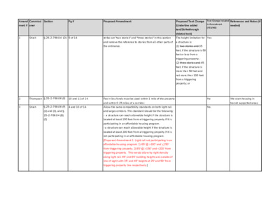
Amend Commissi Section Pg # Proposed Amendment Proposed Text Change Text Change Included References and Notes (if WG Vote Tally ment # oner (Underline added text/Strikethrough deleted text) in Amendment (YES/NO) needed) 1 Shieh § 25-2-769.04 (D) 5 of 14 strike out "two stories" and "three stories" in this section The height limitation for Yes 5-0-0 and remove the reference to stories from all other parts of a structure is: the ordinance. (1) two stories and 35 feet, if the structure is 50 feet or less from a triggering property; (2) three stories and 45 feet, if the structure is more than 50 feet and not more than 100 feet from a triggering property; or 2 3 Thompson § 25-2-769.06 (F) 10 and 11 of 14 Fee in lieu funds must be used within 1 mile of the property and within 0.25 miles of a corridor. Shieh § 25-2-769.06 (F) 4 and 10 of 14 Allow the same compatibility standards on both light rail No No We want housing in 4-0-0 transit supported areas 5-0-0 4 Shieh § 25-2-769.06 (F) 4 and 10 of 14 The compatibility standards for medium corridors should No 5-0-0 (2) and (3), and § 25-2-769.04 (B) (2) (4), and § 25-2- 769.04 (B) (2) and large corridors. This standard should be the following: - a structure can reach allowable height if the structure is located at least 100 feet from a triggering property if it is participating in an affordable housing program. - a structure can reach allowable height if the structure is located at least 200 feet from a triggering property if it is not participating in an affordable housing program. be the following: - a structure can reach a maximum height of 65 ft if the structure is located at least 100 feet from a triggering property if it is participating in an affordable housing - a structure can reach a maximum height of 75 ft if the structure is located at least 150 feet from a triggering property if it is participating in an affordable housing program. program. - a structure can reach the allowable height if the structure is located at least 200 feet from a triggering property, whether it is participating in an affordable housing program or not. 5 Shieh § 25-2-769.04 (C) 5 of 14 Define what is or is not allowed in the 25 foot compatibility No This …
To: Planning Commission Chair and Commissioners M E M O R A N D U M From: Stevie Greathouse, Housing and Planning Department Date: November1, 2022 Subject: Palm District Plan Adoption This memo provides a brief synopsis of the Palm District Initiative planning process. In 2019, City Council Resolution No. 20190523-029 directed staff to develop a small area plan for the eastern edge of Downtown: the Palm District. The planning process formally kicked off in May 2021, and staff has engaged community through a number of methods, including: • SpeakUpAustin! website (https://www.speakupaustin.org/palmdistrict) • On-line and paper surveys in English and Spanish • A Palm District on-line interactive map • Social Media and E-mail newsletter • Courtesy notification postcard to residents and businesses • June 2021 Virtual Community Visioning Forums • July 2021 American Institute of Architects Virtual Design Workshops • Recordings of all the virtual events to the SpeakUpAustin! website • Ongoing, targeted outreach to Austin’s Mexican American community leaders and longtime residents through interviews and focus groups. To summarize the collective results of all of these engagement efforts, Housing and Planning staff created the Listening Report: What We Heard During the Visioning Phase. Staff next reviewed and analyzed the community input to develop the draft plan’s major themes. Their findings were released in February 2022 in the Draft Vision Framework. In August 2022, a series of four in-person workshops, hosted by the Downtown Austin Alliance (DAA), were held at the Neal Kocurek Memorial Austin Convention Center. A design team from Asakura Robinson led community stakeholders through several scenario planning exercises. Based on those results, through conversations with stakeholders, and a review of previous plan materials, the consultant team developed scenarios based on three different themes: Live, Work, and Play. Staff solicited input on those scenarios through a public survey. The Palm District Plan includes a preferred scenario that aligns with the Vision Framework and is guided by public input. Housing and Planning Department staff are briefing the following boards and commissions about the draft Palm District Plan prior to Council consideration: • Small Area Planning Joint Committee • Environmental Commission • Downtown Commission • Parks Board • Design Commission • Hispanic/Latino Quality of Life Resource Advisory Commission • African American Resource Advisory Commission • Emma S. Barrientos Mexican American Cultural Center Board • Historic Landmark Commission.
PALM DISTRICT PLAN FINAL DRAFT 11/01/2022 TABLE OF CONTENTS EXECUTIVE SUMMARY 1 INTRODUCTION 3 EQUITY FRAMEWORK 4 HISTORY 6 EXISTING CONDITIONS 24 ENGAGEMENT SUMMARY 36 VISION FRAMEWORK 41 KEY OPPORTUNITY SITES 42 DESIRED OUTCOMES 48 SCENARIOS 53 IMPLEMENTATION 65 RECOMMENDATIONS 66 LOOKING FORWARD 75 Appendices A1 The Palm District: Austin’s Cultural Hub - AIA Communities by Design Report A2 Listening Report for Palm District Visioning Phase A3 Palm District Existing Conditions Report A4 Palm District Planning City Council Resolution EXECUTIVE SUMMARY In 2019 the Austin City Council directed staff (Resolution No. 20190523-029) to develop a small area plan for the eastern edge of Downtown: The Palm District. Initial work on the plan began in the latter part of 2019 and early 2020 but was halted by the global COVID-19 pandemic. As 2020 wound down, staff resumed work on the project by developing and refining background documents, designing the public engagement strategy and planning process, conducting preliminary stakeholder outreach, and preparing for the formal kickoff of the planning process in May 2021. Beginning in 2019, Housing and Planning Department Staff convened a City of Austin Palm District Planning Team comprised of representatives from multiple City Departments including Convention Center, Parks and Recreation, Watershed Protection, Transportation, Sustainability, Economic Development, Real Estate, and the Corridor Program Office to provide input and review key deliverables throughout the process. HPD staff also met regularly with representatives from the Downtown Austin Alliance and Waterloo Greenway, as well as Travis County staff, and other key community stakeholders serving as partners in support of the planning process. The Palm District planning process employed a five phase planning process: • Pre-Planning—The project team researched the Palm District in preparation of developing the plan. • Visioning—The project team engaged community and developed a draft vision and outline for the plan. • Active Planning—Staff used the draft vision to identify recommendations and to develop multiple scenarios for the Palm District. As part of their partnership with the City in support of this process, the Downtown Austin Alliance engaged a professional urban design firm, Asakura Robinson, to assist with outreach, focus group facilitation, development of possible future scenarios and a preferred scenario for the draft plan. • Draft Review—Staff developed the draft plan with guidance from city and key stakeholder partners and released the draft for public review and comments. • Plan Adoption—During this time staff reviewed the plan with City of …
VISION STATEMENT The Palm District is a vibrant historic hub of downtown where the past is honored, culture is celebrated, and the future is shaped. Dense transit-oriented development is balanced with history and natural spaces creating physical connections that invite people to move easily to and through the district. The district is a dynamic place, growing and evolving, while actively retaining families and individuals who have traditionally called this place home. Creativity and innovation are cultivated, and people from Austin and beyond are welcome to live, relax, work, play, learn, and connect with others. 40 Public Review Draft Palm District Plan VISION FRAMEWORK As the district evolves, the plan will guide development and programming to achieve the vision for a vibrant, accessible and successful district. Informed by an understanding of area history, the elements of the vision are inclusive growth, culture, connection and nature. The desired outcomes for each of these elements are outlined in the following sections. 41 Public Review Draft Palm District Plan KEY OPPORTUNITY SITES Key Opportunities identified on the following map series represent sites that are controlled by a variety of public and private entities, and not all sites are under the direct ownership of the City of Austin. Opportunity sites are sites that are likely to serve as key anchors supporting placemaking and helping to achieve desired outcomes in the District over the years ahead. The Vision is intended to provide an aspirational view of how the district could develop over time. Implementation will require a range of actions by the City of Austin and its partners. While Palm Park is currently owned by the City of Austin, the adjacent Palm School is owned by Travis County, and Travis County has been undertaking a process to explore options for this site. For additional information on the Palm School site please visit - https://www.traviscountytx.gov/planning-budget/economic- development-strategic-investments/palm-school. 42 Public Review Draft Palm District Plan Dell Medical School and Dell Seton Medical Center at the University of Texas at Austin 35 Health South Waterloo Park Texas State Capitol INCLUSIVE GROWTH VISION FRAMEWORK Key Opportunities Palm District Parks Waterways To Huston-Tillotson University, Six Square Black Cultural District, and French Legation ARCH APD Headquarters To Plaza Saltillo East Austin 35 To Republic Square Convention Center INCLUSIVE GROWTH PARTNERS & COORDINATION RESOURCES » Housing and Planning » Capital City Innovation » Waterloo Greenway Conservancy » Austin Convention Center » Downtown Austin Alliance …
Equitable Transit-Oriented Development Policy Plan City of Austin Public Review Draft - Not Adopted BAUSTINpaletas 6 Appendix BAUSTINpaletas BAUSTINpaletas A. ETOD Engagement Process B AUSTIN paletas ETOD Engagement Approach Our community outreach approach was guided by the following set of principles and values to elevate interest, establish trust, and involve the right mix of community voices in a productive and iterative process: 1. Inclusive and Diverse: Participation should be inclusive and available to a variety of demographics, socioeconomic statuses, abilities, languages, and people with other identifying characteristics. 2. Transparent: Transparency helps build trust between the Outreach Team and community members. Community members should be provided with project information and opportunities to shape the ETOD Study instead of reacting to established decisions. A summary of community feedback will also be available on the project’s website to promote knowledge sharing. in 3. Co-Creation: Engagement this study should go beyond simply hearing feedback, rather community input will iteratively shape decisions and direction throughout the study. Community members are the local experts and this process will be designed to respect their time and willingness to share their lived experiences through compensation and open communication channels. 4. Engaging: To make the process interesting, accessible, and relevant, outreach efforts should include multiple ways to interact and provide input. Participatory engagement is meaningful and collaborative, and community members will be included as part of the decision-making process along the way. We implemented a range of strategies to hear from the community members that have historically been under-represented and disproportionately impacted by racism, disinvestment, and gentrification in Austin. Critical to our engagement strategy was turning up the volume on voices from Austin’s BIPOC community, low- income earners, people with disabilities, non-English speakers, transit users and elderly residents. To do this, it meant (1) coming up with targeted methods for reaching those key communities that may be outside of the traditional methods and (2) turning down the volume on voices that traditionally have dominated public engagement forums. A2 DRAFT - ETOD Policy Plan Through the community engagement process, we wanted to know how the community defined equity and how the new station areas could create opportunities to push forward equitable outcomes beyond traditional TOD. Our channels to hear these voices included small, compensated focus groups with residents, community-based organizations and small business owners, online surveys, a public forum, and tabling at existing community events. The project enlisted the assistance …
Equitable Transit-Oriented Development Policy Plan City of Austin Public Review Draft - Not Adopted BAUSTINpaletas 6 Appendix BAUSTINpaletas BAUSTINpaletas paletas F. Comprehensive ETOD Policy Toolkit B AUSTIN How to use the Toolkit The ETOD Policy Toolkit provides a framework for Project Connect station- area planning and investment so that residents, businesses, and neighborhoods can fully and equitably realize the benefits of transit investment in Austin. The 6 ETOD goals guided the identification of 46 policies for pursuing equitable outcomes across five broad categories: small business and workforce, housing, mobility, land use and urban design, and real estate and finance strategies. includes four main Each policy tool sections. To the left of the toolkit, a sidebar includes details on the proposed implementation lead and partners, relevant goals, and policy timeline, prescription set. Description: This section provides a summary of the recommended tool and suggestions for what considerations should and the guide implementation of the tool. design At the end of each Description section, for tools that are not already active in Austin we provide a national example to help demonstrate what the tool can look like in Austin and offer any lessons learned where applicable. Does something like this exist in Austin today?...: This section describes how to update existing tools to reflect ETOD goals, lessons from similar existing tools in Austin, and information on feasibility. Some policy tools already exist but are recommended for expansion/updates, some tools don’t exist but could be modeled on existing Austin efforts, and some tools would be brand new to the Austin context. This Challenges and Implementation section outlines Considerations: any financial, legal, and programmatic considerations for the Implementation Lead to know when planning and designing the tool. Success Metrics: This section includes a small set of metrics that will be developed further by the Implementation Lead to measure the success of the tool over time. or Implementation organization who would create or manage the tool. Agency Lead: A24 DRAFT - ETOD Policy Plan Partners: Additional agencies or organizations who can support in tool implementation. Timeline: Details including how soon to begin preparing and designing the tool (within 1 year, 1-2 years, 3-4 years, and 5+ years) and when the tool should be used (before, during, or after construction of Project Connect). City Council Goals: Identifies which portion of the guidance in City Council’s June 2021 ETOD Resolution (Resolution 20210610-093) that a specific policy tool …
Equitable Transit-Oriented Development Policy Plan City of Austin Public Review Draft - Not Adopted BAUSTINpaletas BAUSTINpaletas Acknowledgements We would like to thank everyone involved in creating Austin’s Equitable Transit-Oriented Development Policy Plan, especially the Community Advisory Committee working group members and Community Connectors who put in countless hours engaging their networks and advising staff over the course of a year. We also appreciate the City of Austin, CapMetro, and Austin Transit Partnership staff who reviewed drafts of the policy tools and contributed key information on local context and implementation considerations. We could not have completed the ETOD Policy Plan without the hard work of our consultant team, including HR&A Advisors, Nelson\Nygaard, Perkins&Will, Asakura Robinson, Cultural Strategies, and Movitas Mobility. Lastly, we thank the people of Austin, especially historically marginalized communities, for joining us as partners. You helped envision the future we want and you’ll be the key to implementing ETOD so that we can achieve the equitable outcomes that everyone deserves. BAUSTINpaletas Table of Contents Executive Summary................................................................................5 1. Background.........................................................................................6 Introduction...................................................................................8 Planning History and Impact of Existing TODs in Austin...................9 Adding the “E” to TOD...................................................................12 2. ETOD Goals........................................................................................14 Approach to ETOD Goal Development.............................................16 ETOD Goals....................................................................................17 3. Station Area Typologies and Planning Priorities..................................18 Typologies Background.................................................................20 Elements of the ETOD Station Typologies......................................22 Austin’s ETOD Typologies..............................................................24 Station Area Planning Priorities.....................................................28 4. ETOD Policy Toolkit............................................................................38 Introduction to the Policy Toolkit..................................................40 Summary of Policy Tools................................................................41 5. Next Steps / Action Plan...................................................................48 6. Appendix...........................................................................................56 A. ETOD Engagement Process.......................................................A2 B. Station Area Existing Conditions Analysis.................................A5 C. ETOD Goals Development.........................................................A6 D. ETOD Typology Methodology.....................................................A8 E. Station Area Planning Priority Methodology.............................A14 F. Comprehensive ETOD Policy Toolkit.........................................A24 How to Use the Toolkit........................................................A24 Small Business & Workforce Development...........................A27 Housing Affordability..........................................................A46 Mobility...............................................................................A74 Land Use & Urban Design.....................................................A95 Real Estate & Financial Strategies.....................................A117 BAUSTINpaletas City of Austin - DRAFT 5 BAUSTINpaletasExecutive SummaryPurpose of the PlanThe Equitable Transit-Oriented Development (ETOD) Policy Plan is a comprehensive framework to help the Austin community ensure that future development around the Project Connect transit system supports residents of all incomes and backgrounds, especially those who have been disproportionately burdened by past transportation and land use decisions. The City of Austin worked with our partners at CapMetro and the Austin Transit Partnership as well as the community to craft the goals of ETOD in Austin, the tools that can help us reach those goals, and the actions we must take to achieve equitable outcomes along the transit system. Ultimately, the …
Equitable Transit-Oriented Development ETOD Policy Plan Planning Commission - November 2022 Purpose of the Plan Provide a comprehensive framework to help the Austin community ensure that future development around the Project Connect transit system supports residents of all incomes and backgrounds, especially those who have been disproportionately burdened by past transportation and land use decisions. ETOD Resolution 20210610-093 • Prioritization of equitable outcomes • Categorization of TODs by tiers using context-sensitive criteria • Anti-displacement strategies • Preservation of existing and creation of affordable housing • Creation of market-rate housing • Compact, connected and transit-supportive • Mix of land uses • Codify community benefits What is ETOD? TOD vs. Equitable TOD Why we are going from this.... To this! 4 The ETOD Team 5 Austin’s ETOD Journey Corridor Bond, ASMP, and Project Connect ETOD Study ETOD POLICY PLAN REGULATION AND IMPLEMENTATION Established corridors of Establishes protypes for TOD Recommendations for focus, mode split goals, that reflect Austin’s vision to planning prioritization, and procured funding for equitably share the benefits typologies, policy tools, high-capacity transit of transit investments for and next steps to project delivery. residents of all income levels, implement ETOD in Austin. to zoning. Could be and backgrounds. Adopt ETOD station area plans and code amendments that may include updates expanded to other geographies in the future. WE ARE HERE 2016 - 2020 2021 - 2022 2022 - 2023 2023 - onward 6 ETOD Study • $1.65 million in Federal Transit Administration (FTA) TOD planning grants • 98 stations across all Project Connect lines 1 2 Quantitative analysis of existing conditions within ½ mile of station areas Qualitative data collection through robust community engagement 7 Dashboard – Existing Conditions Dashboard Home Page Multifamily Inventory Total Jobs by Industry Station Tour Interactive Data : • Population • Displacement Risk • Jobs • Urban Fabric • Real Estate • Mobility s c i m a n y D s c i t s i r e t c a r a h c l a i c o S l a c i s y h P 8 8 Engagement Touchpoints Community Presentation Large format meetings to present project milestones CAC Working Group Briefings Monthly meetings, Ongoing guidance throughout project and major milestones Tabling/Intercept Surveys In-person events to target specific neighborhoods or demographics Focus Groups & One-on-ones Guided discussions with groups to identify vision and needs and to build consensus amongst stakeholders …
November 10, 2022 -- Meeting Notes – Re: Brodie Oaks Development Austin Energy, COA Law Dept, Brodie Oaks Development Team, Planning Commissioner Greg Anderson • AE: Andy H., Stuart, Scott B., Lisa, Maria, Michael P., Reza, Nick S., Noelle, Pamela E. • COA: Kait • Armbrust & Brown: Jewel, David Lionheart: Rebecca, Abby • • Brodie Oaks Owner Rep: Milo • Engineers & Planners: Steven, Joe Longaro Intros Rebecca Leonard • Apologized for communication breakdowns; transparency and engagement have been cornerstones of the approach for the last 3 years • Have had many meetings with AE staff • Most recently Summer 2022; included Stuart and Jackie o Clear direction that only option was 1.5 acre substation site on property o Approx 1/3 of substation capacity would be for the Brodie Oaks development Left the mtg thinking that was AE's final say; didn't realize AE was still working on things • • Does not support substation on site • Have met with several entities and none of them think this is a great location for a substation • Stuart Interested in hearing more from AE in terms of what options are available • Did not intend that meeting to be final • • We have not been approaching this as, this is a nice to have, so we can burden this site and Left the meeting with the intent that the teams would look for creative solutions together • serve other areas First and foremost, we need a substation to serve this site and we don't have the substation capacity elsewhere to serve it • All sites are not the same from an engineering perspective • Never encountered this issue at the zoning stage of the work • This is a long way out; why now? • What would AE do if Milo decided not to do this project? How would you serve S. Austin • Can't plan out too far due to 10 year rule associated with eminent domain • A load such as this, which is a few years out, is really right around the corner for us • Team provided very preliminary loading estimate; was very conservative on it • Expect they will come in lower than that • AE recognizes that load estimates are estimates and that load varies over time; thus, AE applies a diversification factor to load estimates; used to determine how to feed the …
Amend Commissi Section Pg # Proposed Amendment Proposed Text Change Text Change Included References and Notes (if WG Vote Tally ment # oner (Underline added text/Strikethrough deleted text) in Amendment (YES/NO) needed) 1 Shieh § 25-2-769.04 (D) 5 of 14 strike out "two stories" and "three stories" in this section The height limitation for Yes 5-0-0 and remove the reference to stories from all other parts of a structure is: the ordinance. (1) two stories and 35 feet, if the structure is 50 feet or less from a triggering property; (2) three stories and 45 feet, if the structure is more than 50 feet and not more than 100 feet from a triggering property; or 2 3 Thompson § 25-2-769.06 (F) 10 and 11 of 14 Fee in lieu funds must be used within 1 mile of the property and within 0.25 miles of a corridor. Shieh § 25-2-769.06 (F) 4 and 10 of 14 Allow the same compatibility standards on both light rail No No We want housing in 4-0-0 transit supported areas 5-0-0 4 Shieh § 25-2-769.06 (F) 4 and 10 of 14 The compatibility standards for medium corridors should No 5-0-0 (2) and (3), and § 25-2-769.04 (B) (2) (4), and § 25-2- 769.04 (B) (2) and large corridors. This standard should be the following: - a structure can reach allowable height if the structure is located at least 100 feet from a triggering property if it is participating in an affordable housing program. - a structure can reach allowable height if the structure is located at least 200 feet from a triggering property if it is not participating in an affordable housing program. be the following: - a structure can reach a maximum height of 65 ft if the structure is located at least 100 feet from a triggering property if it is participating in an affordable housing - a structure can reach a maximum height of 75 ft if the structure is located at least 150 feet from a triggering property if it is participating in an affordable housing program. program. - a structure can reach the allowable height if the structure is located at least 200 feet from a triggering property, whether it is participating in an affordable housing program or not. 5 Shieh § 25-2-769.04 (C) 5 of 14 Define what is or is not allowed in the 25 foot compatibility No This …
Last week, staff did not address Commissioner Schneider’s question about “the 10 percent Opposition to Case C814-2021-0099, Brodie Oaks PUD AFFORDABLE HOUSING AGREEMENT AND PUD BONUS CALCULATIONS Nov. 14, 2022 From: Lorraine Atherton, member, Zilker Neighborhood Association Zoning Committee 2009 Arpdale, Austin TX 78704 Council District 5 Over the three years that ZNA has been aware of this case, the affordable housing component has always come up at the end of the discussion, when everybody is ready to go home. If affordable housing is the Planning Commission’s and City Council’s top priority, however, the PUD requirements for affordable housing really should be examined more closely. standard in typical bonus programs.” They simply stated that the package met superiority. If the applicant did intend to develop on-site affordable units at the 10% standard, the PUD would be incorporating 170 affordable units (10% of 1,700) onsite, in addition to contributing an $8.6 million fee- in-lieu to cover the nonresidential bonus area. Also, it should be noted that the new standard for bonus height programs is 12% of units (in this case 204 affordable units). Please ask staff to explain how the value of the land under an unfunded future affordable housing complex of only 100 units can be higher than the value of 170 affordable units onsite and a cash contribution of $8.6 million to NHCD that could be used to support projects offsite immediately. The “stand-alone”affordable apartment building offered in the Brodie PUD is not a gift, and it is not even a reliable commitment. To make a long story short, Austin cannot rely on speculative rezoning agreements to provide affordable housing in the short-term. The history of the tiny PUD at Riverside and South Lamar (Taco PUD) is instructive. TACO PUD COMPARISONS To summarize: vaguely defined fee-in-lieu of less than $500,000 was deemed superior as an affordable housing contribution. The PUD ultimately delivered no housing and no fee-in-lieu. 108 hotel rooms and 27 luxury condos; plus, a direct, immediate cash donation was made to a deeply affordable 110-unit permanent supportive apartment project about one mile away from the PUD site. Construction on the nonprofit project began almost immediately, followed closely by the PUD hotel project, delivering $3.7 million to Austin’s affordable housing program. 2013 Taco PUD ordinance The Affordable Housing section of the 2013 PUD ordinance for 1211 W. Riverside (211 S. Lamar) reads: “PART 9. Affordable Housing Program. The …
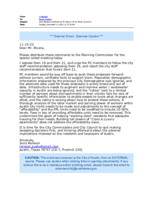
From: To: Subject: Date: JJ Reinken Rivera, Andrew Janis Reinken comments for PC Mtg 11-15-22, Items 19 and 21 Tuesday, November 15, 2022 11:33:39 AM *** External Email - Exercise Caution *** 11-15-22 Dear Mr. Rivera, Please distribute these comments to the Planning Commission for the special called meeting today. I oppose Item 19 and Item 21, and urge the PC members to follow the city staff recommendation opposing Item 19, and reject the city staff recommendation that favors Item 21. PC members would be way off base to push these proposals forward without current, verifiable facts to support them. Population demographic information prepared by the previous City Demographer was ignored, and the alternate data used for these proposals is overly broad and out of date. Infrastructure needs to augment and improve water / wastewater capacity in Austin are being ignored, and the "notice" sent to a limited number of persons about encroachments in their vicinity fails for lack of sufficiently specific information to enable people to know what changes are afoot, and the notice is lacking about how to protest these actions. A thorough analysis of the labor market and earning power of workers within Austin city limits needs to be made and adjustments to the concept of “affordability” and the FPL limits need to be modified to include 10-50% levels. Fees in lieu of providing affordable units need to be removed. This undermines the goals of helping "working class" residents find adequate housing for their needs. Building tall towers of "Class A Luxury Apartments" does not address the affordability issue. It is time for the City Commissions and City Council to quit making sweeping decisions first, and thinking afterward about the adverse implications imposed on the residents and taxpayers of Austin. Sincerely, Janis Reinken reinken.austx@gmail.com Austin, Texas 78757 (CD 7, Precinct 220) CAUTION: This email was received at the City of Austin, from an EXTERNAL source. Please use caution when clicking links or opening attachments. If you believe this to be a malicious and/or phishing email, please forward this email to cybersecurity@austintexas.gov.
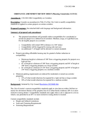
C20-2022-004 ORDINANCE AMENDMENT REVIEW SHEET (Planning Commission 11/15/22) Amendment: C20-2022-004 Compatibility on Corridors Description: Consider an amendment to Title 25 of the City Code to modify compatibility standards as applied to certain projects on certain corridors. Proposed Language: See attached draft code language and background information. Summary of proposed code amendment • The proposed amendment will generally reduce compatibility for a residential or mixed-use project on a defined set of corridors: Medium, Large, or Light Rail Line. For all eligible projects on a corridor: o Compatibility will extend 300’in distance (vs 540’ today) o Compatibility will be triggered by zoning only (not use) o An additional 5’ of height will be allowed vs current standards • Projects providing affordable housing may be granted a further reduction in compatibility: o Maximum height at a distance of 100’ from a triggering property for projects on a light rail line o 65’ of height at a distance of 100’ from a triggering property and 90’ of height at 200’ from a triggering property on a large corridor o 65’ of height at a distance of 150’ from a triggering property and 90’ of height at 250’ from a triggering property on a medium corridor • Minimum parking requirements are reduced for residential or mixed-use corridor properties: o 25% of what would otherwise be required for a light rail line or large corridor o 50% of what would otherwise be required for a medium corridor Background: Initiated by City Council Resolution 20220609-066. The City of Austin’s current compatibility standards apply to sites that are within 540 feet (or nearly two downtown blocks) of the property line of an urban family residence (SF-5) or more restrictive zoning district. Compatibility standards also apply when a site is adjacent to a lot on which a use permitted in an SF-5 or more restrictive zoning district is located. Current compatibility standards include: • Height and Setback Limitations • Scale and Clustering Requirements • Screening Requirements 11/15/2022 1 C20-2022-004 The dimensional characteristics of the City’s current compatibility standards are shown in the image below, with annotations in pink text showing the proposed compatibility standards along light rail lines, large corridors, and medium corridors as defined in the ordinance: Existing Compatibility Standards and Proposed Compatibility Standards Along Specified Corridors In June 2022, City Council adopted a resolution that directed staff to modify the application of compatibility to projects on certain …
Amend Commissi Section Pg # Proposed Amendment Proposed Text Change Text Change Included References and Notes (if ment # oner (Underline added text/Strikethrough deleted text) in Amendment (YES/NO) needed) 1 Shieh § 25-2-769.04 (D) 5 of 14 strike out "two stories" and "three stories" in this section The height limitation for Yes and remove the reference to stories from all other parts of a structure is: the ordinance. (1) two stories and 35 feet, if the structure is 50 feet or less from a triggering property; (2) three stories and 45 feet, if the structure is more than 50 feet and not more than 100 feet from a triggering property; or 2 3 Thompson § 25-2-769.06 (F) 10 and 11 of 14 Fee in lieu funds must be used within 1 mile of the property Shieh § 25-2-769.06 (F) 4 and 10 of 14 Allow the same compatibility standards on both light rail and within 0.25 miles of a corridor. No No We want housing in transit supported areas (2) and (3), and § 25-2-769.04 (B) (2) and large corridors. This standard should be the following: - a structure can reach allowable height if the structure is located at least 100 feet from a triggering property if it is participating in an affordable housing program. - a structure can reach allowable height if the structure is located at least 200 feet from a triggering property if it is not participating in an affordable housing program. [Proposed Amendment 1: Light rail not participating in an affordable housing program: 1) 65' @ >100' and <150' from triggering property, 2) 85' @ >150' and <200' from triggering property. This would allow by right density along light rail. 65' and 85' building heights are outside of line of sight with 35' and 45' heights at 25' and 50' from triggering property line respectively.] 4 Shieh § 25-2-769.06 (F) 4 and 10 of 14 The compatibility standards for medium corridors should No (4), and § 25-2- 769.04 (B) (2) be the following: - a structure can reach a maximum height of 65 ft if the structure is located at least 100 feet from a triggering property if it is participating in an affordable housing program. - a structure can reach a maximum height of 75 ft if the structure is located at least 150 feet from a triggering property if it is participating in an …
Palm District Planning Initiative Planning Commission November 15, 2022 Content Background and Study Area What We Heard Vision and Scenarios Implementation/Next Steps Background and Study Area Develop a shared vision for a complex, culturally rich, and rapidly transforming part of downtown Austin. 4 5 Resolution 20190523-029 Palm School Negotiations Rainey Street District Fund Fifth Street Mexican American Heritage Corridor Convention Center Expansion District Planning Process Improved Connectivity 6 WE ARE HERE 7 Equity-Based Goals Create a safe, welcoming place history Preserve and interpret Enhance educational and cultural assets Provide economic benefits Increase access to housing Improve mobility and access Improve access to nature, enhance natural systems, and support an equitable, sustainable, resilient future 8 What We Heard Participants • Visits to SpeakUp Austin! Webpage: 3,600 • Survey Responses: 700+ (3 Surveys) • Visioning Forum Attendees: 150+ • Targeted East Austin Outreach: 75 + (Individuals and Organizations) • AIA Event Participants: 60+ • Interactive Map Responses: 25+ 10 Survey Demographics 11 Visioning Forums 12 Targeted East Austin Engagement: • La Raza Roundtable • Current and Former Elected Officials • Greater Austin Hispanic Chamber of Commerce • Tejano Democrats • Palm School Alumni • The Emma S. Barrientos Mexican American Cultural Center (ESB-MACC) • La Pena Arts, Inc. • Mexic-Arte • Nuestro Grupo/Academia Cuauhtli • AHMIGA (Latina civic and social networking organization) • Café Con Letras • L.A.C.E. • PODER • Long-time East Austin residents 13 American Institute of Architects Recommendations: 14 Vision and Scenarios VISION The Palm District is a vibrant historic hub of downtown where the past is honored, culture is celebrated, and the future is shaped. Dense transit-oriented development is balanced with history and natural spaces creating physical connections that invite people to move easily to and through the district. The district is a dynamic place, growing and evolving, while actively retaining families and individuals who have traditionally called this place home. Creativity and innovation are cultivated, and people from Austin and beyond are welcome to live, relax, work, play, learn, and connect with others. 16 INCLUSIVE GROWTH Growth in the district will provide a prosperous future for longtime and recent residents and for established and new businesses. 17 CULTURE The district will become a destination that celebrates its multi- cultural heritage. 18 CONNECTION Physical, cultural and social connections will be strengthened within downtown and between …
From: To: Subject: Date: JJ Reinken Rivera, Andrew Janis Reinken comments for PC Mtg 11-15-22, Items 19 and 21 Tuesday, November 15, 2022 11:33:39 AM *** External Email - Exercise Caution *** 11-15-22 Dear Mr. Rivera, Please distribute these comments to the Planning Commission for the special called meeting today. I oppose Item 19 and Item 21, and urge the PC members to NOT follow the city staff recommendation opposing Item 19, and reject the city staff recommendation that favors Item 21. PC members would be way off base to push these proposals forward without current, verifiable facts to support them. Population demographic information prepared by the previous City Demographer was ignored, and the alternate data used for these proposals is overly broad and out of date. Infrastructure needs to augment and improve water / wastewater capacity in Austin are being ignored, and the "notice" sent to a limited number of persons about encroachments in their vicinity fails for lack of sufficiently specific information to enable people to know what changes are afoot, and the notice is lacking about how to protest these actions. A thorough analysis of the labor market and earning power of workers within Austin city limits needs to be made and adjustments to the concept of “affordability” and the FPL limits need to be modified to include 10-50% levels. Fees in lieu of providing affordable units need to be removed. This undermines the goals of helping "working class" residents find adequate housing for their needs. Building tall towers of "Class A Luxury Apartments" does not address the affordability issue. It is time for the City Commissions and City Council to quit making sweeping decisions first, and thinking afterward about the adverse implications imposed on the residents and taxpayers of Austin. Sincerely, Janis Reinken reinken.austx@gmail.com Austin, Texas 78757 (CD 7, Precinct 220) CAUTION: This email was received at the City of Austin, from an EXTERNAL source. Please use caution when clicking links or opening attachments. If you believe this to be a malicious and/or phishing email, please forward this email to cybersecurity@austintexas.gov.
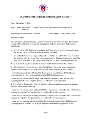
PLANNING COMMISSION RECOMMENDATION 20221115-19 Date: November 15, 2022 Subject: Code Amendment - Compatibility and Parking Requirements along Certain Roadways. Seconded By: Commissioner Azhar Motioned By: Commissioner Thompson Recommendation Recommend an ordinance amending City Code Title 25 to create a new overlay that modifies compatibility and parking requirements along certain roadways and include the following amendments: 1. § 25-2-769.04 (D), Strike out "two stories" and "three stories" in this section and remove the reference to stories from all other parts of the ordinance. To read as follows: “The height limitation for a structure is: (1) two stories and 35 feet, if the structure is 50 feet or less from a triggering property; (2) three stories and 45 feet, if the structure is more than 50 feet and not more than 100 feet from a triggering property; or” 2. § 25-2-769.06 (F), Fee in lieu funds must be used within 0.25 miles of a corridor. 3. § 25-2-769.06 (F) (2) and (3), and § 25-2-769.04 (B) (2), Allow the same compatibility standards on both light rail and large corridors. This standard should be the following: - a structure can reach allowable height if the structure is located at least 100 feet from a triggering property if it is participating in an affordable housing program. - a structure can reach allowable height if the structure is located at least 200 feet from a triggering property if it is not participating in an affordable housing program. 4. § 25-2-769.06 (F) (4), and § 25-2-769.04 (B) (2), The compatibility standards for medium corridors should be the following: - a structure can reach a maximum height of 65 ft if the structure is located at least 100 feet from a triggering property if it is participating in an affordable housing program. - a structure can reach a maximum height of 85 ft if the structure is located at least 150 feet from a triggering property if it is participating in an affordable housing program. - a structure can reach the allowable height if the structure is located at least 200 feet from a triggering property, whether it is participating in an affordable housing program or not. 1 of 2 5. § 25-2-769.04 (C), Define what is or is not allowed in the 25 foot compatibility setback. We should ensure that refuse uses such as dumpsters are not allowed and buildings, meaning covered spaces which a human …
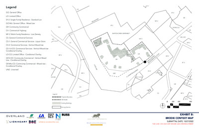
Legend GO: General Office LO: Limited Office SF-2: Single-Family Residence - Standard Lot GO-MU: General Office - Mixed Use GR: Community Commercial CH: Commercial Highway GO MF-2: Multi-Family Residence - Low Density CS: General Commercial Services CS-1: General Commercial Services - Liquor Store CS-V: Commercial Services - Vertical Mixed Use GO CS-1-V-CO: Commercial Services - Vertical Mixed Use Conditional Overlay LO-CO: Limited Office - Conditional Overlay MF-2 GR-V-CO: Community Commercial - Vertical Mixed Use - Conditional Overlay GR-MU-CO: Community Commercial - Mixed Use - Conditional Overlay UNZ - Unzoned SF-2 SF-2 GO-MU LO R E F F U 0 ’ B 0 5 SF-2 LO CS BARTON CREEK GREENBELT MF-4 L O O P 3 6 0 MF-2 UNZ CS-1-V-CO CS-1 GR GR CS U S S T O P O E T R R A PID B GR-V A PIT A L M E T R O M C CS-V D R A V E L U O R B A CS-1-V-CO M A S . L CS CH GO GR Legend: Property Boundary 500’ Buffer Existing Buildings Zoning Districts MF-2 SF-2 GR GR-MU-CO GR-V-CO GR MF-2 SF-3 SF-5 SF-3 GR SF-6 SF-3 CS-1-V CS CS MF-2 LO-CO SF-6 0 200 400 800 EXHIBIT B: BRODIE CONTEXT MAP SUBMITTAL DATE: 10/27/2022 PUD CASE: C814-2021-0099 BRODIE OAKS REDEVELOPMENT SITE METRICS 37.6 Acres / 1,637,856 Sq. Ft. 56% NSA; 54% GSA 5,750 Sq. Ft. 50 feet Total Site Area Proposed Impervious Cover Minimum Lot Size Minimum Lot Width Minimum Setbacks Front Street Side Yard Interior Side Yard Rear Yard 0 feet 0 feet 0 feet 0 feet LAND USE AREA METRICS Acres Building Cover Impervious Cover* Non- Residential Maximum Hotel Maximum Residential Max. % Max. Sq. Ft. Keys Sq. Ft. Units Sq. Ft. 1,400,000 200 200,000 1,700 1,500,000 11.7 .5% 5,000 -- -- -- -- Max. 95% 25.9 Land Use Area 1 Land Use Area 2 Site Total 37.6 95% 7.5% 56% *Maximum impervious cover is based on Net Site Area (NSA) and will be tracked by site plan in compliance with Exhibit H - Brodie Oaks Redevelopment Phasing Plan. Impervious Cover will be higher on a site-by-site basis. Maximum floor-to-area ratio is not applicable to the Brodie Oaks Redevelopment. L O O P 3 6 0 BARTON CREEK GREENBELT Legend: Property Boundary Private Streets with Public Access Easements Land Use Area 1 Land Use Area 2 U S S T …
ZONING CHANGE REVIEW SHEET CASES: C814-2021-0099 – Brodie Oaks Redevelopment PUD DISTRICT: 5 C14R-81-033(RCA) – Brodie Oaks Restrictive Covenant Amendment ZONING FROM: Unzoned; GR; CS; CS-1 TO: PUD ADDRESS: 4021, 4025, 4107, 4109, 4115, and 4141 South Capital of Texas Highway Northbound; 3940, 4006, 4024 - 4040, 4200, 4220, 4236 South Lamar Boulevard Southbound SITE AREA: 37.606 acres PROPERTY OWNER: Lionstone Investments, LCFRE Austin Brodie Oaks LLC (John Schaefer) AGENT: Lionheart Places (Rebecca Leonard) CASE MANAGER: Wendy Rhoades (512-974-7719, wendy.rhoades@austintexas.gov) STAFF RECOMMENDATIONS: The Staff recommendation is to grant planned unit development (PUD) district zoning, as shown in the Land Use Plan as provided Exhibits C, D, E, F, G, H, I, J, and K. For a summary of the basis of Staff’s recommendation, see pages 3 - 14. The Restrictive Covenant includes all recommendations listed in the Transportation Impact Analysis Memo, dated August 31, 2022, as provided in Attachment A. The Staff recommendation is to grant an amendment of the 1981 Restrictive Covenant and terminate the height limitations for Tracts A1, A2, A3, A4, and B as it applies to this property. For a summary of the basis of Staff’s recommendation, see pages 3 - 14. PARKS AND RECREATION BOARD: September 26, 2022: RECOMMENDED TO THE CITY COUNCIL THE BRODIE OAKS PUD AS SUPERIOR IF THE APPLICANT AGREES TO: 1) WORK WITH STAFF AND ATD TO PROVIDE 10 FREE PARKING SPACES TO THE NEIGHBORHOOD PARK SITE; 2) AMEND THE APPLICATION TO STATE THERE WILL BE A PUBLICLY AVAILABLE RESTROOM AT THE NEIGHBORHOOD PARK; 3) CONTINUE TO WORK WITH THE HILL COUNTRY CONSERVANCY AND AUSTIN PARKS FOUNDATION TO ENSURE THIS IS A SUSTAINABLE TRAIL ACCESSING THE BARTON CREEK GREENBELT, AND 4) INVESTIGATE AND REPORT BACK ON METHODS TO FUND OFF-SITE BARTON CREEK GREENBELT PRESERVATION AND MANAGEMENT THROUGH COMMERCIAL DEVELOPMENT AT THE SITE (refer to Attachment C) [S. FAUST; N. BARNARD – 2ND] (9-0) D. LEWIS AND K. TAYLOR – ABSENT 21 of 103 ENVIRONMENTAL COMMISSION RECOMMENDATION: November 2, 2022: PLANNING COMMISSION ACTION: November 8, 2022: May 24, 2022: APPROVED AN INDEFINITE POSTPONEMENT REQUEST BY STAFF R. SCHNEIDER; J. THOMPSON – 2ND] (9-0) Y. FLORES, C. HEMPEL, J. MUSHTALER – ABSENT December 14, 2021: APPROVED AN INDEFINITE POSTPONEMENT REQUEST BY STAFF [A. AZHAR; R. SCHNEIDER – 2ND] (11-0) P. HOWARD – OFF THE DAIS; J. SHIEH – ABSENT CITY COUNCIL ACTION: December 1, 2022: ORDINANCE NUMBER: ISSUES: Austin Energy has requested that …
ZONING CHANGE REVIEW SHEET C14R-81-033(RCA) – Brodie Oaks Restrictive Covenant Amendment CASES: C814-2021-0099 – Brodie Oaks Redevelopment PUD DISTRICT: 5 ZONING FROM: Unzoned; GR; CS; CS-1 ADDRESS: 4021, 4025, 4107, 4109, 4115, and 4141 South Capital of Texas Highway Northbound; 3940, 4006, 4024 - 4040, 4200, 4220, 4236 South Lamar Boulevard Southbound SITE AREA: 37.606 acres PROPERTY OWNER: Lionstone Investments, LCFRE Austin Brodie Oaks LLC TO: PUD (John Schaefer) AGENT: Lionheart Places (Rebecca Leonard) CASE MANAGER: Wendy Rhoades (512-974-7719, wendy.rhoades@austintexas.gov) STAFF RECOMMENDATIONS: The Staff recommendation is to grant planned unit development (PUD) district zoning, as shown in the Land Use Plan as provided Exhibits C, D, E, F, G, H, I, J, and K. For a summary of the basis of Staff’s recommendation, see pages 3 - 14. The Restrictive Covenant includes all recommendations listed in the Transportation Impact Analysis Memo, dated August 31, 2022, as provided in Attachment A. The Staff recommendation is to grant an amendment of the 1981 Restrictive Covenant and terminate the height limitations for Tracts A1, A2, A3, A4, and B as it applies to this property. For a summary of the basis of Staff’s recommendation, see pages 3 - 14. PARKS AND RECREATION BOARD: September 26, 2022: RECOMMENDED TO THE CITY COUNCIL THE BRODIE OAKS PUD AS SUPERIOR IF THE APPLICANT AGREES TO: 1) WORK WITH STAFF AND ATD TO PROVIDE 10 FREE PARKING SPACES TO THE NEIGHBORHOOD PARK SITE; 2) AMEND THE APPLICATION TO STATE THERE WILL BE A PUBLICLY AVAILABLE RESTROOM AT THE NEIGHBORHOOD PARK; 3) CONTINUE TO WORK WITH THE HILL COUNTRY CONSERVANCY AND AUSTIN PARKS FOUNDATION TO ENSURE THIS IS A SUSTAINABLE TRAIL ACCESSING THE BARTON CREEK GREENBELT, AND 4) INVESTIGATE AND REPORT BACK ON METHODS TO FUND OFF-SITE BARTON CREEK GREENBELT PRESERVATION AND MANAGEMENT THROUGH COMMERCIAL DEVELOPMENT AT THE SITE (refer to Attachment C) [S. FAUST; N. BARNARD – 2ND] (9-0) D. LEWIS AND K. TAYLOR – ABSENT 31 of 103 C814-2021-0099 / C14R-81-033(RCA) Page 2 ENVIRONMENTAL COMMISSION RECOMMENDATION: November 2, 2022: PLANNING COMMISSION ACTION: November 8, 2022: May 24, 2022: APPROVED AN INDEFINITE POSTPONEMENT REQUEST BY STAFF R. SCHNEIDER; J. THOMPSON – 2ND] (9-0) Y. FLORES, C. HEMPEL, J. MUSHTALER – ABSENT December 14, 2021: APPROVED AN INDEFINITE POSTPONEMENT REQUEST BY STAFF [A. AZHAR; R. SCHNEIDER – 2ND] (11-0) P. HOWARD – OFF THE DAIS; J. SHIEH – ABSENT CITY COUNCIL ACTION: December 1, 2022: ORDINANCE NUMBER: ISSUES: …
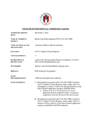
ITEM FOR ENVIRONMENTAL COMMISSION AGENDA November 2, 2022 Brodie Oaks Redevelopment PUD C814-2021-0099 Armbrust & Brown (David Armbrust) 4107 S Capital of Texas Highway COMMITTEE MEETING DATE: NAME & NUMBER OF PROJECT: NAME OF APPLICANT OR ORGANIZATION: LOCATION: COUNCIL DISTRICT: 5 ENVIRONMENTAL REVIEW STAFF: Leslie Lilly, Environmental Program Coordinator, (512)535- 8914, Leslie.lilly@austintexas.gov WATERSHED: Barton Creek Watershed/Barton Springs Zone REQUEST: PUD zoning for the property STAFF RECOMMENDATION: STAFF CONDITION: Staff recommended with conditions A. Development associated with C814-2021-0099, located at 4107 S Capital of Texas Highway, shall comply with 25-8, Subchapter A, Article 13 (Save Our Springs Initiative) at the time of permit application except as modified below. a. Section A of 25-8-514 (Pollution Prevention Required) shall be modified to allow a maximum impervious cover for the site of 56% net site area. B. Development associated with C814-2021-0099, located at 4107 S Capital of Texas Highway, shall comply with 25-8 Section A (Water Quality) at the time of permit application except as modified by the PUD ordinance. a. ECM 1.6.7.5 (D) shall be modified to allow captured runoff for beneficial reuse b. 25-8-341 shall be modified to allow cut not to exceed a maximum of fourteen (14) feet. c. 25-8-342 shall be modified to allow fill not to exceed a maximum of fourteen (14) feet. d. 25-8-281 shall be modified to allow encroachment into CEFs as indicated on Exhibit F. C. Additionally, development associated with C814-2021-0099, located at 4107 S Capital of Texas Highway, shall comply with the following requirements a. Reduction in impervious cover from 84% NSA to 56% NSA b. Bring the site into compliance with SOS water quality treatment requirements c. Clustering impervious cover and disturbance 75’-250’ away from Barton Creek Greenbelt d. Restoring 2 acres of the tract to native vegetation e. Provide 100% GSI for water quality controls. f. Provide rainwater harvesting for landscape irrigation of not less than 50% of the landscaped area. g. Provide superior tree protections. h. Comply with Austin Green Building 3-star rating i. Exceed landscaping requirements. j. Provide superior open space and parkland dedication. COMMITTEE MEETING DATE: NAME & NUMBER OF PROJECT: NAME OF APPLICANT OR ORGANIZATION: LOCATION: ENVIRONMENTAL REVIEW STAFF: WATERSHED: REQUEST: COUNCIL DISTRICT: 5 STAFF RECOMMENDATION: STAFF CONDITION: ITEM FOR ENVIRONMENTAL COMMISSION AGENDA November 2, 2022 Brodie Oaks Redevelopment Site Specific SOS Amendment C814-2021-0099 Armbrust & Brown (David Armbrust) 4107 S Capital of Texas Highway Leslie Lilly, Environmental Program …
City of Austin Housing and Plannin g Department P.O. Box 1088, Austin, TX 78767 -1088 (512) 974-3100 ♦ Fax (512) 974-3112 ♦ www .c ity o fau s tin .o rg/ h ou s in g MEMORANDUM TO: Todd W. Shaw, Chair & Planning Commission Members November 1, 2022 Maureen Meredith, Senior Planner, Inclusive Planning Division Housing and Planning Department NPA-2022-0007.01_10810 Newmont Rd North Austin Civic Association Neighborhood Planning Area FROM: DATE: RE: Staff requests a postponement of this case from the November 8, 2022 Planning Commission hearing to the November 15, 2022 hearing date so the plan amendment case can be on the same agenda as the associated zoning case. The postponement request was made in a timely manner and meets the Planning Commission’s policy. Attachment: Plan Amendment Map Zoning Map The City of Austin is committed to compliance with the Americans with Disabilities Act and will provide reasonable modifications and equal access to communications upon request. 1 of 25 The City of Austin is committed to compliance with the Americans with Disabilities Act and will provide reasonable modifications and equal access to communications upon request. 2 of 25
Planning Commission: November 8, 2022 NEIGHBORHOOD PLAN AMENDMENT REVIEW SHEET DATE FILED: June 29, 2022 (out-of-cycle) NEIGHORHOOD PLAN: East Cesar Chavez CASE#: NPA-2022-0002.01 PROJECT NAME: 1700 E. 2nd Street PC DATE: November 8, 2022 ADDRESS/ES: 1700 E. 2nd Street & 205 Chalmers Ave. DISTRICT AREA: SITE AREA: 0.51 acres OWNER/APPLICANT: 2nd Street, LLC AGENT: Drenner Group, PC (Leah M. Bojo) CASE MANAGER: Maureen Meredith STAFF EMAIL: Maureen.Meredith@austintexas.gov TYPE OF AMENDMENT: Change in Future Land Use Designation 3 From: Multifamily Residential To: Mixed Use Base District Zoning Change Related Zoning Case: C14-2022-0091 From: CS-MU-CO-NP To: CS-MU-V-NP NEIGHBORHOOD PLAN ADOPTION DATE: May 13, 1999 CITY COUNCIL DATE: December 8, 2022 PLANNING COMMISSION RECOMMENDATION: November 8, 2022 - ACTION: PHONE: (512) 974-2695 1 of 296 Planning Commission: November 8, 2022 STAFF RECOMMENDATION: Staff supports the applicant’s request to change the future land use map from Multifamily Residential to Mixed use. BASIS FOR STAFF’S RECOMMENDATION: Staff supports the applicant’s request for Mixed Use land use because there is existing Mixed Use land use to the north and south of the property. The property is located near public transportation and numerous commercial uses. It is approximately 0.4 miles from the Plaza Saltillo TOD Station. The property is in an area where a mixed use is appropriate. Mixed Use Mixed Use Mixed Use Below are sections of the East Cesar Chavez Neighborhood plan that supports the applicant’s request. 2 2 of 296 Planning Commission: November 8, 2022 LAND USE DESCRIPTIONS EXISTING LAND USE ON THE PROPERTY Multifamily Residential - Higher-density housing with 3 or more units on one lot. 1. Preserve existing multifamily and affordable housing; 2. Maintain and create affordable, safe, and well-managed rental housing; and 3. Make it possible for existing residents, both homeowners and renters, to continue to live in their neighborhoods. 4. Applied to existing or proposed mobile home parks. Purpose Application 1. Existing apartments should be designated as multifamily unless designated as mixed use; 2. Existing multifamily-zoned land should not be recommended for a less intense land use category, unless based on sound planning principles; and 3. Changing other land uses to multifamily should be encouraged on a case-by-case basis PROPOSED LAND USE ON THE PROPERTY Mixed Use - An area that is appropriate for a mix of residential and non‐residential uses. Purpose 1. Encourage more retail and commercial services within walking distance of residents; 2. Allow live‐work/flex space on existing …
ZONING CHANGE REVIEW SHEET CASE: C14-2022-0091 1700 E. 2nd Street DISTRICT: 3 ZONING FROM: CS-MU-CO-NP TO: CS-MU-V-NP ADDRESS: 1700 East 2nd Street and 205 Chalmers Avenue SITE AREA: 0.51 acres PROPERTY OWNER: 2nd Street, LLC AGENT: Drenner Group, PC (Leah Bojo) CASE MANAGER: Heather Chaffin (512-974-2122, heather.chaffin@austintexas.gov) STAFF RECOMMENDATION: Staff supports CS-MU-V-CO-NP with the following conditions: 1. The following uses are prohibited: Adult oriented businesses, Commercial off-street parking, Convenience storage, Equipment repair services, Kennels, Residential treatment, Outdoor entertainment, Campground, Communication service facilities, Drop-off recycling collection facilities, Equipment sales, Pawn shop services, Vehicle storage and Transportation terminal. 2. The following uses are conditional: Agricultural sales and services, Automotive repair services, Automotive washing (of any type), College and university facilities, Construction sales and services, Electronic prototype assembly, Guidance services, Hotel-motel, Limited warehousing and distribution, Off-site accessory parking, Research services, Restaurant (limited), Service station, Club or lodge, Automotive rentals, Automotive sales, Building maintenance services, Communications services, Custom manufacturing, Exterminating services, Hospital services (limited), Indoor entertainment, Local utility services, Outdoor sports and recreation, Restaurant (drive- in, fast food), Restaurant (general), Hospital services (general) and Transitional housing. For a summary of the basis of staff’s recommendation, see case manager comments on page 2. PLANNING COMMISSION ACTION / RECOMMENDATION: November 8, 2022: CITY COUNCIL ACTION: December 8, 2022: ORDINANCE NUMBER: 1 of 87 C14-2022-0091 2 ISSUES: The Applicant is proposing to remove two of the existing conditional overlays on the site and retain the remainder of conditions, as listed in the Staff Recommendation on Page 1 of this report. The Applicant proposes removing the 40’ height limit and removing townhouse use from the list of prohibited uses. CASE MANAGER COMMENTS: The subject property is located at the northeast corner of Chalmers Avenue and East 2nd Street. The property is zoned CS-MU-CO-NP and is developed with two buildings. Land uses on the site include Food sales and Personal services. The lot immediately north of the property is zoned CS-MU-CO-NP and contains Indoor and Outdoor entertainment uses. The lot immediately east of the property is also zoned CS-MU-CO-NP and is developed with a mix of commercial uses. Across Chalmers Avenue to the west is Austin Academy, zoned CS, and Pathways at Chalmers Court, a MF-4-NP zoned property developed with affordable multifamily units. Across 2nd Street to the south is property zoned CS-MU-CO-NP that is used for Vehicle storage. Capital Metro bus route 490 is adjacent to the site …
No NEIGHBORHOOD PLAN AMENDMENT REVIEW SHEET DATE FILED: July 29, 2022 (In-cycle) NEIGHORHOOD PLAN: Holly CASE#: NPA-2022-0010.03 PROJECT NAME: Holly Mixed Use PC DATE: November 8, 2022 ADDRESS/ES: 2309 E. 2nd St.; 2320 E. Cesar Chavez S.t; 2315 E. 2nd S.t; 2403 E. 2nd St.; 2405 E. 2nd St.; 2409 E. 2nd St; 2411 E. 2nd St. DISTRICT AREA: 3 SITE AREA: 1.1066 acres OWNERS/APPLICANTS: 2309 2nd St./2320 E. Cesar Chavez St.: 2324 ECC-Arc LLC, a Delaware limited liability company; 2315 E. 2nd St.: 2400 ECC-Arc LLC, a Delaware limited liability company; 2403 E. 2nd Street: Steven Yarak, Larry Yarak, Brenda Blair; 2405 E. 2nd Street: Danielle Murray; 2409 E. 2nd Street: Eleanore Bacon; 2411 E. 2nd Street: Ricardo David Rojo AGENT: Armbrust and Brown, PLLC (Ferris Clements) CASE MANAGER: Maureen Meredith STAFF EMAIL: Maureen.Meredith@austintexas.gov TYPE OF AMENDMENT: Change in Future Land Use Designation PHONE: (512) 974-2695 From: Single Family and Civic Base District Zoning Change Related Zoning Case: (not filed) From: To: Mixed Use To: NEIGHBORHOOD PLAN ADOPTION DATE: December 13, 2001 CITY COUNCIL DATE: December 1, 2022 ACTION: 1 of 288 No PLANNING COMMISSION RECOMMENDATION: November 8, 2022 - STAFF RECOMMENDATION: Staff supports the applicant’s request for Mixed Use land use. BASIS FOR STAFF’S RECOMMENDATION: Staff supports the applicant’s request because the properties abut Mixed Use land use to the south. Extending the Mixed Use land use north to E. 2nd Street is appropriate. East Cesar Chavez Street is an activity corridor and is directly south of the properties. No zoning case has been filed at this time. This project is proposed to be developed with previously filed NPA and Zoning cases associated with the property outlined in red below. The case numbers for that those cases are NPA-2021-0010.01 (Mixed Use request) and C14-2021-0121 (CS-MU-V-NP request). These previously filed cases have not been acted upon by Planning Commission or City Council at this time. Multifamily Residential NPA-2021-0010.01 will be developed with this project for NPA-2022-0010.03 Mixed Use LAND USE DESCRIPTIONS EXISTING LAND USE ON THE PROPERTY Civic - Any site for public or semi public facilities, including governmental offices, police, fire facilities, hospitals, and public and private schools. Includes major religious facilities and other religious activities that are of a different type and scale than surrounding uses. Purpose 1. Allow flexibility in development for major, multi community; functional institutional uses that serve the greater ‐ ‐ 2 of …
City of Austin Housing and Plannin g Department P.O. Box 1088, Austin, TX 78767 -1088 (512) 974-3100 ♦ Fax (512) 974-3112 ♦ www .c ity o fau s tin .o rg/ h ou s in g MEMORANDUM TO: FROM: DATE: RE: Todd W. Shaw, Chair & Planning Commission Members Maureen Meredith, Senior Planner, Inclusive Planning Division Housing and Planning Department November 1, 2022 NPA-2021-0005.02_2601 Montopolis Dr., 6700 & 6800 E. Ben White Blvd (Montopolis Multifamily) No zoning application has not been filed at this time The applicant requests a postponement of this case from the November 8, 2022 Planning Commission hearing to the December 13, 2022 hearing date. Please see Victoria Haase’s attached email. The postponement request was made in a timely manner and meets the Planning Commission’s policy. Attachments: Email from Victoria Haase, Thrower Design Plan Amendment Map The City of Austin is committed to compliance with the Americans with Disabilities Act and will provide reasonable modifications and equal access to communications upon request. 1 of 309 From: Victoria Sent: Tuesday, November 1, 2022 9:19 AM To: Meredith, Maureen <Maureen.Meredith@austintexas.gov> Cc: Ron Thrower Subject: NPA-2021--0005.01_2601 Montopolis Drive *** External Email - Exercise Caution *** Maureen – We request a postponement of this case from the November 8, 2022, agenda to the December 13, 2022 agenda. We remain working with the Neighborhood and the City of Austin (Austin Fire Department and ATD) regarding matters related to the proposed development. Thank you, Victoria Haase www.throwerdesign.com 512-998-5900 Cell 512-476-4456 Office Mail: P.O. Box 41957 Austin, Texas 78704 The City of Austin is committed to compliance with the Americans with Disabilities Act and will provide reasonable modifications and equal access to communications upon request. 2 of 309 The City of Austin is committed to compliance with the Americans with Disabilities Act and will provide reasonable modifications and equal access to communications upon request. 3 of 309 The City of Austin is committed to compliance with the Americans with Disabilities Act and will provide reasonable modifications and equal access to communications upon request. 4 of 309 Planning Commission: November 8, 2022 NEIGHBORHOOD PLAN AMENDMENT REVIEW SHEET DATE FILED: July 27, 2021 (In-cycle) NEIGHORHOOD PLAN: Montopolis CASE#: NPA-2021-0005.02 PROJECT NAME: Montopolis Multifamily PC DATES: November 8, 2022 October 11, 2022 August 23, 2022 July 12, 2022 May 24, 2022 April 26, 2022 March 22, 2022 February 22, 2022 February 8, 2022 January 11, 2022 ADDRESS/ES: …
PLANNING COMMISSION AGENDA Tuesday, November 8, 2022 The Planning Commission will convene at 6:00 PM on Tuesday, November 8, 2022 at City Hall, Council Chambers 1001 301 W. Second Street, Austin, TX. Some members of the Planning Commission may be participating by videoconference. The meeting may be viewed online at: http://www.austintexas.gov/page/watch-atxn-live Greg Anderson Awais Azhar Grayson Cox Yvette Flores – Secretary Claire Hempel – Vice-Chair Patrick Howard Jennifer Mushtaler Carmen Llanes Pulido Robert Schneider Todd Shaw – Chair James Shieh – Parliamentarian Jeffrey Thompson District 2 - Vacant Ex-Officio Members Arati Singh – AISD Board of Trustees Jessica Cohen – Chair of Board of Adjustment Spencer Cronk - City Manager Richard Mendoza - Director of Public Works EXECUTIVE SESSION (No public discussion) The Planning Commission will announce it will go into Executive Session, if necessary, pursuant to Chapter 551 of the Texas Government Code, to receive advice from Legal Counsel on matters specifically listed on this agenda. The Commission may not conduct a closed meeting without the approval of the city attorney. Private Consultation with Attorney – Section 551.071 Attorney: Steven Maddoux, 512-974-6080 Commission Liaison: Andrew Rivera, 512-974-6508 PUBLIC COMMUNICATION The first four (4) speakers signed up prior to the commencement of the meeting will each be allowed a three-minute allotment to address their concerns regarding items not posted on the agenda. APPROVAL OF MINUTES 1. Approve the minutes of October 25, 2022. PUBLIC HEARINGS 2. Zoning and C814-2021-0099 - Brodie Oaks Redevelopment PUD; District 5 Rezoning: Location: Owner/Applicant: Agent: Request: Staff Rec.: Staff: 3. Restrictive Covenant Amendment: Location: Owner/Applicant: Agent: Request: Staff Rec.: Staff: 4021, 4025, 4107, 4109, 4115, and 4141 South Capital of Texas Highway Northbound; 3940, 4006, 4024 - 4040, 4200, 4220, 4236 South Lamar Boulevard Southbound, Barton Creek Watershed – Barton Springs Zone Lionstone Investments, LCFRE Austin Brodie Oaks LLC (John Schaefer) Lionheart Places (Rebecca Leonard) Unzoned; GR; CS; CS-1 to PUD Recommended, with conditions Wendy Rhoades, 512-974-7719, wendy.rhoades@austintexas.gov Housing and Planning Department C14R-81-033(RCA) - Brodie Oaks Restrictive Covenant Amendment; District 5 4021, 4025, 4107, 4109, 4115, and 4141 South Capital of Texas Highway Northbound; 3940, 4006, 4024 - 4040, 4200, 4220, 4236 South Lamar Boulevard Southbound, Barton Creek Watershed – Barton Springs Zone; South Lamar Combined (Barton Hills) (Suspended) NP Area Lionstone Investments, LCFRE Austin Brodie Oaks LLC (John Schaefer) Armbrust & Brown, PLLC (Jewels Cain) Amend the existing Restrictive Covenant for Lots A and …
ITEM FOR ENVIRONMENTAL COMMISSION AGENDA November 2, 2022 Brodie Oaks Redevelopment PUD C814-2021-0099 Armbrust & Brown (David Armbrust) 4107 S Capital of Texas Highway COMMITTEE MEETING DATE: NAME & NUMBER OF PROJECT: NAME OF APPLICANT OR ORGANIZATION: LOCATION: COUNCIL DISTRICT: 5 ENVIRONMENTAL REVIEW STAFF: Leslie Lilly, Environmental Program Coordinator, (512)535- 8914, Leslie.lilly@austintexas.gov WATERSHED: Barton Creek Watershed/Barton Springs Zone REQUEST: PUD zoning for the property STAFF RECOMMENDATION: STAFF CONDITION: Staff recommended with conditions A. Development associated with C814-2021-0099, located at 4107 S Capital of Texas Highway, shall comply with 25-8, Subchapter A, Article 13 (Save Our Springs Initiative) at the time of permit application except as modified below. a. Section A of 25-8-514 (Pollution Prevention Required) shall be modified to allow a maximum impervious cover for the site of 56% net site area. B. Development associated with C814-2021-0099, located at 4107 S Capital of Texas Highway, shall comply with 25-8 Section A (Water Quality) at the time of permit application except as modified by the PUD ordinance. a. ECM 1.6.7.5 (D) shall be modified to allow captured runoff for beneficial reuse b. 25-8-341 shall be modified to allow cut not to exceed a maximum of fourteen (14) feet. c. 25-8-342 shall be modified to allow fill not to exceed a maximum of fourteen (14) feet. d. 25-8-281 shall be modified to allow encroachment into CEFs as indicated on Exhibit F. C. Additionally, development associated with C814-2021-0099, located at 4107 S Capital of Texas Highway, shall comply with the following requirements a. Reduction in impervious cover from 84% NSA to 56% NSA b. Bring the site into compliance with SOS water quality treatment requirements c. Clustering impervious cover and disturbance 75’-250’ away from Barton Creek Greenbelt d. Restoring 2 acres of the tract to native vegetation e. Provide 100% GSI for water quality controls. f. Provide rainwater harvesting for landscape irrigation of not less than 50% of the landscaped area. g. Provide superior tree protections. h. Comply with Austin Green Building 3-star rating i. Exceed landscaping requirements. j. Provide superior open space and parkland dedication. COMMITTEE MEETING DATE: NAME & NUMBER OF PROJECT: NAME OF APPLICANT OR ORGANIZATION: LOCATION: ENVIRONMENTAL REVIEW STAFF: WATERSHED: REQUEST: COUNCIL DISTRICT: 5 STAFF RECOMMENDATION: STAFF CONDITION: ITEM FOR ENVIRONMENTAL COMMISSION AGENDA November 2, 2022 Brodie Oaks Redevelopment Site Specific SOS Amendment C814-2021-0099 Armbrust & Brown (David Armbrust) 4107 S Capital of Texas Highway Leslie Lilly, Environmental Program …
ENVIRONMENTAL COMMISSION MOTION 20221102-002 Date: November 2, 2022 Subject: Brodie Oaks Redevelopment PUD, C814-2021-0099 Seconded by: Kevin Ramberg Motion by: Jennifer Bristol WHEREAS, the Environmental Commission recognizes the applicant is Request PUD zoning for the property and; WHEREAS, the Environmental Commission recognizes that the applicant is proposing 11 acres of parkland dedication, although the density dictates 29 acres, and the applicant is proposing to address the additional 18 acres with a pay in lieu fee, and the Environmental Commission recognizes the environmental fragility of the area; and WHEREAS, the Environmental Commission recognizes the site is located in the Barton Creek Watershed and the Barton Springs Zone; and WHEREAS, the Environmental Commission recognizes that Staff recommends this PUD with conditions. THEREFORE, the Environmental Commission recommends the Brodie Oaks Redevelopment PUD with the following conditions: Staff Conditions: A. Development associated with C814-2021-0099, located at 4107 S Capital of Texas Highway, shall comply with 25-8, Subchapter A, Article 13 (Save Our Springs Initiative) at the time of permit application except as modified below. a. Section A of 25-8-514 (Pollution Prevention Required) shall be modified to allow a maximum impervious cover for the site of 56% net site area. B. Development associated with C814-2021-0099, located at 4107 S Capital of Texas Highway, shall comply with 25-8 Section A (Water Quality) at the time of permit application except as modified by the PUD ordinance. a. ECM 1.6.7.5 (D) shall be modified to allow captured runoff for beneficial reuse b. 25-8-341 shall be modified to allow cut not to exceed a maximum of fourteen (14) feet. c. 25-8-342 shall be modified to allow fill not to exceed a maximum of fourteen (14) feet. d. 25-8-281 shall be modified to allow encroachment into CEFs as indicated on Exhibit F. C. Additionally, development associated with C814-2021-0099, located at 4107 S Capital of Texas Highway, shall comply with the following requirements 1 a. Reduction in impervious cover from 84% NSA to 56% NSA b. Bring the site into compliance with SOS water quality treatment requirements c. Clustering impervious cover and disturbance 75-250’ away from Barton Creek Greenbelt d. Restoring 2 acres of the tract to native vegetation e. Provide 100% GSI for water quality controls f. Provide rainwater harvesting for landscape irrigation of not less than 50% of the landscaped area g. Provide superior tree protections h. Comply with Austin Green Building 3-star rating i. Exceed landscaping requirements j. …
ENVIRONMENTAL COMMISSION MOTION 20221102-003 Seconded by: Kevin Ramberg Date: November 2, 2022 Subject: Brodie Oaks Redevelopment Site Specific SOS Amendment, C814-2021-0099 Motion by: Jennifer Bristol WHEREAS, the Environmental Commission recognizes the applicant is making a request in response to Council Resolution 20221011-076, consider a site-specific amendment to City Code Chapter 25-8, Subchapter A, Article 13 (Save Our Springs Initiative), as minimally required to allow for limits to impervious cover as proposed in application C814-2021-0099 for the Brodie Oaks PUD development. The proposed site-specific amendment should be included as part of the discussion and consideration of the Brodie Oaks PUD development and; WHEREAS, the Environmental Commission recognizes the site is located in the Barton Creek Watershed and the Barton Springs Zone; and WHEREAS, the Environmental Commission recognizes that Staff recommends this Site Specific SOS Amendment with conditions. THEREFORE, the Environmental Commission recommends the Brodie Oaks Redevelopment Site Specific SOS Amendment with the following conditions: Staff Conditions: A. Development associated with C814-2021-0099, located at 4107 S Capital of Texas Highway, shall comply with 25-8, Subchapter A, Article 13 (Save Our Springs Initiative) at the time of permit application except as modified below. a. Section A of 25-8-514 (Pollution Prevention Required) shall be modified to allow a maximum impervious cover for the site of 56% net site area. B. Development associated with C814-2021-0099, located at 4107 S Capital of Texas Highway, shall comply with 25-8 Section A (Water Quality) at the time of permit application except as modified by the PUD ordinance. a. ECM 1.6.7.5 (D) shall be modified to allow captured runoff for beneficial reuse b. 25-8-341 shall be modified to allow cut not to exceed a maximum of fourteen (14) feet. c. 25-8-342 shall be modified to allow fill not to exceed a maximum of fourteen (14) feet. d. 25-8-281 shall be modified to allow encroachment into CEFs as indicated on Exhibit F. C. Additionally, development associated with C814-2021-0099, located at 4107 S Capital of Texas Highway, shall comply with the following requirements 1 a. Reduction in impervious cover from 84% NSA to 56% NSA b. Bring the site into compliance with SOS water quality treatment requirements c. Clustering impervious cover and disturbance 75-250’ away from Barton Creek Greenbelt d. Restoring 2 acres of the tract to native vegetation e. Provide 100% GSI for water quality controls f. Provide rainwater harvesting for landscape irrigation of not less than 50% of the …
Planning Commission: November 8, 2022 DATE FILED: July 20, 2022 (Out of cycle) NEIGHBORHOOD PLAN AMENDMENT REVIEW SHEET November 8, 2022 406 and 428 E. Alpine Rd. 406 and 428 E. Alpine Rd. NEIGHORHOOD PLAN: Greater South River City Combined (St. Edwards) CASE#: NPA-2022-0022.01 PROJECT NAME: PC DATES: ADDRESSES: DISTRICT AREA: SITE AREA: OWNER/APPLICANT: Austin Memorial Home of Austin AGENT: CASE MANAGER: Kathleen Fox, Housing & Planning Dept. (512) 974-7877 STAFF EMAIL: TYPE OF AMENDMENT: Change in Future Land Use Designation David Hartman, DuBois Bryant & Campbell Kathleen.Fox@austintexas.gov 1.982 acres 3 From: Office To: Mixed Use Base District Zoning Change Related Zoning Case: C14-2022-0101 From: GO-CO-NP To: GO-MU-CO-NP September 29, 2005 NEIGHBORHOOD PLAN ADOPTION DATE: CITY COUNCIL DATE: Date pending PLANNING COMMISSION RECOMMENDATION: Pending STAFF RECOMMENDATION: Staff recommends the applicant’s request for Mixed Use land use. BASIS FOR STAFF’S RECOMMENDATION: The property is situated on a 1.982 -acre tract of land that has been used as a VFW Hall, while the remainder of the property is vacant ACTION: 1 of 1610 Planning Commission: November 8, 2022 land with tree and vegetation. The site is located on the north side of E. Alpine Road, which is located within the Greater South River City Combined Neighborhood Plan (St. Edwards). The subject property is also located within the St. Edwards Neighborhood Center, which supports new housing and redevelopment. The applicant proposes to change the land use on the future land use map from Office to Mixed Use for up to 40-unit townhouse project, or a multifamily building. To the north is Multifamily, to the south is Industrial, Recreation & Open Space, and Industrial, to the west is Industrial and to the east is Recreation & Open Space. The applicant’s request for mixed use land use, which would add missing middle housing to the area, supports the Strategic Housing Blueprint by creating more housing choice. This proposed residential project is also located near St. Edwards University, and within a half of a mile of a planned metro rail stop, making the site an acceptable location for housing, despite being adjacent to light industrial uses to the west, and south. Staff noted the lack of public sidewalks, the light industrial nature along this portion of E. Alpine Road, and the lack of any affordable units in this proposed project. Below are policies taken from the Greater South River City Neighborhood Plan document that also supports …
ZONING CHANGE REVIEW SHEET CASE: C14-2022-0101 – 406 and 428 E. Alpine Road Rezoning DISTRICT: 3 ZONING FROM: GO-CO-NP ADDRESS: 406 and 428 East Alpine Road PROPERTY OWNER: Austin Memorial Home of Austin, Texas (Donald P. Dorsey) SITE AREA: 1.982 acres ZONING TO: GO-MU-CO-NP AGENT: DuBois, Bryant & Campbell, L.L.P. (David Hartman) CASE MANAGER: Wendy Rhoades (512-974-7719, wendy.rhoades@austintexas.gov) STAFF RECOMMENDATION: The Staff recommendation is to grant general office – mixed use – conditional overlay – neighborhood plan (GO-MU-CO-NP) combining district zoning. The Conditional Overlay is for a 50-foot wide vegetative buffer beginning at the centerline of Blunn Creek. PLANNING COMMISSION ACTION / RECOMMENDATION: November 8, 2022: CITY COUNCIL ACTION: December 1, 2022: ORDINANCE NUMBER: ISSUES: The Greater South River City Combined Neighborhood Plan Contact Team has requested postponement to December 13, 2022 and the Applicant does not object. The Applicant has met with the South River City Citizens Neighborhood Association and the Greater South River City Citizens Combined Neighborhood Plan Contact Team. Correspondence from representatives of South River City Citizens, Inc. and Blunn Creek Partnership is attached at the back of this report. CASE MANAGER COMMENTS: The subject rezoning area consists of a platted lot on East Alpine Road that contains a vacant VFW post as well as undeveloped, unplatted acreage to the east. Although right-of-way has been dedicated, East Alpine Road is unpaved east of the existing VFW post. The easternmost portion of the property contains a documented creek buffer of Blunn Creek. The property was zoned general office – conditional overlay – neighborhood plan (GO-CO-NP) district through the Greater South River City Citizens Neighborhood Plan rezonings 1 of 1511 C14-2022-0101 Page 2 approved by Council in September 2005. The -CO, conditional overlay is for a 50-foot wide vegetative buffer beginning at the centerline of Blunn Creek (C14-05-0138, Tract 121). There are apartments (a large complex on Willow Springs Road and four-plexes on Willow Run Drive) to the north (MF-2-NP), a detention pond to the east (P-NP), a detention pond and an AISD warehouse to the south (P-NP), and a warehouse for a parts, distribution and supply company to the west at the intersection of East Alpine and Willow Springs. Please refer to Exhibits A (Zoning Map) and A-1 (Aerial Exhibit). The Applicant has filed a request to rezone the property to the general office – mixed use – conditional overlay – neighborhood plan (GO-MU-CO-NP) district in order to …
City of Austin Housing and Plannin g Department P.O. Box 1088, Austin, TX 78767 -1088 (512) 974-3100 ♦ Fax (512) 974-3112 ♦ www .c ity o fau s tin .o rg/ h ou s in g MEMORANDUM TO: FROM: DATE: RE: Todd W. Shaw, Chair & Planning Commission Members Maureen Meredith, Senior Planner, Inclusive Planning Division Housing and Planning Department November 1, 2022 NPA-2022-0020.01_Industrial Blvd & Terry O Lane 439-511 & 515 INDUSTRIAL BLVD (odd #s only) & 4208 Terry O Lane South Congress Combined Neighborhood Planning Area Staff requests a postponement of this case from the November 8, 2022 Planning Commission hearing to the December 13, 2022 hearing date to allow staff additional time to review the application. The postponement request was made in a timely manner and meets the Planning Commission’s policy. Attachment: Plan Amendment Map The City of Austin is committed to compliance with the Americans with Disabilities Act and will provide reasonable modifications and equal access to communications upon request. 1 of 212 The City of Austin is committed to compliance with the Americans with Disabilities Act and will provide reasonable modifications and equal access to communications upon request. 2 of 212